Method and system for ephemeris extension for GNSS applications

a technology of gnss and ephemeris, applied in the field of global navigation satellite system (gnss) techniques for determining the position of the receiver, can solve the problems of gps function usually not being able to deliver a position for quite a long time, affecting etc., and achieve the effect of preventing the reception of broadcast ephemeris

Inactive Publication Date: 2007-12-27
QUALCOMM INC
View PDF67 Cites 76 Cited by
  • Summary
  • Abstract
  • Description
  • Claims
  • Application Information

AI Technical Summary

Benefits of technology

[0007]Briefly, the embodiments of the present invention relate to an Ephemeris Extension technology that provides a solution to the delay experienced by GPS receivers using conventional GPS broadcast techniques following periods of non-reception of Broadcast Ephemeris. In one embodiment of the invention, a fix of the receiver's position following a period of non-reception of Broadcast Ephemeris may resu

Problems solved by technology

When a GPS receiver is either powered down or is physically located in a structure which obstructs reception of Broadcast Ephemeris for more than this time period, the receiver may be required to use outdated ephemeris with a corresponding high position error.
When a vehicle with a Portable Navigation Device (PND) or GPS receiver mounted on the dashboard or the windshield is parked overnight in an indoor garage, for example, the GPS function usually cannot deliver a position for quite a long time

Method used


Image

  • Method and system for ephemeris extension for GNSS applications
  • Method and system for ephemeris extension for GNSS applications
  • Method and system for ephemeris extension for GNSS applications

Examples


Embodiment Construction

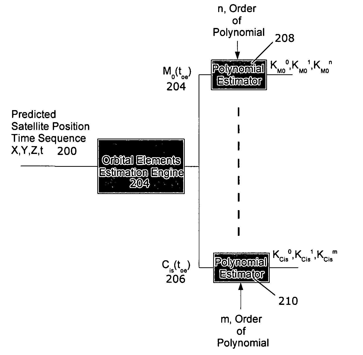
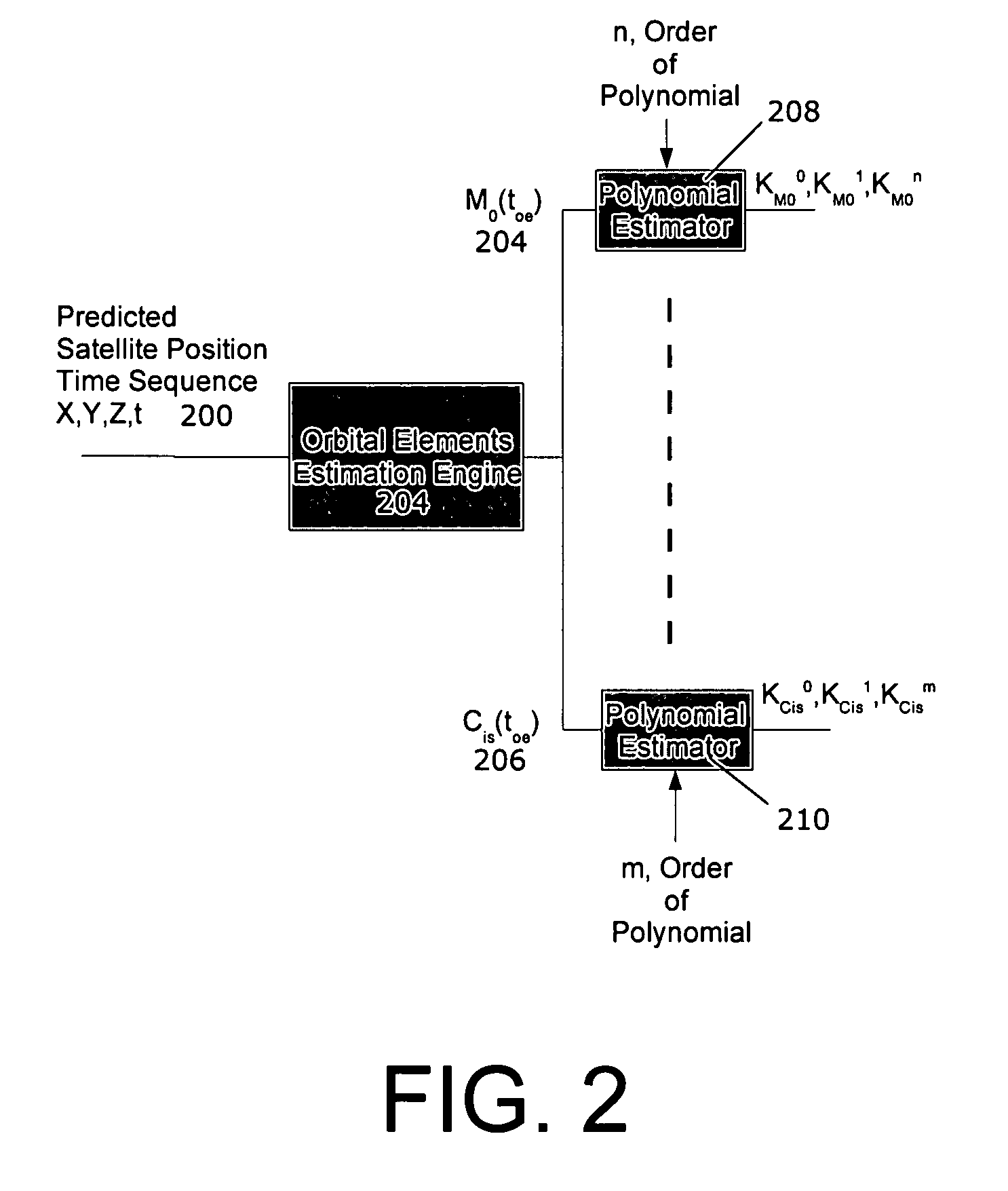
[0014]Embodiments of the present invention are explained hereinafter with particular reference to the figures. In one embodiment of the present invention, a method for expressing forward in time satellite position prediction information in a way as compact and simple as possible, such that transmission to the receiver via an assistance network is as fast and efficient as possible.

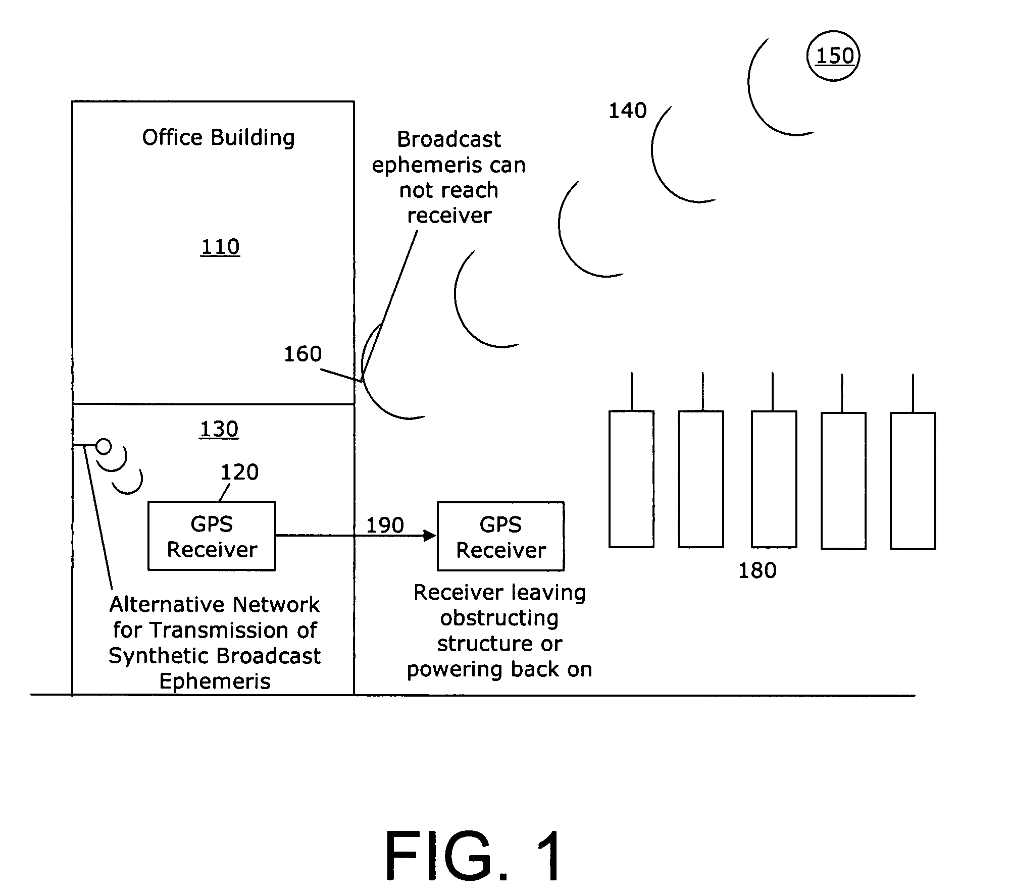
[0015]FIG. 1 illustrates an example function of Ephemeris Extension technology. In the figure there is an office building 110 under which a GPS receiver 120 is located in a parking garage 130. The Broadcast Ephemeris 140 of GPS satellites 150 cannot be received 160 by the GPS receiver 120 when it is located in the underground parking garage 130. The same reception prevention could occur if the GPS receiver 70 were powered down.

[0016]Ephemeris Extension technology is useful for when the GPS receiver is powered back on or is removed from the obstructing structure 190 and placed in an area where Broadcast Ephe...


PUM


Abstract

Methods and devices for calculating long-validity satellite prediction data, compacting such data and providing the data GNSS receivers are presented. The data are compacted using a multistage compaction approach which takes physical models into account and produces an extremely low-memory satellite prediction data file size for transmission to remote receivers.

Description

CROSS REFERENCE TO RELATED APPLICATIONS[0001]This application claims priority from U.S. provisional application 60 / 815,838, filed Jun. 23, 2006, the contents of which are incorporated by reference in their entirety including the specification, drawings and claims.FIELD OF THE INVENTION[0002]The present invention relates generally to Global Navigation Satellite System (GNSS) techniques for determining a receiver's position. More specifically, the present invention relates to technology that allows for prediction of a GNSS receiver's location much longer than that which would be possible using standard GNSS techniques.BACKGROUND OF THE INVENTION[0003]The Global Positioning System (GPS) is one type of Global Navigation Satellite System (GNSS). While other types of Global Navigation Satellite Systems exist, for example the Galileo system, the GPS can be taken as exemplary for purposes of the present description. Typically, a GPS receiver calculates its position through use of Broadcast ...

Claims


Application Information

Patent Timeline
IPC IPC(8): G01C21/00G01S19/25G01S5/14
CPCG01S19/05G01S19/27G01S19/258
Inventor GARIN, LIONELMOLE, STEVE
Owner QUALCOMM INC
Why Eureka
Try Eureka