

Method, system and computer program for detecting and monitoring human activity utilizing location data
a technology of location data and human activity, applied in the field of tracking human beings, can solve the problems of difficult recall for people, limited current lbs, and other tracking technologies that will never provide the ability to completely replicate a person's activity-travel pattern, and achieve the effect of low cos
- Summary
- Abstract
- Description
- Claims
- Application Information
AI Technical Summary
Benefits of technology
Problems solved by technology
Method used
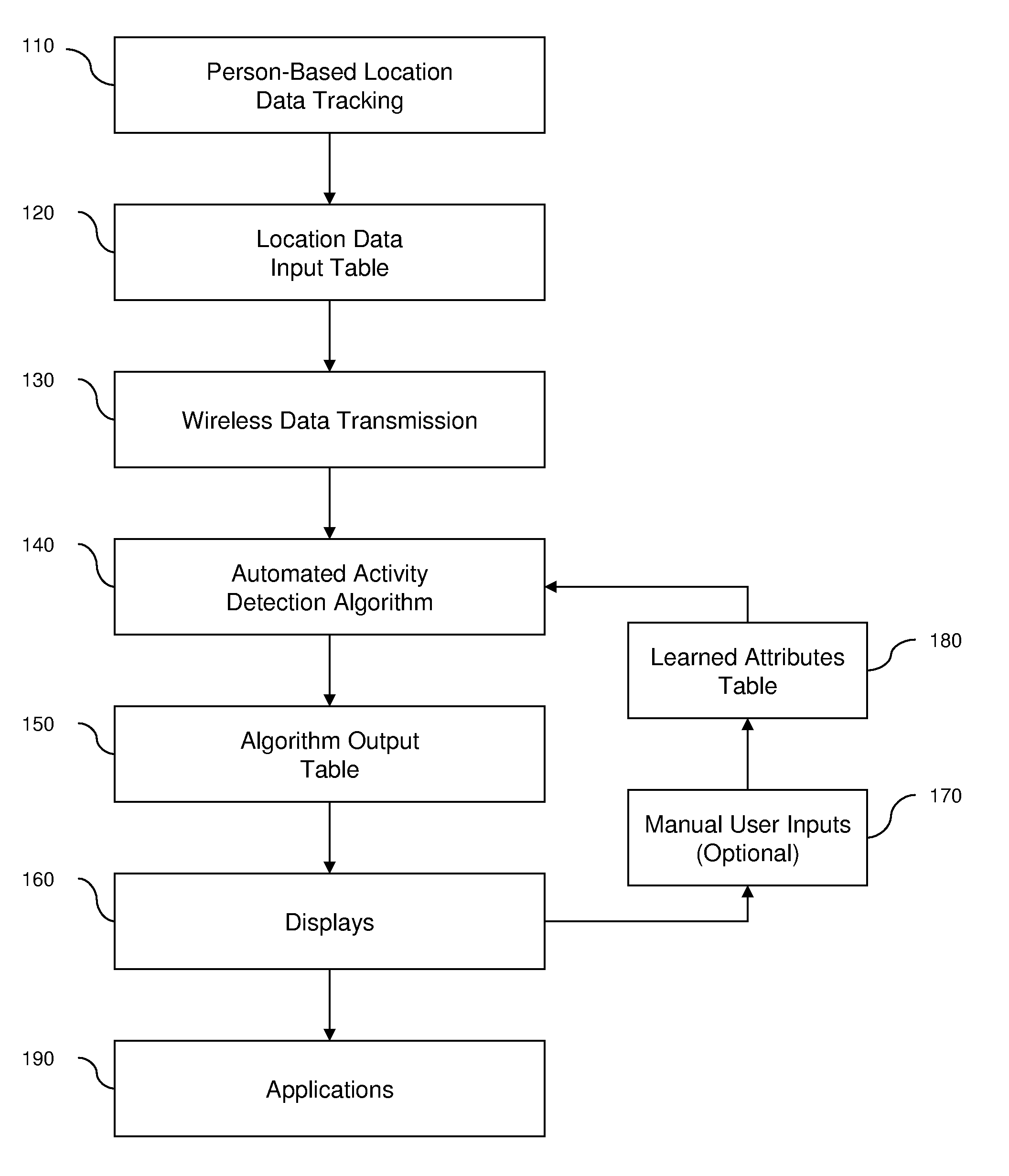
Image

Examples
case 1
[0085]Case 1: T→L→T Converted to {T→A→T} or {T}
[0086]This relates to short signal losses en-route result from tunnels (e.g., bridges, subways), urban canyons (tall buildings), canopies (e.g., trees), etc. These are converted as follows:[0087]a) Very short L's are simply converted to T's (Rule: L duration[0088]b) Longer L's that span a logical length and speed (i.e. lost signal, but picked it up again a reasonable distance away given time and speed) are also merged to a single T.[0089]c) Longer L's that could potentially have contained a stationary stop are converted to an A (recognizing that even though no A's were initially coded, the long loss likely resulted from stopping suddenly in a location before speeds dropped); however, if the distance between T's is large enough, the end time of the new A and start time of the second T is shifted back in time.[0090]d) Otherwise, L remains as unknown time period.
case 2
[0091]Case 2: A→L→A Converted to {A→T→A} or {A}
[0092]Similar to above, short and long periods of signal loss often occurs in buildings.[0093]a) When the A's are within close proximity of each other (Rule: A spatial means are within x meters of each other) the A's and L are merged into a single A. The y is quite large to allow long periods spent in certain activities (e.g., work, at-home).[0094]b) If the two A's are greater than x meters apart and the L spans a logical length and speed of movement, it is fully converted to a T.[0095]c) If the two A's are greater than x meters apart and the L spans does not span a logical length and speed of movement then the second A start and new T end time are shifted back in time.[0096]d) Otherwise, L remains as unknown time period.
case 3
[0097]Case 3: T→A→L→A Converted to T→A
[0098]Signal losses will occur occasional between Trips and Activities, such as on entry to a parking garage. Logic similar to the above is used to split the L into T and A portions.
PUM
 Abstract
Description
Claims
Application Information