Satellite differential positioning receiver using multiple base-rover antennas

a satellite differential positioning and receiver technology, applied in the field of satellite differential positioning system data processing, can solve problems such as multipath error, distortion of raw measurements, and type of errors, and achieve the effect of reducing the expected accuracy

Active Publication Date: 2009-07-30
JAVAD GNSS
View PDF3 Cites 72 Cited by
  • Summary
  • Abstract
  • Description
  • Claims
  • Application Information

AI Technical Summary

Benefits of technology

[0022]In either case, the base transceiver may transmit to the rover either raw measurements (e.g., pseudorange and carrier phase) or corrections (e.g., pseudorange and carrier phase corrections) with respect to each navigational satellite (of at least four satellites). Because the base employs multiple antennas, base processing logic may average the corrections to enable the base transceiver to transmit to the rover receiver an average correction. In this manner, the multiple base antennas appear to the rover to act as one effective base antenna, resulting in one effective baseline between the base and each rover antenna. The rover processing logic measures its own position (e.g., pseudorange and carrier phase) with respect to the GNSS satellites, and uses the raw measurements or corrections from the base to correct its determination of rover position.
[0023]In addition to determining the position of the rover master antenna using the techniques above (for the spatially symmetric arrangement), the rover processing logic may also determine the master antenna position by simply averaging the positions of the rover auxiliary antennas determined using the above techniques. By comparing the averaged master antenna position to the estimated position determined by the above techniques, the rover processing logic provides a cheek on the accuracy of the master antenna position determined by embodiments of the invention herein. If the difference between the averaged position and the estimated positions exceed a predetermined threshold, then the rover processing logic may indicate to a user a decrease in expected accuracy, or reset its algorithm to start computing rover position from scratch (because the current algorithm may have accumulated anomalous errors).

Problems solved by technology

The practical implementation of this scheme runs into the problem of ambiguities in the phase measurements.
Well-known sources of such errors are ionospheric delays and ephemeris errors.
Well known sources of this type of error are noise-like errors and multipath errors.
Multipath errors are caused by reflection of the radio signal from surfaces located near the antenna.
The combination of two (or more) signals at the antenna leads to the distortion of raw measurements.
Shading of signals coming from one or several satellites and tracked by the receiver may cause measurements to become unavailable.
As a consequence, in conventional systems the receiver, working in either standalone or differential modes, can lose the ability to determine position.

Method used


Image

  • Satellite differential positioning receiver using multiple base-rover antennas
  • Satellite differential positioning receiver using multiple base-rover antennas
  • Satellite differential positioning receiver using multiple base-rover antennas

Examples


Embodiment Construction

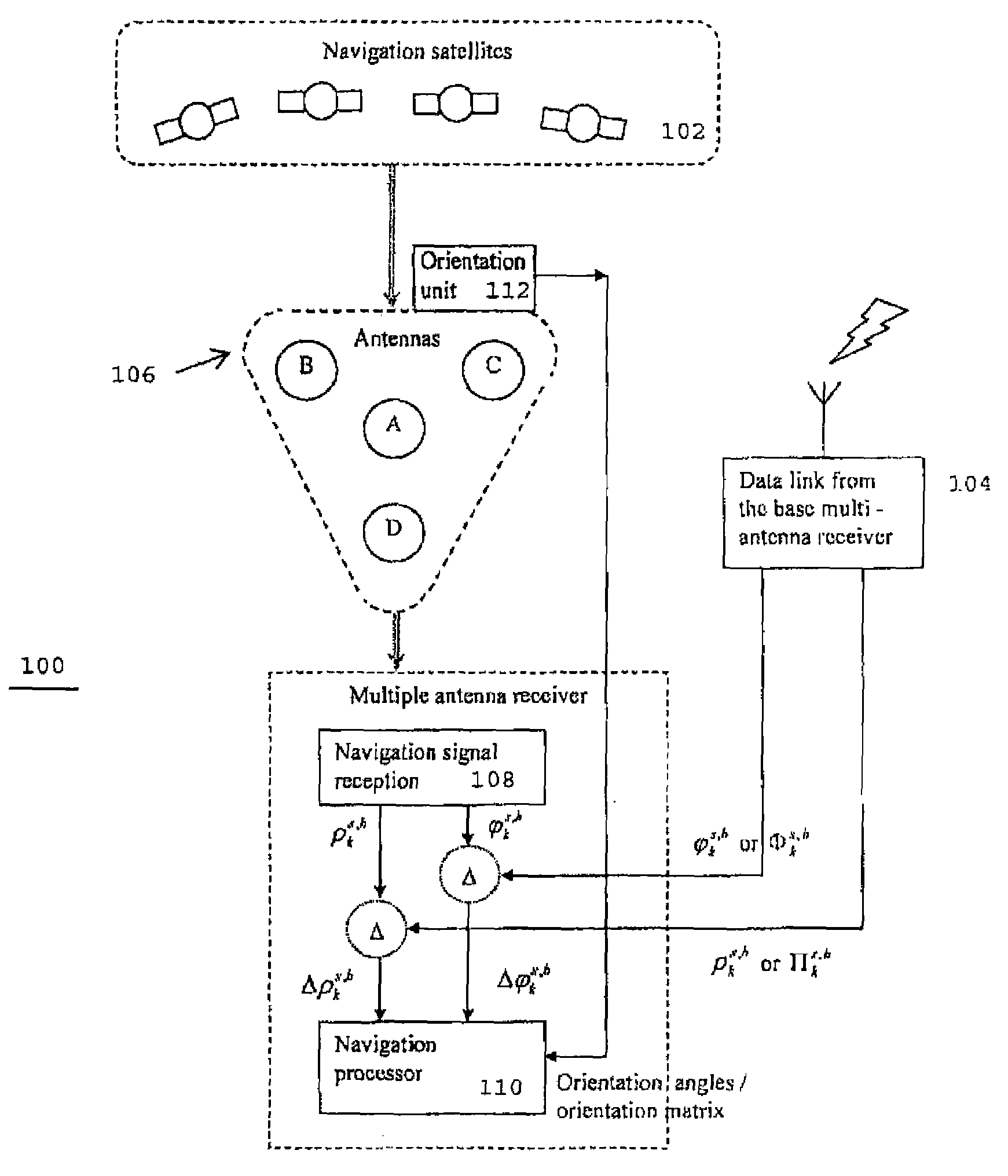
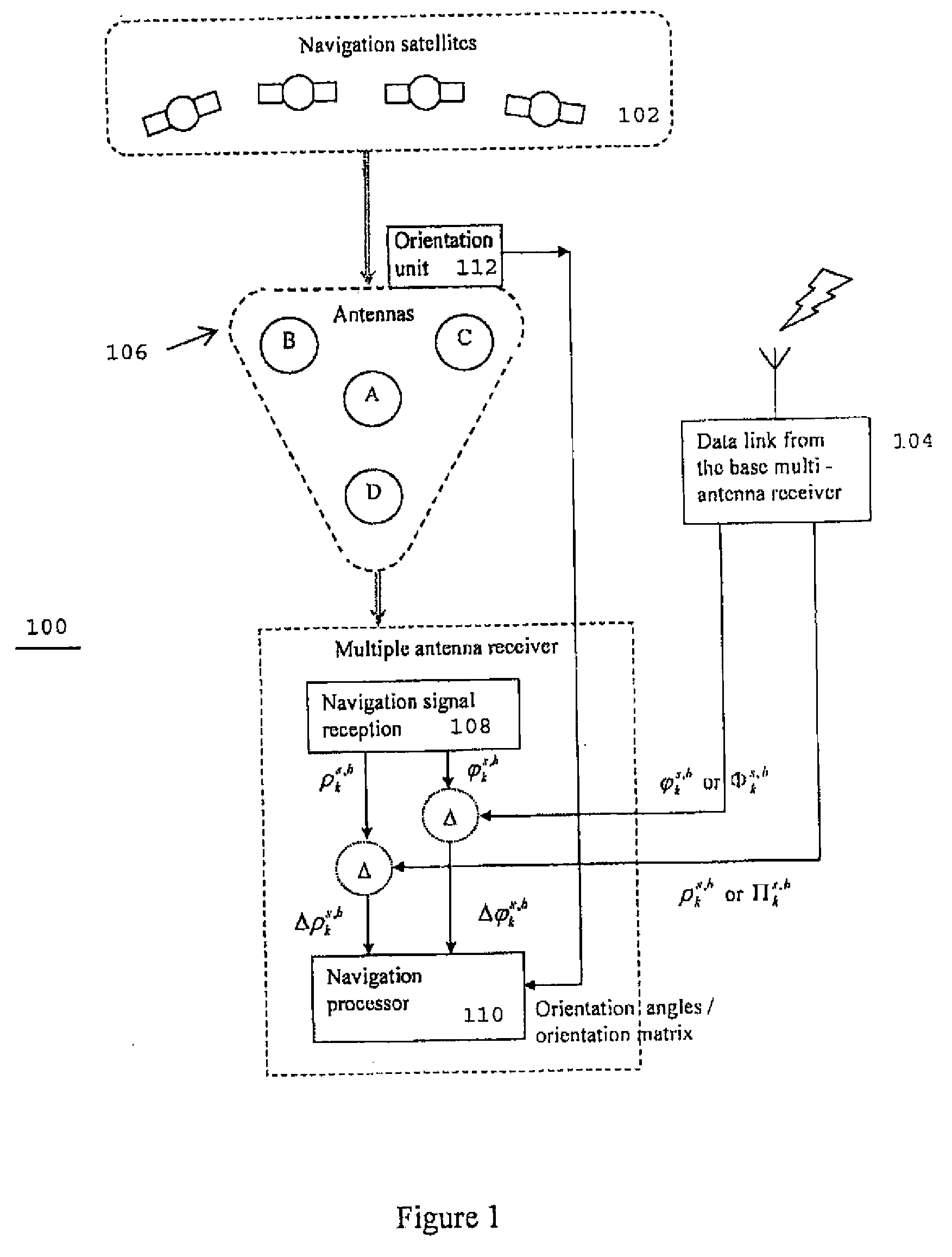
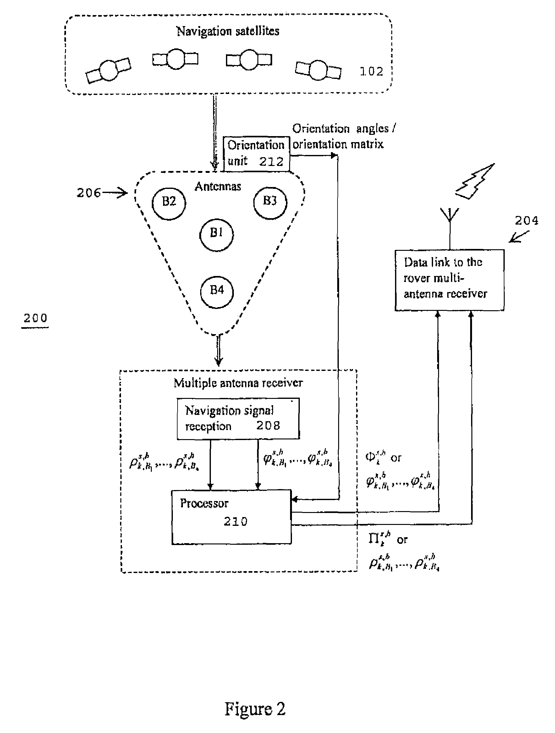
[0030]In one embodiment, the present invention employs two multiple-antenna systems, one as base and the other as rover. Without loss of generality, this specification will primarily describe a base and a rover that each employ four-antenna assemblies.

[0031]FIG. 1 illustrates a rover receiver 100 according to embodiments of the invention in communication with navigation satellites 102 and a base transceiver (through a data link). As shown, the rover receiver 100 includes an antenna assembly 106 of four spatially symmetric antennas—master antenna A and auxiliary antennas B, C and D. A navigation signal receiver 108 receives satellite navigation signals through the antenna assembly to produce pseudorange and carrier phase measurements, which are provided to a navigation processor 110,

[0032]A rover-side data link 104 receives either raw pseudorange and carrier phase measurements or positional corrections from the base. The navigation processor 110 (i.e., rover processing logic) determi...


PUM


Abstract

A rover processor determines position of a rover based upon the interaction between multiple antennas located at the rover and multiple antennas located at a base. The rover antennas may include a rover master antenna having a phase center located at the centroid of the antennas patterns of at least two auxiliary rover antennas. The rover processor may determine the position of the rover master antenna based upon the relative positions of at least two rover antennas (e.g., the rover master antenna and at least one rover auxiliary antenna, or at least two rover auxiliary antennas) with respect to at least two antennas of a base transceiver.

Description

CROSS REFERENCE TO RELATED APPLICATIONS[0001]This application claims the benefit under 35 USC 119(e) of prior copending U.S. Provisional Patent Application No. 61 / 063,155, filed Jan. 30, 2008, the disclosure of which is hereby incorporated by reference in its entirety.FIELD OF THE INVENTION[0002]The present invention relates to data processing in satellite differential positioning systems employing multiple base and rover antennas.BACKGROUND OF THE INVENTION[0003]Navigation receivers that use global navigation satellite systems, such as GPS or GLONASS (hereinafter collectively referred to as “GNSS”), enable the highly accurate determination of the position of the receiver. The satellite signals comprise earner harmonic signals that are modulated by pseudo-random binary codes and which, on the receive side, are used to measure the delay relative to a local reference clock. These delay measurements are used to determine the so-called pseudo-ranges between the receiver and the satellit...

Claims


Application Information

Patent Timeline
Patent Type & Authority Applications(United States)
IPC IPC(8): G01S1/00G01S19/44
CPCG01S19/14G01S19/54G01S19/44
Inventor ASHJAEE, JAVADRAPOPORT, LEV B.KINKULKIN, DMITRYYEFRIEMOV, VLADIMIR
Owner JAVAD GNSS
Why Eureka
Try Eureka