Method and System to Calculate Historical Traffic Data

a traffic data and historical technology, applied in the field of providing driving directions from a vehicle navigation system, to achieve the effect of accurate calculation of travel times

Inactive Publication Date: 2009-12-31
GENERA MOTORS LLC
View PDF3 Cites 28 Cited by
  • Summary
  • Abstract
  • Description
  • Claims
  • Application Information

AI Technical Summary

Benefits of technology

[0003]Aspects of the invention provide for a system and method for a vehicle navigation system to accurately calculate travel times between locations and then provide for a vehicle driver requesting directions for the shortest time route instead of the shortest distance route based on the time-of-day. Each route request is entered into a navigation server that is part of the vehicle navigation system and contains the destination, the vehicle's current location, and time-of-day information. The navigation server compiles data of common road segments between two locations that are contained in the route requests. The navigation server subsequently analyzes the data to calculate the travel time between the two locations. When subsequent route requests contain further information pertaining to the same two locations, the navigation server updates the travel time between the two locations.

Problems solved by technology

For example, the shortest distance route may have high traffic congestion during rush hour and thus may not be the shortest time route at that time.

Method used


Image

  • Method and System to Calculate Historical Traffic Data
  • Method and System to Calculate Historical Traffic Data
  • Method and System to Calculate Historical Traffic Data

Examples


Embodiment Construction

[0010]Before describing the invention in detail, an exemplary environment in which the invention may operate will be described. It will be appreciated that the described environment is for purposes of illustration only, and does not imply any limitation regarding the use of other environments to practice the invention.

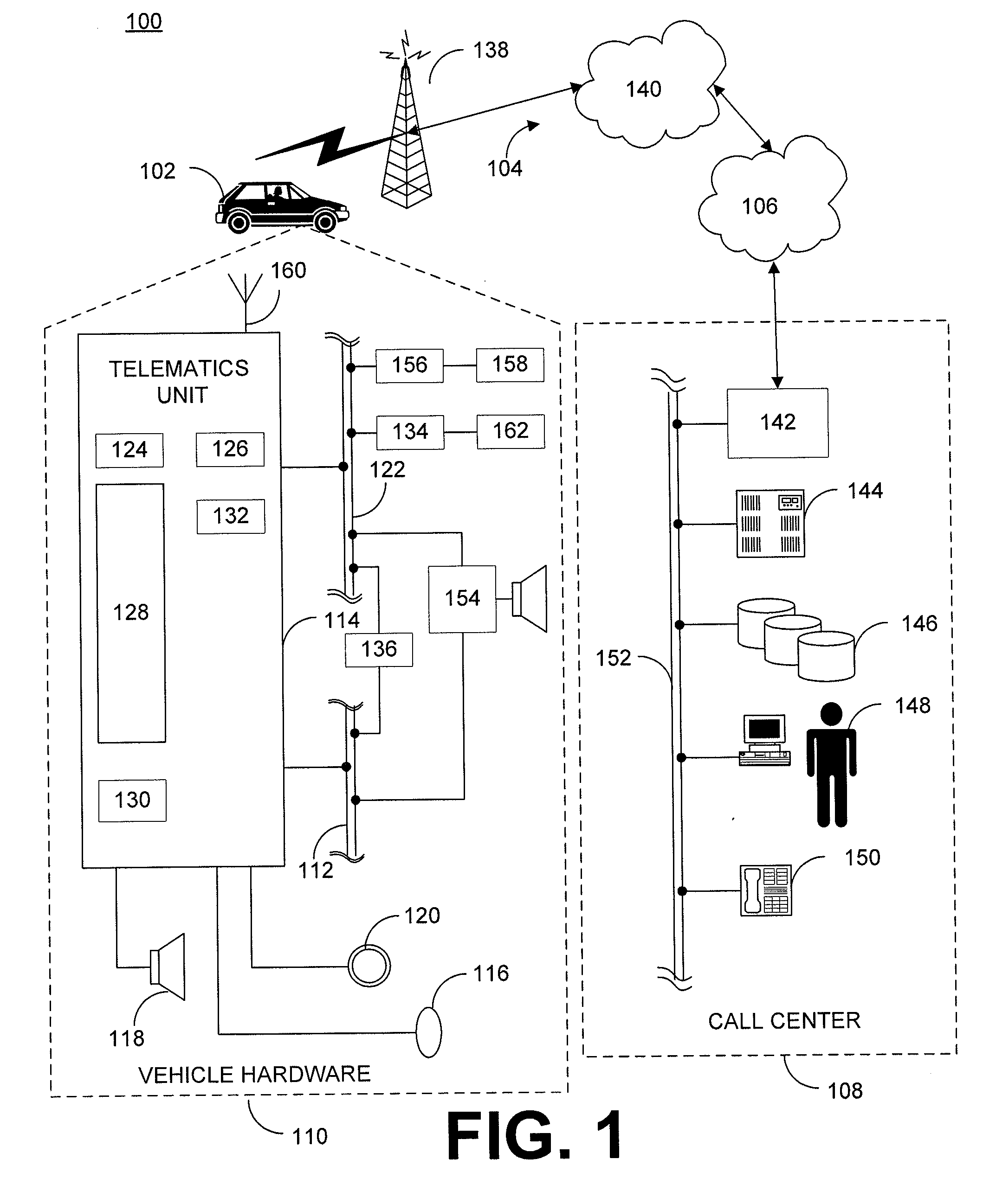
[0011]With reference to FIG. 1 there is shown an example of a communication system 100 that may be used with the present method and generally includes a vehicle 102, a wireless carrier system 104, a land network 106 and a call center 108. It should be appreciated that the overall architecture, setup and operation, as well as the individual components of a system such as that shown here are generally known in the art. Thus, the following paragraphs simply provide a brief overview of one such exemplary information system 100; however, other systems not shown here could employ the present method as well.

[0012]Vehicle 102 is preferably a mobile vehicle such as a motorcycle...


PUM


Abstract

A system for a vehicle navigation accurately calculates travel times between locations and serves a vehicle driver request for the shortest time route. A navigation server compiles data of common road segments between two locations that are contained in route requests and subsequently calculates travel time between the two locations. When subsequent route requests contain further information pertaining to the same locations, the navigation server updates the travel time. Consequently, the navigation server can calculate the travel times of different routes from the same source vehicle location and destination location. When a vehicle driver requests directions from the vehicle's current location to a destination, the navigation server then provides directions for the shortest time route to the vehicle driver.

Description

FIELD OF THE INVENTION[0001]The present invention relates generally to providing driving directions from a vehicle navigation system, and in particular to a method and system of using historical traffic data to calculate accurate travel times when providing driving directions for a shortest route with respect to time from a vehicle navigation system.BACKGROUND OF THE INVENTION[0002]A vehicle driver may use a telematics unit as part of a vehicle navigation system to provide him or her with turn-by-turn directions. When the vehicle driver requests directions, the telematics unit sends a route request to a navigation server that is also part of the vehicle navigation system that contains the vehicle's current location, time-of-day, and destination. Thereafter, the vehicle navigation system provides turn-by-turn directions of the shortest route with respect to distance from the vehicle's current location to the destination. However, the shortest route with respect to distance (shortest ...

Claims


Application Information

Patent Timeline
Patent Type & Authority Applications(United States)
IPC IPC(8): G01C21/36G06F17/30
CPCG08G1/096811G01C21/3492
Inventor JOHNSON, RICHARD A.
Owner GENERA MOTORS LLC
Why Eureka
Try Eureka