Method for compressing elevation maps

a technology of elevation maps and compression methods, applied in the field of terrain simplification methods, can solve the problems of inability to compress multimedia data, inability to meet the requirements of data storage capacity and transmission bandwidth, and the demand for data storage capacity and data-transmission bandwidth continues to out-perform the capabilities of available technologies, so as to achieve high geometric quality, reduce the effect of labor intensity

Inactive Publication Date: 2010-03-11
ARIEL UNIV RES & DEV
View PDF5 Cites 16 Cited by
  • Summary
  • Abstract
  • Description
  • Claims
  • Application Information

AI Technical Summary

Benefits of technology

[0025]The present invention relates to a method for the terrain simplification and for compressing elevation maps in an efficient and relatively fast way, providing the compressed elevation maps in relatively high geometric quality.

Problems solved by technology

Uncompressed multimedia data requires considerable storage capacity and transmission bandwidth.
In spite of the rapid progress in mass-storage density, processing speeds, and digital communication system performance, the demand for the data storage capacity and data-transmission bandwidth continues to outstrip the capabilities of available technologies.
The prior art data compression methods / standards are either lossy or lossless.
The compression ratio of conventional lossless methods (such as Huffman encoding, Arithmetic encoding, LZW (Lempel-Ziv-Welch) encoding) is relatively low and not high enough for providing efficient image and / or video compression, especially when the distribution of pixel values within the image is relatively flat.
Thus, the images compressed by such methods usually cannot be displayed on mobile devices (such as cellular phones, PDAs (Personal Digital Assistants), etc.) due to the limited computation power and limited memory resources.
However, these methods are slow by nature due to the TIN terrain representation that require large computational resources, leading to the large error rate and to the low compression rate, and as a result, to a large file size and inefficient runtime.
However, all these terrain simplification methods do not provide sufficient results and the compressed image has low geometric quality and large file size.
In addition, MSE error (Mean Squared Error), MAE error (Mean Absolute Error) and RMS error (Root Mean Squared Error) of the compressed image are high, and the PSNR (Peak Signal-to-Noise Ratio) of said compressed image is relatively low, corresponding to high error rates.
As a result, images compressed by means of the conventional lossless compression methods are large in size.
However, WO 2006 / 057477 does not teach performing preprocessing of an elevation map to be compressed, and does not teach implementing digital image processing methods for performing terrain simplification.

Method used


Image

  • Method for compressing elevation maps
  • Method for compressing elevation maps
  • Method for compressing elevation maps

Examples


Embodiment Construction

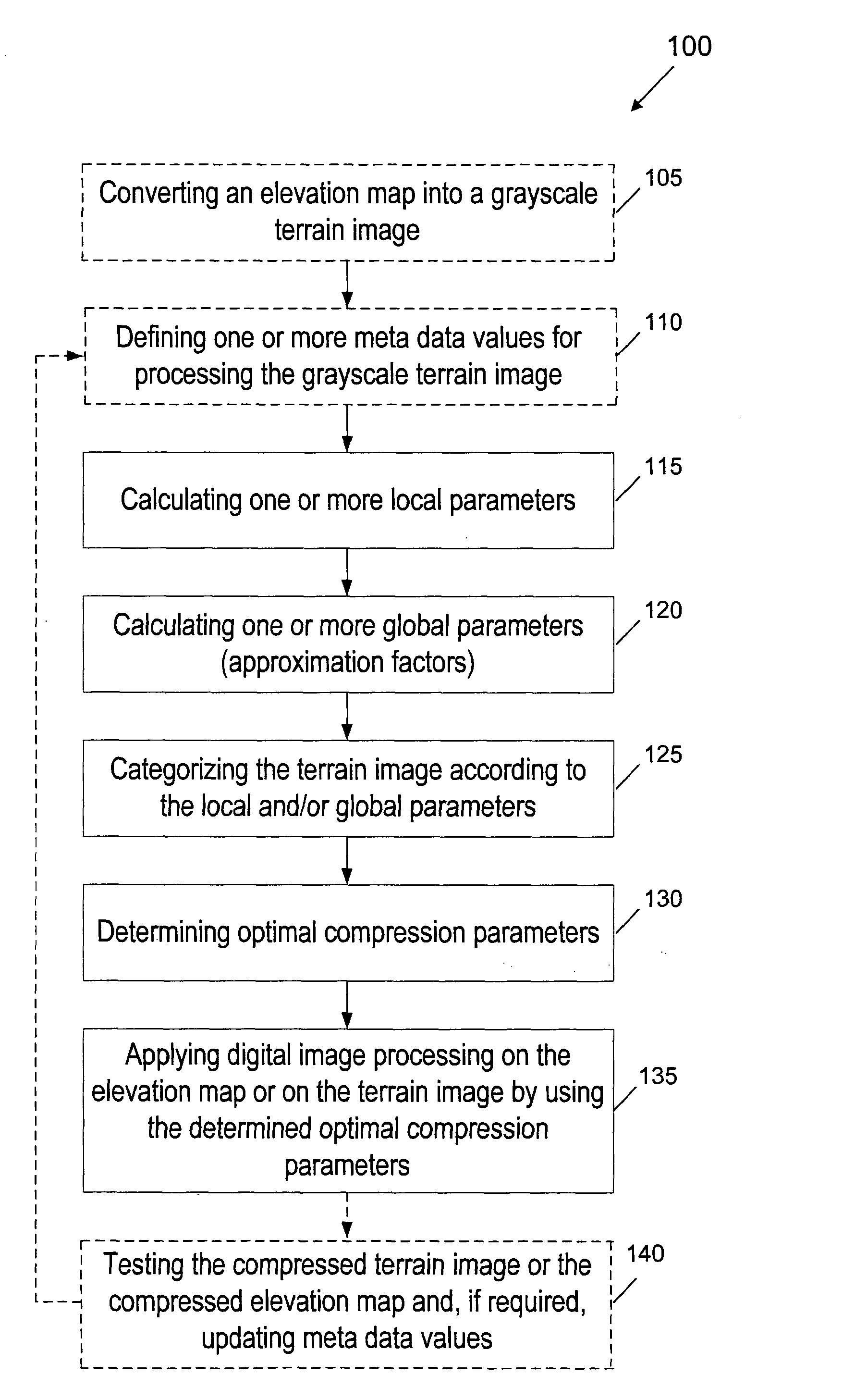
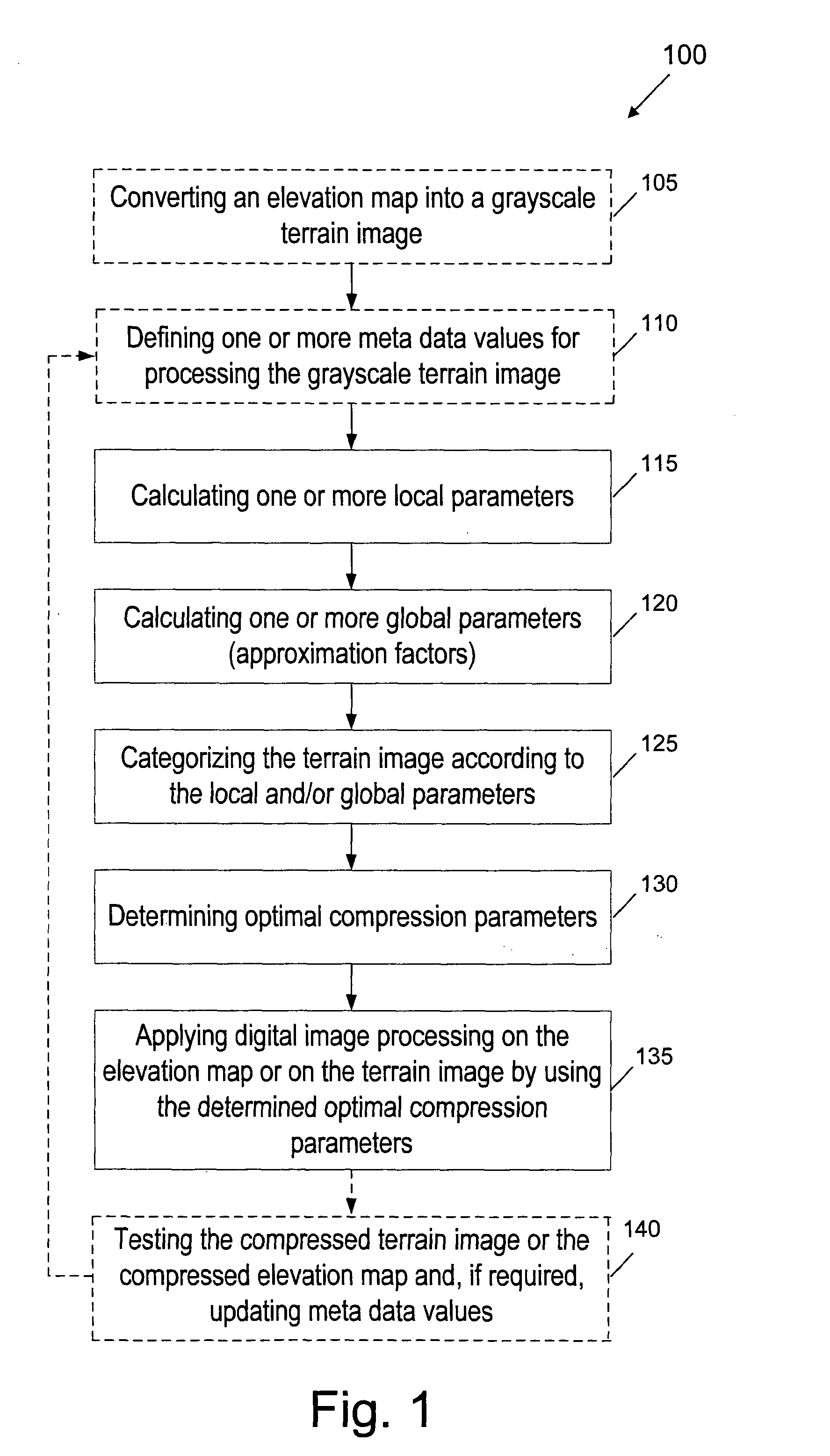
[0038]FIG. 1 is a flow chart 100 of an image compression terrain simplification (ICTS) method for compressing elevation maps, according to a preferred embodiment of the present invention. The ICTS method comprises: (a) a preprocessing stage (steps 105 to 130) for converting an elevation map into a corresponding grayscale terrain image, and calculating local and global parameters of each terrain image, classifying (categorizing) each terrain image and, as a result, determining optimal compression parameters (such as quantization parameters) for compressing said image; and (b) a conventional digital image processing stage (step 135) for performing optimal compression of the terrain image, according to the determined optimal compression parameters. In addition, the compressed terrain image can be further tested (step 140) by a user, and if required, the compression parameters can be further updated.

[0039]It is supposed, for example, that an input for the ICTS method is a grid-based ele...


PUM


Abstract

A method for compressing an elevation map by means of digital image processing, according to which local and global parameters of an elevation map are calculated for sorting the elevation map into a corresponding category and the elevation map is categorized according to the calculated local and global parameters. Optimal parameters for compressing the elevation map are determined according to the calculated local and global parameters and according to the corresponding category and then the elevation map is compressed by applying on it digital image processing by using the determined optimal compression parameters.

Description

FIELD OF THE INVENTION[0001]The present invention relates to terrain simplification methods. More particularly, the invention relates to an Image Compression Terrain Simplification (ICTS) method for the terrain simplification and for compressing elevation maps in an efficient and relatively fast way, providing the compressed elevation maps in relatively high geometric quality.DEFINITIONS, ACRONYMS AND ABBREVIATIONS[0002]Throughout this specification, the following definitions are employed:[0003]DEM: is a short for the Digital Elevation Model that is a type of a digital terrain model, recording a topographical representation of the terrain of the Earth or another surface in the digital format, and making it possible to digitally produce elevation maps.[0004]DTED: is a short for Digital Terrain Elevation Data that is a standard digital dataset, which is a uniform matrix of terrain elevation values providing basic quantitative data for systems and applications that require terrain elev...

Claims


Application Information

Patent Timeline
Patent Type & Authority Applications(United States)
IPC IPC(8): G06K9/36G06T17/05
CPCG06T17/05H04N19/172H04N19/192H04N19/14H04N19/17H04N19/103
Inventor BEN-MOSHE, BOAZSERRUYA, LIADSHAMIR, ARIK
Owner ARIEL UNIV RES & DEV
Why Eureka
Try Eureka