Path calculation method based on location information

a calculation method and location information technology, applied in navigation instruments, navigation services, instruments, etc., can solve the problems of complicated navigation operation for users, user input operation is still complicated and difficult, and navigation operation for users becomes complicated and difficult, so as to simplify navigation

Inactive Publication Date: 2010-06-10
INVENTEC APPLIANCES CORP
View PDF6 Cites 12 Cited by
  • Summary
  • Abstract
  • Description
  • Claims
  • Application Information

AI Technical Summary

Benefits of technology

[0010]In view of this, the present invention is directed to a path calculation method based on coordinate information recorded within the location information, no matter where the location information is obtained, so as to decrease inconveniences of text input by a user, and shorten an input time.
[0013]First, with this method, the navigation device may perform calculation of a navigation path no matter where the location information is obtained, without manually inputting related coordinates or addresses, thereby effectively reducing the difficulties and complexities of the path navigation and shortening the input time.
[0015]Third, when the user of the electronic device and the user of the navigation device are the same person, the user may transmit the location information of a destination with the electronic device to the navigation device, so as to simplify the navigation. If the user of the electronic device and the user of the navigation device are different persons, the navigation device may plan or calculate a navigation path between the navigation device and the electronic device according to the location information provided by the electronic device, so as to guide the user of the navigation device to head for the location of the user of the electronic device.

Problems solved by technology

Input operation for a user is still complicated and difficult.
Navigation operation for a user becomes more complicated and difficult.

Method used


Image

  • Path calculation method based on location information
  • Path calculation method based on location information
  • Path calculation method based on location information

Examples


Embodiment Construction

[0022]To provide a better understanding of the objectives, structure features, and functions of the present invention, the present invention is illustrated in detail in conjunction with related embodiments and drawings.

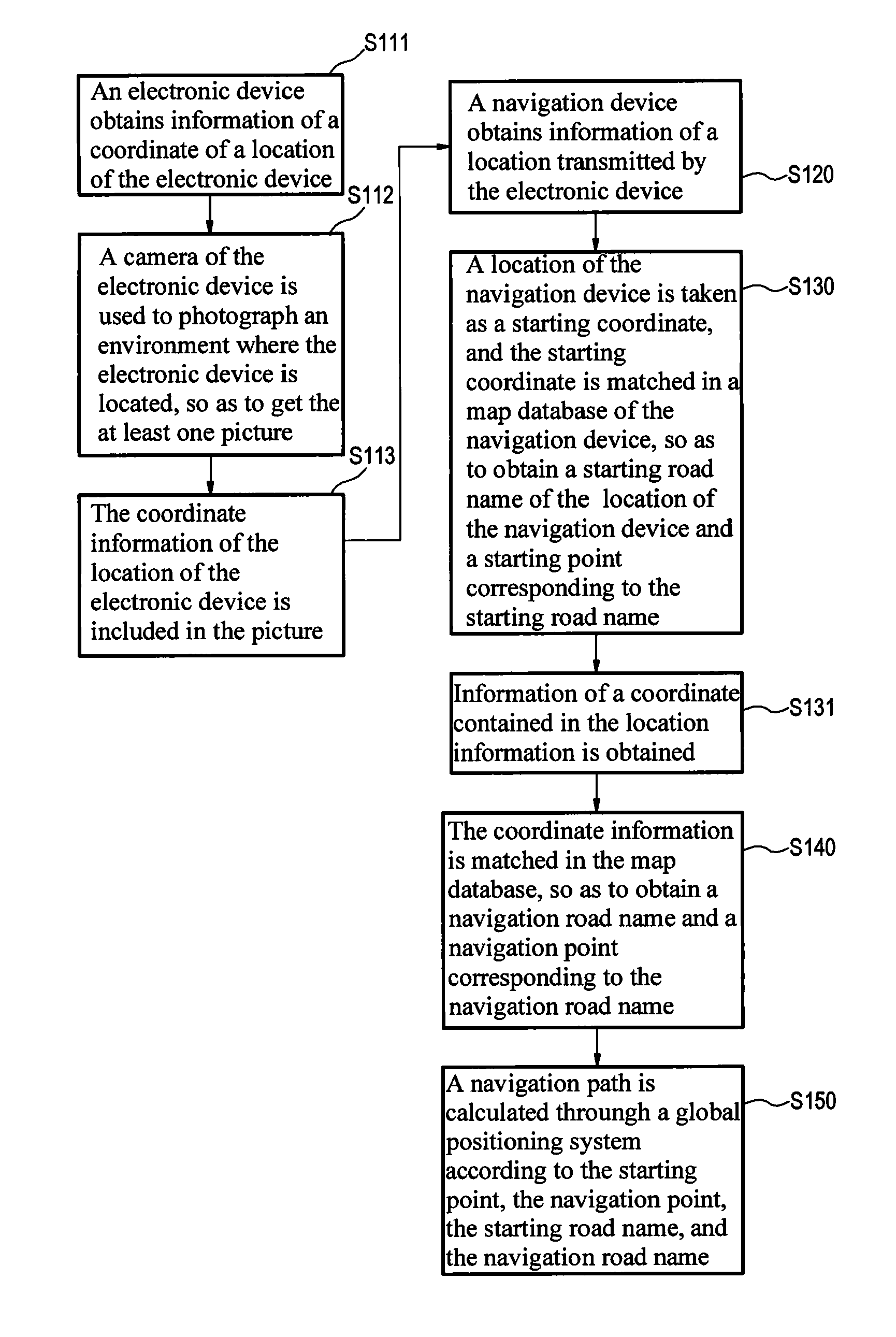
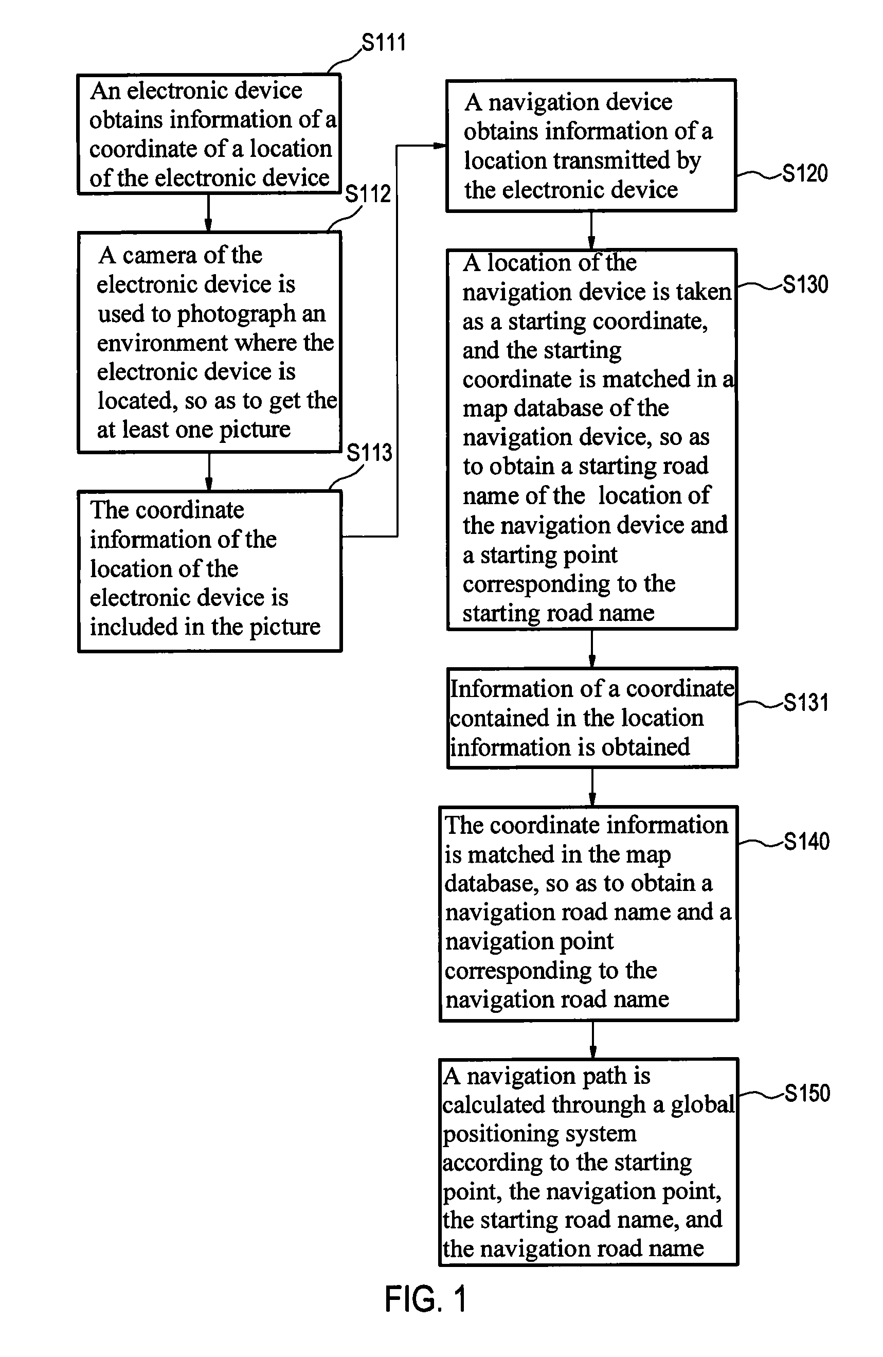
[0023]FIG. 1 is a flow chart of a method according to an embodiment of the present invention.

[0024]The method is applied to a navigation device 100. Referring to FIG. 3 at the same time, in this embodiment, the navigation device 100 is equipped with a global positioning system (GPS) 110. The method includes the following steps.

[0025]At least one location information 121 is stored in an electronic device 300. This step mainly illustrates that before navigation path calculation, one or more location information 121 needs to be prepared. This type of location information 121 is a picture 321 or a text information 323. If the location information 121 is the picture 321, the picture 321 is a photo of a scene at a certain spot.

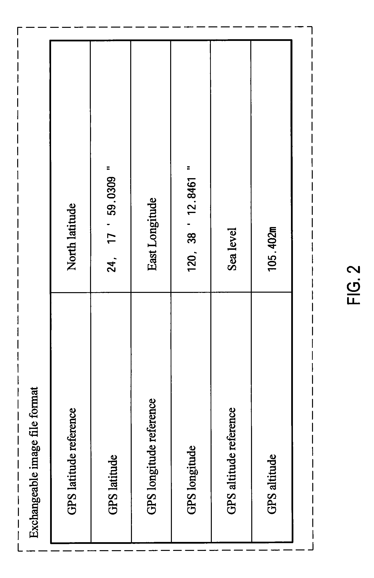
[0026]The picture 321 includes the coordinate i...


PUM


Abstract

A path calculation method based on location information is provided. The method is applied to a navigation device. In this method, the navigation device obtains information of a location transmitted by an electronic device. The location information is a text information or a picture. The navigation device obtains information of a coordinate contained in the location information, a starting road name to which its own location belongs and a corresponding starting point, as well as a navigation road name to which the coordinate information belongs and a corresponding navigation point. The navigation device then calculates a best navigation path according to the above information through a global positioning system (GPS). By this method, the navigation device may perform navigation path planning or calculation upon reading the location information, so as to shorten time for a user to input text and coordinates.

Description

CROSS-REFERENCE TO RELATED APPLICATION[0001]This application claims the benefit of Taiwan Patent Application No. 097147642, filed on Dec. 8, 2008, which is hereby incorporated by reference for all purposes as if fully set forth herein.BACKGROUND OF THE INVENTION[0002]1. Field of Invention[0003]The present invention relates to a navigation method, and more particularly to a path calculation method based on location information.[0004]2. Related Art[0005]In all global positioning systems (GPSs) of existing navigation machines in the prior art, no matter the GPS is used in car navigation, or in pedestrian navigation, it is designed that a user first sets a starting point, an ending point, navigation preferences (such as a shortest path, a lightest road traffic, and entering / not entering special roads), and then the navigation machine utilizes the GPS to perform navigation according to the previous settings.[0006]For convenience of a user, a map database is improved by providing drawings...

Claims


Application Information

Patent Timeline
Patent Type & Authority Applications(United States)
IPC IPC(8): G01C21/36H04W64/00H04W4/12
CPCG01C21/36
Inventor CHEN, XUDONGTSAI, TONY
Owner INVENTEC APPLIANCES CORP
Why Eureka
Try Eureka