Advanced geographic information system (GIS) providing modeling, decision support, visualization, sonification, web interface, risk management, sensitivity analysis, sensor telemetry, field video, and field audio

a geographic information system and advanced technology, applied in the field of spatial information system, can solve the problems of insufficient capabilities and telemetry costs of gis applications, at best extremely limited gis systems, and achieve the effects of extending the potential customer base, extending the scope of environmental management, and widened and wiser environmental managemen

Inactive Publication Date: 2010-12-16
NRI R&D PATENT LICENSING LLC
View PDF3 Cites 52 Cited by
  • Summary
  • Abstract
  • Description
  • Claims
  • Application Information

AI Technical Summary

Benefits of technology

[0029]In particular, inclusion of one or more of above listed features 5-13 will considerably expand the capabilities, attractiveness, and market interest for the resultant technology, and as a result will greatly expand the potential customer base. Additionally, this overarching approach and architectures comprised by the invention can be used to create standards and interfaces. These in turn can be used to grow the industry as new sensors, analysis software, and science emerge.
[0030]The invention seeks to serve as an enabling technology for widened and wiser environmental management of contaminated industrial and military sites and to provide widespread economic benefits to public and private industry. The invention provides a wide-range of integrated enabling evolvable features detected towards, among other goals, effective, efficient and successful environmental management of land use, water use, the cleanup of contaminated sites, etc.

Problems solved by technology

GIS systems to date have had at best extremely limited, if any, incorporation of the following technologies that would add considerable new values, markets, and opportunities for good:Analytical Models: Many developing, evolving, and emerging environmental contamination situations are not well-defined contaminated sites, in particular at the urban and industry interfaces with waterways.
In highly cluttered visual displays, advanced data sonification can be used to convey yet additional data without further encumbering the visual field; however most sonification work is far too primitive or inappropriate for GIS applications.Data Sonification: Sonification is the use of non-speech audio to convey information or perceptualize data.
However, sonfication can be an extremely powerful tool is if data is expressed in terms of parameterized timbre variations.Field-located Sensors: Powerful new sensor capabilities and telemetry costs are radically evolving and improving yet are not integrated into contamination data systems or GIS utilities.
Narrow-scope tools limit the potential customer-base for these technologies which in turn limits the availability of the tools, competitive innovation, and constituent awareness.
Video and audio field sensors can provide very useful environmental information but are usually not considered as a useful field technology.
Despite the success of the web and public outreach of applications such as Google Maps / Terrain / Satellite, no effort has been made to provide a browser-based functionality for GIS-driven environmental analysis systems.Multidimensional User Input Devices: GIS and data navigation tools in GIS systems traditionally are limited to the 2D mouse or trackball.

Method used


Image

  • Advanced geographic information system (GIS) providing modeling, decision support, visualization, sonification, web interface, risk management, sensitivity analysis, sensor telemetry, field video, and field audio
  • Advanced geographic information system (GIS) providing modeling, decision support, visualization, sonification, web interface, risk management, sensitivity analysis, sensor telemetry, field video, and field audio
  • Advanced geographic information system (GIS) providing modeling, decision support, visualization, sonification, web interface, risk management, sensitivity analysis, sensor telemetry, field video, and field audio

Examples


Embodiment Construction

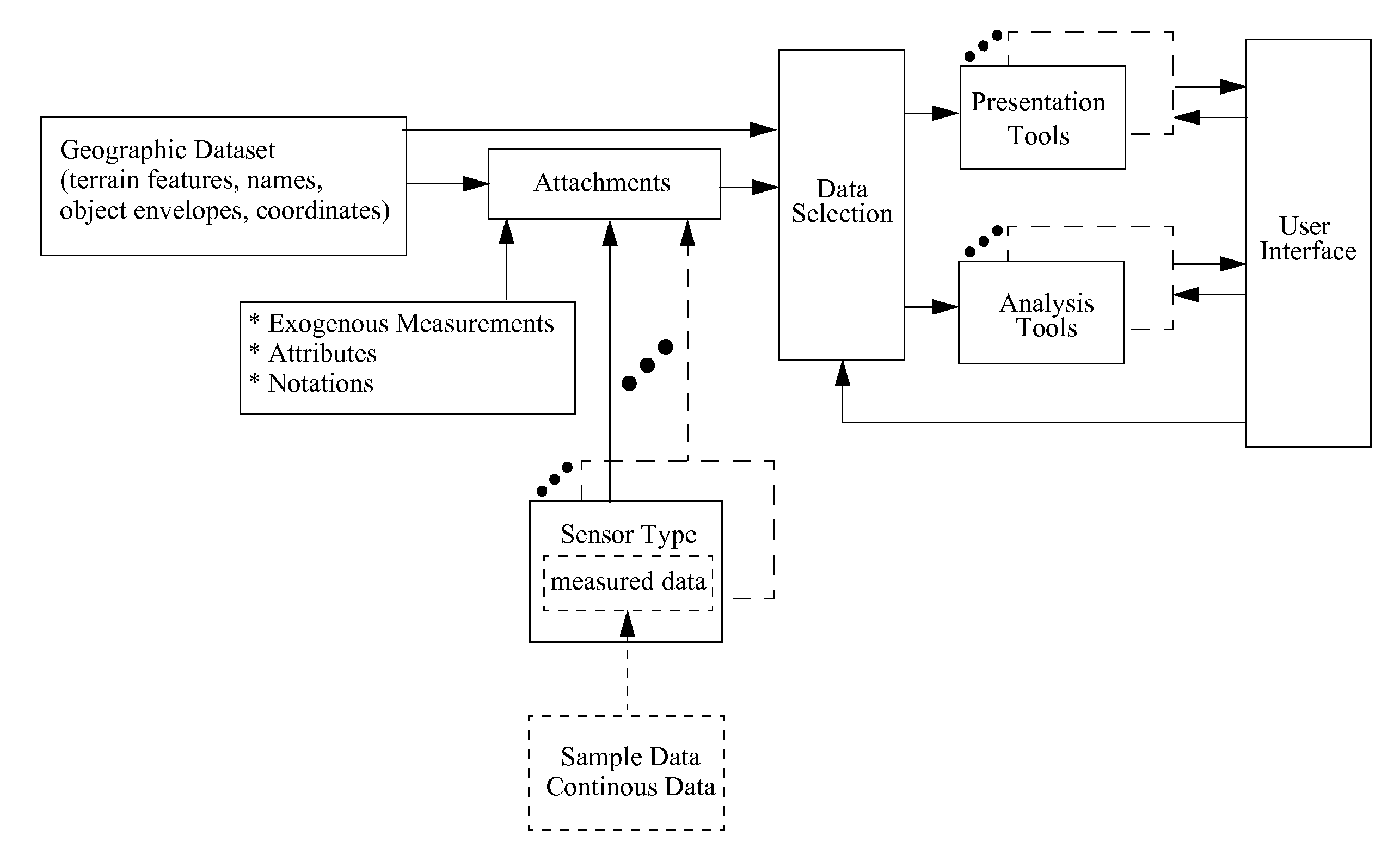
[0098]In the following detailed description, reference is made to the accompanying drawing figures which form a part hereof, and which show by way of illustration specific embodiments of the invention. It is to be understood by those of ordinary skill in this technological field that other embodiments can be utilized, and structural, electrical, as well as procedural changes can be made without departing from the scope of the present invention. Wherever possible, the same element reference numbers will be used throughout the drawings to refer to the same or similar parts.

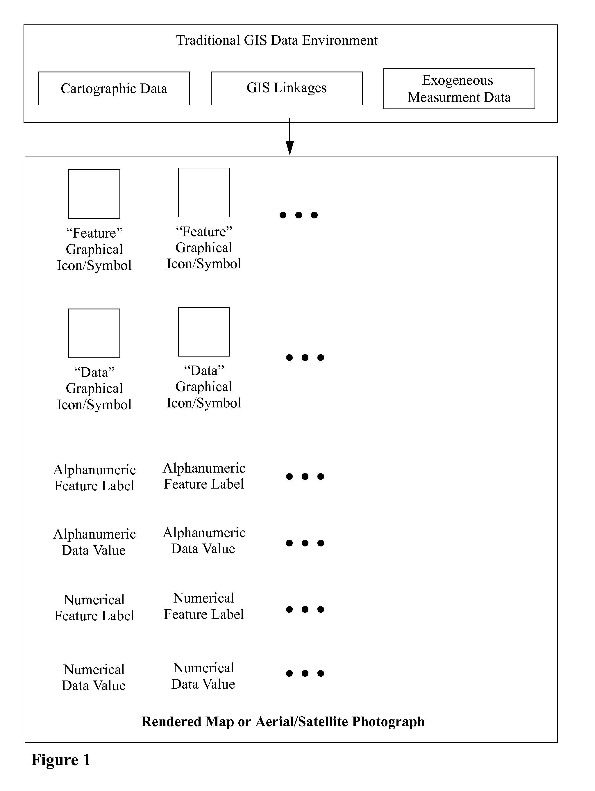
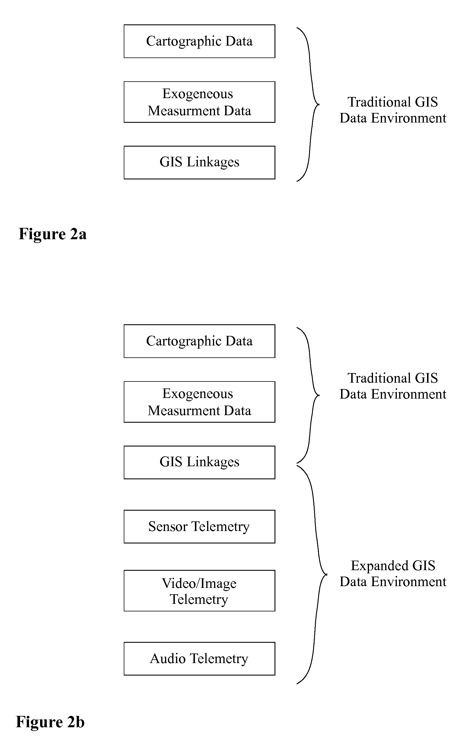
[0099]FIG. 1 depicts an exemplary representation of an exemplary traditional GIS system. Here cartographic data, GIS linkages, an exogenous measurement data provide an exemplary traditional GIS data environment. The data in this data environment can be used to populate a vector-graphic map or overlay a raster image map (graphically produced, aerial photograph, satellite image, etc. with additional icons, symbols, te...


PUM


Abstract

An advanced Geographic Information System (GIS) providing modeling, analysis, Multicriteria Decision Analysis (MCDA), data visualization, data sonification, web interface, risk management, sensitivity analysis, and telemetry capabilities is described. Telemetry can be provided by field sensors, field video, and/or field audio, and can be recorded or provided live in either direct or analyzed form. Data visualizations can be displayed along with GIS graphics, and can be superimposed or otherwise integrated with GIS graphics. GIS graphics can be used as the basis for an interactive user interface for other parts of the system. Web interfaces can support remote use, server based implementations, and/or collaboration. Advanced multi-channel data sonification can be used to prevent visual overloading of GIS graphics and interactions with it. The system can include rich data processing capabilities and interconnections of these so as to facilitate powerful data visualization and sonification results and can support multidimensional user interface devices.

Description

CROSS-REFERENCE TO RELATED APPLICATIONS[0001]This application claims benefit of priority of U.S. provisional application Ser. No. 61 / 268,873 filed on Jun. 16, 2009, and U.S. provisional applications Ser. No. 61 / 239,426 and 61 / 239,428, both filed Sep. 2, 2009. All three provisional applications are incorporated herein by reference.BACKGROUND OF THE INVENTION[0002]1. Field of the Invention[0003]The present invention generally relates to a spatial information system, such as geographic information system (GIS) provided with additional features motivated by the cited problems and observations.[0004]2. Background of the Invention[0005]A geographic information system (GIS), also referred to as a geographical information system, is in the broadest sense any system that captures, stores, analyzes, manages, and presents data that are linked to a geographic location. In among the simplest terms, GIS is the merging of cartography and database technology. GIS systems are used in cartography, re...

Claims


Application Information

Patent Timeline
Patent Type & Authority Applications(United States)
IPC IPC(8): G06F17/30
CPCG06F17/30241G06F16/29
Inventor LUDWIG, LESTER F.
Owner NRI R&D PATENT LICENSING LLC
Why Eureka
Try Eureka