Car Navigation System, Program and Method for Updating Map Data

a technology for updating map data and navigation system, which is applied in the direction of traffic control system, navigation instruments, instruments, etc., can solve the problems of long distribution and update time, inefficient way to update map data via portable media, and difficulty in keeping up with the changes of a road map caused by daily road construction and repairs

Inactive Publication Date: 2010-12-30
CLARION CO LTD
View PDF10 Cites 28 Cited by
  • Summary
  • Abstract
  • Description
  • Claims
  • Application Information

AI Technical Summary

Benefits of technology

[0018]Accordingly, an object of the present invention is to provide a car navigation system, a program and a method for updating map data that ensures a normal operation of the car navigation functions even when updating map data is in progress, and making the updated map data usable quickly.
[0024]As stated above, in the present invention, each application program in the car navigation system specifies a map data file necessary for the execution of the application program, and monitors the update status of the identified map data file. Accordingly, it is possible to execute the application program normally when the map data file necessary for the execution of the application program is updated, without waiting for all map data files to be updated.
[0025]In addition, in the present invention, since the identified map data file is updated associating with the execution status of the application program, it is possible to ensure the normal operation of the car navigation system.
[0026]The present invention provides normal operation of the car navigation system even when update of the map data is in progress, and makes the updated map data usable quickly.

Problems solved by technology

However, considering the fact that data to be updated is usually at most a few percents of the total map data, it is not an efficient way to update map data via portable media.
In addition, in such a method using portable media, it is difficult to keep up with the changes in a road map caused by daily road constructions and repairs.
Furthermore, provision of such new map data becomes available usually at most once a year, and as a result, considerable number of places include deviation between map data in a car navigation system and the actual road conditions.
However, in the case of distributing map difference data, since communications and broadcasting are used as a distribution means, it takes long time for the distribution and update despite using difference map data to reduce the data size.
However a problem is still remained that it takes long time before new map data becomes usable.
In addition, since it uses map data before update when updating map data is in progress, there is a possibility of displaying guidance information that does not match the real situation.
According to the car navigation system disclosed in JP2003-315056, there is a possibility of mismatches between data near the border of updated map data and the adjacent map data that is not updated yet, causing inconsistency between displayed map data and route guidance data.
As stated above, in conventional techniques, it is difficult to satisfy both of, making the updated map data to be usable rapidly, and performing a route search and displaying guidance data without inconsistency using map data before update and map data after update.

Method used


Image

  • Car Navigation System, Program and Method for Updating Map Data
  • Car Navigation System, Program and Method for Updating Map Data
  • Car Navigation System, Program and Method for Updating Map Data

Examples


Embodiment Construction

[0048]An embodiment of the present invention will be explained in detail by referring to figures, as needed.

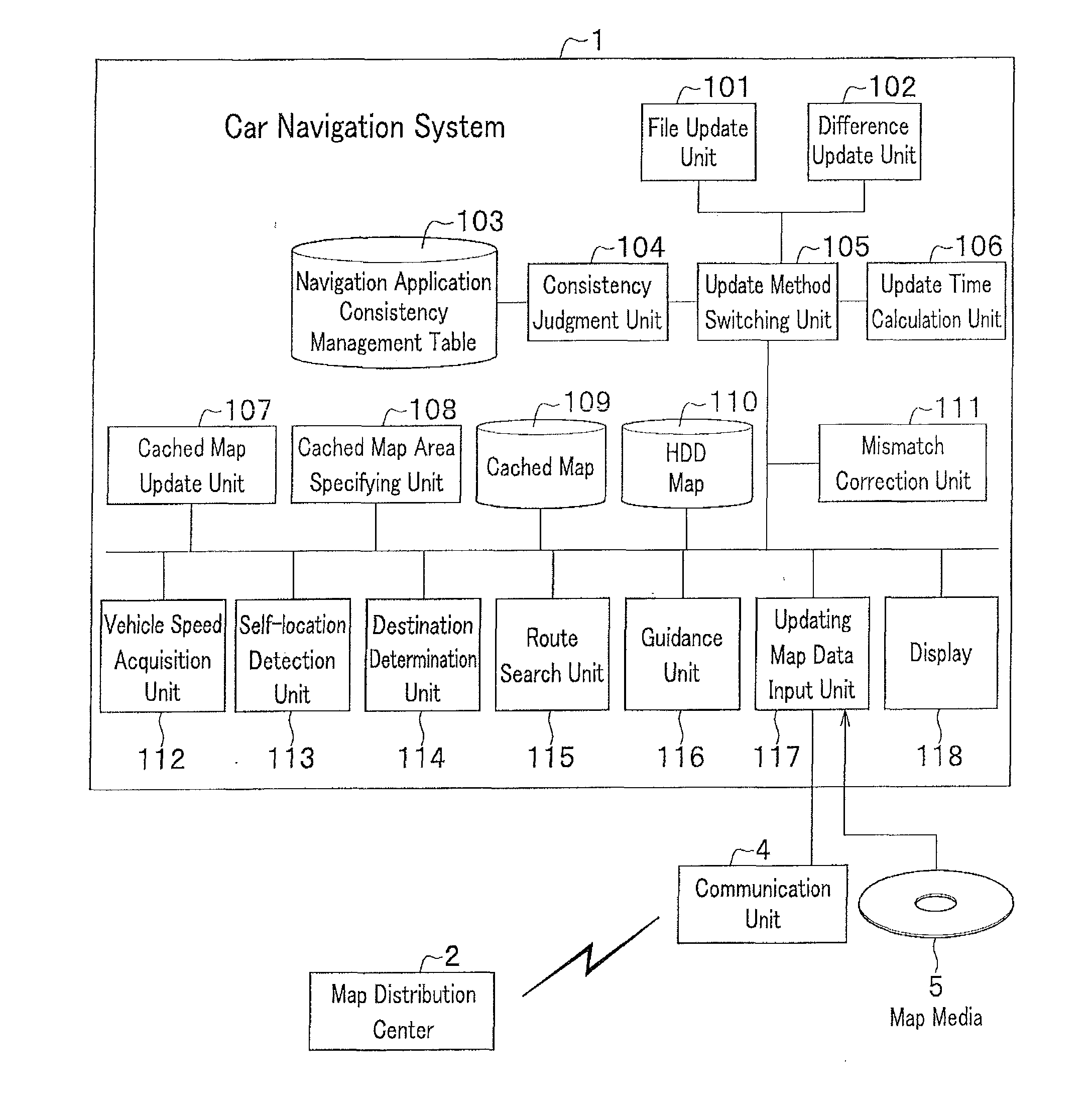
[0049]FIG. 1 shows a functional block diagram of a car navigation system in accordance with an embodiment of the present invention.

[0050]As shown in FIG. 1, the car navigation system 1 is equipped with an HDD map 110 including a map database, and for implementing so called navigation functions the car navigation system 1 is also equipped with function blocks such as: a vehicle speed acquisition unit 112 for acquiring a vehicle speed, a self-location detection unit 113 for detecting a self-location by specifying latitude / longitude via radio waves sent from a GPS satellite, a destination determination unit 114 for setting a POI selected by a user as a destination, a route search unit 115 for performing a route search from the self-location to the destination, a guidance unit 116 for performing guidance of intersections based on the result of the route search, a display 118 for d...


PUM


Abstract

A car navigation system 1 includes a HDD map 110 and a cached map 109. Map data for entire area is stored in the HDD, and map data used by a route search unit 115 and a guidance unit 116 are stored in the cached map 109. A cached map area specifying unit 108 specifies map data files that should be stored in the cached map 109 for each navigation application, and stores the names of the specified map data files, linked to the respective navigation applications, into a navigation application consistency management table 103. A consistency judgment unit 104 monitors an update status of a data file of which name stored in the navigation application consistency management table 103, and stores the update status (completed or not completed) into the navigation application consistency management table 103.

Description

CROSS REFERENCE TO RELATED APPLICATION[0001]The present application claims benefit of the filing dates of Japanese Patent Application No. 2009-151997 filed on Jun. 26, 2009, which is incorporated herein by reference.BACKGROUND OF THE INVENTION[0002]1. Field of the Invention[0003]The present invention relates to a car navigation system and a program thereof, and a method for updating map data used in the car navigation system.[0004]2. Description of the Related Art[0005]In recent years, navigation systems for vehicles driving on a road (hereinafter referred to as “car navigation system”) have been used in all over the world.[0006]A car navigation system locates a self-location based on map data stored in a Hard Disk Drive (HDD) etc. and latitude / longitude data acquired via radio waves sent from a Global Positioning System (GPS) satellite, and displays a map of the located self-location and its vicinity on a display.[0007]In addition, a car navigation system performs a route search fr...

Claims


Application Information

Patent Timeline
Patent Type & Authority Applications(United States)
IPC IPC(8): G01C21/36
CPCG01C21/32G01C21/34G06F16/29G01C21/3859
Inventor TOMOBE, OSAMUKAWAMATA, YUKIHIROSASAKI, HIROTOUCHIDA, TAKAYUKIAIKAWA, TETSUMORI
Owner CLARION CO LTD
Why Eureka
Try Eureka