Method and apparatus for processing traffic information based on intersections and sections

a technology of intersections and sections, applied in the field of traffic information data processing, can solve the problems of increasing traffic jams, limited to arterial road networks in general, and subject to objective constraints such as the number of probe vehicles

Inactive Publication Date: 2011-06-30
NEC (CHINA) CO LTD
View PDF25 Cites 46 Cited by
  • Summary
  • Abstract
  • Description
  • Claims
  • Application Information

AI Technical Summary

Benefits of technology

[0014]Furthermore, by using the road network represented by intersections and sections, an ordinary city map, a navigation road topology network and traffic information data in text which are generally used in collection of the traffic information can be converted into unified traffic information data of intersections and sections for data fusing and subsequent using. As compared to the traffic information data modeling method in the prior art, the present invention emphasizes the effect of intersections as independent nodes of road network in obtaining and rendering information. Intersection is a geographical space which is expressed as a node in the road network, and intersection is also a hub of the network which tends to be congested because traffic flow in each direction influx to this single location. Therefore, road conditions of intersections are very important in the traffic information. In the method of the present invention, intersection is considered as an independent element for modeling the traffic data, different turn relationships of an intersection are extracted, and the traffic condition of the intersection is analyzed. Furthermore, a section is a road segment between adjacent intersections along a road. In this manner, the whole road topology network is composed of sections and intersections in the sense of geographical space, and traffic information is expressed with sections and intersections.

Problems solved by technology

In modern society, automobiles are becoming increasingly widespread with the rapid economic growth, which imposes more and more pressures on urban traffic and causes increasingly severe traffic jams.
In traffic information gathering, stationary probing devices deployed along the roads, such as cameras, loops and RTMS (Remote Traffic Microwave Sensor), can accurately gather data for traffic information, which is, however, limited to arterial road network in general.
The probe vehicle technology, which mainly uses taxies, can calculate traffic information for urban road network in real time, but it is subjected to objective constraints such as the number of probe vehicles.
In this case, however, information is limited in amount and also is inaccurate.
A user uploading approach, in which a driver uploads traffic information for the area where he / she is currently located to a data center via a channel provided by a mobile information service provider, suffers from limited coverage.
However, these approaches have different types of data formats, different description fashions and respective drawbacks in information completeness and accuracy.
Further, there are overlapping portions between road sections of different flow directions, which will cause a problem of decreased accuracy.
The importance of intersections in the traffic network is not considered in this method, either, and the traffic information of the road can not be obtained from this method.
Although this method tries to describe the traffic information in a manner more conform to people's daily life language, it is limited to text form, and can not be mapped to different geographical networks or used in fusion of data from multiple sources.
As mentioned above, the conventional traffic information modeling or representing methods still have shortcomings, and fail to establish a model for traffic information modeling from the perspective of universality and practicality.

Method used


Image

  • Method and apparatus for processing traffic information based on intersections and sections
  • Method and apparatus for processing traffic information based on intersections and sections
  • Method and apparatus for processing traffic information based on intersections and sections

Examples


Embodiment Construction

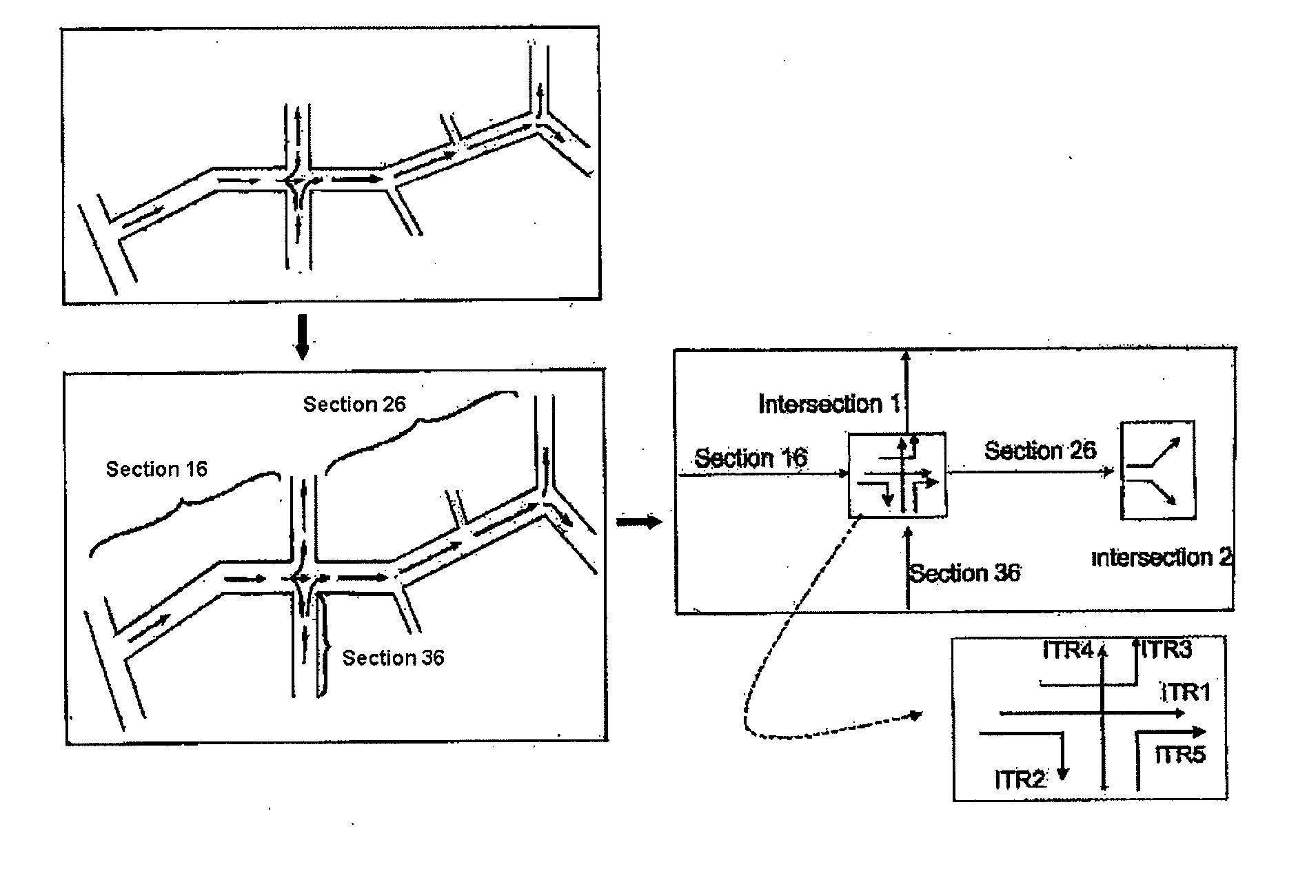
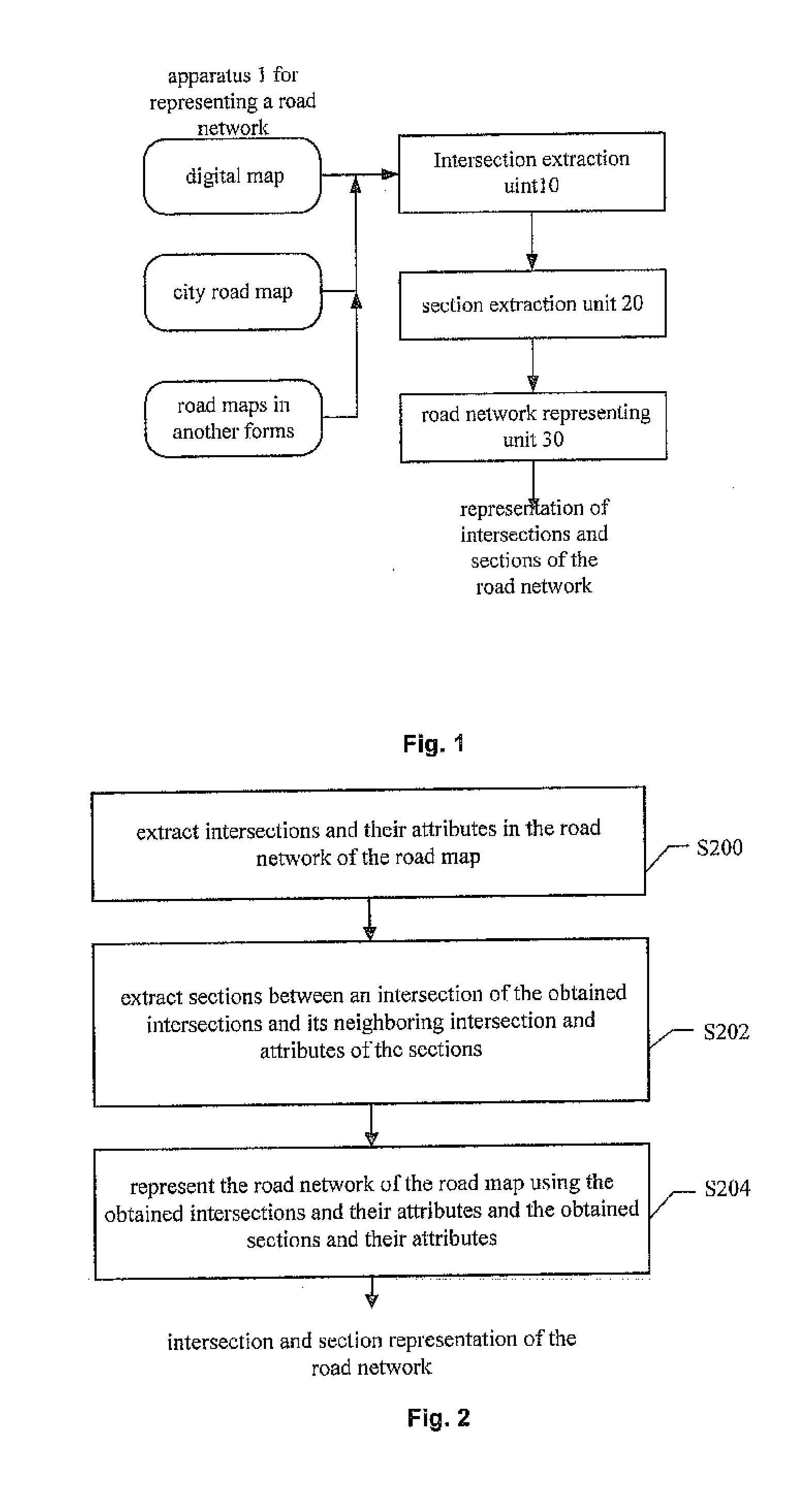
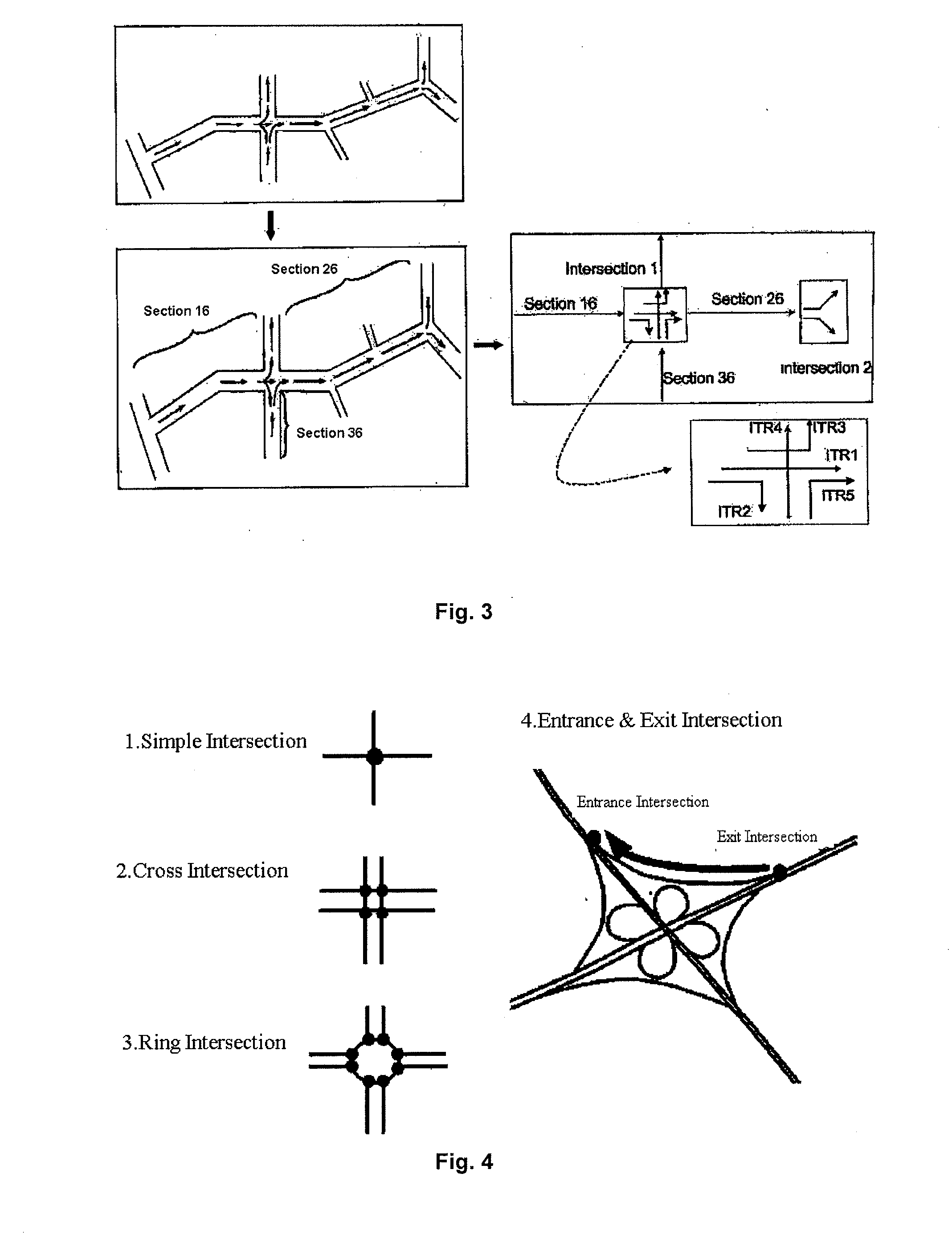
[0034]There are various data sources for traffic information, for example, stationary monitor devices such as a Remote Traffic Microwave Sensor, a loop or a camera etc., mobile detecting devices such as probe vehicle network or mobile communication subscriber networks, and text information such as traffic condition reports from the traffic office, information reports from information collector personnel, instantaneous upload from users. The traffic information provided by these data sources may be based on a simple city map, or may be based on a complex road topology network of navigation digital map, or may be completely based on text description. Complexities and constituents of the road networks in road maps may differ from each other, and it is generally difficult to determine associations between the traffic information pieces based on different road maps. Additionally, it is more difficult to determine associations between traffic information described in text and traffic info...


PUM


Abstract

A method and apparatus for representing a road network and a method and system for processing traffic information data using the method for representing a road network are provided. The method for processing traffic information data comprises: conversion step of converting traffic information data based on road networks of one or more types of road maps into traffic information data of intersections and sections, based on correspondence between the road networks of one or more types of road maps and the road network represented by the intersections and the sections, wherein the road network represented by the intersections and the sections is obtained by the method for representing a road network; and fusion step of fusing the converted traffic information data of intersections and sections to obtain unified traffic information data. The present invention proposes using a road network represented by intersections and sections as an intermediate model, which emphasizes the importance of intersections as hub nodes of the road network, and is compatible with various forms of map representations and universal. In this way, more accurate and comprehensive information can be obtained by fusing traffic information data from different data sources, which is advantageous for services such as traffic information prediction.

Description

FIELD OF INVENTION[0001]The present invention relates to traffic information data processing, in particular to a representation of a road network based on intersections and sections, and processing of traffic information data from various data sources by using the representation.DESCRIPTION OF PRIOR ART[0002]In modern society, automobiles are becoming increasingly widespread with the rapid economic growth, which imposes more and more pressures on urban traffic and causes increasingly severe traffic jams. It is advantageous to mitigate traffic congestions, so as to reduce travel time for automobile drivers, reduce fuel consumption, improve economic efficiency of a city and facilitate environment protection. Thus, the traffic information service system plays an important role in urban intelligent traffic system.[0003]With respect to traffic information gathering, the current rapid development of multi-media technology, mobile communication technology and the popularization of GPS tech...

Claims


Application Information

Patent Timeline
Patent Type & Authority Applications(United States)
IPC IPC(8): G08G1/00G01C21/36G06K9/00
CPCG08G1/0104
Inventor WU, TAOHU, WEISONGLIU, XIAOWEIWANG, SHAOYALI, CHENGHAIZHANG, WEILI
Owner NEC (CHINA) CO LTD
Why Eureka
Try Eureka