
Adjusting a level of map detail displayed on a personal navigation device according to detected speed

Active Publication Date: 2011-07-14
MITAC INT CORP
View PDF11 Cites 26 Cited by
  • Summary
  • Abstract
  • Description
  • Claims
  • Application Information

AI Technical Summary

Benefits of technology

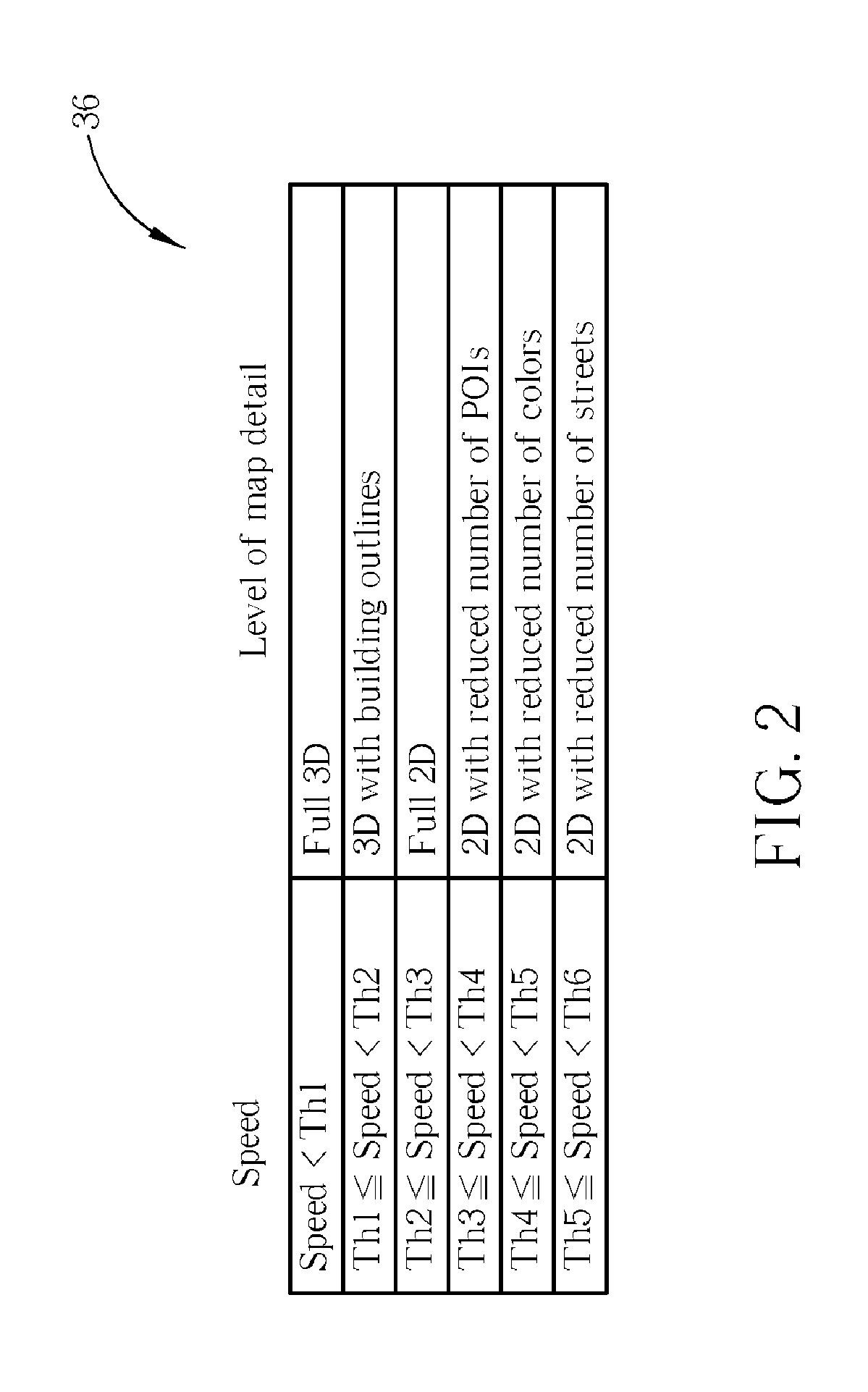
[0011]It is an advantage that the present invention provides a way to automatically adjust the level of map detail shown on the personal navigation device so that users can see more detail when it is useful at slower speeds and see less detail when driving at high speeds. In this way, the present invention shows a level of map detail that is appropriate for the way that the personal navigation device is being used. Pedestrians and slow moving vehicles can make use of 3D views, whereas fast moving cars can utilize a simple and uncluttered 2D view.

Problems solved by technology

When driving in a car, however, 3D maps can obscure the map view by covering up the upcoming roads and points of interest.

Method used


Image

  • Adjusting a level of map detail displayed on a personal navigation device according to detected speed
  • Adjusting a level of map detail displayed on a personal navigation device according to detected speed
  • Adjusting a level of map detail displayed on a personal navigation device according to detected speed

Examples


Embodiment Construction

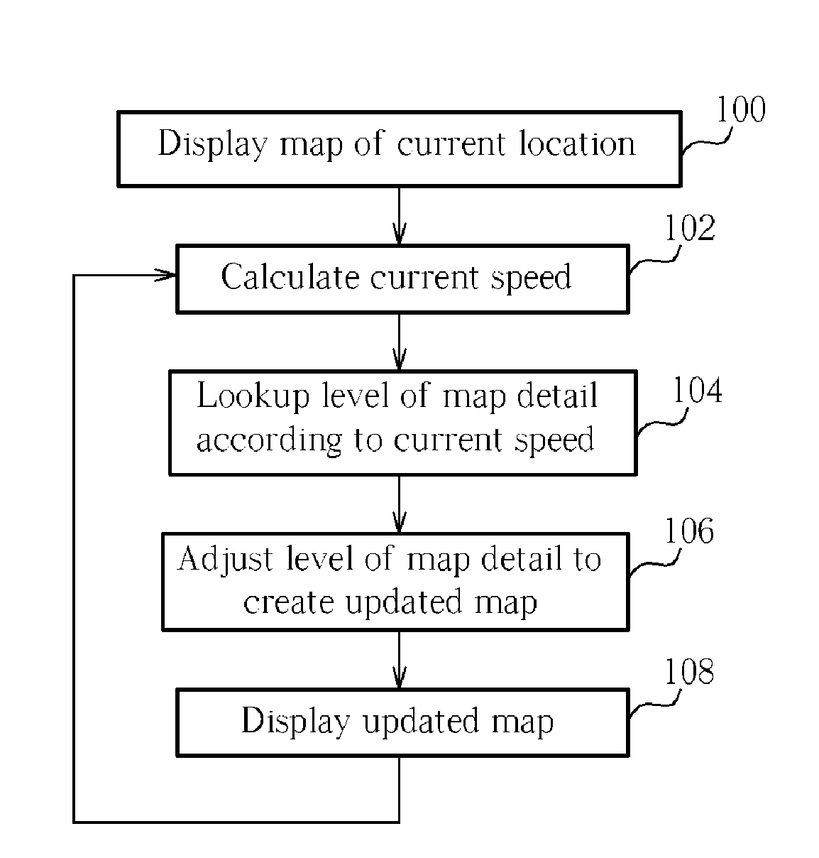
[0016]The present invention provides a way to automatically adjust the map information displayed on a personal navigation device. The personal navigation device can zoom in on a map when moving at slow speeds, and can zoom out when moving at fast speeds. In addition, 3D maps can be shown at slower speeds, while 2D maps can be shown at faster speeds, with the maps becoming simpler and less cluttered as the driving speed increases.

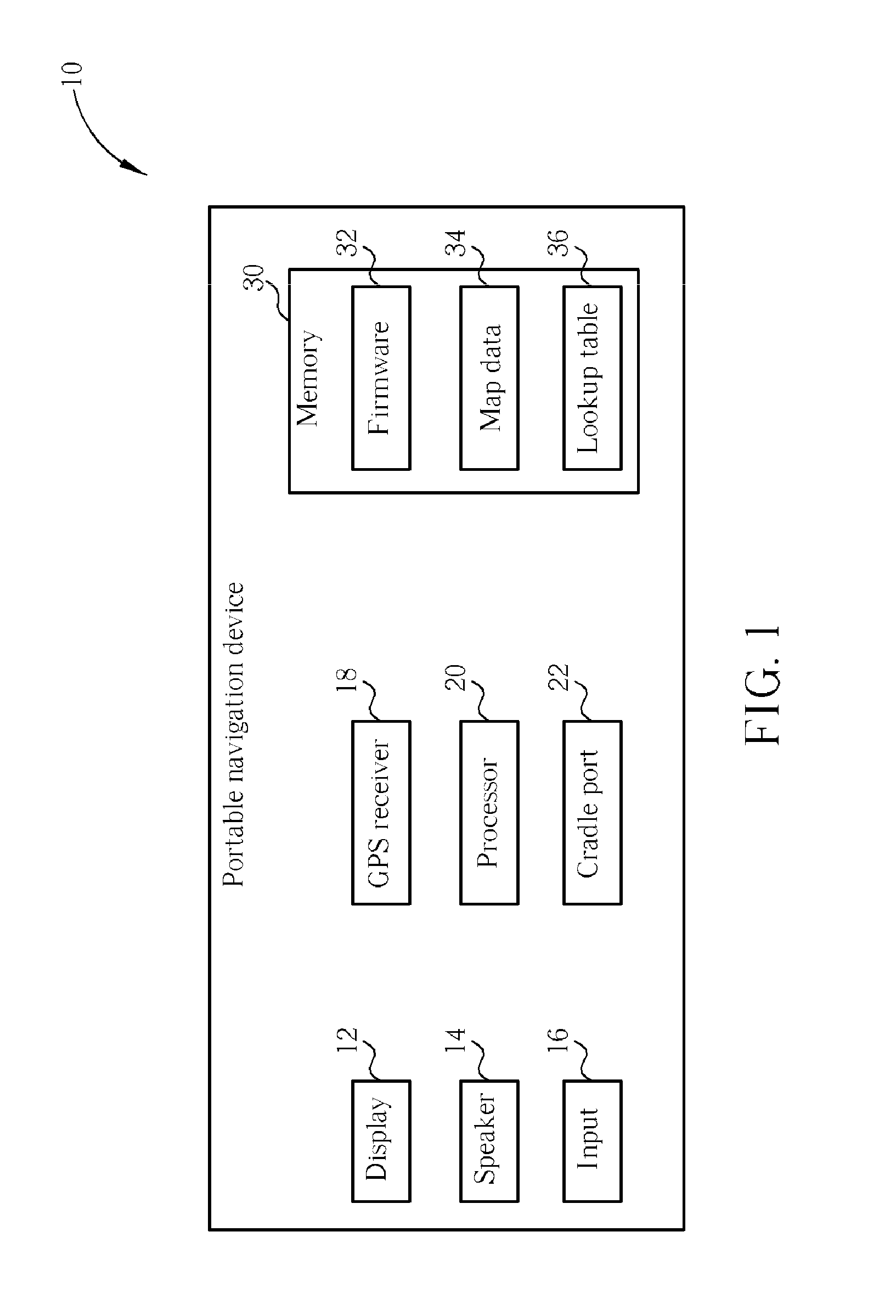
[0017]Please refer to FIG. 1. FIG. 1 is a block diagram of a personal navigation device 10 according to the present invention. The personal navigation device 10 contains a display 12 for showing map and route data to a user, a speaker 14 for outputting audible alerts to the user, and input 16 such as control buttons and a touch-screen. The personal navigation device 10 also contains a GPS receiver 18 for receiving the current location of the personal navigation device 10 such as the latitude and longitude coordinates. A processor 20 controls operation of the...


PUM


Abstract

A method of adjusting a level of map detail for content displayed on a personal navigation device includes displaying a map of a current location of the personal navigation device on a display of the personal navigation device, calculating a current speed of the personal navigation device, adjusting a level of map detail according to the current speed of the personal navigation device to create an updated map, and displaying the updated map on the display of the personal navigation device.

Description

BACKGROUND OF THE INVENTION[0001]1. Field of the Invention[0002]The invention relates to a method of display map data on a personal navigation device, and more particularly, to a method and related device for adjusting a level of map detail shown on the personal navigation device according to a current speed of the personal navigation device.[0003]2. Description of the Prior Art[0004]Global Positioning System (GPS) based navigation devices are well known and are widely employed as in-car navigation devices. Common functions of a navigation device include providing a map database for generating navigation instructions that are then shown on a display of the navigation device. These navigation devices are often mounted on or in the dashboard of a vehicle using a suction mount or other mounting means.[0005]The term “navigation device” refers to a device that enables a user to navigate to a pre-defined destination. The device may have an internal system for receiving location data, such...

Claims


Application Information

Patent Timeline
IPC IPC(8): G01C21/26G06T5/00G06T15/00
CPCG01C21/367
Inventor MUZINA, HRVOJEROSSER, HAYDEN JAMES
Owner MITAC INT CORP
Learn More