Satellite Tracking Method and Apparatus Thereof

a satellite and satellite technology, applied in the field of satellite communication systems, can solve the problems of reducing the frequency of course corrections of satellite operators, reducing the cost of building and launching new geostationary satellites, and not being stationary at all, so as to minimize the effect of signal reception level degradation, improving peaking process, and minimizing the effect of ground station performan

Inactive Publication Date: 2012-01-19
GILAT SATELLITE NETWORKS
View PDF1 Cites 16 Cited by
  • Summary
  • Abstract
  • Description
  • Claims
  • Application Information

AI Technical Summary

Benefits of technology

[0015]In one aspect of the invention, the controller of the tracking antenna may be configured to use a method for tracking an inclined orbit geostationary satellite, the method comprising a learning step and a tracking step. During the learning step, the controller may be configured to create a table including information corresponding to the satellite's inclination path, by perform a peaking process at constant predetermined intervals over a period of a full inclination cycle, storing the peaking results and applying a filter to these results for at least the purpose of reducing alignment errors. During the tracking step, at constant intervals, the controller may be configured to calculate an antenna position using the filtered table and to command the motor for at least the purpose of moving the antenna to the calculated position.
[0017]In another aspect of the invention, an improved peaking process is presented. By combining a peaking process with said tracking method previously mentioned and in particularly with said filtering of the acquired table, the improved peaking process may be used for at least the purpose of minimizing the degradation in signal reception level during peaking and consequently minimizing the effect on the ground station's performance.

Problems solved by technology

However, geostationary satellites are actually not stationary at all but rather very much in motion.
Unfortunately, course-correction engines of geostationary satellites run on fuel (gas).
However, since building and launching new geostationary satellites is very expensive (usually in the hundreds of millions of USD per satellite), operators of geostationary satellites try to prolong the use of already deployed satellites before replacing them with new ones.
Thus, as a geostationary satellite runs out of fuel (leaving little fuel for taking the satellite out of orbit when it is no longer usable), the satellite operator reduces the frequency of course corrections and ultimately stops making them altogether.
However, some communication systems operators may opt to using the more expensive equipment since the satellite capacity is usually sold at lower prices (to balance the higher cost of equipment) and due to capacity shortage over properly positioned satellites.
However, the existing methods used for tracking inclined orbit satellites have deficiencies.
However, in order to achieve accurate alignment (i.e. pointing the exact center of the antenna beam towards the satellite with minimal alignment error), the antenna must be moved quite significantly away from the center position, causing perhaps significant deterioration in reception quality of received signals.
On one hand, if the peaking process is done with a purpose to yield a highly accurate result and / or a minimal alignment error, the antenna must be moved over a relatively large range, hence the process may take considerable time to complete and during which service at the ground station is significantly affected (i.e. as moving further away from the center position further decreases at least the reception level).
Moreover, during that time the satellite keeps moving, i.e. the longer it takes to complete the process the further the satellite may move and the larger the resulting alignment error may get after all.
On the other hand, if the peaking process is shortened and the search is limited to a smaller range, the resulting antenna alignment is likely to be less than optimal and include a significant alignment error.
This alignment error reduces overall performance of the ground station (as at least the reception quality is less than optimal) and increases the probability for needing to repeat the peaking process thereafter (hence further causing performance degradation as well as expediting wear processes of motors and moving parts, which results in higher maintenance costs).

Method used


Image

  • Satellite Tracking Method and Apparatus Thereof
  • Satellite Tracking Method and Apparatus Thereof
  • Satellite Tracking Method and Apparatus Thereof

Examples


Embodiment Construction

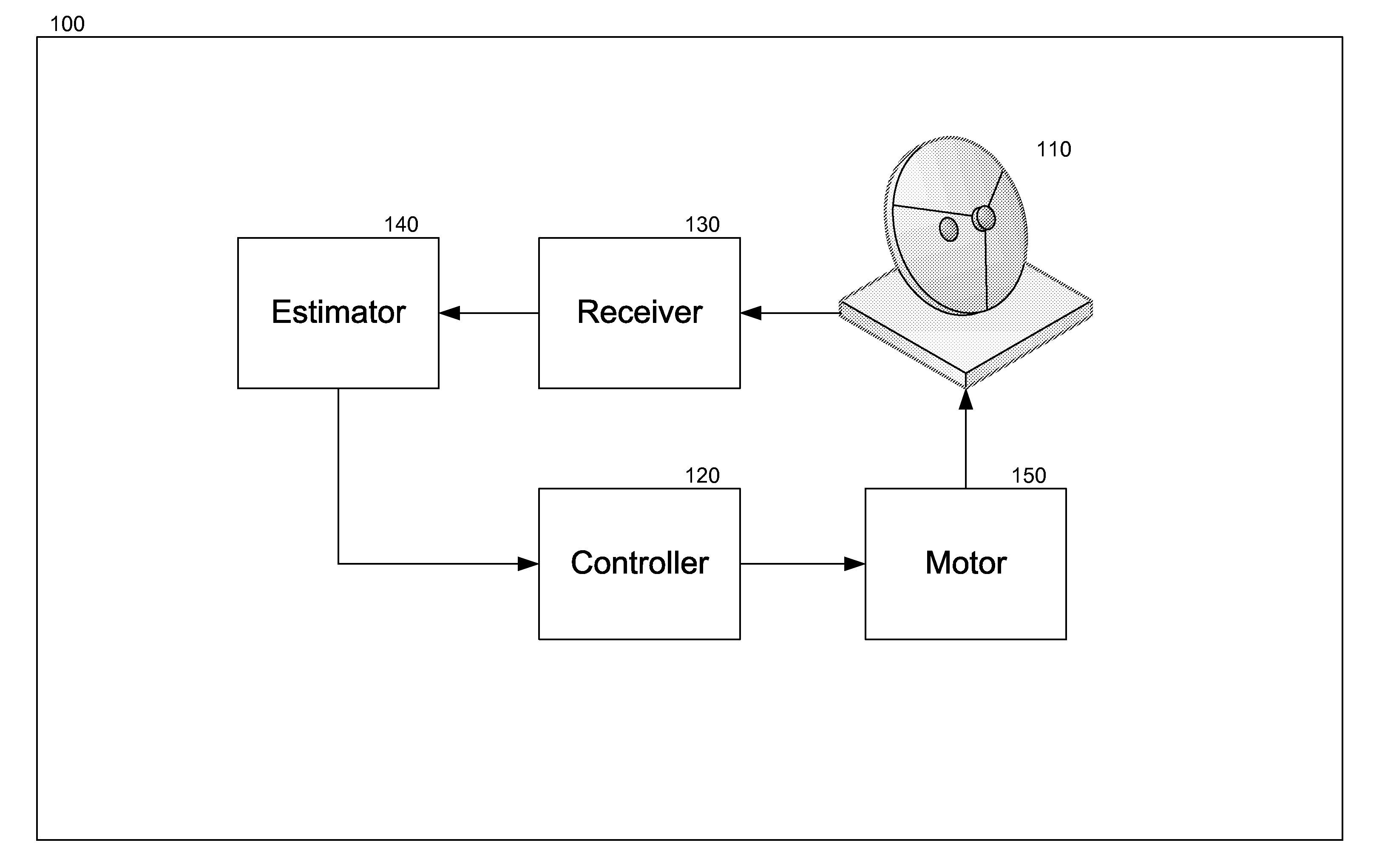
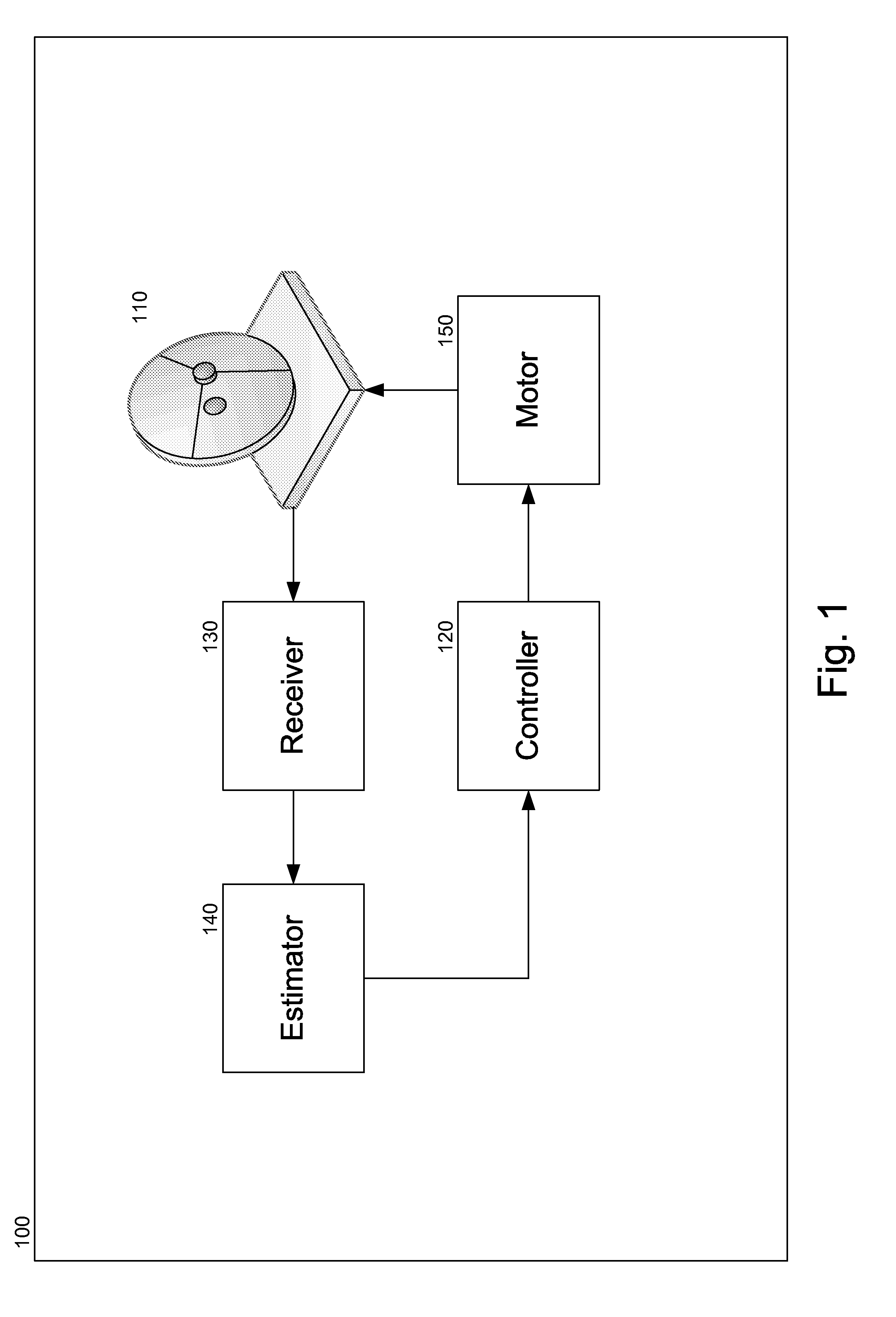
[0023]Referring to FIG. 1, a satellite communication ground station 100 may be configured for communicating over an inclined orbit geostationary satellite. Ground station 100 may include a tracking antenna 110 configured to have three (3) fixed axis (azimuth, mount elevation and polar) and one moving axis. Motion around the forth axis (inclination axis) may be controlled by a motor 150, wherein the motor operation may be further controlled by a controller 120. Ground station 100 may further include a receiver 130, which may be configured to at least receive a signal arriving from the satellite via tracking antenna 110, and an estimator 140, which may be configured to at least estimate reception quality of a signal received by receiver 130 and provide the estimation to controller 120.

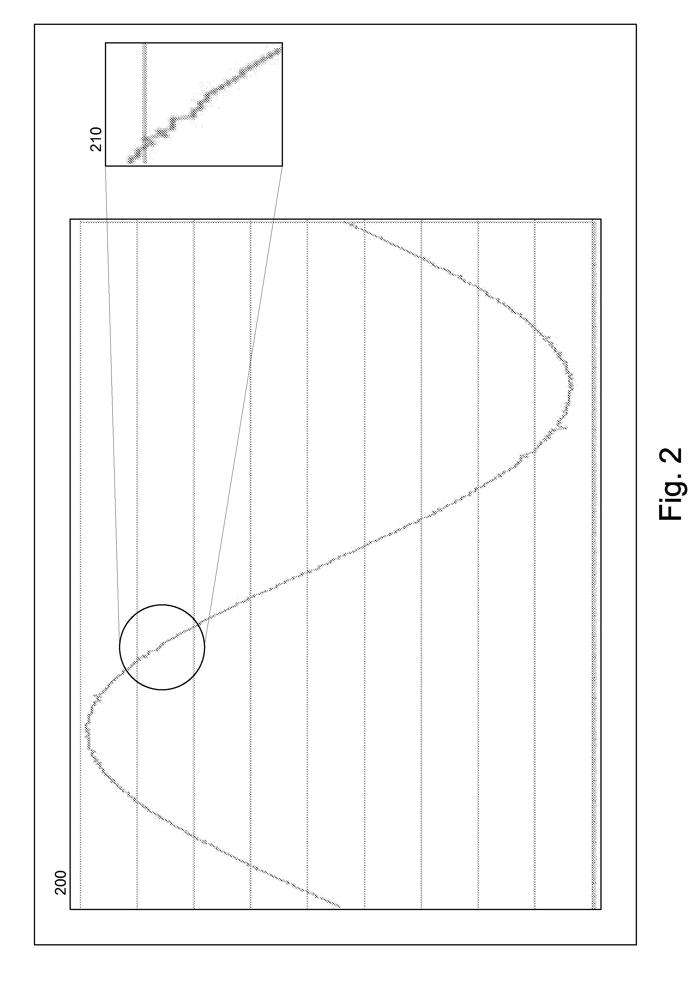
[0024]When all three fixed axis of tracking antenna 110 are properly aligned, the center of the antenna beam may be pointed at the satellite's nominal position on the orbital arc, i.e. at the point where...


PUM


Abstract

A satellite communication ground station configured for communicating over an inclined orbit geostationary satellite may include a tracking antenna having three fixed axis and one moving axis, a motor for swinging the antenna along the moving axis, a controller for controlling the motor, a receiver configured to receive a signal arriving from the satellite via the tracking antenna and an estimator configured to estimate reception quality of a signal received by the receiver. The invention described herein presents a method for tracking an inclined orbit geostationary satellite, the method comprising a learning step and a tracking step, wherein the learning step includes use of a filter for reducing alignment errors and reducing the amount of peaking required for aligning the antenna with the satellite and tracking its movement.

Description

RELATED APPLICATIONS[0001]The present application is a non-provisional of U.S. Patent Application No. 61 / 363,869, entitled “Satellite Tracking Method and Apparatus Thereof,” filed Jul. 13, 2010, the contents of which are incorporated herein by reference in their entirety for all purposes.FIELD OF THE INVENTION[0002]This invention pertains to the field of satellite communication systems. In particular, this invention pertains to methods and systems for tracking inclined orbit satellites.BACKGROUND[0003]Systems for communication via satellites are well known in the art and have been used in many applications for several decades. Many of these systems use geostationary satellites, i.e. satellites seen at fixed positions in the sky relative to the earth due to being located at the Clark Belt (i.e. approximately 36,000 kilometers above the earth's equator, where the angular velocity of the satellite matches the angular velocity of the earth rotation around its axis). As these satellites ...

Claims


Application Information

Patent Timeline
Patent Type & Authority Applications(United States)
IPC IPC(8): H01Q3/00
CPCB64G3/00H01Q3/06H01Q1/1257
Inventor HALAVI, MOSHEPELED, HAGAYBERGER, ADI
Owner GILAT SATELLITE NETWORKS
Why Eureka
Try Eureka