3D layering of map metadata

a map metadata and 3d technology, applied in the direction of navigation instruments, vehicle position indications, instruments, etc., can solve the problems of excessive visual complexity, viewer lose context during transitions, disorientation, etc., and achieve smooth motion effects for zooming in and improving the overall experience of using map navigation tools

Active Publication Date: 2012-01-26
MICROSOFT TECH LICENSING LLC
View PDF7 Cites 106 Cited by
  • Summary
  • Abstract
  • Description
  • Claims
  • Application Information

AI Technical Summary

Benefits of technology

[0004]Techniques and tools are described for rendering views of a map in which map metadata elements are layered in three-dimensional (“3D”) space through which a viewer navigates. Layering of map metadata elements in 3D space facilitates smooth motion eff...

Problems solved by technology

This can cause excessive visual complexity due to the density of information that needs to be displayed at an...

Method used


Image

  • 3D layering of map metadata
  • 3D layering of map metadata
  • 3D layering of map metadata

Examples


example map metadata

Elements with Different Altitudes in 3D Space

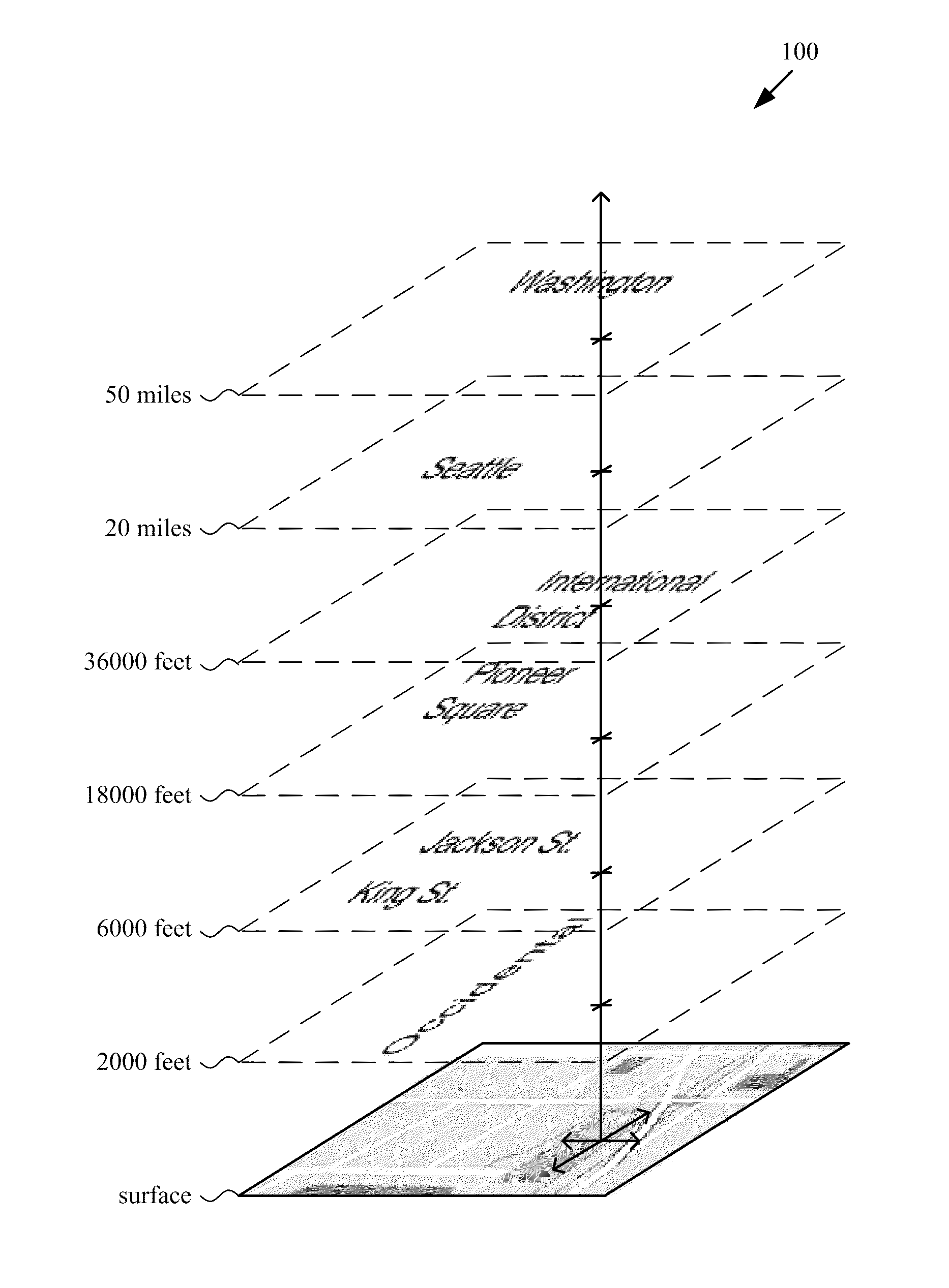
[0028]In conventional map views presented by map navigation tools, the density of metadata presented on a map view can create visual complexity. Selectively hiding and revealing map metadata in different views can help limit the density of metadata presented, but transitions between different views are problematic. Techniques and tools described herein layer map metadata elements according to altitude in a 3D space. This 3D layering provides a natural hierarchy of map metadata for rendering. It also provides a straightforward way to relate viewer position to the selection of which map metadata elements to hide or reveal when rendering a map view.

[0029]FIG. 1 shows an example of map metadata (100) with different altitudes in 3D space. The map metadata (100) are text labels that appear above a surface layer with details of roads and other geographic features. Different metadata text labels have different altitudes associated with them in 3D...

example rendering

of Map Metadata Elements with Different Altitudes in 3D Space

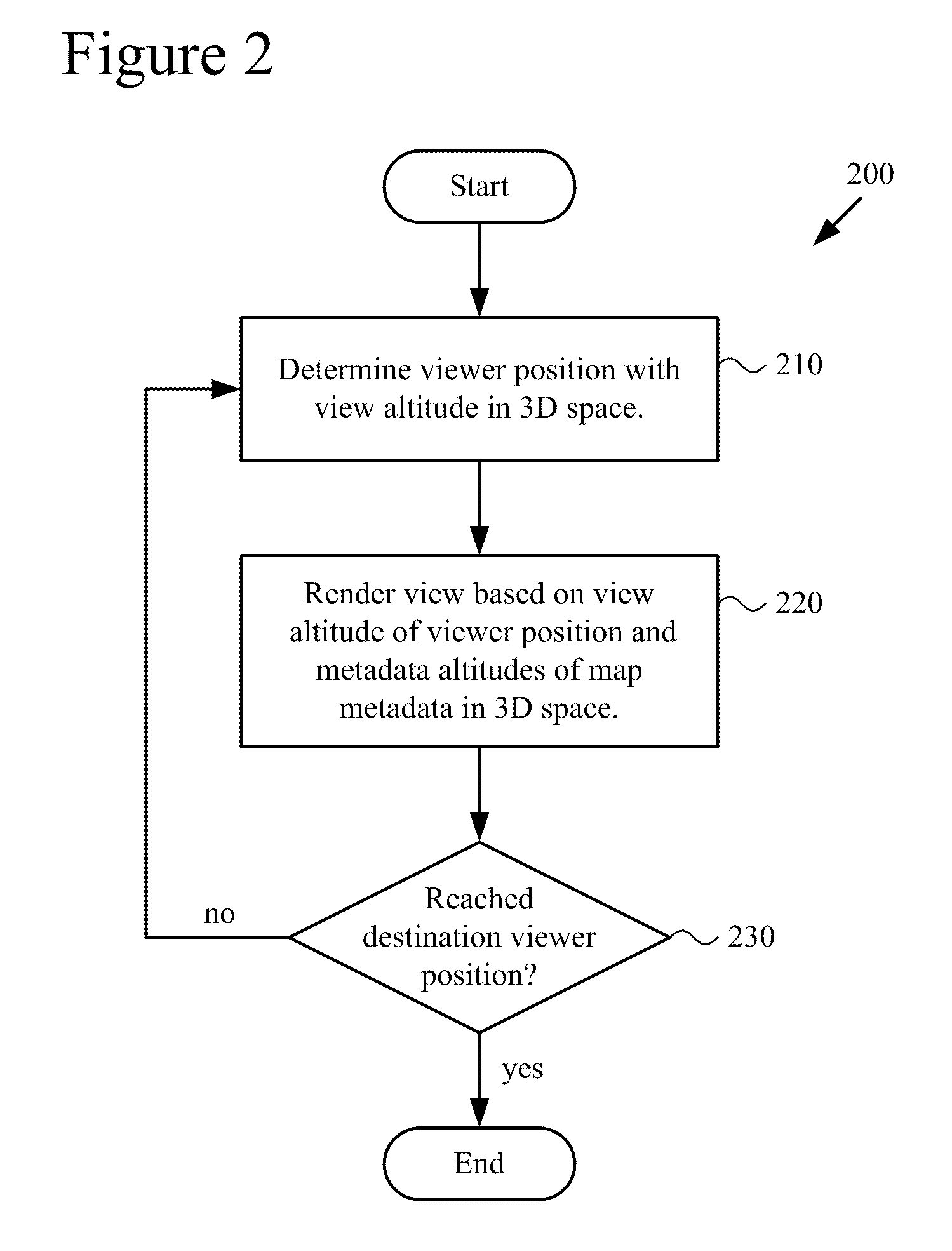
[0037]FIG. 2 shows a generalized technique (200) for rendering map views that depend on viewer position and different altitudes of map metadata elements in 3D space. A tool such as a mobile computing device or other client computing device can perform the technique (200).

[0038]To start, the tool determines (210) a viewer position associated with an altitude in 3D space (here, the view altitude, or altitude of the viewer position). For example, the viewer position is initially a default viewer position, the last viewer position reached in a previous navigation session, a previously saved viewer position, or a viewer position indicated as the result of a search. In subsequent iterations, the viewer position can be a destination viewer position in 3D space or an intermediate viewer position between the previous viewer position and a destination viewer position in 3D space.

[0039]The tool renders (220) a view of the map for dis...

example scrolling

Navigation with Parallax Effects

[0057]FIGS. 6a-6d show example map views (610, 620, 630, 640) as geographic position changes during navigation over map metadata text labels at different metadata altitudes in 3D space. In particular, for the navigation illustrates in FIGS. 6a-6d, the altitude of the viewer position is essentially unchanged, but the geographic position moves north / northeast. Parallax effects are exhibited for metadata text labels, which stay in place in 3D space over the features they mark, but appear to move between the map views (610, 620, 630, 640) of FIGS. 6a-6d.

[0058]The map view (610) of FIG. 6a shows a metadata text label for Montlake, for example, that appears over a highway. As the viewer moves north / northeast, the position of the label for Montlake appears to move south / southwest between the map views (620, 630, 640) of FIGS. 6b-6d. Some other metadata text labels exhibit parallax effects to a greater or less extent. For example, the metadata text label for...


PUM


Abstract

Techniques and tools are described for rendering views of a map in which map metadata elements are layered in 3D space through which a viewer navigates. Layering of metadata elements such as text labels in 3D space facilitates parallax and smooth motion effects for zoom-in, zoom-out and scrolling operations during map navigation. A computing device can determine a viewer position that is associated with a view altitude in 3D space, then render for display a map view based upon the viewer position and metadata elements layered at different metadata altitudes in 3D space. For example, the computing device places text labels in 3D space above features associated with the respective labels, at the metadata altitudes indicated for the respective labels. The computing device creates a map view from points of the placed labels and points of a surface layer of the map that are visible from the viewer position.

Description

BACKGROUND[0001]Computer-aided map navigation tools have achieved widespread acceptance. A user can find an address or directions with map navigation tools available at various Web sites. Some software programs allow a user to navigate over a map, zooming in towards the ground or zooming out away from the ground, or moving between different geographical positions. In cars, GPS devices have provided rudimentary road navigation for years. More recently, map navigation software for cellular telephones and other mobile computing devices has allowed users to zoom in, zoom out, and move around a map that shows details about geographical features, town, city, county and state locations, roads, and buildings.[0002]Map navigation tools typically present metadata about map features as being “baked into” a flat, two-dimensional (“2D”) view of the map. For example, in a top-down map view, text labels are written over road details or image details at appropriate locations, and the text labels ar...

Claims


Application Information

Patent Timeline
IPC IPC(8): G06T15/00
CPCG06T15/00G01C21/3673G06T17/05G06T15/20G06T15/503G09B29/005G06T17/10G06T17/20G08G1/13
Inventor FONG, JEFFREY CHENG-YAOBARNETT, DONALD ALLENBRAFF, ERIC NEAL
Owner MICROSOFT TECH LICENSING LLC
Why Eureka
Try Eureka