Use of self and neighboring vehicle gps/gnss data to estimate current and approaching sky visibility changes

a technology for estimating the change in visibility of the sky and the distance, applied in the field of vehicle satellite navigation systems, can solve the problems of affecting the accuracy of vehicle positioning,

Active Publication Date: 2012-08-16
GM GLOBAL TECH OPERATIONS LLC
View PDF8 Cites 60 Cited by
  • Summary
  • Abstract
  • Description
  • Claims
  • Application Information

AI Technical Summary

Benefits of technology

[0007]In accordance with the teachings of the present invention, a method and system are disclosed for creating a sky visibility map, using data from a host vehicle and its surrounding vehicles. A host vehicle with satellite-based navigation capability measures the quality of signal it receives from all available satellites, where the azimuth and elevation angles of the satellites are known from a system ephemeris or almanac. The host vehicle also receives satellite signal data from surrounding vehicles via a vehicle-to-vehicle communication network. Using data from all of t

Problems solved by technology

There are normally several satellites which are theoretically visible to a vehicle at any given time, but some of the satellites may be at low apparent elevation angles, and thus may be obscured by some obstruction, such as a building or trees.
Because the satellite signals follow a line of sight from the satellite to the receiver, these obstructions c

Method used


Image

  • Use of self and neighboring vehicle gps/gnss data to estimate current and approaching sky visibility changes
  • Use of self and neighboring vehicle gps/gnss data to estimate current and approaching sky visibility changes
  • Use of self and neighboring vehicle gps/gnss data to estimate current and approaching sky visibility changes

Examples


Embodiment Construction

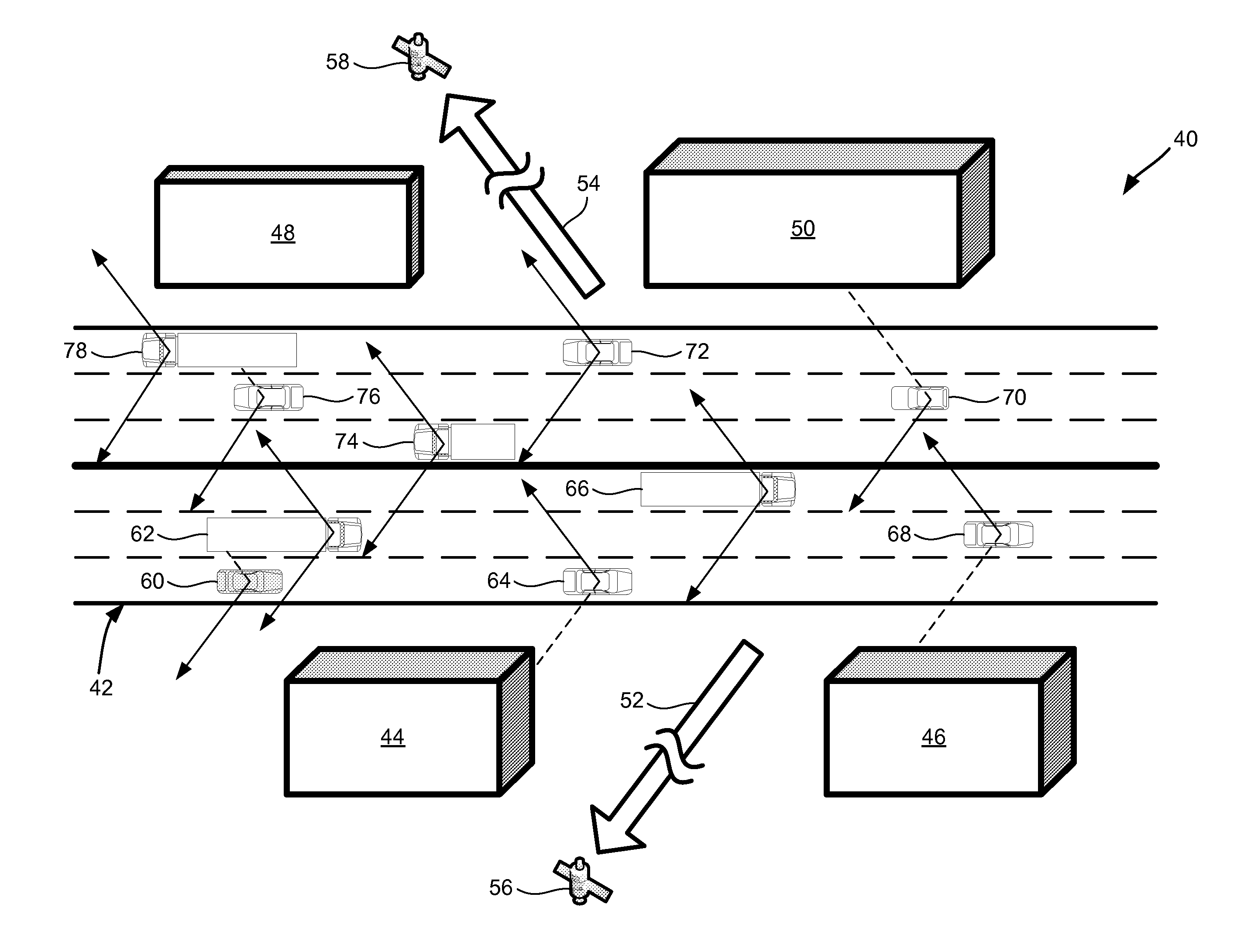
[0013]The following discussion of the embodiments of the invention directed to a method for constructing a sky visibility map is merely exemplary in nature, and is in no way intended to limit the invention or its applications or uses.

[0014]Global Navigation Satellite Systems (GNSS) is the generic name given to satellite-based navigation systems. The Global Positioning System (GPS) in the United States, and GLONASS in Russia are examples of fully operational Global Navigation Satellite Systems. Systems in Europe (Galileo) and China (Compass) are also planned for full GNSS capability. Using GNSS, a receiver device can determine its location (latitude and longitude) and elevation, as long as it can receive a signal from four or more GNSS satellites simultaneously. This is the case in standalone GNSS operation as the receiver has four unknowns to estimate, three position unknowns and the timing error. GNSS aiding techniques may reduce this requirement to three or even fewer satellites, ...


PUM


Abstract

A method and system for creating a sky visibility map, using data from a vehicle and its neighbors. A host vehicle with satellite-based navigation capability measures the quality of signals it receives from available satellites, where azimuth and elevation angles of the satellites are known from an ephemeris or almanac. The host vehicle also receives satellite signal data from surrounding vehicles via vehicle-to-vehicle communication. Using data from all of the vehicles, a sky visibility map is constructed, indicating where obstructions to satellite visibility exist for different locations. The sky visibility map is used to anticipate satellite signal quality. A driving environment classification can be used to configure other vehicle systems. The sky visibility map can also be constructed without using data from surrounding vehicles; the host vehicle can store its satellite signal data long-term and use it to estimate satellite visibility when returning to a location previously visited.

Description

BACKGROUND OF THE INVENTION[0001]1. Field of the Invention[0002]This invention relates generally to in-vehicle satellite navigation systems and, more particularly, to a method for estimating availability of signals from navigation satellites in which a host vehicle uses its own satellite signal quality information along with signal quality information from surrounding vehicles to create a sky visibility map.[0003]2. Discussion of the Related Art[0004]Many modern vehicles include navigation systems which use satellite-transmitted data to determine their latitude, longitude, and elevation—or similar location data in a different format, such as north and east offset with respect to a given origin. The Global Positioning System (GPS) in the United States is one example of these types of satellite navigation systems, collectively known as Global Navigation Satellite Systems (GNSS). Vehicles use the location data for embedded navigation purposes, and for other applications.[0005]In order ...

Claims


Application Information

Patent Timeline
IPC IPC(8): G01C21/26
CPCG01C21/32G01S19/05G01S19/258G01S19/25G01S19/39G01S5/0072H04W64/00G01S5/012
Inventor BASNAYAKE, CHAMINDA
Owner GM GLOBAL TECH OPERATIONS LLC
Why Eureka
Try Eureka