
New method for RAIM (receiver autonomous integrity monitoring) based on satellite selecting algorithm in multimode satellite navigation system

A navigation system and multi-mode satellite technology, applied in the field of global satellite navigation, can solve the problem of satellite increase

Inactive Publication Date: 2014-02-19
PEKING UNIV
View PDF5 Cites 50 Cited by
  • Summary
  • Abstract
  • Description
  • Claims
  • Application Information

AI Technical Summary

Problems solved by technology

[0021] With the rapid development of satellite navigation systems today, the use of multi-constellation integrated navigation has become an inevitable trend. However, due to the large number of visible satellites on the receiver at the same time, the traditional single-satellite failure mode is no longer applicable. Ionospheric storms, multi-path Fault detection and exclusion (Fault Detection and Exclusion) of multiple faulty satellites with simple method, high fault recognition rate, and easy hardware implementation. , FDE) method has become a new development direction

Method used


Image

  • New method for RAIM (receiver autonomous integrity monitoring) based on satellite selecting algorithm in multimode satellite navigation system
  • New method for RAIM (receiver autonomous integrity monitoring) based on satellite selecting algorithm in multimode satellite navigation system
  • New method for RAIM (receiver autonomous integrity monitoring) based on satellite selecting algorithm in multimode satellite navigation system

Examples


Embodiment Construction

[0081] The present invention will be further described in detail below in conjunction with accompanying drawings and examples.

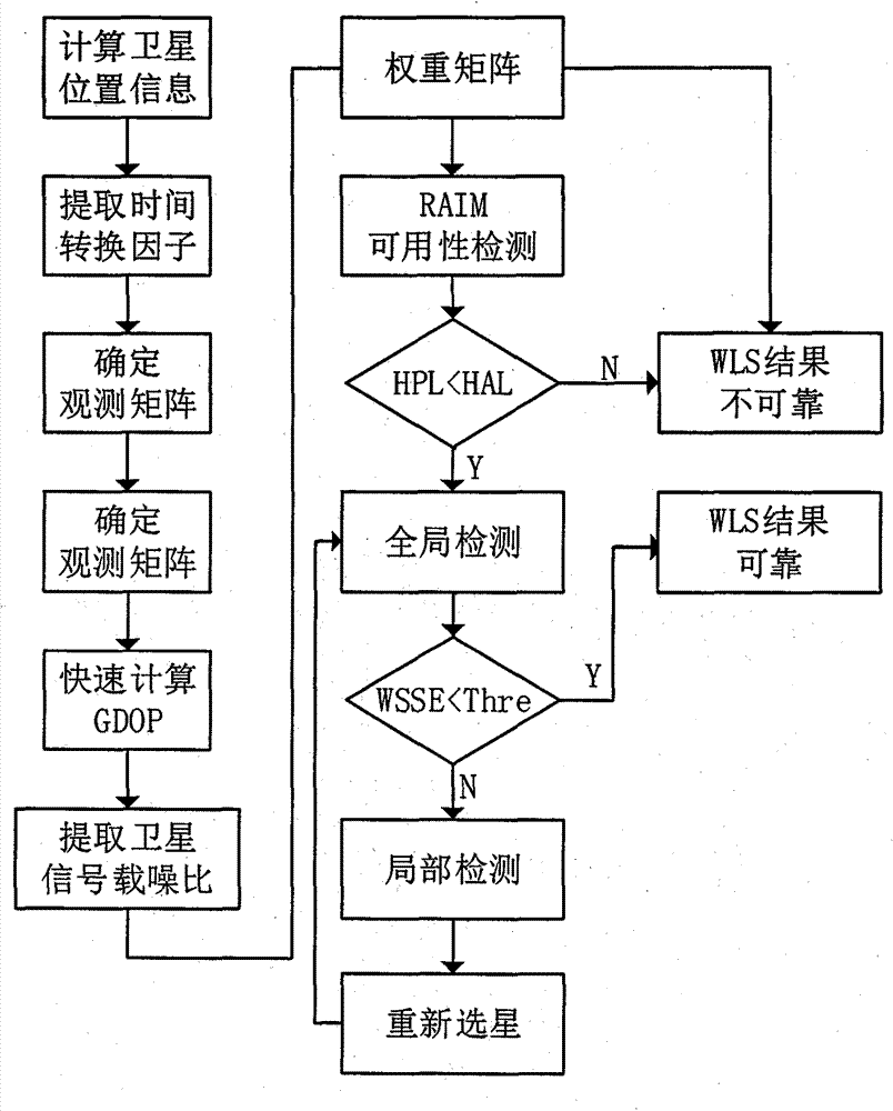
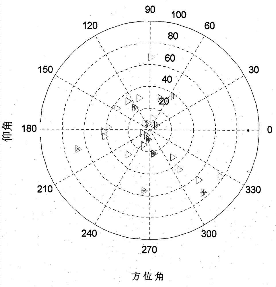
[0082] Such as figure 1 As shown, the flow chart of the RAIM method based on the satellite selection algorithm in the multi-mode satellite navigation system implemented according to steps 1 to 7 of the content of the invention. In a certain observation epoch, the satellite coordinate information is extracted according to the navigation message, and the elevation and azimuth angles of all visible satellites are calculated according to the receiver position; in the multi-mode satellite navigation system, according to the time conversion factor in the navigation message, the final Determine the observation matrix containing only one clock error item, and calculate the optimal GDOP and satellite combination according to the number of satellites and formula (11); Weight matrix, and then perform RAIM availability detection; on the premise of ensuring that...


PUM


Abstract

The invention discloses a new method for RAIM (receiver autonomous integrity monitoring) based on a satellite selecting algorithm in a multimode satellite navigation system. The method comprises the steps of first determining space position information of satellites according to a navigation message and eliminating satellites with a small elevation angle according to a shielding angle; determining an observation matrix including only one clock correction item according to clock correction conversion factors in the navigation message; selecting p satellites from N visible satellites so as to be used for positioning calculation of a receiver, acquiring a satellite combination, which enables the GDOP (geometric dilution of precision) to be minimum, through the satellite selecting algorithm to act as calculating satellites, and determining a weight matrix in WLS (weighted least squares) according to parameters such as the carrier-to-noise ratio, the loop bandwidth, pre-check integral time and the like of satellite signals; carrying out RAIM availability detection according to a false alarm rate and a missed alarm rate which are preset by the receiver, and calculating a pseudo-range residual error threshold value after positioning according to the false alarm rate and a degree of freedom in Chi-squared distribution; carrying out global detection at first, then carrying out local monitoring in a circumstance that a fault satellite exists, determining calculation satellites again through satellite selection, and finally carrying out positioning calculation through selecting satellite combinations within the threshold value. The method disclosed by the invention is simple, high in fault recognition rate, not only applicable to multi-mode and multi-fault satellite navigation systems, but also applicable to single-mode and multi-fault satellite navigation systems, thereby providing new ideas for carrying out RAIM by a modern GNSS (global navigation satellite system).

Description

technical field [0001] The invention belongs to the field of global satellite navigation, and specifically relates to a receiver autonomous integrity monitoring method in a multi-mode satellite navigation system based on a satellite selection algorithm. Background technique [0002] GNSS (Global Navigation Satellite System, GNSS) plays an extremely important role in both military and civilian fields. GNSS can be used for positioning, navigation and timing of objects at all levels of sea, land and air. Port water diversion, automobile autonomous navigation, aircraft route guidance and approach and landing, power, post and telecommunications and communication network system timing and frequency calibration, etc. [0003] The multi-mode satellite navigation system mainly includes GPS of the United States, GLONASS of Russia, Galileo of Europe and Beidou (BD / COMPASS) of China. At each positioning moment of the receiver, the number of visible satellites can usually reach 30 to 40....

Claims


Application Information

Patent Timeline
IPC IPC(8): G01S19/23
CPCG01S19/28G01S19/20
Inventor 孟凡琛汪珊朱柏承
Owner PEKING UNIV
Learn More