Time and/or accuracy dependent weights for network generation in a digital map

a network generation and digital map technology, applied in surveying and navigation, navigation instruments, instruments, etc., can solve the problems of inaccuracy or systematic errors of digital maps, high cost of digital maps to produce and update, and high cost of collecting and processing road information, so as to improve efficiency, accurate detection of branches, and merge

Active Publication Date: 2013-01-24
TOMTOM GLOBAL CONTENT
View PDF4 Cites 59 Cited by
  • Summary
  • Abstract
  • Description
  • Claims
  • Application Information

AI Technical Summary

Benefits of technology

[0030]The present invention therefore relates to the use of time-depending weight values for line segments and / or traces in combination with algorithms used to update and refine digital maps. The invention enables greater efficiency in map making and refinement processes by avoiding re-computation of a whole network through the step of strategically adjusting the weight of data based on its age. The invention is suitable for use with both incremental and non-incremental network generation algorithms. The same time models are useful also for other data mining activities. For example, the invention relates to all time-depending data, for spatial data as well as non-spatial data.
[0032]By this method, an already existing digital map, e.g. digital vector map, such as that used for road maps, bicycle maps and footpath maps and the like, can be improved using collected probe data. The improved quality of the digital vector map can be used to more accurately detect branches, merges and crossings in the digital vector map, may be used to generate both unidirectional and bidirectional networks, and represents a substantial efficiency improvement when computing large amounts of probe data over a large network area. The method is also applicable to generating digital maps, such as road maps and the like, using collected probe data.

Problems solved by technology

Digital maps are expensive to produce and update, since collecting and processing road information is very costly.
Furthermore, digital maps are likely to contain inaccuracies or systematic errors due to faulty or inaccurate input sources or flawed inference procedures.
Once a digital map has been created, it is costly to keep map information up to date, since road geometry changes over time.
In some regions of the world, digital maps are not available at all.
It may be the case that an existing roadway map or network is incomplete in its depiction of all roadways or paths within a given region.
Furthermore, due to the evolving nature of networks which may include but are not limited to roadways and paths, changes may occur over time such that an existing digital map may no longer accurately portray current conditions.
When using an incremental approach as described above, it is not possible to remove old data from the generated road network.
A problem, however, lies in that the remnant of old, possibly outdated, trace data will be factored into the incremental algorithms when analyzing the extent to which a network is to be extended or improved, and thus continue to exert influence over the analysis.
If a road segment is not in use anymore, it may have still a high weight and therefore continue to negatively influence the map refinement and extension exercises.

Method used


Image

  • Time and/or accuracy dependent weights for network generation in a digital map
  • Time and/or accuracy dependent weights for network generation in a digital map
  • Time and/or accuracy dependent weights for network generation in a digital map

Examples


Embodiment Construction

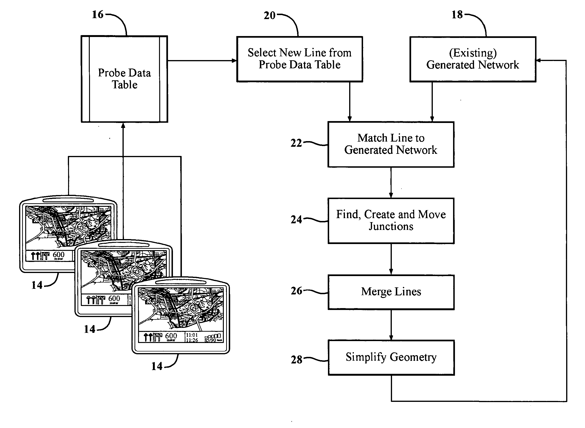
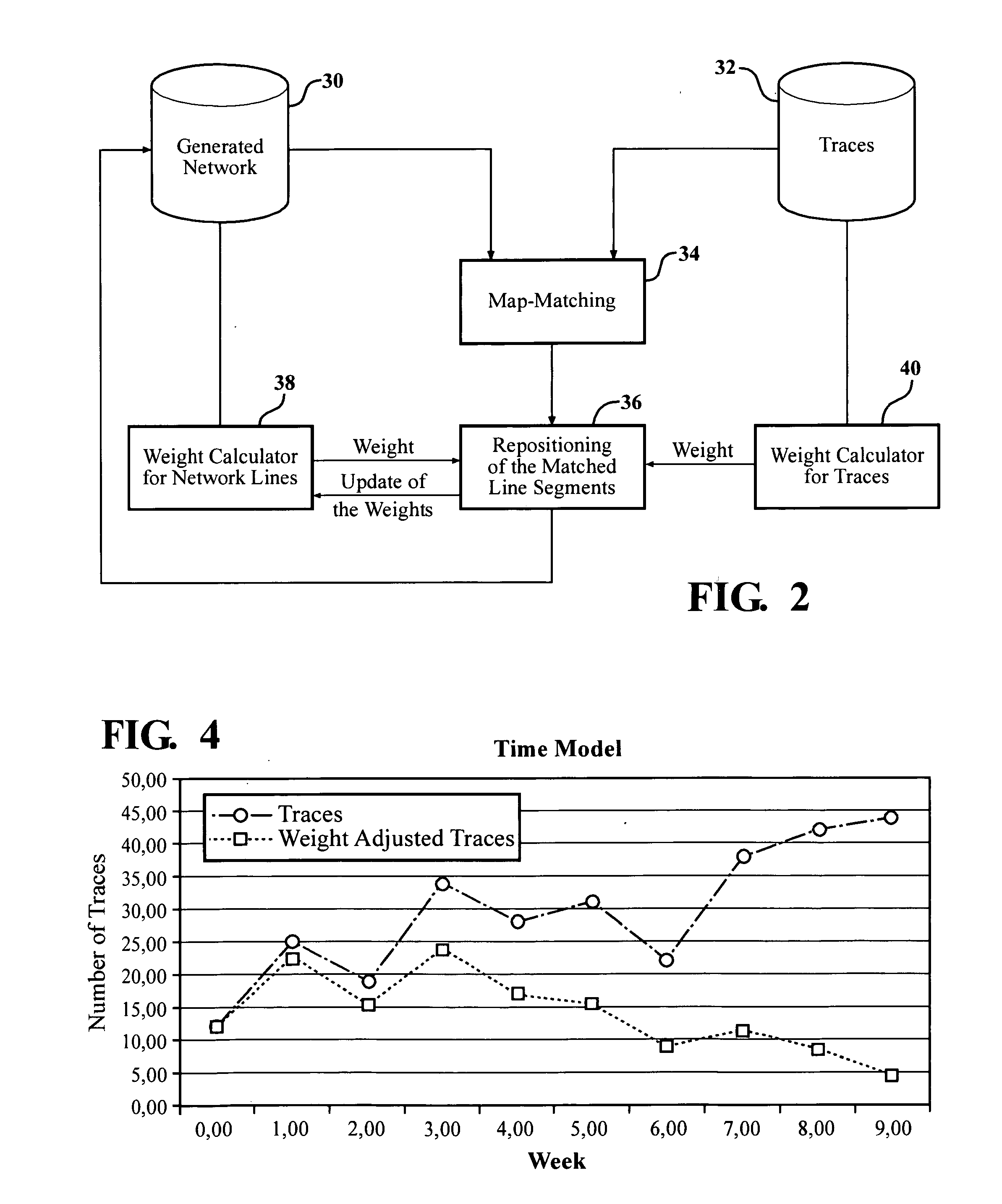
[0043]Nowadays vehicle probe data are used to hold road networks up-to-date. With different approaches it is possible to generate a new network from probe data. One class of algorithms are incremental algorithms. They have several advantages. The incremental approach allows extending and improving a network without to process the whole network again. Such an algorithm is described in the Viae Novae algorithm.

[0044]New data which are available can be easy used to refine and extend the already existing road network. However it is not possible to remove old data from the generated road network. The usage and importance of a road element is described with reference to its weight value. If a road segment is not in use anymore it may have still a high weight. In order to avoid a re-computing of the whole network one can reduce the weight of old data.

[0045]Three different, alternative, time management approaches are introduced below. All three approaches are suitable for the Viae Novae alg...


PUM


Abstract

A method for improving and extending an existing digital road network and generating new networks from statistically relevant amounts of probe data recorded by GPS-enabled navigation devices. New probe data is matched to the existing digital map, then the data merged into the existing network using a time-dependent weight and / or accuracy-dependent weight. A recalculation date is established, and the weight value of a line segment and / or trace is adjusted as a function of the time span relative to the recalculation. The function may include setting a maximal time period divided into bins each having a respective weight reduction factor, or applying decay function. Through this technique, digital maps can be updated and extended without undue influence exerted by old trace data.

Description

CROSS-REFERENCE TO RELATED APPLICATIONS[0001]This application claims priority to U.S. Provisional Patent Application No. 61 / 289,429 filed 23 Dec. 2009.BACKGROUND OF THE INVENTION[0002]1. Field of the Invention[0003]This invention relates generally to a method for generating, updating and extending digital maps, such as digital vector maps, using probe data, and more generally toward a method for improving data mining activities using advanced time models.[0004]2. Related Art[0005]Navigation systems, electronic maps (also known as digital maps), and geographical positioning devices are increasingly used by travelers to assist with various navigation functions, such as to determine the overall position and orientation of the traveler and / or vehicle, find destinations and addresses, calculate optimal routes, and provide real-time driving guidance. Typically, the navigation system includes a small display screen or graphic user interface that portrays a network of streets as a series of...

Claims


Application Information

Patent Timeline
Patent Type & Authority Applications(United States)
IPC IPC(8): G09G5/00
CPCG01C21/32G01C21/3844G01C21/3815G01C21/3841
Inventor MORLOCK, CLAYTON RICHARDMUND, HEIKO
Owner TOMTOM GLOBAL CONTENT
Why Eureka
Try Eureka