Vehicle navigation on the basis of satellite positioning data and vehicle sensor data

Active Publication Date: 2013-02-07
HARMAN BECKER AUTOMOTIVE SYST
View PDF9 Cites 18 Cited by
  • Summary
  • Abstract
  • Description
  • Claims
  • Application Information

AI Technical Summary

Benefits of technology

The patent describes a method to improve accuracy in positioning a vehicle by combining satellite positioning data with data from vehicle sensors like an odometer and a sensor for measuring steering wheel angle. This can be done using a simple algorithm called the Kalman filter. This method allows for better accuracy and efficiency in vehicle positioning, even without needing to fully implement all the filters used in other methods. The technique also utilizes information from existing sensors, making it easier to integrate into existing systems.

Problems solved by technology

However, implementation of vehicle position estimation using both satellite positioning data and measurements of an inertial navigation system may require use of a rather complex Kalman filter to combine the satellite positioning data and the measurements of the inertial navigation system.

Method used


Image

  • Vehicle navigation on the basis of satellite positioning data and vehicle sensor data
  • Vehicle navigation on the basis of satellite positioning data and vehicle sensor data
  • Vehicle navigation on the basis of satellite positioning data and vehicle sensor data

Examples


Embodiment Construction

[0023]In the following, embodiments of the invention will be described with reference to the drawings. It should be noted that features of different embodiments as described herein may be combined with each other as appropriate.

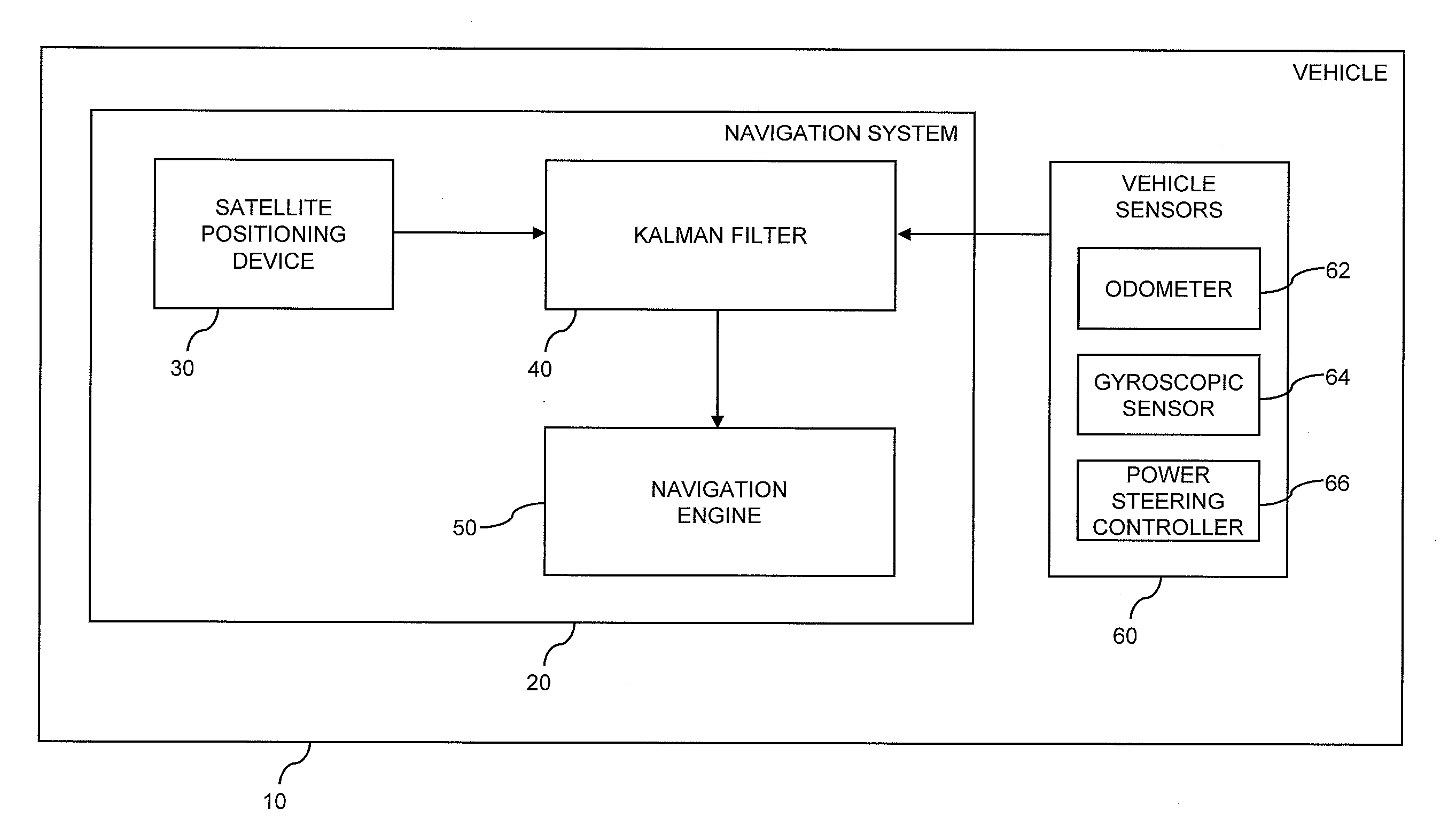
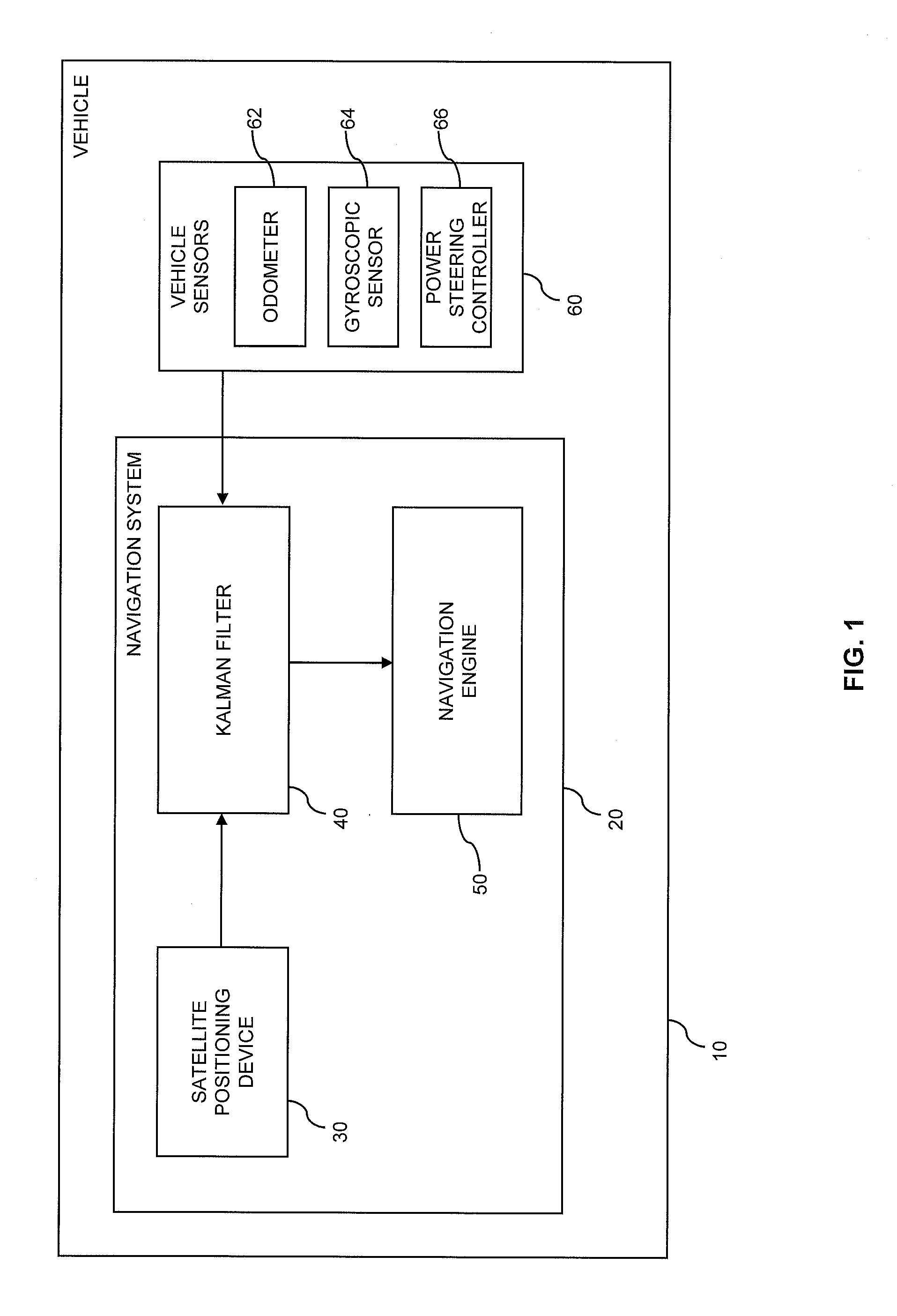
[0024]FIG. 1 schematically illustrates a vehicle 10 with a navigation system 20 according to an embodiment of the invention. As illustrated, the navigation system 20 includes a satellite positioning device 30 (e.g., a GPS receiver) a Kalman filter 40, and a navigation engine 50. The vehicle 10 further includes a plurality of vehicle sensors 60, in the illustrated example an odometer 62, a gyroscopic sensor 64, and a steering angle sensor of a power steering controller 66.

[0025]The satellite positioning device 30 is configured to obtain satellite positioning data. For example, the satellite positioning device 30 may evaluate satellite positioning signals so as to measure coordinates of the vehicle, a velocity of the vehicle, and / or a heading angle of the vehic...


PUM


Abstract

A vehicle navigation system includes a Kalman filter having a first filter receiving satellite positioning data and a second filter receiving vehicle sensor data. The first filter generates a first state vector estimate and a corresponding first state error covariance matrix. The second filter generates a second state vector estimate and a corresponding second state error covariance matrix. A third filter receives the first and second state vector estimates and the first and second state error covariance matrices, and generates a combined state vector estimate and a corresponding combined state error covariance matrix. A prediction processor generates a predicted state vector estimate and a predicted state error covariance matrix from the combined state vector estimate and the combined state error covariance matrix. The predicted state vector estimate and the predicted state error covariance matrix are provided to the first filter, the second filter, and the third filter.

Description

1. CLAIM OF PRIORITY[0001]This patent application claims priority from EP Application No. 11 176 400.7 filed Aug. 3, 2011, which is hereby incorporated by reference.2. FIELD OF TECHNOLOGY[0002]The present application relates to a method for vehicle navigation and to a corresponding navigation system.3. RELATED ART[0003]In vehicle navigation, it is known to determine the position of a vehicle from satellite positioning data. For example, such satellite positioning data may be derived from satellite positioning signals of the global positioning system (GPS) or other satellite based positioning system. In addition, it is also known to use an inertial navigation system for determining the vehicle position. For example, use of an inertial navigation system may be useful if satellite positioning signals cannot be received, such as in tunnels or other buildings.[0004]Moreover, there is also the possibility of combining satellite positioning data with measurements of an inertial navigation ...

Claims


Application Information

Patent Timeline
IPC IPC(8): G01C21/00
CPCG01S19/49G01S19/393G01C21/28G01C23/00
Inventor NATROSHVILI, KOBABUERKLE, CORNELIUS
Owner HARMAN BECKER AUTOMOTIVE SYST
Why Eureka
Try Eureka