Differential altitude measurment

a differential altitude and measurement technology, applied in the field of digital communication, can solve the problems of poor signal penetration through walls and floors, indoor positioning is very problematic, and the pseudolite navigation indoors suffers from multipaths

Inactive Publication Date: 2013-05-30
KATZ DANIEL A
View PDF1 Cites 22 Cited by
  • Summary
  • Abstract
  • Description
  • Claims
  • Application Information

AI Technical Summary

Problems solved by technology

Indoors positioning is very problematic for GNSSs, due to attenuation and multi path which the satellites signals are subject to, mainly related to the relatively high frequency of the signals broadcast by the satellites, typically in L-band.
Yet, even pseudolite navigation indoors suffers from multipath, and from poor signal penetration through walls and floors, i.e. requires heavy infrastructure.
As well known in the art, a poor geometry (i.e. low volume formed by the positions of the satellites and user) causes poor (high) DOP (dilution of position).
This poor nature of cellular/WLAN infrastructure particularly downgrades the height (or elevation or altitude) accuracy, in a way that such methods could hardly distinguis

Method used


Image

  • Differential altitude measurment
  • Differential altitude measurment
  • Differential altitude measurment

Examples


Embodiment Construction

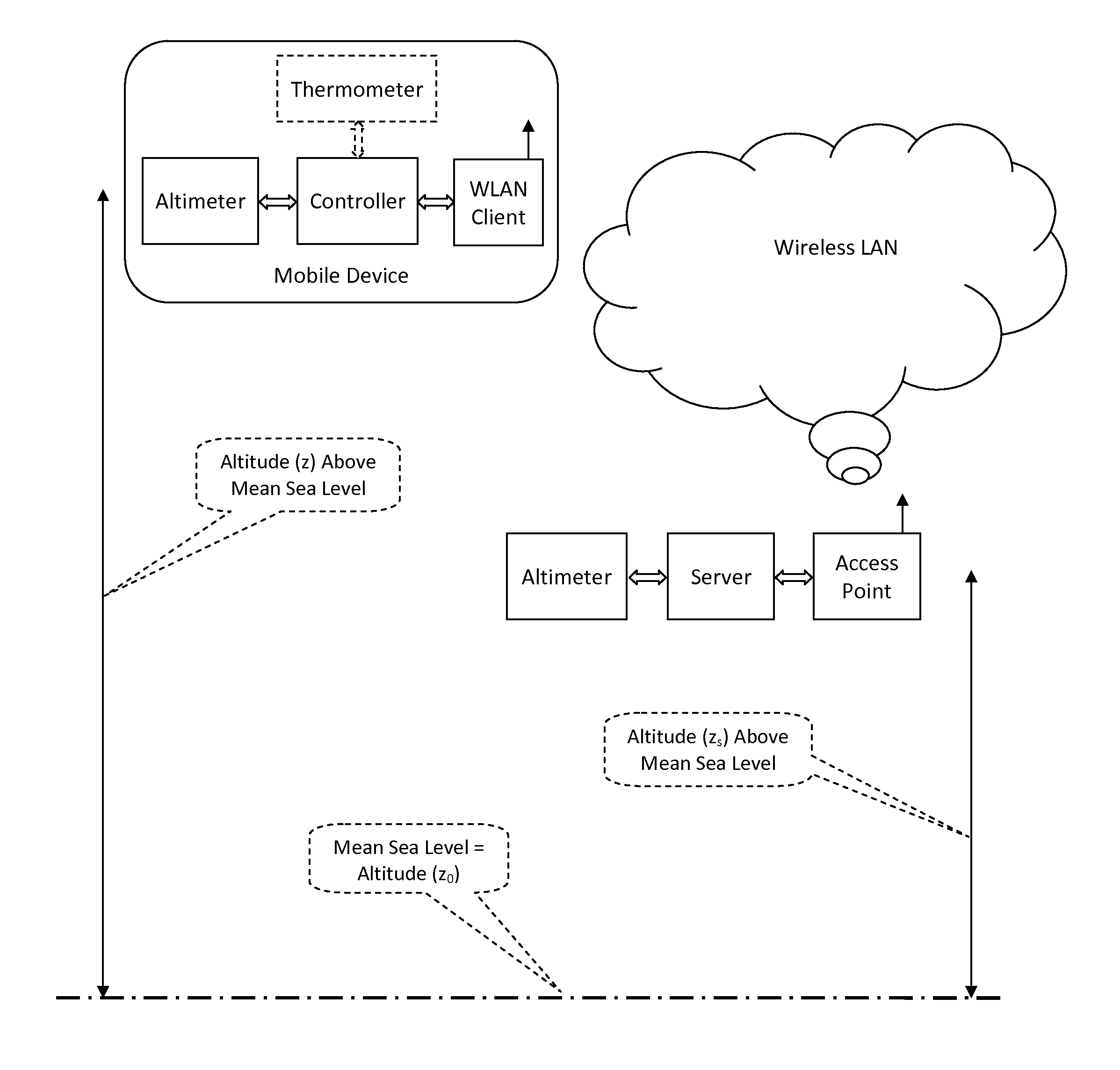
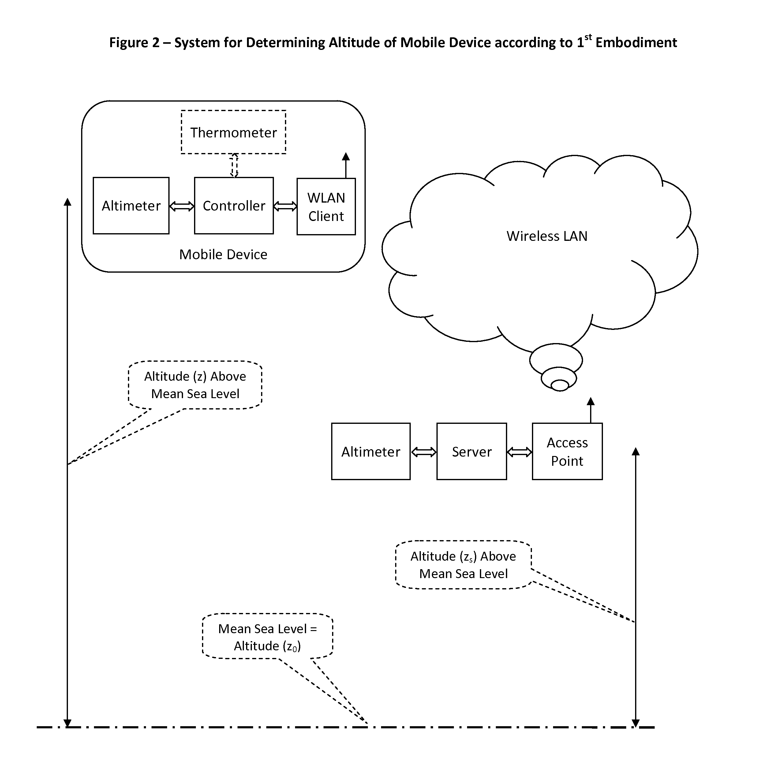
[0072]The invention is directed to a method for determining the altitude (z) of a point with known latitude (x) and known longitude (y) in a predefined geographical coordinate system, comprising the steps of:[0073]a) defining a measurable parameter associated with the altitude;[0074]b) measuring said parameter at point (x, y, z);[0075]c) defining a reference altitude (z0);[0076]d) determining at a remote location said parameter associated with the position (x, y, z0);[0077]e) communicating said parameter associated with the position (x, y, z0) to point (x, y, z);[0078]f) determining the altitude (z) at point (x, y, z).

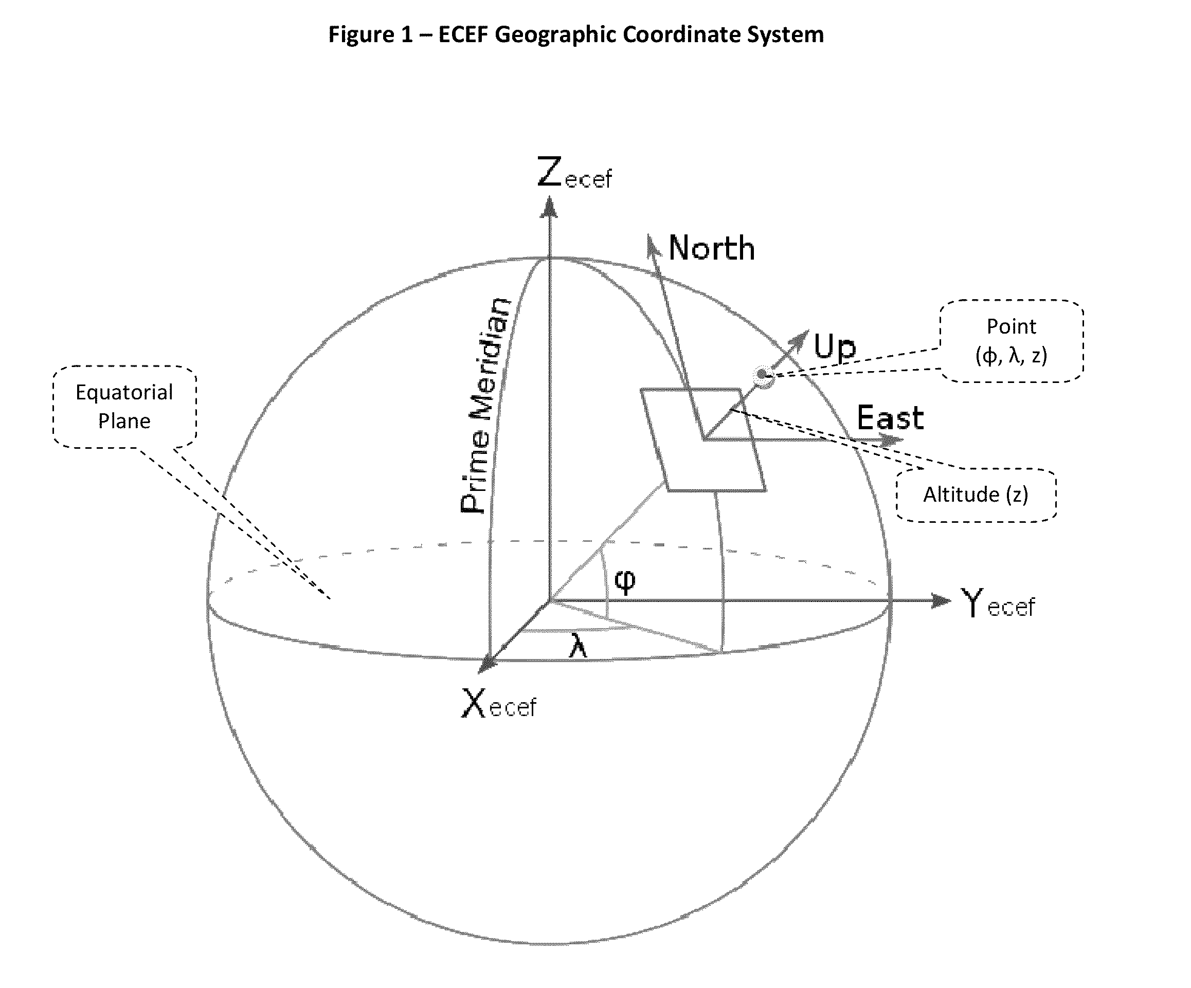
[0079]Preferably, said predefined geographical coordinate system is an ECEF (Earth Centered Earth Fixed) Cartesian three dimensional coordinate system, based on the WGS84 geodetic model, as employed by the GPS.

[0080]FIG. 1 illustrates a coordinate system known in the art as ECEF (Earth Centered Earth Fixed). The X axis and Y axis are shown on the equatorial plane and t...


PUM


Abstract

Altitude measuring devices such as barometers typically provide good differential reading yet poor absolute reading, mainly depending on dynamic weather conditions. Placed at the same altitude but on different days, a barometer based altimeter might show different altitude reading. Thus, such altimeters, when used for navigation by pilots and mountaineers, for example, require manual and timely calibration. The present invention discloses a method for automatic calibration of altitude measurement devices, such as barometers, in order to achieve good absolute readings yet avoid the present manual calibration. This method is particularly useful for indoors navigation.

Description

BACKGROUND OF THE INVENTION[0001]The present invention relates to the art of digital communications, particularly to radio navigation.[0002]Global Navigation Satellite Systems (GNSS), such as the US GPS and the Russian GLONASS, are very effective and popular means of positioning and navigation. Basically, a GNSS receiver is configured to determine its (x, y, z) coordinates, according to a pre defined geographical coordinate system known in the art as ECEF (Earth Center Earth Fixed).[0003]The ECEF coordinate system rotates with the Earth and has its origin at the earth centre. The X axis passes through the equator (latitude 0°) at the prime meridian (longitude 0°, on Greenwich). The Z axis passes through the North Pole, substantially aligned with the instantaneous Earth rotational axis.[0004]FIG. 1 depicts the ECEF Geographic Coordinate System.[0005]However, GNSSs are usually designed to operate in open spaces, where there is substantially a line of sight between the receiver and the...

Claims


Application Information

Patent Timeline
IPC IPC(8): G01L7/00G01P15/18G01S19/31
CPCG01C5/06
Inventor KATZ, DANIEL A.
Owner KATZ DANIEL A
Why Eureka
Try Eureka