Navigating using an indoor map representation

a technology of indoor map and representation, applied in the direction of location information based service, filling the planer surface with attributes, wireless commuication service, etc., can solve the problems of inconvenient use of road graph, and inefficient use of navigation map data for the purposes of the above described problem

Active Publication Date: 2014-04-24
GOOGLE LLC
View PDF9 Cites 19 Cited by
  • Summary
  • Abstract
  • Description
  • Claims
  • Application Information

AI Technical Summary

Problems solved by technology

The road graph as described above is not suitable for a walking or indoor environment because it may be overly complicated for a mobile device to process, and because users generally travel within open space, rather than along set pathways.
For this reason, such representations may not be optimal for areas with open space or other navigable space that cannot be efficiently represented by line segments.
Thus, navigation map data provided by a road graph may be overly complicated and inefficient for the purposes of providing a representation of an indoor navigation environment.

Method used


Image

  • Navigating using an indoor map representation
  • Navigating using an indoor map representation
  • Navigating using an indoor map representation

Examples


Embodiment Construction

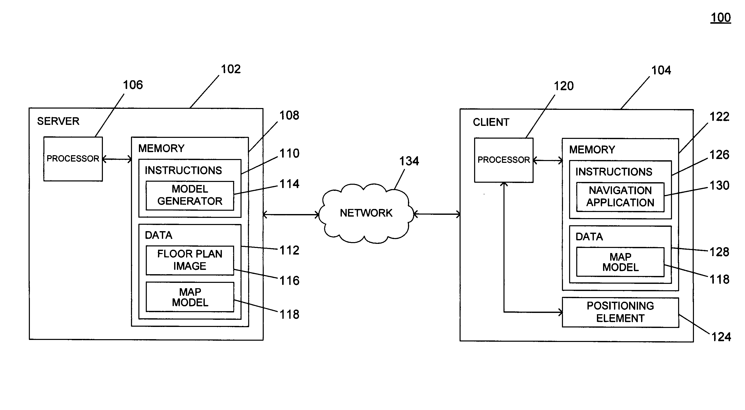
[0012]A method and system for navigating using an indoor map representation are described here. Aspects of this disclosure provide an efficient representation of an indoor environment that can be used to perform navigation and route-finding operations. The indoor map representation may be provided to a client device as a series of vertices that describe a series of polygons and relationship data that identifies the adjacency relationships among the polygons. These polygons may identify areas of navigable space within the indoor environment. This indoor map representation may be used to perform route-finding operations from a source point to a destination point by identifying a path across adjacent polygons.

[0013]FIG. 1 is a system diagram depicting an example of an indoor navigation system 100 in accordance with aspects of the disclosure. As shown in FIG. 1, an example indoor navigation system 100 includes a server 102 and a client 104 in communication via a network 134. The server ...


PUM


Abstract

A method and system for providing an indoor map representation are provided herein. Aspects of this disclosure provide a representation of an indoor map environment whereby navigable areas are represented by a series of convex polygons in adjacency relationships with one another. Image analysis may be performed on a floor plan image to identify navigable areas and to determine the boundaries of the polygons, such as by assigning one or more colors to navigable space and one or more colors to non-navigable space. Route-finding operations may be performed using the adjacency relationships to find a path from a source area to a destination area.

Description

BACKGROUND[0001]The proliferation of smart phones and other mobile devices has placed more processing power in the hands of consumers than ever before. These mobile devices are capable of executing a variety of applications, including applications that assist with navigation and route-finding. Traditional global positioning system (GPS) navigation devices are used to assist automobile owners with driving operations from a source to a destination, and navigation software is generally developed with the use-case of driving directions in mind. These devices may provide map data in the form of a road graph, with valid driving paths represented by line segments which intersect at various points, and which have a directionality element indicating valid directions of travel along the line segments. Such a design is efficient for use in situations where the user is travelling via a vehicle, as the vehicle is limited to particular pathways of travel.[0002]However, as mobile devices increasin...

Claims


Application Information

Patent Timeline
Patent Type & Authority Applications(United States)
IPC IPC(8): H04W4/04H04W4/33
CPCH04W4/043G01C21/206H04W4/33G06T11/40
Inventor LI, GUANFENGZHANG, FAENWANG, FENG
Owner GOOGLE LLC
Why Eureka
Try Eureka