Single image pose estimation of image capture devices

Active Publication Date: 2014-07-31
HILTI AG
View PDF5 Cites 61 Cited by
  • Summary
  • Abstract
  • Description
  • Claims
  • Application Information

AI Technical Summary

Benefits of technology

[0003]The following presents a simplified summary of some embodiments of the invention in order to provide a basic understanding of the invention. This summary is not an extensive overview of the invention. It is not intended to identify key/critical elements of the invention or to delineate the scope of the invention. Its sole purpose is to present some embodiments of the invention in a simplified form as a prelude to the more detailed description that is presented below.
[0004]As such, methods for image based localization using an electronic computing device are presented, the methods including: capturing a local image with an image capture device; associating metadata with the local image; causing the electronic computing device to receive the local image; causing the electronic computing device to match the local image with a database image, where the database image is three-dimensional (3D); and calculating a pose of the image capture device based on a pose of the database image and metadata associated with the local image. In some embodiments, the metadata includes at least pitch and roll data corresponding with the image capture device at a time of image capture. In some embodiments, the calculating the pose includes: extracting the pitch and roll data from the metadata; extracting yaw data from the metadata; matching features between the local image and the database image; and estimating a homography matrix to solve for translation of the image capture device with respect to the database image. In some embodiments, the matching features includes: extracting high resolution scale invariant feature transform (SIFT) features from the local image and the database image; performing a nearest neighbor search to establish any correspondence between the extracted SIFT features of the local image and the database image; excluding any corresponding database image SIFT features that lack depth data; and excluding ground plane SIFT features of the database image. In some embodiments, methods further include: if the yaw data from metadata of the local image captured is noisy, extracting a first number of vanishing points corresponding with the local image; extracting a second number of vanishing points corresponding with the database image: finding a best alignment pair between the vanishing points; calculating a corrected yaw of the image capture device; and calculating a normal direction of a vertical plane associated with each vanishing point in the local image that was matched to the vanishing point in the database image. In some embodiments, estimating the homography matrix includes: recovering a 3D translation vector, where the 3D translation vector includes direction and magnitude, between the loc

Problems solved by technology

Even though most of today's cell phones are equipped with sensors such as GPS, accelerometers, and gyros, pose estimated via these is often inaccurate.
This is particularly true in urban environments where tall buildings may block satellite view for GPS and distortions in Earth's magnetic field from power lines adversely affect compass readings.
In addition, indoor environments whether urban or rural present similar issues wit

Method used


Image

  • Single image pose estimation of image capture devices
  • Single image pose estimation of image capture devices
  • Single image pose estimation of image capture devices

Examples


Embodiment Construction

Notation

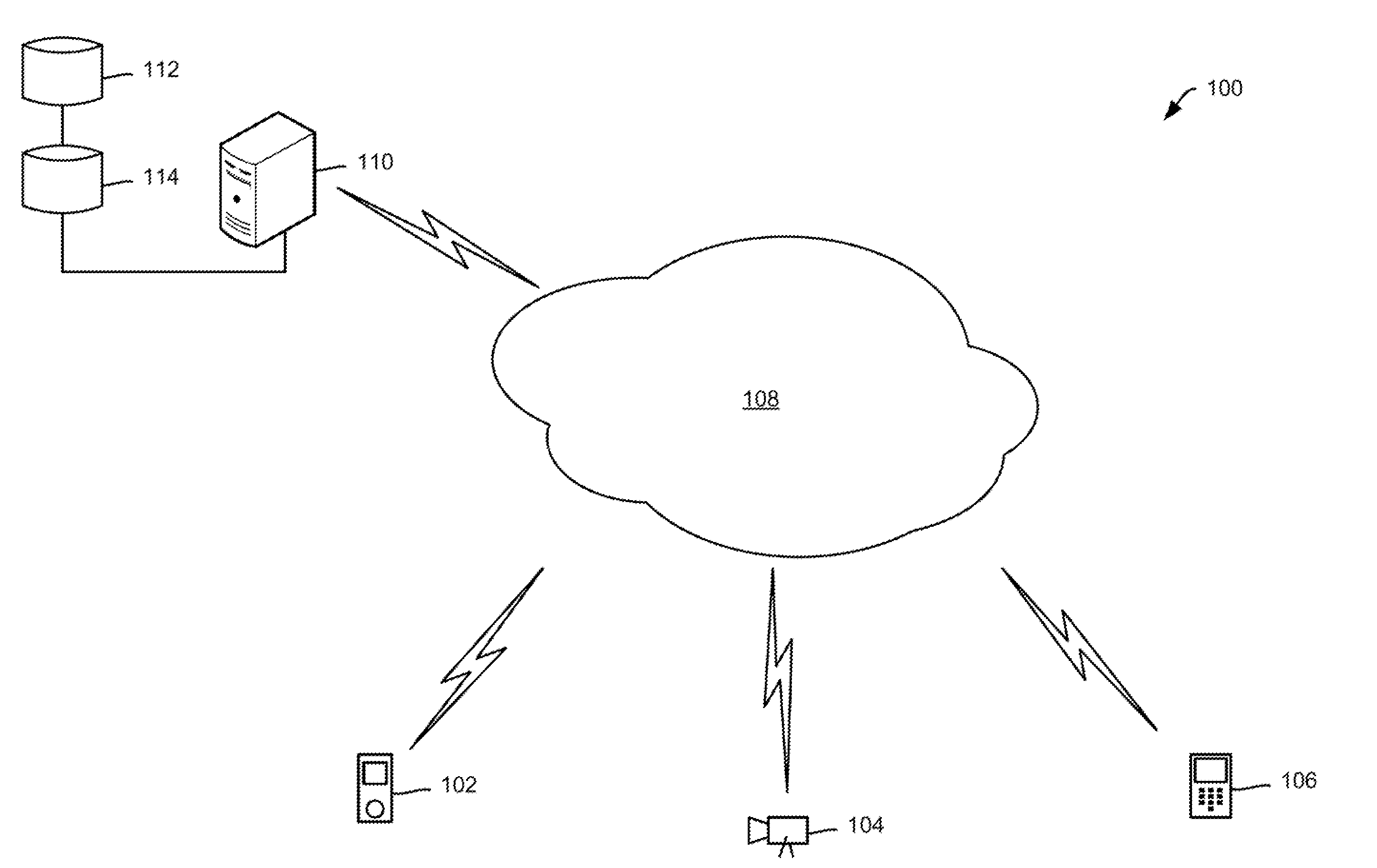
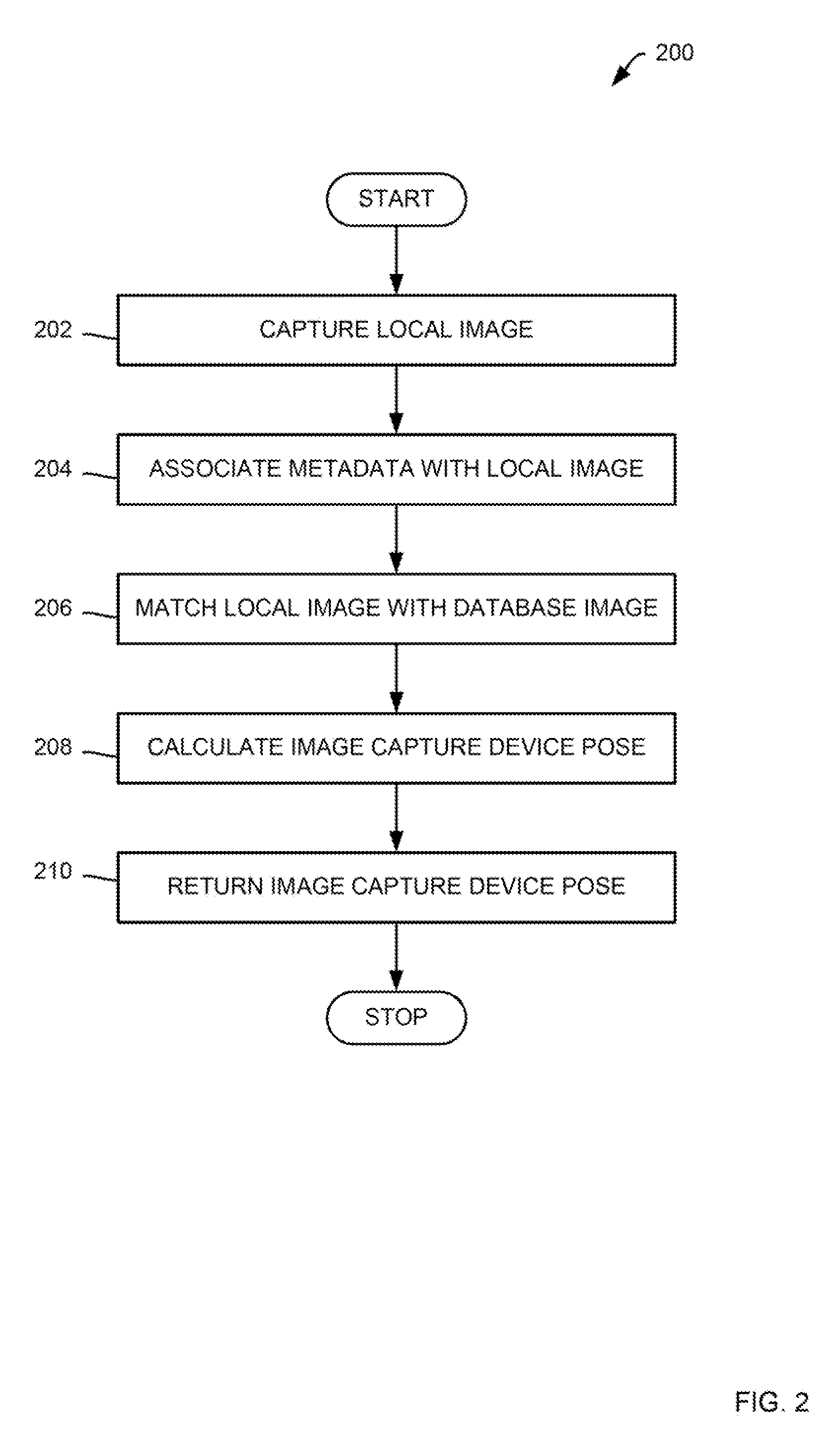
[0012]The following multiple coordinate systems and types of variables are utilized throughout this disclosure. As such, a local image taken from a image capture device is referred to as Q and its matched database image retrieved from a database as D. Furthermore, a full three-dimensional (3D) vector has a known scale and 3 independent parameters, while a 3D ray is always normalized and has an unknown scale, i.e. 2 independent parameters. In an effort to maintain clarity, the following notation is used:

[0013]Capital letters denote matrices, sets, and objects while lowercase letters denote vectors and scalars:

[0014]Hat on top to denote a normalized vector or a 3D ray, e.g. {circumflex over (t)} as the direction of translation.

[0015]Vector symbol to denote a full 3D vector with scale, e.g. to denote 3D translation.

[0016]Nothing on top of lower-case letters to denote a scalar.

[0017]For capital letters, scripts denote a set, bolds denote a matrix, normal capitals denote an obje...


PUM


Abstract

Methods for image based localization using an electronic computing device are presented, the methods including: capturing a local image with an image capture device; associating metadata with the local image; causing the electronic computing device to receive the local image; causing the electronic computing device to match the local image with a database image, where the database image is three-dimensional (3D); and calculating a pose of the image capture device based on a pose of the database image and metadata associated with the local image. In some embodiments, the metadata includes at least pitch and roll data corresponding with the image capture device at a time of image capture.

Description

BACKGROUND[0001]Pose estimation of mobile devices is useful for a wide variety of applications, including augmented reality and geo-tagging. Even though most of today's cell phones are equipped with sensors such as GPS, accelerometers, and gyros, pose estimated via these is often inaccurate. This is particularly true in urban environments where tall buildings may block satellite view for GPS and distortions in Earth's magnetic field from power lines adversely affect compass readings. In addition, indoor environments whether urban or rural present similar issues with respect to GPS reception and distortions due to power lines and other structural components of a building.[0002]In order to determine pose, most modern smart-phones are equipped with full sensor packages, including an accelerometer, gyros, GPS, and a compass. For example, an application such as YELP MONOCLE™ utilizes a phone's GPS and compass to overlay nearby entities such as shops and restaurants on the viewfinder. Unf...

Claims


Application Information

Patent Timeline
IPC IPC(8): G06F3/14
CPCG06F3/1415G06T2207/30244G06T7/80G06V10/462
Inventor HALLQUIST, AARONZAKHOR, AVIDEH
Owner HILTI AG
Why Eureka
Try Eureka