
System and Method for Map Matching

a map matching and system technology, applied in the field of system and method for map matching, can solve the problems of complicated map matching problem, urban area severe degradation of gps accuracy, complex and ambiguous road geometry,

Active Publication Date: 2014-12-04
HARMAN INT IND INC
View PDF4 Cites 30 Cited by
  • Summary
  • Abstract
  • Description
  • Claims
  • Application Information

AI Technical Summary

Benefits of technology

The patent text describes a system and method for dealing with the problem of matching lanes in a vehicle's position. The system uses various methods to estimate position corrections, map matching confidence, and self-correcting map matching. The text also mentions that the use of V2V data can make it easier to determine which lane the vehicle is in, which can improve the overall accuracy of the system.

Problems solved by technology

However, GPS accuracy can be severely degraded in urban areas especially with tall building and green areas with significant tree existence.
In addition, road geometry can be complex and ambiguous, such as road branching.
Finally, vehicle dynamics such as lane change and turning can also complicate the map matching problem.
People inherently make a lot of mistakes during driving (and cause accidents), due to the lack of sleep, various distractions, talking to others in the vehicle, fast driving, long driving, heavy traffic, rain, snow, fog, ice, or too much drinking.

Method used


Image

  • System and Method for Map Matching
  • System and Method for Map Matching
  • System and Method for Map Matching

Examples


Embodiment Construction

[0047]Here, we describe an embodiment of the invention, using an example: (referring to FIGS. 37-38)

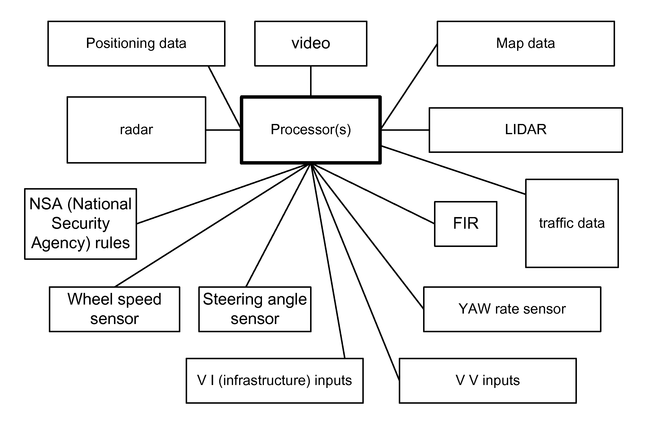
[0048]FIG. 37 is for one embodiment of the invention, related to a method or steps taken for map matching. It starts from setting the initial conditions. Then, it selects all possible travel lanes in the area. It determines distances, angles, and directions. It uses the equation of line for this step. Then, it determines the type of the matched lane. It applies the lane change event flag, followed by application of the turn or branching flag. Then, it performs the changing lane assignment, followed by changing road assignment. Then, it can repeat this process again, or if the tasks are complete, it can exit the loop and process. More details are given below in each section corresponding to each of the 7 steps.

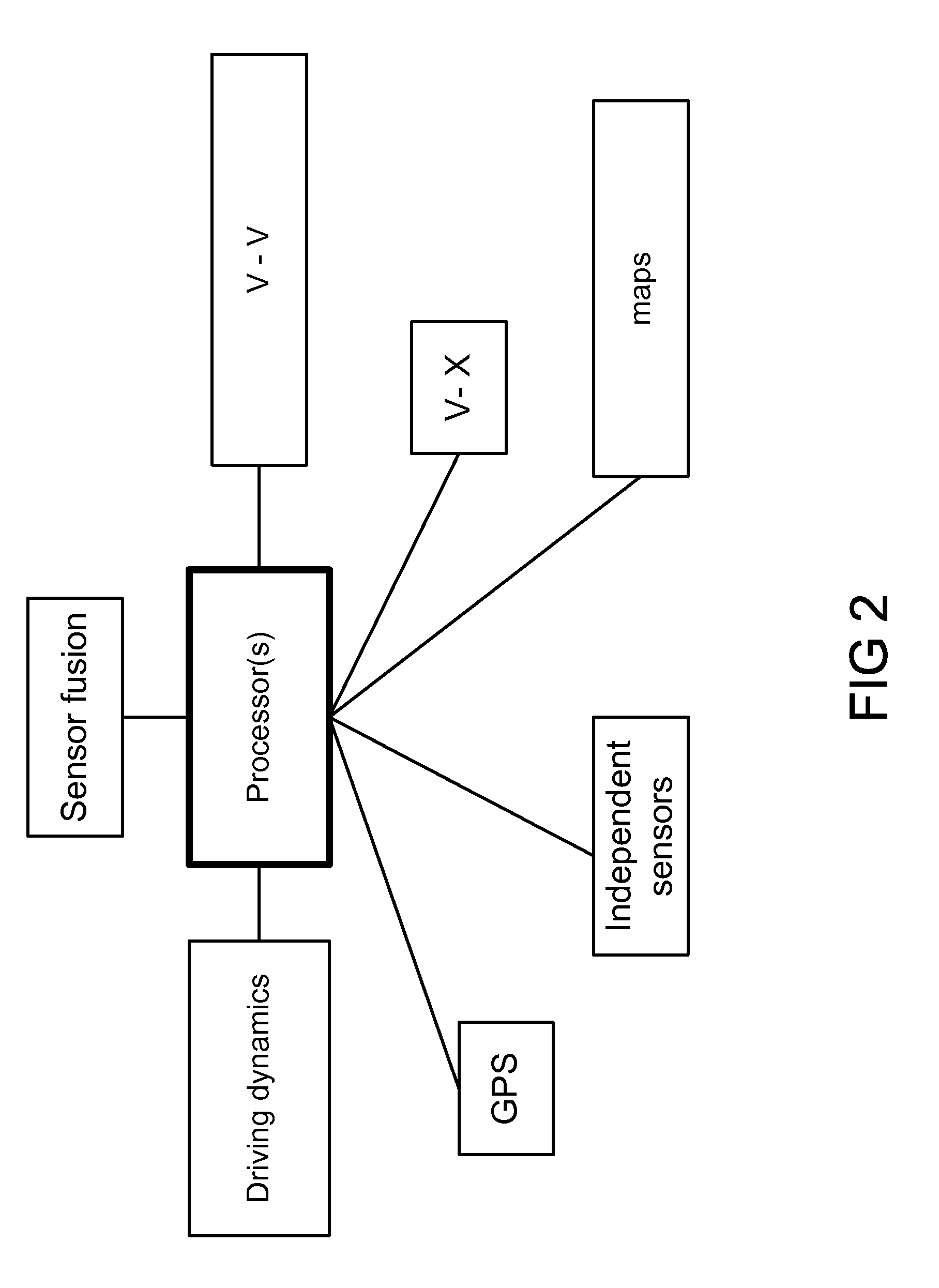
[0049]FIG. 38 is for one embodiment of the invention, related to a system for map matching. The system has a travel lane repository, using dynamic and configurable parameters. It...


PUM


Abstract

In one example, we describe a method, system, and infrastructure for dealing with lane-level matching problem, and provide different methods of estimating position corrections, position and map matched confidence, self-correcting map matching (i.e., Map Matching Algorithm (at lane-level)), and turning and lane change events. On the top of the described algorithms, the V2V data, when available, can be used to help the entire discussed algorithm steps. If the relative GPS accuracy between the host vehicle and the remote vehicles in the proximity of the host vehicle is enough to separate vehicle in lane, and there are enough vehicles to exist in all lanes of interest, then it becomes an easier job to determine which lane the host vehicle is in, and this can reflect very positively on all the above algorithm steps.

Description

RELATED APPLICATIONS[0001]This application is a CIP of two other co-pending US utility applications, namely, Ser. No. 13 / 907,864, titled “System and method for lane boundary estimation and host vehicle position and orientation”, filed 1 Jun. 2013, and Ser. No. 13 / 907,862, titled “System and method for node adaptive filtering and congestion control for safety and mobility applications toward automated vehicles system”, filed 1 Jun. 2013. The teachings of the above applications are incorporated herein, by reference. The current application claims the priority date of the above applications.BACKGROUND OF THE INVENTION[0002]Map matching algorithms are well known in the industry and used extensively for the land vehicle positioning / navigation systems. First, maps were generated, mainly using aerial images, and commercial navigation system started with GPS accuracy below 100 meter. Then, GPS accuracy became better to below 10 meter, and the map accuracy also increased (in most of road cla...

Claims


Application Information

Patent Timeline
Patent Type & Authority Applications(United States)
IPC IPC(8): G05D1/00
CPCG05D1/0055G01C21/30B60W30/12B60W2556/55B60W2556/65B60W2554/00B60W2556/50B60W2554/806
Inventor IBRAHIM, FAROOG
Owner HARMAN INT IND INC
Features
  • Generate Ideas
  • Intellectual Property
  • Life Sciences
  • Materials
  • Tech Scout
  • Unparalleled Data Quality
  • Higher Quality Content
  • 60% Fewer Hallucinations
Learn More