Supercharge Your Innovation With Domain-Expert AI Agents!

Tactical differential GPS

a technology of differential positioning and gps, applied in the field of tactical differential positioning, can solve the problems of difficulty in identifying the map location used to correct the position received by the gps receiver, and the accuracy of civilian use is restricted, so as to improve the accuracy of a radio-based navigation system, and eliminate drawbacks

Active Publication Date: 2015-02-19
SAAB AB
View PDF6 Cites 3 Cited by
  • Summary
  • Abstract
  • Description
  • Claims
  • Application Information

AI Technical Summary

Benefits of technology

The technical effects of this patent text aim to solve the limitations of existing solutions and improve the accuracy of radio based navigation systems utilizing 3D map data.

Problems solved by technology

The accuracy is restricted for civilian use where techniques such as differential GPS is developed to improve the accuracy.
Problem with the solution described in WO00 / 50917 for improved navigation accuracy is the difficulty to identify the map location that is used to correct the position received by the GPS receiver.

Method used


Image

  • Tactical differential GPS
  • Tactical differential GPS
  • Tactical differential GPS

Examples


Embodiment Construction

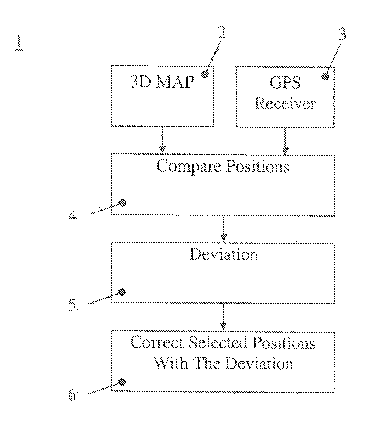
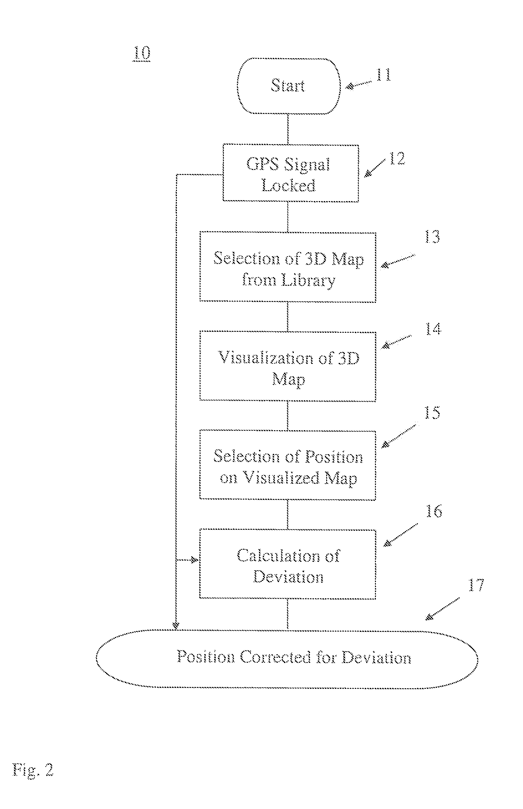
[0024]A schematic diagram of the method for improving the accuracy of a radio based navigation system is shown in FIG. 1. A Compare Positions block 4 receives input signals from a database containing information for 3D Maps 2 and a navigation signal from a GPS Receiver 3. The navigation signal could also be provided by other radio based navigation systems. A method to make 3D maps is described in the patent application WO2011 / 093752. A method and technology suitable for creating a 3D map is called Rapid 3D Mapping™. The 3D map data contains position information for an area where the position coordinates for the 3D map is a combination of localization information of position and altitude together with a visual component. The visual component for visualization of a surface could be a part of a photo of the visualized surroundings or a coloured area. One of several known formats for representing 3D surfaces are TIN, Triangulated Irregular Network, that is a vector based representation ...


PUM


Abstract

A method for improving an accuracy of a radio based navigation system by correcting the position given by the radio based navigation system with a correction vector derived from localization data stored in a map database. Position coordinates of the radio based navigation system are measured. A set of 3D map data is selected based upon the measured position coordinates of the radio based navigation system position coordinates. The actual position is determined from the selected 3D map data. The actual position data coordinates are retrieved from the 3D map data based upon the determined actual position. The correction vector is calculated from position difference between measured radio based navigation system position coordinates and retrieved actual position coordinates. The position given by the radio based navigation system is corrected with the correction vector.

Description

TECHNICAL FIELD[0001]The present invention relates to a method for improving the accuracy of a radio based navigation system by correcting the position given by the said radio based navigation system with a correction vector derived from localization data stored in a map database.BACKGROUND ART[0002]There exists several different radio based navigation systems of which the GPS system is the most well known. GPS is an abbreviation of Global Positioning System and is a global covering and from satellite transmitted radio based navigation system. The GPS system provides high accuracy and has in principle two accuracy classes where full accuracy only is available for the military GPS. The accuracy is restricted for civilian use where techniques such as differential GPS is developed to improve the accuracy. Differential GPS provides improved location accuracy compared to ordinary GPS by using radio signals from a network of fixed ground base reference stations with a known position. The ...

Claims


Application Information

Patent Timeline
Patent Type & Authority Applications(United States)
IPC IPC(8): G01S19/40G01C21/30
CPCG01C21/30G01S19/40
Inventor PERSSON, PER-OLOFMICHEL, ROLF
Owner SAAB AB
Features
  • R&D
  • Intellectual Property
  • Life Sciences
  • Materials
  • Tech Scout
  • Unparalleled Data Quality
  • Higher Quality Content
  • 60% Fewer Hallucinations
Learn More