Terrain mapping system using virtual tracking features

a technology of tracking features and terrain maps, applied in the field of terrain mapping systems, can solve the problems of inaccurate elevation and contour information on the terrain map, incomplete terrain maps may be created, and inefficient and inaccura

Active Publication Date: 2015-07-16
CATERPILLAR INC
View PDF0 Cites 9 Cited by
  • Summary
  • Abstract
  • Description
  • Claims
  • Application Information

AI Technical Summary

Problems solved by technology

Although the system of the '550 publication may map terrain, it may be inefficient and inaccurate.
This can lead to inaccurate elevation and contour information on the terrain map.
As a result, an incomplete terrain map may be created.

Method used


Image

  • Terrain mapping system using virtual tracking features
  • Terrain mapping system using virtual tracking features
  • Terrain mapping system using virtual tracking features

Examples


Embodiment Construction

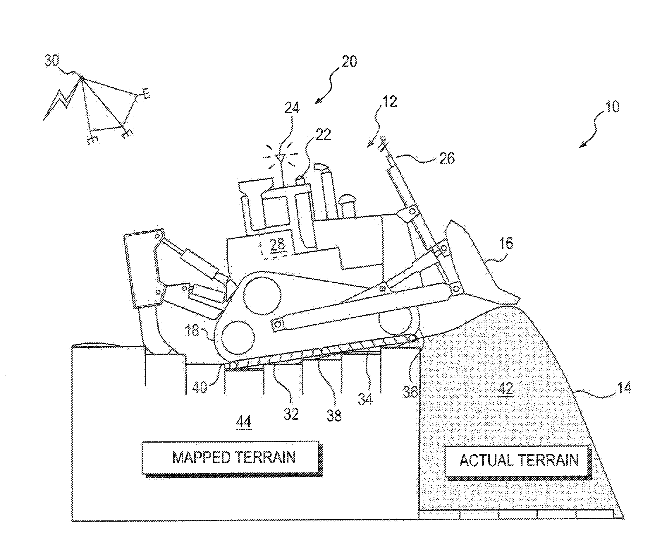
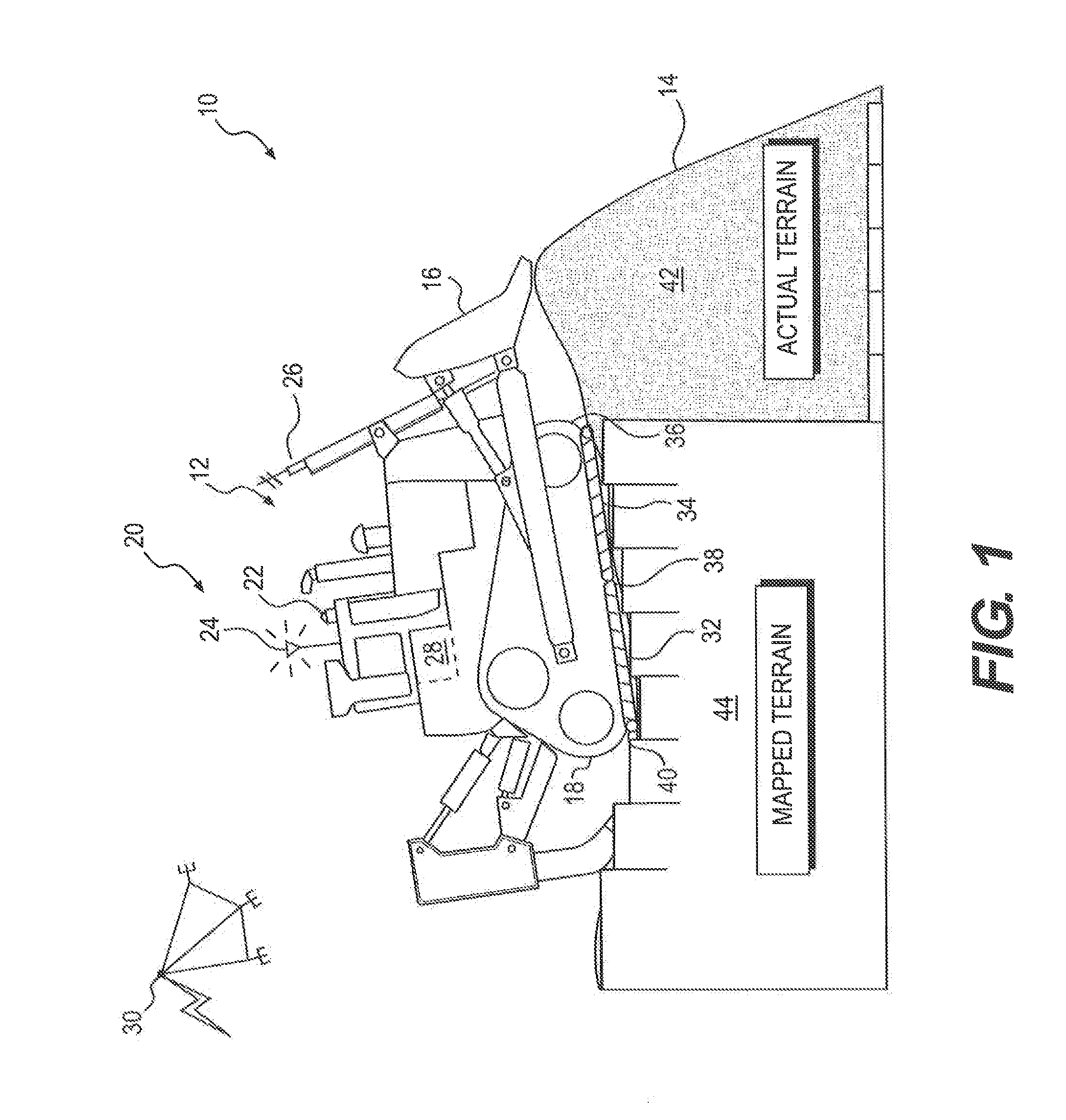
[0014]FIG. 1 illustrates a worksite 10 and an exemplary machine 12 performing a task at worksite 10. Worksite 10 may include, for example, a mine site, a landfill, a quarry, a construction site, or any other type of worksite having terrain 14 traversable by machine 12. The task being performed by machine 12 may be associated with altering the geography at worksite 10, and may include a hauling operation, a grading operation, a leveling operation, a plowing operation, a bulk material removal operation, or any other type of operation. As machine 12 operates at worksite 10, the shapes, dimensions, and general positions of terrain 14 may change.

[0015]Machine 12 may embody a mobile machine, for example a dozer, a haul truck, a motor grader, or a loader. Machine 12 may be a manned machine configured to traverse terrain 14 under the control of an operator, a self-directed machine configured to autonomously traverse terrain 14, or a hybrid machine configured to perform some functions autono...


PUM


Abstract

A terrain mapping system is disclosed for a machine having at least one traction device. The system may have a sensor associated with the machine and configured to generate a signal indicative of a position of the machine. The system may also have at least one controller in communication with the sensor. The at least one controller may be configured to receive the signal from the sensor, and divide an area between the at least one traction device and a work surface into a plurality of virtual tracking features based on the signal and known geometry of the machine. The at least one controller may also be configured to track movement of the plurality of virtual tracking features, and update an electronic terrain map of a worksite based on the movement of the plurality of virtual tracking features.

Description

TECHNICAL FIELD[0001]The present disclosure relates generally to a terrain mapping system, and more particularly, to a terrain mapping system using virtual tracking features.BACKGROUND[0002]Terrain at a worksite commonly undergoes geographic alteration by machines through, for example, digging, grading, leveling, or otherwise preparing the terrain for various uses. In some applications, it may be useful to map the terrain during this process. For instance, it may be advantageous to map terrain for use in identifying elevation and contour information at various points within a worksite. Having an accurate and complete terrain map may assist an operator in controlling the machine or, in some applications, facilitate autonomous control of the machines in navigating through the worksite.[0003]One system for mapping terrain is described in U.S. Patent Application Publication No. 2012 / 0330550 (the '550 publication) to Jensen et al. The '550 publication describes a system having a machine ...

Claims


Application Information

Patent Timeline
Patent Type & Authority Applications(United States)
IPC IPC(8): G01V9/00G01V99/00
CPCG01V99/00G01V9/00G05D2201/0202G01C21/20
Inventor CLAR, JEAN-JACQUESBECICKA, TROY KENNETHTAYLOR, MICHAEL ALLENMCGEE, ROBERT JASON
Owner CATERPILLAR INC
Why Eureka
Try Eureka