Sky Polarization and Sun Sensor System and Method

a sensor system and sun sensor technology, applied in the field of sky polarization and sun sensor system and method, can solve the problems of reducing availability, yaw measurement using a compass can be inaccurate by many degrees, and localization analysis is subject to drift and error accumulation, etc., and achieves some accuracy.

Active Publication Date: 2015-08-13
POLARIS SENSOR TECH
View PDF9 Cites 33 Cited by
  • Summary
  • Abstract
  • Description
  • Claims
  • Application Information

AI Technical Summary

Benefits of technology

[0005]A method according to the present disclosure calculates orientation and position parameters using a sky polarimeter that takes polarized images of multiple simultaneous target points in the sky. The orientation and position parameters can be useful to a navigating vehicle (especially if UPS is denied, spoofed, or unavailable), and can work in all types of vehicles (including ground, ai

Problems solved by technology

Such localization analysis, however, is subject to drift and error accumulation.
Yaw, for example, is typically calculated using a compass, which can be unreliable due to variations of the earth's magnetic field direction on the surface of the earth, meaning yaw measureme

Method used


Image

  • Sky Polarization and Sun Sensor System and Method
  • Sky Polarization and Sun Sensor System and Method
  • Sky Polarization and Sun Sensor System and Method

Examples


Embodiment Construction

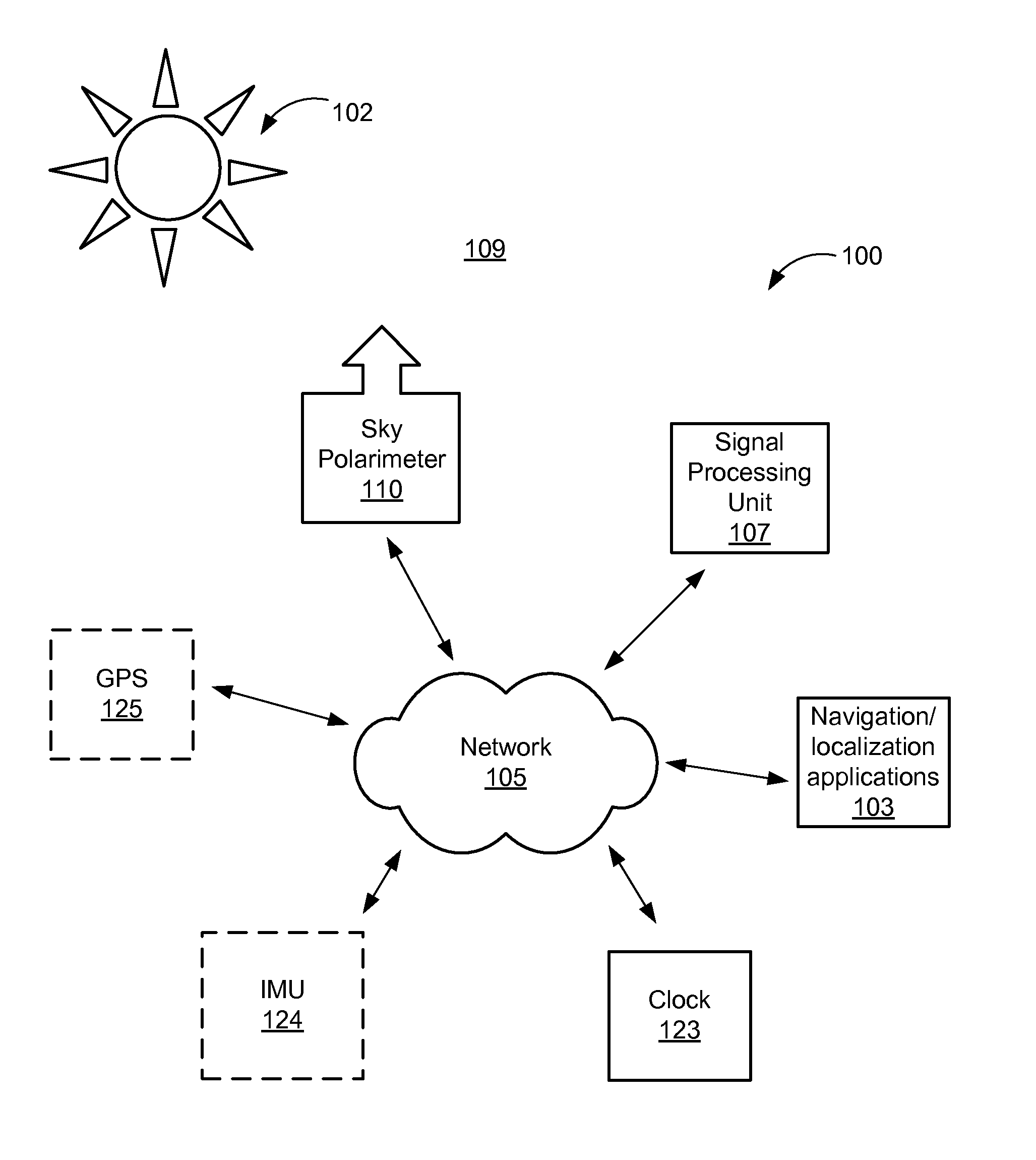
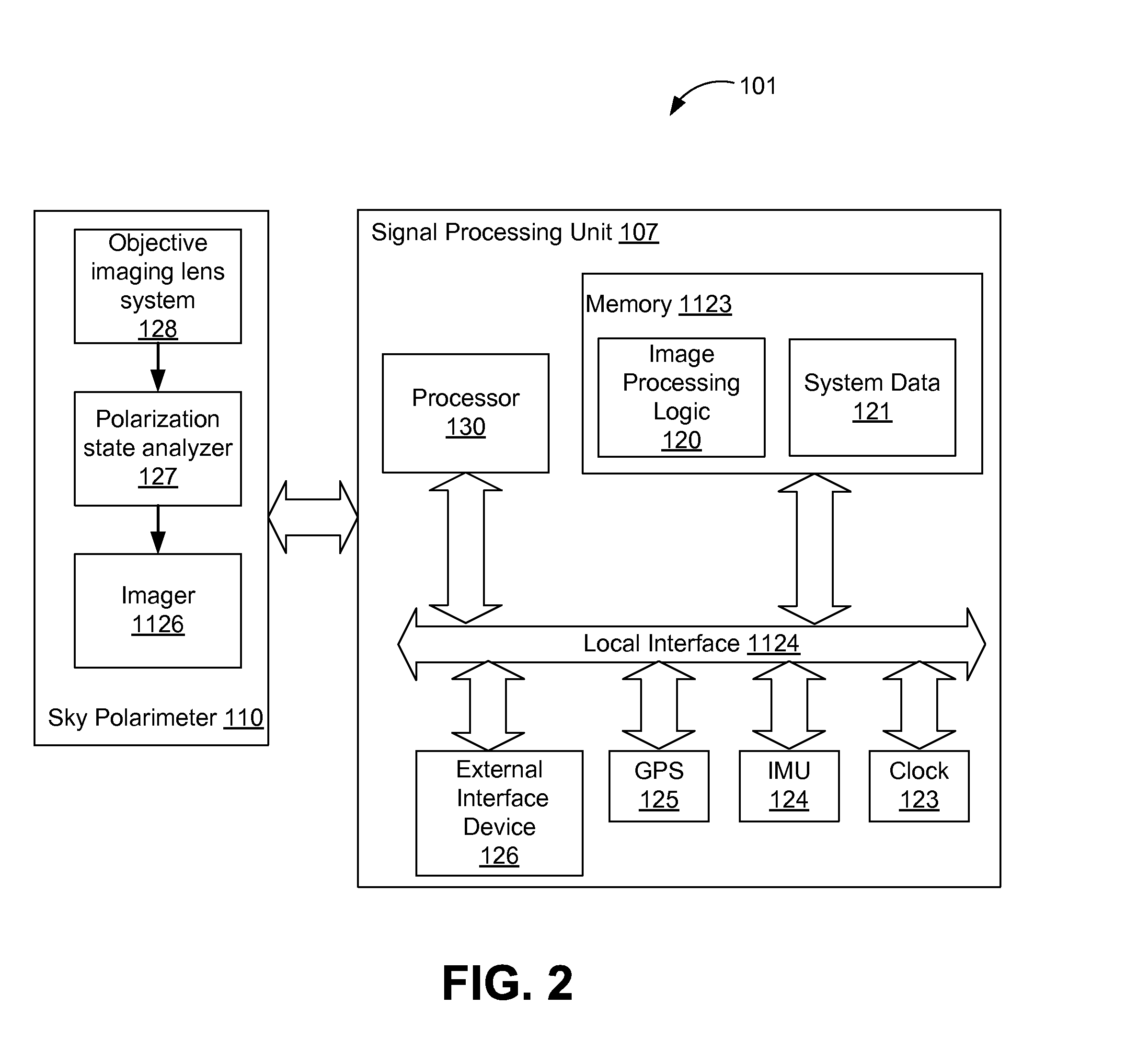
[0023]FIG. 1 illustrates a system 100 in accordance with an exemplary embodiment of the present disclosure. The system 100 comprises a sky polarimeter 110 and a signal processing unit 107 which collect and analyze images of the sky 109, respectively.

[0024]The sky polarimeter 110 comprises a video imaging device (not shown) for recording polarized images, such as a digital video camera that collects images in its field of view (FOV); in this case, the images recorded are of the sky 109, including the Sun 102, if visible. The sky polarimeter 110 transmits raw image data to the signal processing unit 107, which processes the data and performs navigation and / or localization analysis, as further discussed herein. Although FIG. 1 shows the sky polarimeter 110 and the signal processing unit 107 as two separate items, the sky polarimeter 110 and signal processing unit 107 are packaged into one device in certain embodiments.

[0025]The sky polarimeter sends raw image data (not shown) to the si...


PUM


Abstract

A system for determining a new orientation and/or position of an object comprises a sky polarimeter configured to record image data of the sky, a signal processing unit, and logic configured to receive and store in memory the image data received from the sky polarimeter. The logic calculates the Stokes parameters (S0, S1, S2,), DoLP, and AoP from the image data, detects obscurants and filters the obscurants (such as clouds and trees) from the image data to produce a filtered image. The logic is further configured to find the Sun and zenith in the filtered image, and to determine the roll, pitch, yaw, latitude and longitude of the object using the filtered image. A method for determining a new position/orientation of an object comprises recording raw image data using a sky polarimeter, calculating S0, S1, S2, DoLP, and AoP from the image data, detecting obscurants and filtering the obscurants from the image data to produce a filtered image, obtaining last known position/orientation data of the object, finding the Sun and zenith in the filtered image, and determining the roll, pitch, yaw, latitude and longitude of the object using the filtered image.

Description

REFERENCE TO RELATED APPLICATIONS[0001]This application claims priority to Provisional Patent Application U.S. Ser. No. 61 / 894,023, entitled “Sky Polarization and Sun Sensor for GPS-Denied Localization” and filed on Oct. 22, 2013, which is fully incorporated herein by reference.GOVERNMENT LICENSE RIGHTS[0002]This invention was made with government support under Contract Number N00014-12-M-0272 awarded by the Department of Defense. The government has certain rights in the invention.BACKGROUND AND SUMMARY[0003]Currently, in situations where Global Position System (GPS location information is not available, a user typically relies on dead reckoning localization (e.g., using inertial measurements from an inertial measurement unit (IMU)). Such localization analysis, however, is subject to drift and error accumulation. Yaw, for example, is typically calculated using a compass, which can be unreliable due to variations of the earth's magnetic field direction on the surface of the earth, me...

Claims


Application Information

Patent Timeline
IPC IPC(8): G01S3/786G06K9/20G06K9/00G06V10/147G06V20/00
CPCG01S3/7861G06K9/209G06K9/00671G01S3/7862G01S5/16G01S5/163G06V20/00G06V10/147G01C21/02G01C17/00G06V20/20G01S3/783G06T7/70G06T2207/20061G06T2207/30181H04N7/183
Inventor AYCOCK, TODD MICHAELCHENAULT, DAVIDLOMPADO, ARTHURPEZZANITI, LARRY J.
Owner POLARIS SENSOR TECH
Why Eureka
Try Eureka