Systems and methods for GNSS snr probabilistic localization and 3-d mapping

Active Publication Date: 2016-10-06
RGT UNIV OF CALIFORNIA
View PDF3 Cites 26 Cited by
  • Summary
  • Abstract
  • Description
  • Claims
  • Application Information

AI Technical Summary

Benefits of technology

The patent text describes a system and method for accurately localizing and mapping in urban environments using GNSS signals. The system uses a Bayesian approach to simultaneously localize and map using only GNSS data and geo-location data. The system addresses the challenges of GNSS localization in urban environments, where signal degradation is common. The text also discusses the use of obstacle detection and the problem of self-localization errors in some mapping solutions. The technical effects of the patent text include improved accuracy and efficiency in GNSS localization and mapping in urban environments, as well as a reduction in the effects of localization errors.

Problems solved by technology

However, GNSS localization quality is often degraded.
This degradation is especially prevalent in urban areas, including signal blockage and multi-path reflections from buildings, trees, terrain, and other obstacles.
However, existing methods for 3-D mapping of city environments are expensive or necessitate significant planning and surveying, such as using LiDAR surveying or aerial photography surveying.
However, existing methods rely on a collection of heuristics resulting in “hard” maps, with no notion of map uncertainty and no straightforward way to update the map in a principled, consistent manner when additional measurements become available.
Due to the complexity of mapping problems, some existing solutions rely on probabilistic techniques to estimate maps.
Without correction, such active mapping techniques can be plagued by self-localization errors (e.g., position / velocity errors, orientation errors), leading to a data association problem.

Method used


Image

  • Systems and methods for GNSS snr probabilistic localization and 3-d mapping
  • Systems and methods for GNSS snr probabilistic localization and 3-d mapping
  • Systems and methods for GNSS snr probabilistic localization and 3-d mapping

Examples


example 7

[0129]In Example 7, the subject matter of any one or more of Examples 5-6 optionally include wherein generating the navigation output is based on a plurality of prior map occupancy probabilities.

example 8

[0130]In Example 8, the subject matter of any one or more of Examples 5-7 optionally include wherein receiving the input GNSS data further includes receiving a plurality of GNSS receiver position uncertainty values.

[0131]In Example 9, the subject matter of any one or more of Examples 5-8 optionally include wherein generating the navigation output is based on an SNR measurement model, the SNR measurement model describing an expected relationship between a plurality of SNR measurements and a plurality of LOS / NLOS likelihoods.

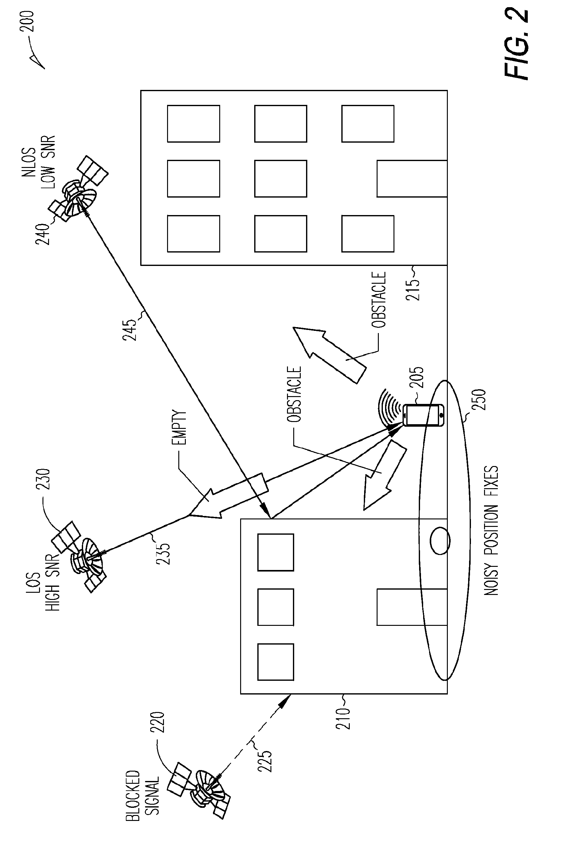
[0132]In Example 10, the subject matter of any one or more of Examples 5-9 optionally include wherein constructing the Bayesian network factor graph includes: tracing a plurality of rays through a plurality of voxels within a volumetric map, each of the plurality of rays representing a GNSS satellite ray from a GNSS receiver position to each of a plurality of GNSS satellites; storing a plurality of occupancy probabilities associated with each of the plurality of v...

example 15

[0137]In Example 15, the subject matter of any one or more of Examples 13-14 optionally include wherein the message passing schedule is synchronous.

[0138]In Example 16, the subject matter of any one or more of Examples 5-15 optionally include wherein determining mapping estimates includes holding position estimates constant.

[0139]In Example 17, the subject matter of any one or more of Examples 5-16 optionally include wherein: the Bayesian network factor graph nodes further include a plurality of position variable nodes; and the application of belief propagation includes passing messages between the plurality of position variable nodes and the plurality of SNR likelihood factor nodes.


PUM


Abstract

Various embodiments each include at least one of systems, methods, devices, and software for GNSS simultaneous localization and mapping (SLAM). The disclosed techniques demonstrate that simultaneous localization and mapping (SLAM) can be performed using only GNSS SNR and geo-location data, collectively termed GNSS data henceforth. A principled Bayesian approach for doing so is disclosed. A 3-D environment map is decomposed into a grid of binary-state cells (occupancy grid) and the receiver locations are approximated by sets of particles. Using a large number of sparsely sampled GNSS SNR measurements and receiver / satellite coordinates (all available from off-the-shelf GNSS receivers), likelihoods of blockage are associated with every receiver-to-satellite beam. Loopy Belief Propagation is used to estimate the probabilities of each cell being occupied or empty, along with the probability of the particles for each receiver location.

Description

RELATED APPLICATION AND PRIORITY CLAIM[0001]This application is a U.S. National Stage Filing under 35 U.S.C. 371 from International Application No. PCT / US2014 / 068220, filed on Dec. 2, 2014, and published as WO 2015 / 126499 A2 on Aug. 27, 2015, which is related and claims priority to U.S. Provisional Application No. 61 / 910,866, filed on Dec. 2, 2013 and entitled “PROBABILISTIC LOCALIZATION AND 3-D MAPPING BASED ON GNSS SNR MEASUREMENTS,” the entirety of each of which is incorporated herein by reference.STATEMENT OF GOVERNMENT SPONSORED SUPPORT[0002]The subject matter here was developed with Government support under Grant (or Contract) No. W911NF-09-D-0001 awarded by the U.S. Army Research Office. The Government has certain rights to the subject matter herein.BACKGROUND INFORMATION[0003]Global Navigation Satellite Systems (GNSS), such as GPS, are often used for geo-localization and navigation. These GNSS systems (e.g., Galileo, GLONASS, Beidou) consist of constellations of satellites i...

Claims


Application Information

Patent Timeline
IPC IPC(8): G01C21/00G01S19/22
CPCG01S19/22G01C21/005
Inventor IRISH, ANDREW T.ISAACS, JASON T.QUITIN, FRANCOISHESPANHA, JOAO P.MADHOW, UPAMANYU
Owner RGT UNIV OF CALIFORNIA
Why Eureka
Try Eureka