Evaluation Method of Solar Energy Utilization Potential in Urban High-density Areas Based on Low-altitude Photogrammetry

a solar energy utilization and high-density area technology, applied in the field of solar energy utilization potential assessment, can solve the problems of low analysis efficiency, uneven distribution of solar radiation on the surface of buildings, and difficult to cope with simple investigations and subjective calculations, so as to achieve the survey area of three-dimensional information quickly and efficiently, avoid high time-consuming, and avoid the effect of manual operation low efficiency

Active Publication Date: 2019-06-27
HARBIN INST OF TECH
View PDF3 Cites 41 Cited by
  • Summary
  • Abstract
  • Description
  • Claims
  • Application Information

AI Technical Summary

Benefits of technology

[0021]1. The invention fully utilizes the characteristics of low-altitude photogrammetry technology to acquire three-dimensional information in the survey area quickly, efficiently, and provides a method of low-cost, low-altitude urban high-density area data acquisition by combining consumer-grade drone and photogrammetry software. Compared with the traditional manual measurement, the invention adopts the UAV photogrammetry technology, avoids the high time-consuming and low efficiency of the manual operation, and effectively promotes the automation and standardization of the data collection. Compared with LiDAR technology, the invention adopts consumption-grade multi-rotor drone, greatly reduces the cost of data acquisition and has greater operability.
[0022]2. The invention adopts a curvature-based point cloud segmentation and feature detection method and a column model reconstruction to perform three-dimensional reconstruction of a building point cloud to obtain a building geometric model. It avoids the problem that it is difficult to determine the topological relationship between different contours after extracting building contours by traditional methods. It has high reconstruction accuracy and can well reflect the geometric structure characteristics of buildings.
[0023]3. The invention adopts the single-building geometric model of point cloud reconstruction to evaluate the solar energy utilization potential of the urban high-density area, avoids the insufficient consideration of the solar energy utilization potential of building facade by the existing technology, and is more comprehensive and accurate for the solar energy utilization potential evaluation.

Problems solved by technology

In urban high-density areas, buildings with different heights are densely distributed, which make the distribution of solar radiation on the surface of the building unevenly.
For the complex and variable survey environment of urban high-density areas, simple investigations and subjective calculations are difficult to cope with.
For the traditional manual measurement method, the analysis efficiency is low, and the data acquisition and post-processing are separated, which is difficult to meet the demand.
However, DSM has obvious characteristics of 2.5 D, which cannot depict the building facade well and cannot complete the calculation of solar radiation illumination of the facade.
At the same time, the LiDAR point cloud data processing process is complex, and the amount of manual interaction is large.
The cost of obtaining large area point cloud data is high and difficult to popularize.

Method used


Image

  • Evaluation Method of Solar Energy Utilization Potential in Urban High-density Areas Based on Low-altitude Photogrammetry

Examples


Embodiment Construction

[0025]The technical solution in the embodiments of the present invention will be clearly and completely described below with reference to the accompanying drawings in the embodiments of the present invention. Apparently, the described embodiments are merely some but not all of the embodiments of the present invention. All other embodiments obtained by a person of ordinary skill in the art based on the embodiments of the present invention without creative efforts shall fall within the protection scope of the present invention.

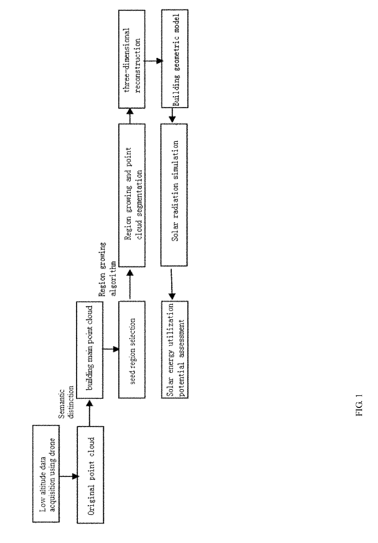
[0026]The invention utilizes low-altitude photogrammetry to obtain point cloud data in a high-density area of the city, and performs semantic division and three-dimensional reconstruction on the point cloud data through a parameterization tool to obtain a singular geometric model, so as to simulate and analyze the magnitude and dynamic changes of solar energy utilization potential obtained from the roof and facade of building in the same platform.

[0027]FIG. 1 il...


PUM


Abstract

The present invention proposes an evaluation method of solar energy utilization potential in urban high-density areas based on low-altitude photogrammetry, comprising the following steps: low-altitude data acquisition using drones, acquisition of three-dimensional point cloud data, screening of building subject points, selection of seed region, region growth and point cloud patch segmentation, three-dimensional reconstruction, building geometry model, solar radiation simulation and solar energy utilization potential assessment steps. The invention utilizes low-altitude photogrammetry to obtain point cloud data in a high-density area of the city, and performs semantic division and three-dimensional reconstruction on the point cloud data through a parameterization tool to obtain a singular geometric model. Therefore, the solar radiation and dynamic change obtained from the roof and facade of the building are simulated and analyzed in the same platform.

Description

CROSS-REFERENCES AND RELATED APPLICATIONS[0001]This application claims priority of Chinese Application No. 201711431061.3, entitled “An Evaluation Method of Solar Energy Utilization Potential in Urban High-density Areas Based on Low-altitude Photogrammetry”, filed Dec. 26, 2017, which is herein incorporated by reference in its entirety.FIELD OF THE INVENTION[0002]The invention relates to the technical field of solar energy utilization potential assessment, in particular to a method for evaluating the Solar Energy Utilization Potential in Urban High-density Areas Based on Low-altitude Photogrammetry.BACKGROUND OF THE INVENTION[0003]With the increasingly serious energy crisis and the rapid development of urbanization, the integrated design of photovoltaic and building will become an important trend of urban solar energy development. In urban high-density areas, buildings with different heights are densely distributed, which make the distribution of solar radiation on the surface of th...

Claims


Application Information

Patent Timeline
Patent Type & Authority Applications(United States)
IPC IPC(8): G06K9/00G01C11/02G06F17/50G06T7/187G06K9/62G06K9/46G06V10/56
CPCG06K9/00637G01C11/02G06F17/5004G06T7/187G06K9/6247G06K9/4652H02S20/22G06T2207/10028G06T2207/10032G06T2207/30184G06T7/136G06T7/90G06T2207/30176G01C11/04H02S99/00G06F2119/06G06F30/00G06F30/20Y02E10/50Y02B10/10G06V20/64G06V20/176G06V10/56G06F30/13G06F18/2135
Inventor SUN, CHENGHAN, YUNSONGPAN, YONGJIEDONG, QIQU, DAGANGJIA, YONGHENGLIU, LEI
Owner HARBIN INST OF TECH
Why Eureka
Try Eureka