Ionospheric delay correction method for leo satellite augmented navigation systems

a technology of augmented navigation and ionospheric delay, which is applied in the field of satellite positioning and navigation augmentation, can solve the problems of the complexity of theoretical models cannot be directly applied by gnss users, and the inability to ensure the accuracy of empirical models in all directions, so as to improve the accuracy, reliability and comprehensiveness of satellite navigation and positioning

Active Publication Date: 2019-09-05
WUHAN UNIV
View PDF6 Cites 21 Cited by
  • Summary
  • Abstract
  • Description
  • Claims
  • Application Information

AI Technical Summary

Benefits of technology

[0010]To solve the above-mentioned problems, the invention provides an ionospheric delay correction method for LEO satellite augmented navigation systems. According to the ionospheric delay correction method for LEO satellite augmented navigation systems, with an LEO spacecraft as a motion carrier platform, the earth ionosphere is continuously observed by loads carried by the LEO platform to obtain electron density distribution of the ionosphere, so that ionospheric delay correction parameter information is provided for satellite navigation system users to improve the accuracy, reliability and comprehensiveness of satellite navigation and positioning.
[0032]2) The system cost is low, specifically, a wide area or the global range can be covered with few satellites and ionospheric observation loads, and required ground infrastructure construction is reduced through a wireless satellite communication method, so that the system cost is reduced in these two aspects, automatic observation and data processing in a wide area or in the global range are achieved through the unified system, a unified navigation and positioning augmentation service is provided, and the overall system cost is reduced.
[0034]4) The operating orbits of the LEO satellites are located within the altitude range of the ionosphere, ionospheric events are monitored in real time through ionospheric state monitoring devices carried on the LEO satellites, the user receivers perform adaptive processing in the aspects of GNSS signal tracking, digital signal processing and positioning calculation based on the events, and thus the positioning accuracy and reliability are improved for the GNSS users.

Problems solved by technology

As a propagation medium, the ionosphere may reflect, refract, scatter and absorb radio waves at different wave bands, thus affecting communication and broadcast to a certain extent.
GNSS navigation signal delay caused by the ionosphere may reach several meters and even hundreds of meters, which affects the application mode and service scope of navigation systems and continuously promotes intensive study on the ionosphere.
Although theoretical models are beneficial for observing relative influences and possible changes of various input physical parameters, the theoretical models are too complex to be directly applied by GNSS users.
Although empirical models are simpler than theoretical models, the accuracy of the empirical models cannot be ensured in all regions of the world, and for users with high-precision positioning requirements and users in special regions, it is inadvisable to realize ionospheric correction only through empirical models.
Although the measurement models can better reflect the actual condition of the ionosphere than the empirical models, they are also based on observation data from the ground tracking stations and thus are limited by the distribution condition of the tracking stations.
Due to the deficiency or even absence of observation stations in ocean and desert regions, the accuracy of measurement models in these regions is not ideal and consequentially cannot meet requirements of all users.
Both GBAS and SBAS depend on a certain number of ground reference stations as well as corresponding infrastructure and communication facilities and consume a large quantity of human and material resources for operation and maintenance.
As the continuously operating reference stations (CORSs) used as reference stations cannot be constructed in air or on the sea, the ground local-area differential technique is not suitable for large-scale applications such as aerospace applications and marine applications, and only satellite-based wide-area augmentation systems can be used on these occasions to improve performance for GNSS users.
Both GBAS and SBAS rely on the continuously operating reference stations on the ground and consume a large quantity of manpower and material resources for operation and maintenance.

Method used


Image

  • Ionospheric delay correction method for leo satellite augmented navigation systems
  • Ionospheric delay correction method for leo satellite augmented navigation systems

Examples


Embodiment Construction

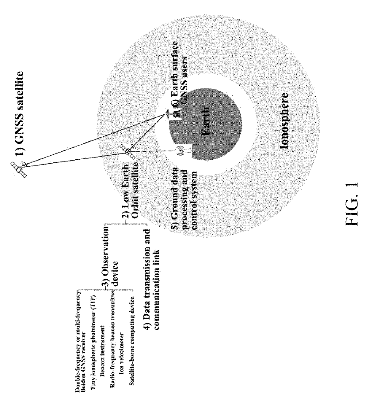
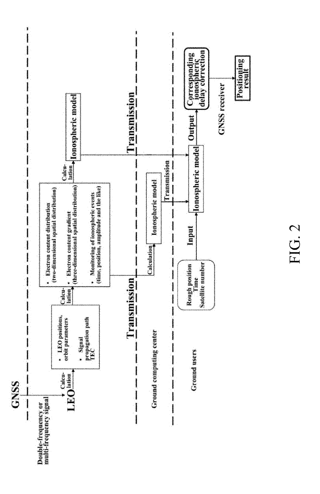
[0037]To make the purpose, technical scheme and advantages of the invention clearer and more understandable, a further detailed description of the invention is given as follows in combination with the drawings and embodiments. It can be appreciated that the specific embodiment in the following description is only used for explaining the invention and is not used for limiting the invention. On the contrary, the invention includes all substitutes, modifications and equivalent methods and schemes defined by the claims and based on the spirit and scope of the invention. Furthermore, in order to make the general public better understand the invention, certain detailed parts of the invention are described in detail as follows. Those skilled in the field can still completely understand the invention without a description of these detailed parts.

[0038]The invention is further described as follows in combination with the drawings and specific embodiment; however, the invention is not limited...


PUM


Abstract

The invention discloses an ionospheric delay correction method for LEO satellite augmented navigation systems for GNSS. According to the method, GNSS satellite navigation signals received by LEO GNSS receiver loads are used for providing ionospheric information for navigation augmentation for earth surface users. In the method, as a set of mobile navigation augmentation reference stations, LEO satellites continuously observe the global ionosphere to generate ionospheric delay correction information, and the ionospheric delay correction information is sent to the earth surface users to obtain augmented navigation performance. By adoption of the method, ionospheric delay correction data covering the whole world instead of covering certain areas and particularly ionospheric delay correction data covering the vast marine areas are obtained; ionospheric gradient data are provided; and compared with traditional approaches, ionospheric delay correction accuracy is higher than that of traditional approaches; ionospheric activities and events are monitored in orbit to provide complete ionospheric delay correction information.

Description

BACKGROUND OF THE INVENTIONTechnical Field[0001]The invention belongs to the technical field of the next generation of satellite positioning and navigation augmentation, and particularly relates to an ionospheric delay correction method for LEO satellite augmented navigation systems.Description of Related Art[0002]The ionosphere is a partially ionized atmosphere which is about 60-1000 km above the ground. Under the effect of solar ultraviolet, X-rays, high-energy particles and other cosmic rays, atmospheric molecules or atoms in the ionosphere are ionized to generate a large quantity of free electrons and positive and negative ions, which are important constituent parts of the sun-earth space environment. As a propagation medium, the ionosphere may reflect, refract, scatter and absorb radio waves at different wave bands, thus affecting communication and broadcast to a certain extent. In the present era during which global navigation satellite systems have rapidly developed, effectiv...

Claims


Application Information

Patent Timeline
Patent Type & Authority Applications(United States)
IPC IPC(8): G01S19/07G01S19/40
CPCG01S19/40G01S19/07G01S19/03G01S19/072
Inventor LIU, JINGBINCHEN, RUIZHILI, DERENCHEN, LIANGWANG, LEILIU, SHULUN
Owner WUHAN UNIV
Why Eureka
Try Eureka