Apparatus for determining agricultural relevant information

a technology for agricultural information and apparatus, applied in the field of apparatus for determining agricultural relevant information, can solve the problems of not having the accuracy to provide the farmer with the necessary information, the accuracy of information derived from satellite acquired imagery cannot be modelled at the required level, and the accuracy of ground based sensor acquired data cannot be very accurate, so as to achieve the effect of improving the means

Pending Publication Date: 2021-06-10
BASF AGRO TRADEMARKS GMBH
View PDF3 Cites 1 Cited by
  • Summary
  • Abstract
  • Description
  • Claims
  • Application Information

AI Technical Summary

Benefits of technology

This patent describes an improvement to agricultural information gathering by using a model to correct imaging. By comparing the corrected imaging to a ground-truth image, the model can fine-tune its parameters and provide accurate information even without ground-truth data. The correction is made by using a radiative transfer model or a dark object subtraction model, which can be adjusted based on real-value data like temperature, air pressure, humidity, and particle composition. This results in improved analysis of the imaging data.

Problems solved by technology

Information derived from satellite acquired imagery does not have the accuracy to provide the farmer with the necessary information (whether calibrated or not) to make decisions on how to manage their fields and the crops in them, because the atmosphere cannot be modelled at a required level.
Furthermore, ground based sensor acquired data can be very accurate, but does not provide the required coverage over different fields of a farm and within specific fields.

Method used


Image

  • Apparatus for determining agricultural relevant information
  • Apparatus for determining agricultural relevant information
  • Apparatus for determining agricultural relevant information

Examples


Embodiment Construction

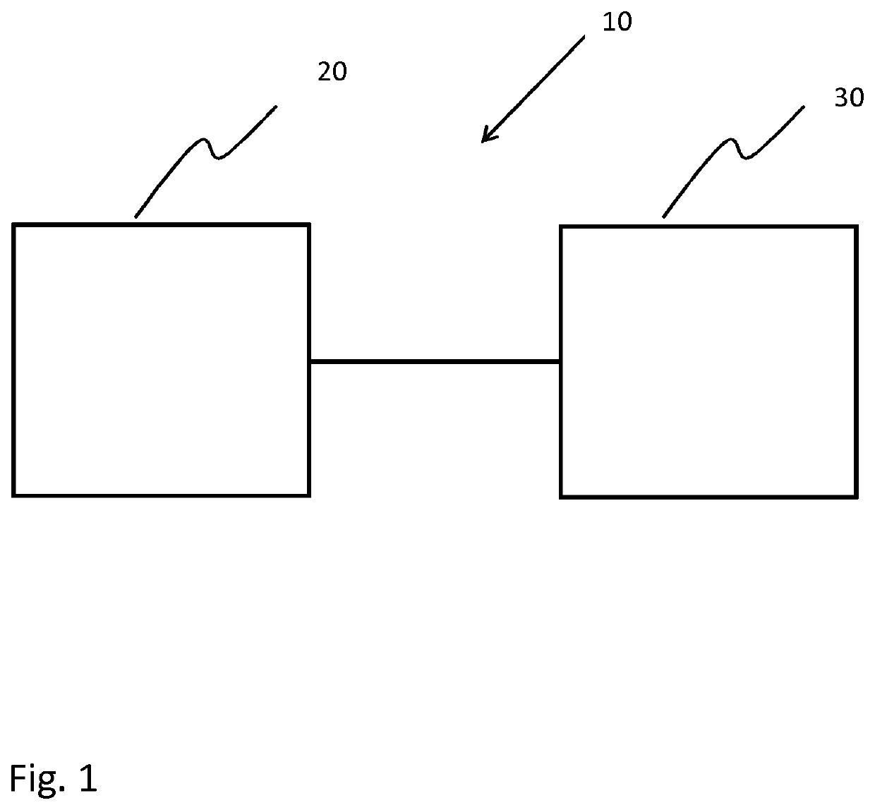
[0049]FIG. 1 shows an example of an apparatus 10 for determining agricultural relevant information in an agricultural environment. The apparatus 10 comprises an input unit 20 and a processing unit 30. The input unit is 20 configured to provide the processing unit 30 with at least one image of an agricultural area. The at least one image was acquired by at least one satellite and / or at least one aerial vehicle such that the at least one image was acquired through a substantial depth of the Earth's atmosphere. The at least one image corresponds with at least one area of the agricultural area such that each image of the at least one image corresponds to a different area of the agricultural area. The at least one image also comprises remotely acquired reflectance intensity data relating to a plurality of features on the ground. An image of the at least one image is of a first area of the agricultural environment. The input unit 20 is configured also to provide the processing unit 30 wit...


PUM


Abstract

The present invention relates to an apparatus for determining agricultural relevant information in an agricultural environment. It is described to provide (210) a processing unit with at least one image of an agricultural area. The at least one image was acquired by at least one satellite and / or at least one aerial vehicle such that the at least one image was acquired through a substantial depth of the Earth's atmosphere. The at least one image corresponds with at least one area of the agricultural area such that each image of the at least one image corresponds to a different area of the agricultural area. The at least one image comprises remotely acquired reflectance intensity data relating to a plurality of features on the ground. An image of the at least one image is of a first area of the agricultural environment. The processing unit is provided (220) with at least one sensor data relating to the first area of the agricultural environment. The at least one sensor data was acquired by at least one ground based and / or at least one near ground based sensor. The processing unit implements (230) a radiation propagation model of the atmosphere that utilizes at least one model parameter. The at least one model parameter comprises at least one atmospheric scattering coefficient. The processing unit determines (240) modified at least one model parameter. The determination comprising utilization of the radiation propagation model, the remotely acquired reflectance intensity data of the image of the first area and the at least one sensor data relating to the first area. The processing unit determines (250) at least one agricultural relevant information for an examination area of the at least one area. The determination utilizes the radiation propagation model, the modified at least one model parameter and an image of the at least one image that is of the examination area of the at least one area.

Description

FIELD OF THE INVENTION[0001]The present invention relates to an apparatus for determining agricultural relevant information, to a system for determining agricultural relevant information, and to a method for determining agricultural relevant information, as well as to a computer program element.BACKGROUND OF THE INVENTION[0002]The general background of this invention is the utilization of sensor acquired data to provide a farmer with an understanding of what is occurring in their agricultural fields. Information derived from satellite acquired imagery does not have the accuracy to provide the farmer with the necessary information (whether calibrated or not) to make decisions on how to manage their fields and the crops in them, because the atmosphere cannot be modelled at a required level. Furthermore, ground based sensor acquired data can be very accurate, but does not provide the required coverage over different fields of a farm and within specific fields.SUMMARY OF THE INVENTION[0...

Claims


Application Information

Patent Timeline
Patent Type & Authority Applications(United States)
IPC IPC(8): G01W1/12
CPCG01W1/12A01B79/005
Inventor PETERS, OLESELINGER, SANDRAROMMEL, THOMASANDREE-LABSCH, SILKE
Owner BASF AGRO TRADEMARKS GMBH
Why Eureka
Try Eureka