Ortho-image creation system, ortho-image creation method, survey marker used therefor and road survey method

a creation system and ortho-image technology, applied in the field of ortho-image creation system, can solve the problems of complicated surveying of the road by each surveyor and detection of cracks, and achieve the effect of easy detection

Pending Publication Date: 2022-11-17
MR SUPPORT INC
View PDF0 Cites 0 Cited by
  • Summary
  • Abstract
  • Description
  • Claims
  • Application Information

AI Technical Summary

Benefits of technology

[0034]As described above, according to the present invention, an ortho-image is created on the basis of a plurality of photographed images photographed by an unmanned aerial vehicle or a model aerial vehicle flying at an altitude of 20 meters or less above the ground, and thus it is possible to create an ortho-image in which the condition of a road surface and the location of plane elements around the road can be clearly distinguished. In the ortho-image created by the present invention, it is possible to clearly distinguish the places where cracks and patching have occurred in a road and the locations of plane elements including the edges of the road and division lines such as lane marking lines, and it is possible to detect each plane position in the periphery of a manhole in the longitudinal and transverse directions. In the road survey method of the present invention, by designating two designated points on the display unit on which the ortho-image is displayed, the distance between the two designated points can be easily detected. In the road survey method of the present invention, by designating a designated range on the display unit on which the ortho-image is displayed, the planar dimension of the designated range can be easily detected.

Problems solved by technology

In the past, cracking conditions were visually surveyed by surveyors, but it is very complicated for each surveyor to survey the road and detect cracks.

Method used


Image

  • Ortho-image creation system, ortho-image creation method, survey marker used therefor and road survey method
  • Ortho-image creation system, ortho-image creation method, survey marker used therefor and road survey method
  • Ortho-image creation system, ortho-image creation method, survey marker used therefor and road survey method

Examples


Embodiment Construction

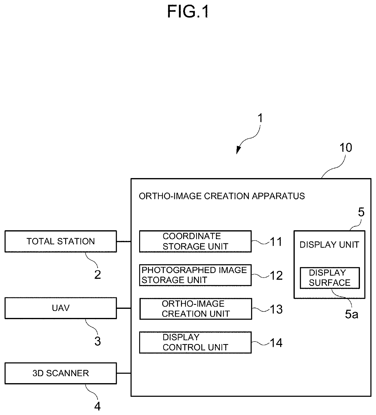
[0067]Hereinafter, embodiments of the present invention will be described with reference to the drawings. An ortho-image creation system 1 according to an embodiment of the present invention has a total station 2 installed at a known point (e.g., a reference point), a UAV (unmanned aerial vehicle) 3 as a photography device, a 3D scanner 4 (three-dimensional scanning device) installed at the known point, and an ortho-image creation apparatus 10 wirelessly connected to the total station 2, the UAV 3, and the 3D scanner 4.

[0068]The total station 2 emits ranging light toward each point on a surface of a road, receives reflected light reflected at each point, acquires three-dimensional coordinates of each point relative to the known point on the basis of the number of times of oscillation of a light wave from the light emission to the light reception, and supplies the three-dimensional coordinates to an ortho-image creation system 10. In this embodiment, the total station 2 is used to ac...


PUM


Abstract

When repairing a road, it is possible to easily conduct a survey on the road condition at the time of starting repair. The ortho-image creation method of the present invention includes a coordinate acquisition step to acquire three-dimensional coordinates of a plurality of survey markers 6, a photography step to photograph a plurality of photographed images of the plurality of survey markers 6 by a UAV 3 flying at an altitude of 20 meters or less above the ground in such a manner that each survey marker 6 is included in at least two of the photographed images, and an ortho-image creation step to create an ortho-image on the basis of the three-dimensional coordinates of each feature point acquired by the coordinate acquisition step and the plurality of photographed images photographed by the photography step.

Description

TECHNICAL FIELD[0001]The present invention relates to an ortho-image creation system and an ortho-image creation method that create an ortho-image on the basis of photographed images photographed from the sky by, for example, an unmanned aerial vehicle, and a survey marker used therefor and a road survey method.BACKGROUND ART[0002]Conventionally, when damage such as cracks occurs on a surface of asphalt pavement that constitutes a surface layer of a road, it is necessary to repair the road.[0003]In order to repair a road, various surveys on the road condition and the locations of plane elements including the edges of the road and division lines such as lane marking lines at the time of starting repair are conducted. For example, a survey is conducted to determine the place and amount of cracks that have occurred on the road. In the past, cracking conditions were visually surveyed by surveyors, but it is very complicated for each surveyor to survey the road and detect cracks. Therefo...

Claims


Application Information

Patent Timeline
Patent Type & Authority Applications(United States)
IPC IPC(8): G06T7/62G01B11/30
CPCG06T7/62G01B11/30G06T2207/10032E01C23/01G01C7/02G01C11/04G01C11/06G01C15/00G01C15/06G01N21/88G06T7/73G06T2207/30184G01B11/25
Inventor KUSAKI, SHIGEOMORI, TAKAMITSU
Owner MR SUPPORT INC
Why Eureka
Try Eureka