Self-contained positioning method and system thereof for water and land vehicles

a self-contained positioning and vehicle technology, applied in the direction of process and machine control, navigation instruments, instruments, etc., can solve the problems of reducing the effectiveness of the inertial navigation system in land and the inability of the gps receiver to provide continuous positioning information, and achieve the effect of low power and low cos

Inactive Publication Date: 2002-10-01
AMERICAN GNC
View PDF6 Cites 165 Cited by
  • Summary
  • Abstract
  • Description
  • Claims
  • Application Information

AI Technical Summary

Benefits of technology

(1) Miniature, light wei

Problems solved by technology

Unfortunately, GPS is vulnerable to jamming and shadowing, especially on land and in water, so that a GPS receiver is not often able to provide continuous p

Method used


Image

  • Self-contained positioning method and system thereof for water and land vehicles
  • Self-contained positioning method and system thereof for water and land vehicles
  • Self-contained positioning method and system thereof for water and land vehicles

Examples


Embodiment Construction

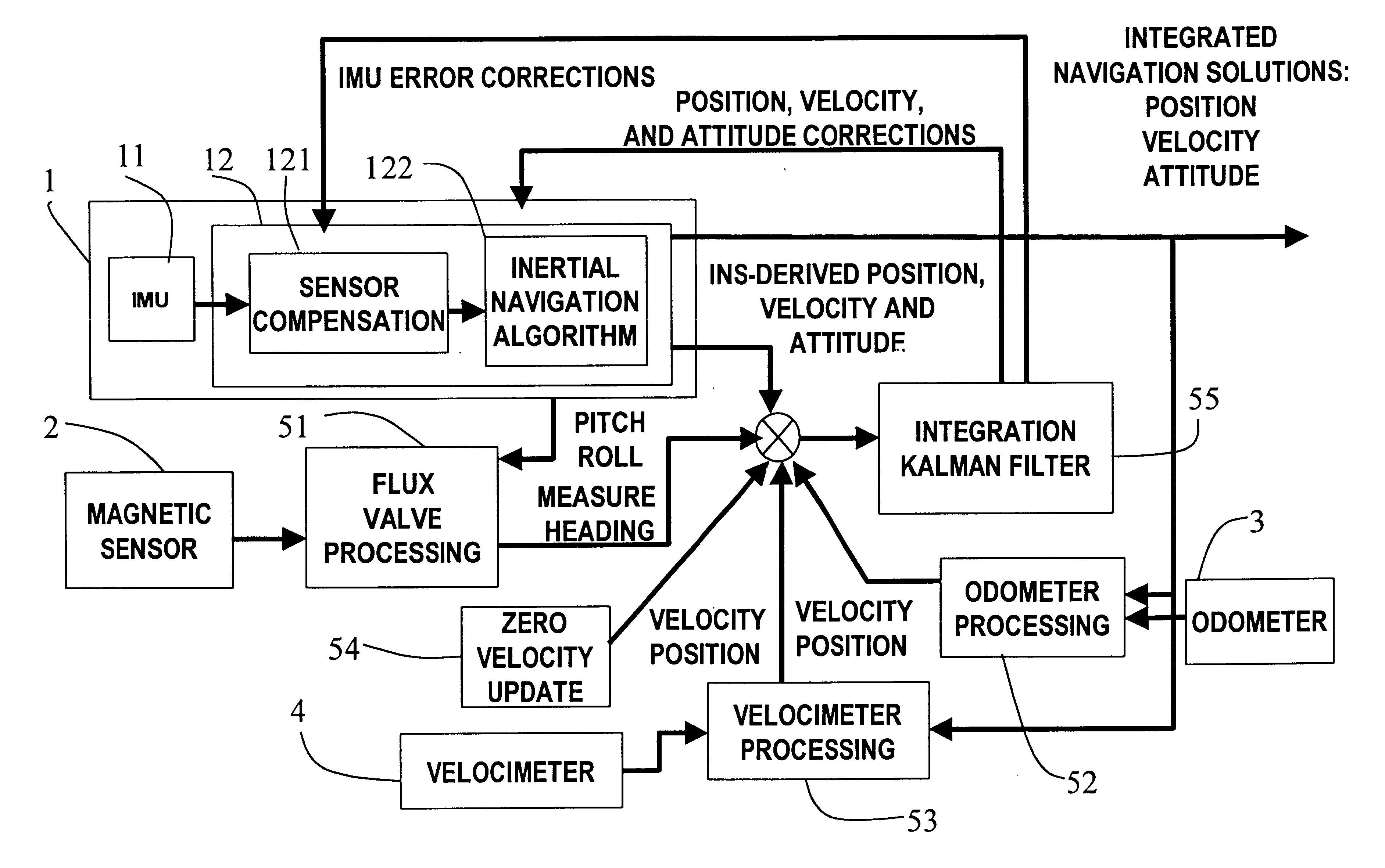
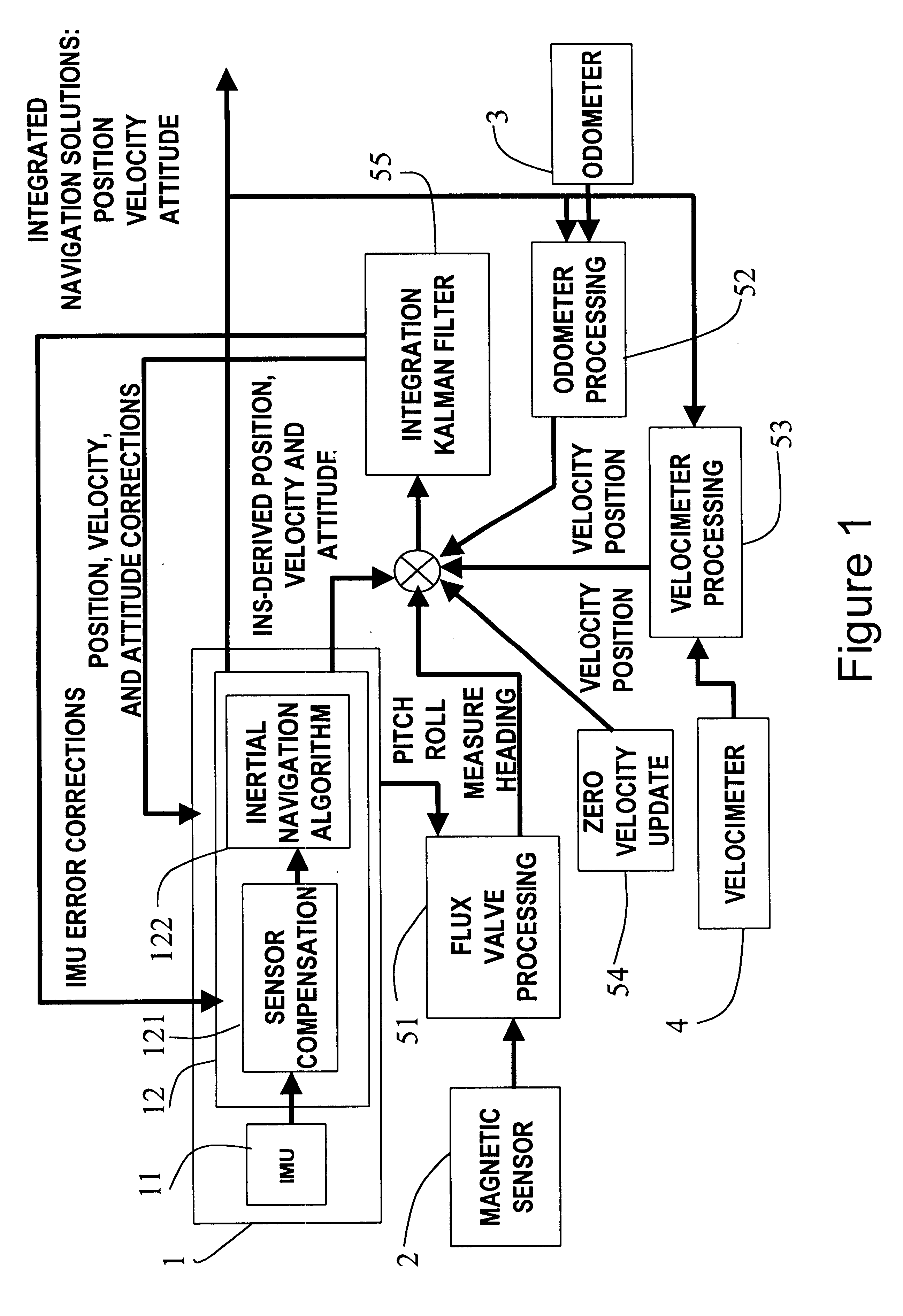
The present invention provides a self-contain positioning method and system for land and water vehicles, wherein output signals of an inertial measurement unit, an odometer, a velocimeter, and a magnetic sensor are processed to obtain highly accurate position measurements of the vehicle on land and in water.

Conventionally, an inertial navigation system (INS) is a self-contain system. However, a high accurate INS is too expensive to use in commercial applications. A low cost INS need GPS or radar updates to provide high accurate position information at cost of lack of the self-contained feature.

It is possible to build a low-cost, low-weight, and small-size integrated navigation system. In the present invention, an inertial navigation system is built on the micro MEMS IMU that is the core of a position determination system. To compensate the error of the INS, multiple navigation sensors are integrated into the system. A magnetic sensor is used as an Earth's magnetic field sensor to me...


PUM


Abstract

A positioning method and system for water and land vehicles is disclosed for highly accurate and self-contained operation. In which, an inertial navigation system (INS) is built on the micro MEMS (MicroElectroMechanicalSystem) IMU that is the core of the position determination system. To compensate the error of the INS, multiple navigation sensors are integrated into the system. The magnetic sensor is used as a magnetic field sensor to measure the heading of the vehicle. The odometer is used to measure the distance when the vehicle is on land. An automated Zero velocity updating method is used to calibrate the ever increasing INS errors. When the vehicle is in the water, a velocimeter is used to measure water speed for the INS aiding.

Description

BACKGROUND OF THE PRESENT INVENTION1. Technical Field2. Field of the Present InventionThe present invention relates to a positioning method and system for land and water vehicles, and more particularly to a self-contained positioning method and system for land and water vehicles, wherein output signals of an inertial measurement unit, an odometer, a velocimeter, and a magnetic sensor are processed to obtain highly accurate position measurements of a vehicle on land and in water.3. Description of Related ArtsNowadays, GPS (Global Positioning System) is the most accurate navigational system available for commercial uses. The GPS is a satellite radio-navigation system, which is owned, deployed, and operated by the U.S. Department of Defense, but is available for commercial uses around the world.GPS has 21 GPS satellites and three spare satellites in orbit at 10,600 miles from the Earth. The satellites are spaced so that from any point on Earth, four satellites will be visible above the...

Claims


Application Information

Patent Timeline
IPC IPC(8): G01C21/10G01C21/16
CPCG01C21/165G01C21/1654
Inventor MCCALL, HIRAMLIN, CHING-FANG
Owner AMERICAN GNC
Why Eureka
Try Eureka