Method for operating a navigation system

a navigation system and navigation system technology, applied in navigation instruments, maps/plans/charts, instruments, etc., can solve problems such as unsatisfactory levels, data or information that may be of interest are located outside that particular tile, and achieve the effect of being more flexibl

Inactive Publication Date: 2002-10-29
TOMTOM GLOBAL CONTENT
View PDF6 Cites 53 Cited by
  • Summary
  • Abstract
  • Description
  • Claims
  • Application Information

AI Technical Summary

Benefits of technology

It is the object of the present invention to make an improved method of the above type available which overcomes the aforementioned disadvantages and achieves a more-flexible display that is closer to reality.
This has the advantage that on the one hand the device that calls up the data need not itself know the size of the tile, and a tile can merely be called up by indicating a pair of coordinates, and on the other hand, data pertaining to geographic elements that overlap the edge of the tile can also be present, adjacent to the edge of the tile, outside the tile. "Clipping" at the boundaries of tiles is unnecessary. In addition, a "map", regardless of the size of the tile, can be assembled for display on the display device, so that tile boundaries need not necessarily be visible in the display. In addition, lapses in the map display that are otherwise caused by rounding errors in "clipping" algorithms at the tile boundaries are avoided.

Problems solved by technology

Furthermore, on access by means of the navigation module, for instance for internal route calculation, and control panel computers, for instance for generating a display of a detail of the digital map base on the display device, access conflicts can occur.
It has been found that standardization and unification of the classification of map elements is possible only on a very unsatisfactory level that cannot be used to generate a display.
On the other hand, it is a major disadvantage of tiles that data or information that may be of interest are located outside that particular tile or are unavailable at the edge of the tile, because they have been cut off by so-called "clipping" and were not also transmitted.
Hence this method for determining the tile edge coordinates (called clipping) is complicated and vulnerable to error.

Method used


Image

  • Method for operating a navigation system
  • Method for operating a navigation system

Examples


Embodiment Construction

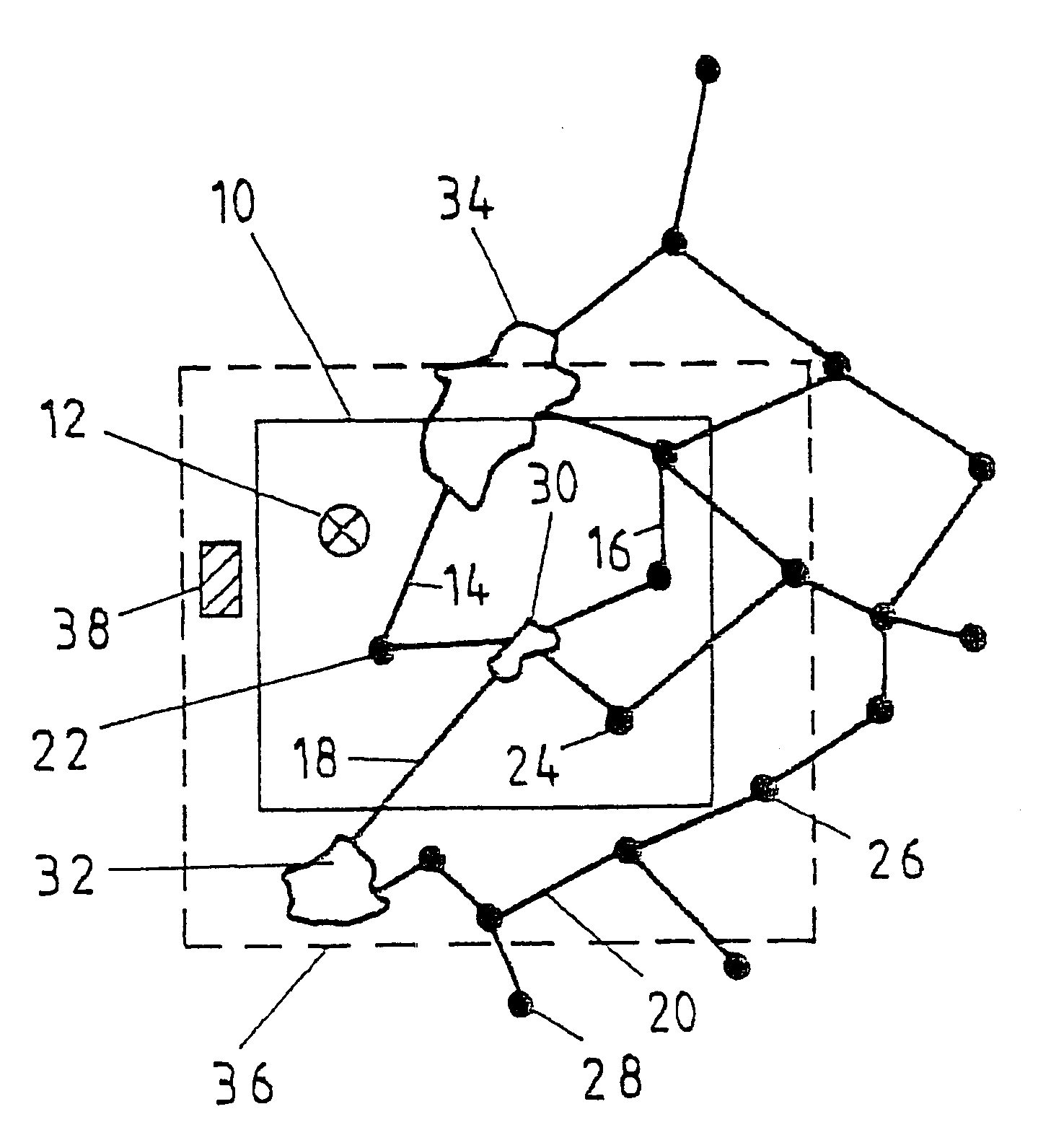
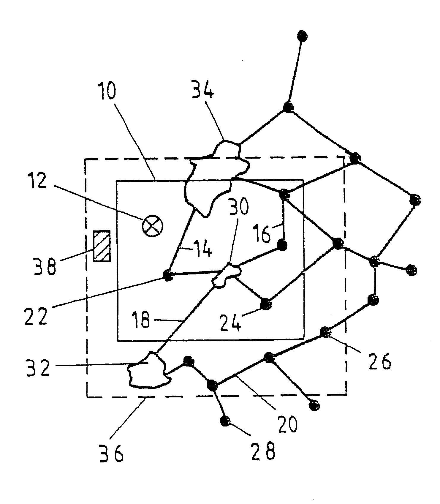
In the division, shown in the sole drawing FIGURE, of a digital map base into various tiles, only one tile 10 is explicitly shown. Additional tiles adjoin this tile 10 at the top, bottom, right and left accordingly. When navigation data are called up from the digital map base within a navigation system, only one coordinate 12 is transmitted. In the device that manages the digital map base, this coordinate is assigned to the tile 10, within which this coordinate point is located. All the data of geographic elements are thereupon collected together and transmitted to the calling device, such as a control panel with a display device. These data pertain to or describe geographic elements, such as streets and roads 14, 16, 18, 20, junctions 22, 24, 26, 28 or urban areas 30, 32, 34. Here the roads 14, 16, junctions 22, 24 and the urban area 30 are located entirely inside the tile 10, while the road 18 and the urban area 34 overlap the tile boundary.

According to the invention, all the data...


PUM


Abstract

The invention relates to a method for operating a navigation system comprising a digital map base, which is a representation of actual geographical areas and which contains data of geographical elements. The navigation-system also comprises a unit, which retrieves and processes the data, such as an operating unit provided with a display device. The data in the digital map base is combined in the form of geographically defined page frames. When requesting a page frame from the digital map base, data of geographical elements which extend beyond the edge of the page frame is transferred in such a manner that data pertaining to these geographical elements located outside of the requested page frame is also compiled and transferred.

Description

The present invention relates to a method for operating a navigation system, having a digital map base which includes a reproduction of actual geographic regions and data of geographic elements, as well as having a device, such as a control panel with a display device that calls up the data and processes them, the data being summarized in the digital map base in the form of geographically defined tiles, as generically defined by the preamble to claim 1.PRIOR ARTIn means of locomotion, such as motor vehicles, aircraft or ships, permanently installed navigation systems rapidly, simply and securely guide an operator of the means of locomotion toward a desired destination, without having to plan a route in advance at great effort and without having to obtain and study map material accordingly beforehand. To that end, navigation data are stored as a digital map base in the navigation system, for instance on CD-ROM, and based for instance on maps, regional maps or road maps. The navigatio...

Claims


Application Information

Patent Timeline
Patent Type & Authority Patents(United States)
IPC IPC(8): G01C21/28G01C21/32G09B29/10G09B29/00G01C21/00G08G1/0969
CPCG01C21/32G09B29/10G01C21/3889G01C21/3881
Inventor WINTER, STEPHANJUNG, THOMASHESSING, BERNDNORDSIEK, WALTERBINNEWIES, OLAFFABIAN, THOMASRENTEL, BETTINAOTTE, DIRKTIEMANN, DIRK
Owner TOMTOM GLOBAL CONTENT
Why Eureka
Try Eureka