Method for producing 3D perspective view avionics terrain displays

a technology of avionics and terrain display, applied in the field of vehicle display, can solve the problems of large computational workload, large computational burden, and difficulty in performing the enormous computational tasks associated with providing detailed, and achieve the effects of significantly reducing computational load, and reducing computation and data load

Inactive Publication Date: 2005-03-01
HONEYWELL INT INC
View PDF13 Cites 71 Cited by
  • Summary
  • Abstract
  • Description
  • Claims
  • Application Information

AI Technical Summary

Benefits of technology

The instant invention addresses the aforementioned difficulties by significantly reducing the computation and data load for producing the terrain display for flight management systems. This is accomplished through the use of intelligent level of detail control that computes and displays terrain and dynamic on-terrain perspective projection lines and distance rings aligned with the aircraft heading for depth perceptio

Problems solved by technology

There are significant challenges to producing such displays since such displays frequently must cover a large area of terrain in order to show look-ahead distance compatible with visibility range for typical approach, landing, and take-off phases of flight.
Generating the displays in real time with a large amount of terrain data presents significan

Method used


Image

  • Method for producing 3D perspective view avionics terrain displays
  • Method for producing 3D perspective view avionics terrain displays
  • Method for producing 3D perspective view avionics terrain displays

Examples


Embodiment Construction

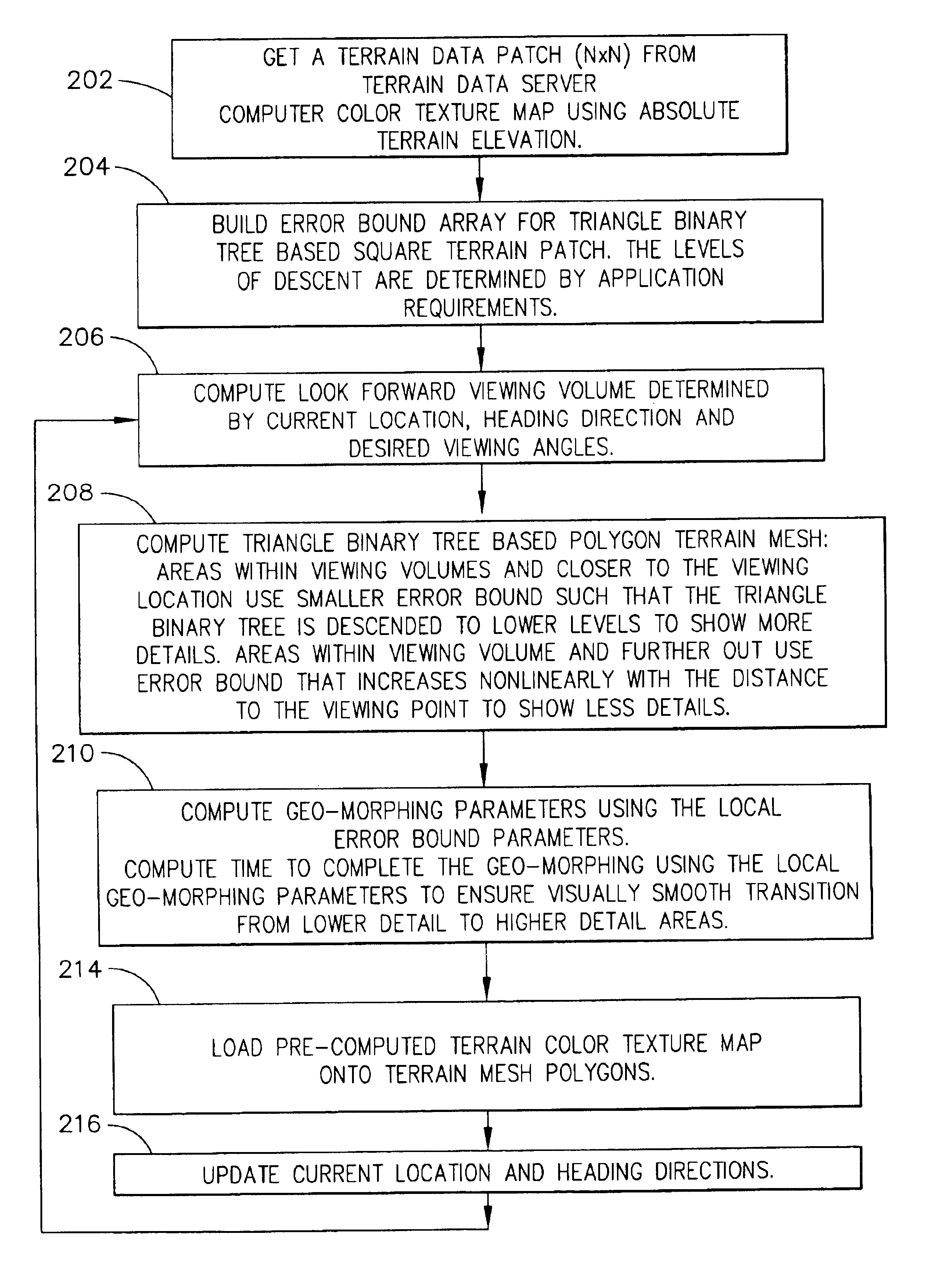
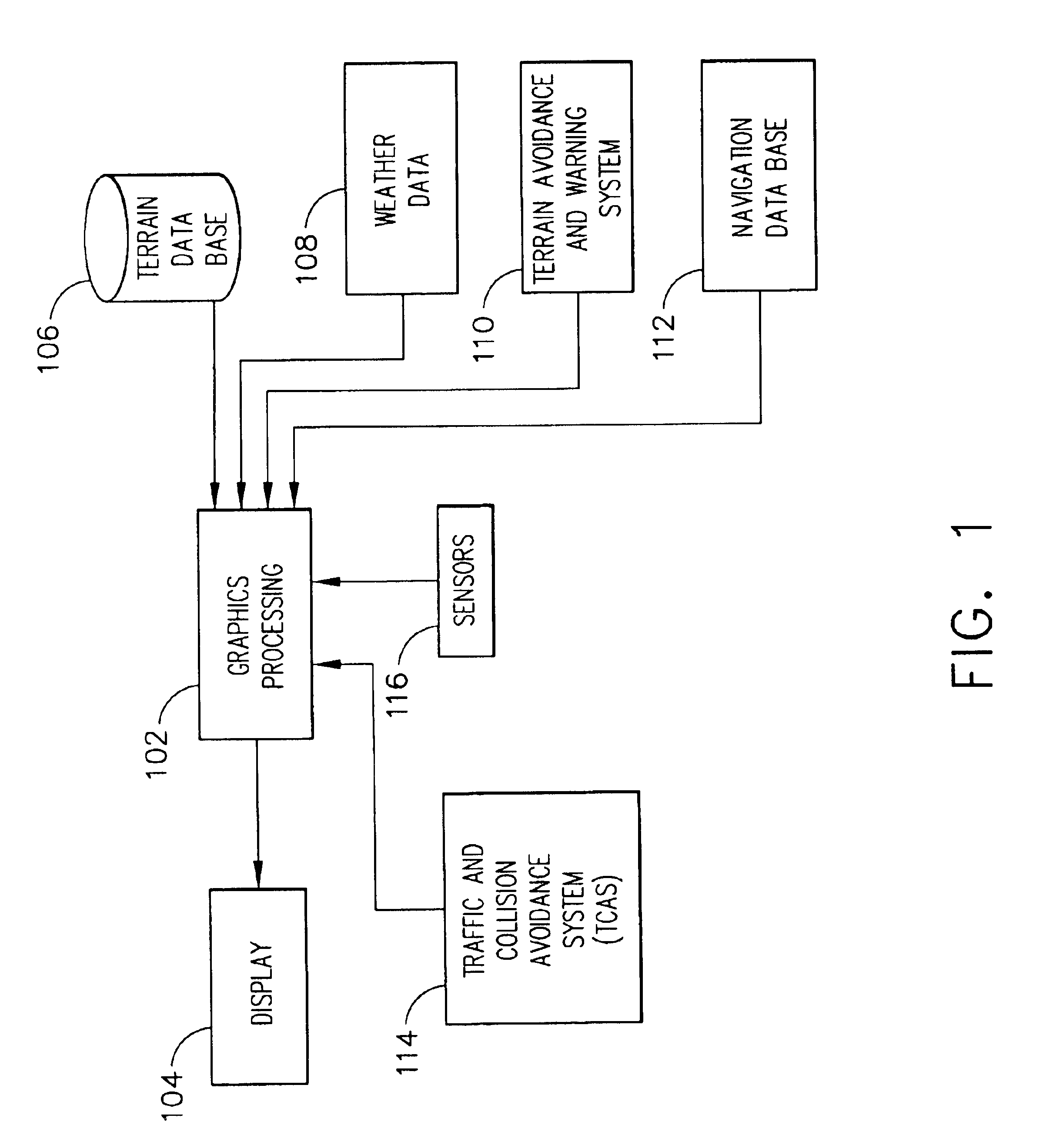
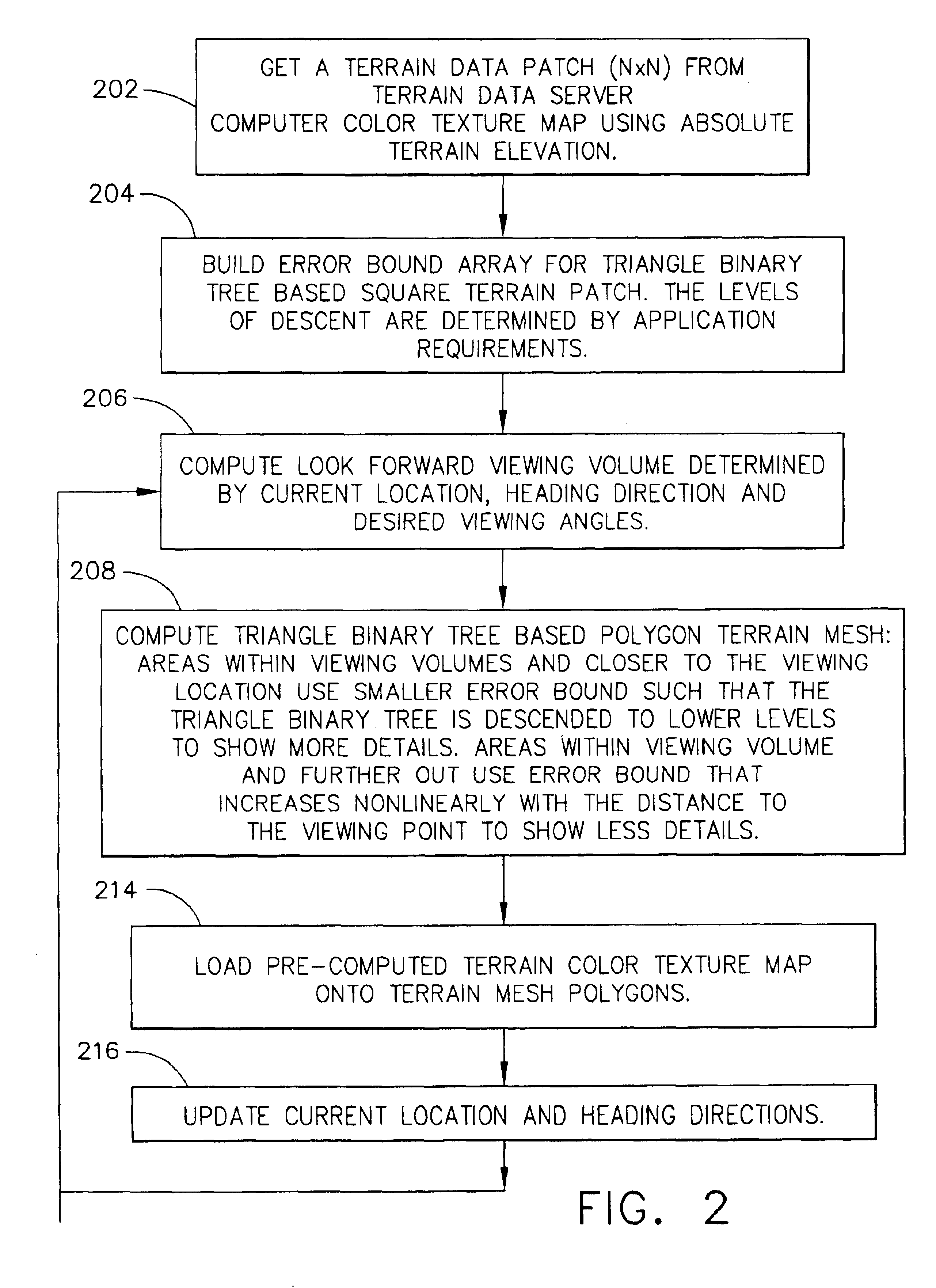
The present invention may be described in terms of functional block diagrams and various processing steps. It should be appreciated that such functional blocks may be realized in many different forms of hardware, firmware, and / or software components configured to perform the various functions. For example, the present invention may employ various integrated circuit components, e.g., memory elements, digital signal processing elements, look-up tables, and the like, which may carry out a variety of functions under the control of one or more microprocessors or other control devices. Such general techniques are known to those skilled in the art and are not described in detail herein. Moreover, it should be understood that the exemplary process illustrated may include additional or fewer steps or may be performed in the context of a larger processing scheme. Furthermore, the various methods presented in the drawing Figures or the specification are not to be construed as limiting the orde...


PUM


Abstract

Methods for generating information for displaying terrain on an aircraft display system that significantly reduces the computation and data load for producing the terrain display. This is accomplished through the use of intelligent level of detail control that computes and displays terrain and dynamic on-terrain perspective projection lines and distance rings aligned with the aircraft heading for depth perception and relative altitude awareness. The terrain details are processed and displayed in a manner that shows all significant terrain features, e.g., peaks, towers, and the like, but through the use of nonlinear error bound geometric morphing, coupled with triangle binary tree based terrain mesh generation, the polygon count, and thus the computational load, are significantly reduced, while visual fidelity is maintained.

Description

FIELD OF THE INVENTIONThe present invention relates to a display for a vehicle, and more particularly to a display for an aircraft flight management system that also displays terrain features.BACKGROUND OF THE INVENTIONModern map displays, particularly those used in aircraft for flight planning and monitoring, are capable of displaying a considerable amount of information such as flight planning information and terrain information. The terrain information consists of situational awareness (SA) terrain and terrain cautions and warnings that, among other things, may indicate where the aircraft may potentially impact terrain. The flight planning information consists of flight path information, altitude information and other information useful to a pilot or crewmember in following and anticipating the path and altitude of the aircraft over the ground.Three dimensional perspective representations of terrain or out-of-window displays provide better spatial understanding and situation awar...

Claims


Application Information

Patent Timeline
IPC IPC(8): G06T17/20G06T15/20G06T15/10
CPCG06T15/04G06T17/20Y10S707/99936G06T2210/36
Inventor HE, GANG
Owner HONEYWELL INT INC
Why Eureka
Try Eureka