GPS device with compass and altimeter and method for displaying navigation information

a technology of navigation information and compass, which is applied in the field of electronic navigation devices, can solve the problems of limiting the approach to a pair of locations, cumbersome carrying multiple such devices, and inability of conventional gps units to determine heading or direction information

Inactive Publication Date: 2005-03-01
GARMIN
View PDF13 Cites 69 Cited by
  • Summary
  • Abstract
  • Description
  • Claims
  • Application Information

AI Technical Summary

Benefits of technology

The addition of the magnetic and tilt sensors utilized by the present invention allows for a compass setting to be displayed at any time, with the unit in a wide variety of orientations, even when the user is standing still and moving at a slow speed. The addition of these sensors also allows for a moving map display to be realized when the user is standing still. In this regard, conventional GPS navigational devices already provide moving map displays, but only when the unit is in motion and the GPS heading information is available. Thus, it will be appreciated that, with the present invention, even when a user is standing still, a heading may be determined, and th

Problems solved by technology

However, conventional GPS units are unable to determine heading or direction information when the user of the GPS device is not traveling at a sufficient speed, typically in the order of 4 mph or great

Method used


Image

  • GPS device with compass and altimeter and method for displaying navigation information
  • GPS device with compass and altimeter and method for displaying navigation information
  • GPS device with compass and altimeter and method for displaying navigation information

Examples


Embodiment Construction

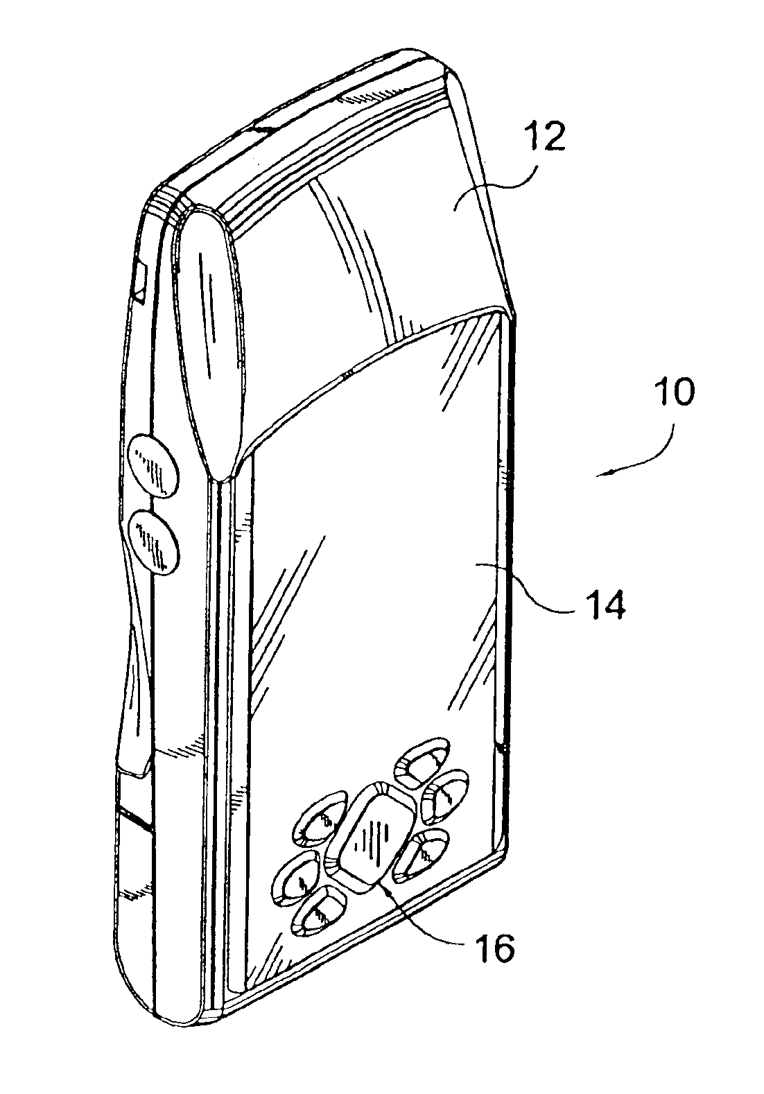
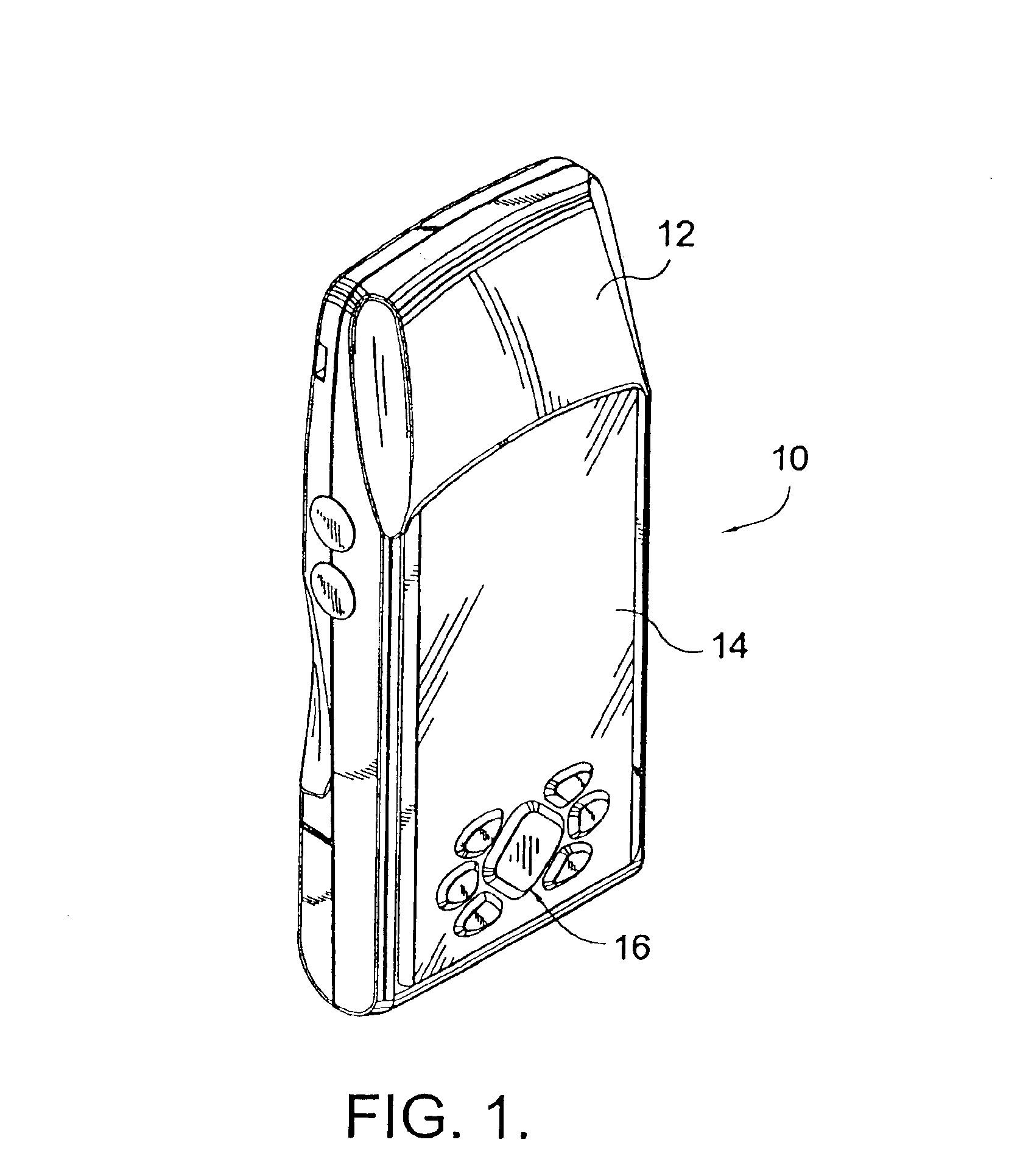
With reference to FIG. 1, a navigation device of the present invention is denoted generally by reference numeral 10. Navigation device 10 has a housing 12, preferably formed of plastic, a display 14, and an input 16, preferably a keypad input. Other known inputs, such as a touch screen, may be utilized additionally or alternatively. The housing 12 is preferably sized to be portable and handheld, and to fit at least substantially fit within the palm of a single hand of a user.

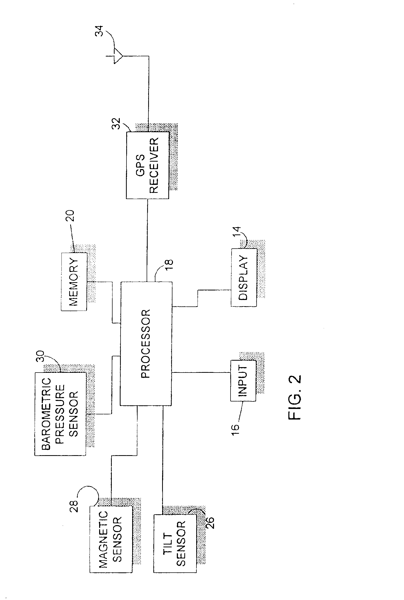
With reference to FIG. 2, navigation device 10 has a processor 18. Connected to processor 18 are a memory 20, the display 14, the input 16, a two-axis tilt sensor 26, a three-axis magnetic sensor 28, and a barometric pressure sensor 30. Additionally, a GPS receiver 32 is connected to the processor 18. An antenna, such as a GPS patch antenna for receiving GPS signals 34 is connected to the GPS receiver 32. A power source, such as batteries, or a battery pack (not shown), will be utilized to supply power to the va...


PUM


Abstract

A portable, handheld electronic navigation device includes an altimeter, a compass, and a GPS unit. An internal memory stores cartographic data, for displaying the cartographic data on a display of the navigation device. Accordingly, the device is capable of displaying cartographic data surrounding a location of the unit as determined by the altimeter. Additionally, through operation of an input, a user can cause the display to move, and thus display additional cartographic information, in the direction of the compass heading even when the user of the device is standing still. Furthermore, through utilization of a clock, such as the GPS clock, a user can determine altitude changes over time. Also, the altimeter of the navigation may be calibrated with altitude information entered by a user, with altitude information obtained from the cartographic or with altitude information derived from GPS.

Description

BACKGROUND OF THE INVENTION1. Field of the InventionThe present invention is directed to an electronic navigation device. More particularly, the present invention is directed to a handheld electronic navigation device, having combined in a single handheld housing a GPS unit, an electronic compass, and an altimeter.2. Description of the Related ArtHandheld navigation devices are well known, widely used, and are becoming increasingly popular. For example, GPS units, which have the ability to calculate a position and display map, route, and location information are becoming increasingly popular. Conventional GPS units also have the ability to calculate a user's heading, or direction of travel, by determining the movement of a user over time. However, conventional GPS units are unable to determine heading or direction information when the user of the GPS device is not traveling at a sufficient speed, typically in the order of 4 mph or greater.Accordingly, an outdoor enthusiast (such as ...

Claims


Application Information

Patent Timeline
IPC IPC(8): G01C21/20
CPCG01C21/20
Inventor BEASON, LAWRENCE W.LAVERICK, DAVID J.OLIVIER, TRACYBURGETT, SCOTT
Owner GARMIN
Why Eureka
Try Eureka