Portable navigation device and system, and online navigation service in wireless communication network

a wireless communication system and portable communication technology, applied in direction finders, navigation instruments, instruments using radio waves, etc., can solve the problems of inability to use as a guide or guidance for the inability of the user of the portable communication device to confirm his/her present position and destination, and the inability to provide conventional map information services. to provide the indication of the destination, to achieve the effect of convenient handling and operation of navigation functions

Inactive Publication Date: 2005-03-15
YAMAHA CORP
View PDF18 Cites 97 Cited by
  • Summary
  • Abstract
  • Description
  • Claims
  • Application Information

AI Technical Summary

Benefits of technology

[0012]It is an object of the invention to provide a portable communication device that is easy to operate for users of all ages and that can display a clear and recognizable navigation image on the screen without using ‘expensive’ graphic processing. Herein, the portable communication device having a navigation function is applicable to navigation systems, in particular, wireless communication networks incorporating servers for providing online navigation services.
[0014]Thus, it is possible to create images for navigation that are appropriately displayed on the screen and are recognizable in viewing without using expensive graphic processing. Hence, users of all ages are able to easily handle and operate navigation functions on the portable communication device.

Problems solved by technology

The conventional map information service does not provide indications of the destination and present position with respect to the portable communication device.
Hence, the user of the portable communication device is unable to confirm his / her present position and destination on the map displayed on the screen.
Therefore, it cannot be used as a guide or guidance for the user of the portable communication device.
However, the navigation device does not provide a function of notifying the user of his / her direction, i.e., azimuth thereof Therefore, the user should make some efforts to rotate the device with reference to an appropriate (land) mark and to establish an azimuth match.
In the above, the user would easily make a mistake in establishing an azimuth match, and it may take a long time for the user to determine the optimal path towards the destination.
In addition, the conventional navigation devices may be difficult to operate and cause problems in manual operations for users of a certain age.
Hence, it may be difficult for the users to properly hold the navigation devices and to view the screens.
The portable navigation device disclosed by the aforementioned publication requires complicated graphic processing, which may be expensive, in order to electronically ensure rotation of the map displayed on the screen by the prescribed image processing.
In addition, it requires a complicated mechanism, which may be expensive, in order to ensure mechanical rotation of the display.

Method used


Image

  • Portable navigation device and system, and online navigation service in wireless communication network
  • Portable navigation device and system, and online navigation service in wireless communication network
  • Portable navigation device and system, and online navigation service in wireless communication network

Examples


Embodiment Construction

art showing an initial setup process for an icon table;

[0027]FIG. 12 is a flowchart showing a position information setup process for the icon table;

[0028]FIG. 13 is a flowchart showing an icon display process;

[0029]FIG. 14 is a flowchart showing a call process;

[0030]FIG. 15 shows examples of icon symbols that are set in connection with icon codes;

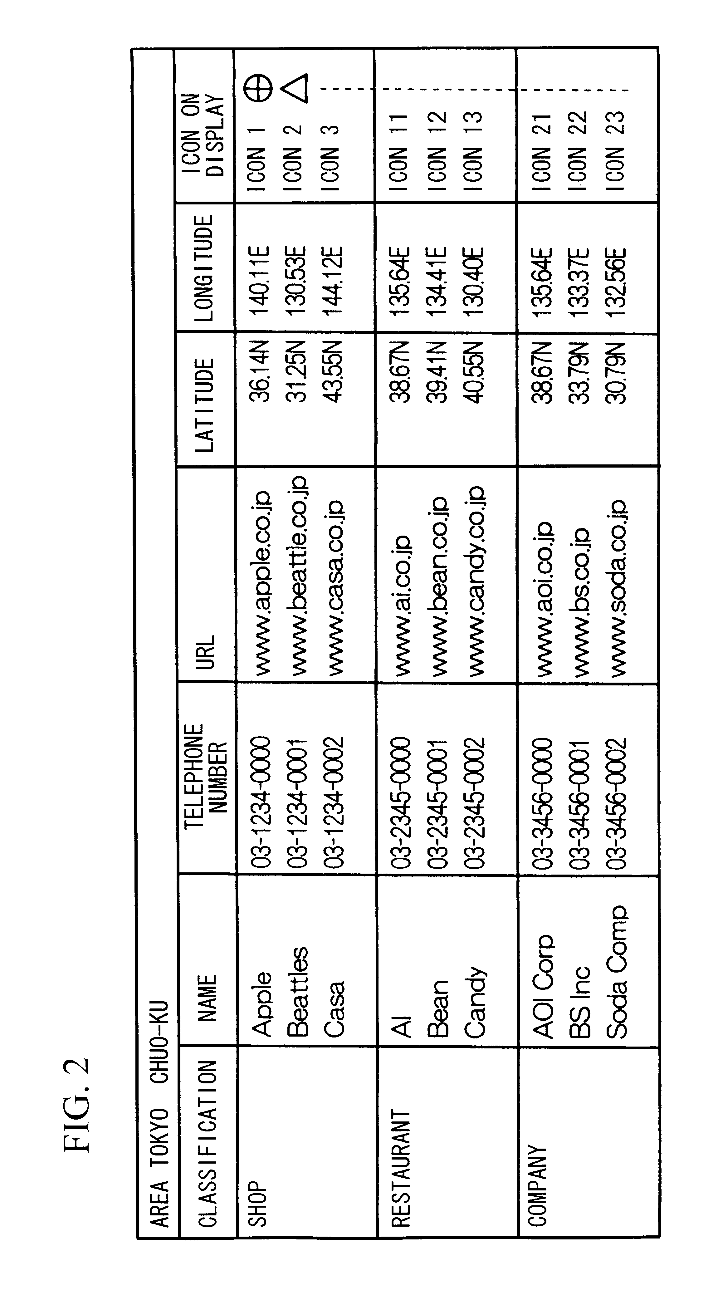
[0031]FIG. 16 shows an example of the content of the icon table that is set in the RAM of the cellular phone; and

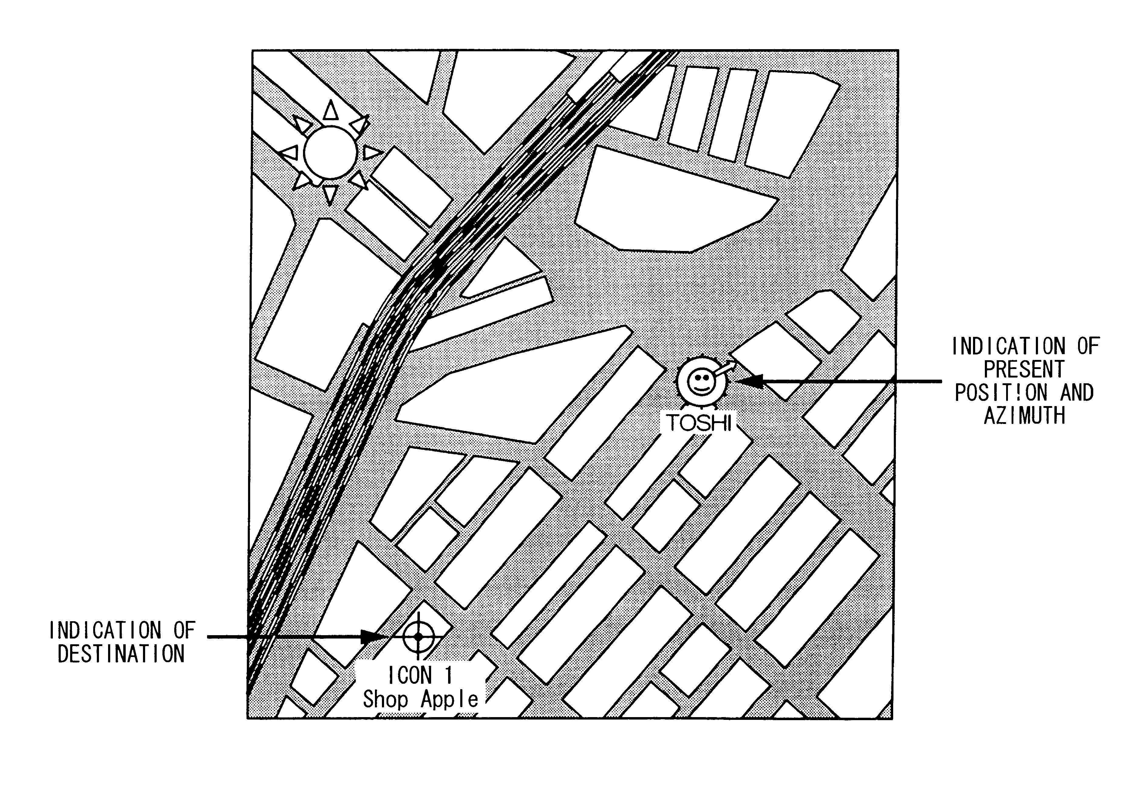
[0032]FIG. 17 shows an example of an image displayed on the screen such that icon symbols are each inclined and placed at different positions on the map.

DESCRIPTION OF THE PREFERRED EMBODIMENT

[0033]This invention will be described in further detail by way of examples with reference to the accompanying drawings.

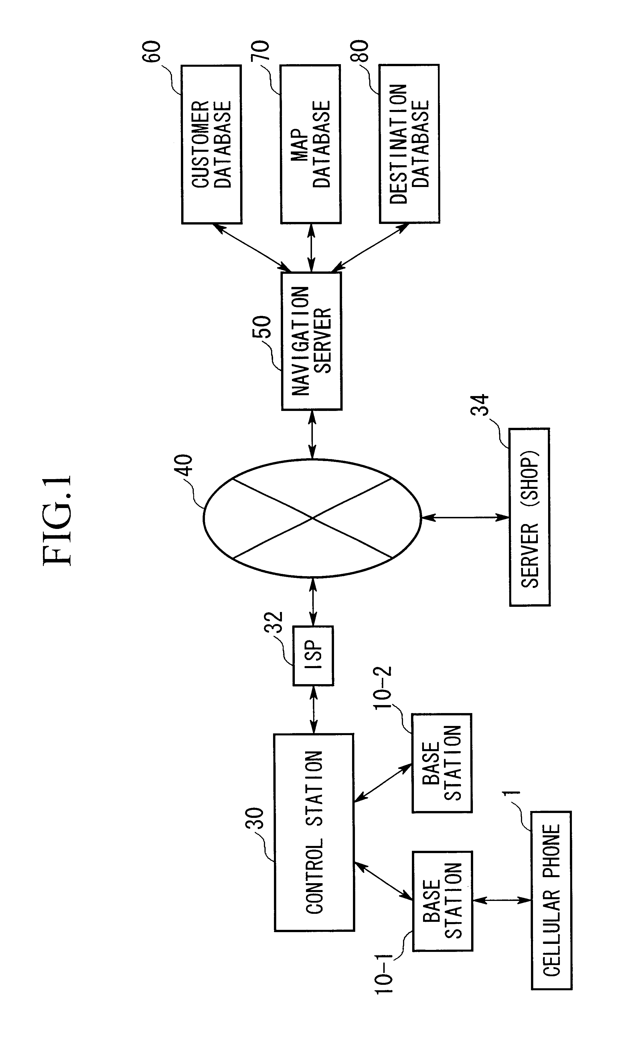
[0034]FIG. 1 shows the configuration of an overall navigation system in accordance with the preferred embodiment of the invention.

[0035]The navigation system shown in FIG. 1 employs a cellular phone (or portable telephone) ...


PUM


Abstract

A portable communication device comprises a GPS module for determining the present position, an electronic compass module for detecting an azimuth, a display, and a wireless communicator. Herein, the position information representing the destination and present position is transmitted towards the navigation server, which in turn provides the map information including the destination and present position, based on which corresponding icon symbols are indicated in the map displayed on the screen. In addition, the azimuth is also indicated by an angle departing from a north direction of the map information. Specifically, an azimuthal arrow symbol is displayed in proximity to the icon symbol representing the present position in the map, or the icon symbol is inclined by the aforementioned angle. Thus, it is possible to create images for navigation that are appropriately displayed on the screen and are recognizable in viewing without using expensive graphic processing.

Description

BACKGROUND OF THE INVENTION[0002]1. Field of the Invention[0003]This invention relates to portable navigation devices and systems, and online navigation services in wireless communication systems. Specifically, this invention relates to portable communication devices such as cellular phones having navigation functions, navigation servers for providing online navigation services, and navigation systems for providing online navigation services as requested by portable communication devices connected with networks in wireless communications.[0004]2. Description of the Related Art[0005]Conventionally, so-called map information services are known as a typical example of navigation services, which are provided online via networks. That is, when the user who has a prescribed contract for receiving a certain navigation service operates a portable communication device such as a cellular phone to designate an item of ‘map’ on the screen, the prescribed server or service station sends correspo...

Claims


Application Information

Patent Timeline
Patent Type & Authority Patents(United States)
IPC IPC(8): G01C21/34G01C21/36G01C21/00G01S19/48G08G1/005G08G1/137H04W28/00H04W64/00H04W88/02
CPCG01C21/36
Inventor MURAMATSU, TOSHIHIKO
Owner YAMAHA CORP
Why Eureka
Try Eureka