
Low cost multisensor high precision positioning and data integrated method and system thereof

a multi-sensor, high-precision technology, applied in the direction of position fixation, program control, navigation instruments, etc., can solve the problems of inertial navigation system cost, drift, high cost, etc., to solve cost problems, solve the effect of high accuracy elevation, azimuth, position and velocity, and low cos

Active Publication Date: 2005-04-12
AMERICAN GNC
View PDF13 Cites 46 Cited by
  • Summary
  • Abstract
  • Description
  • Claims
  • Application Information

AI Technical Summary

Benefits of technology

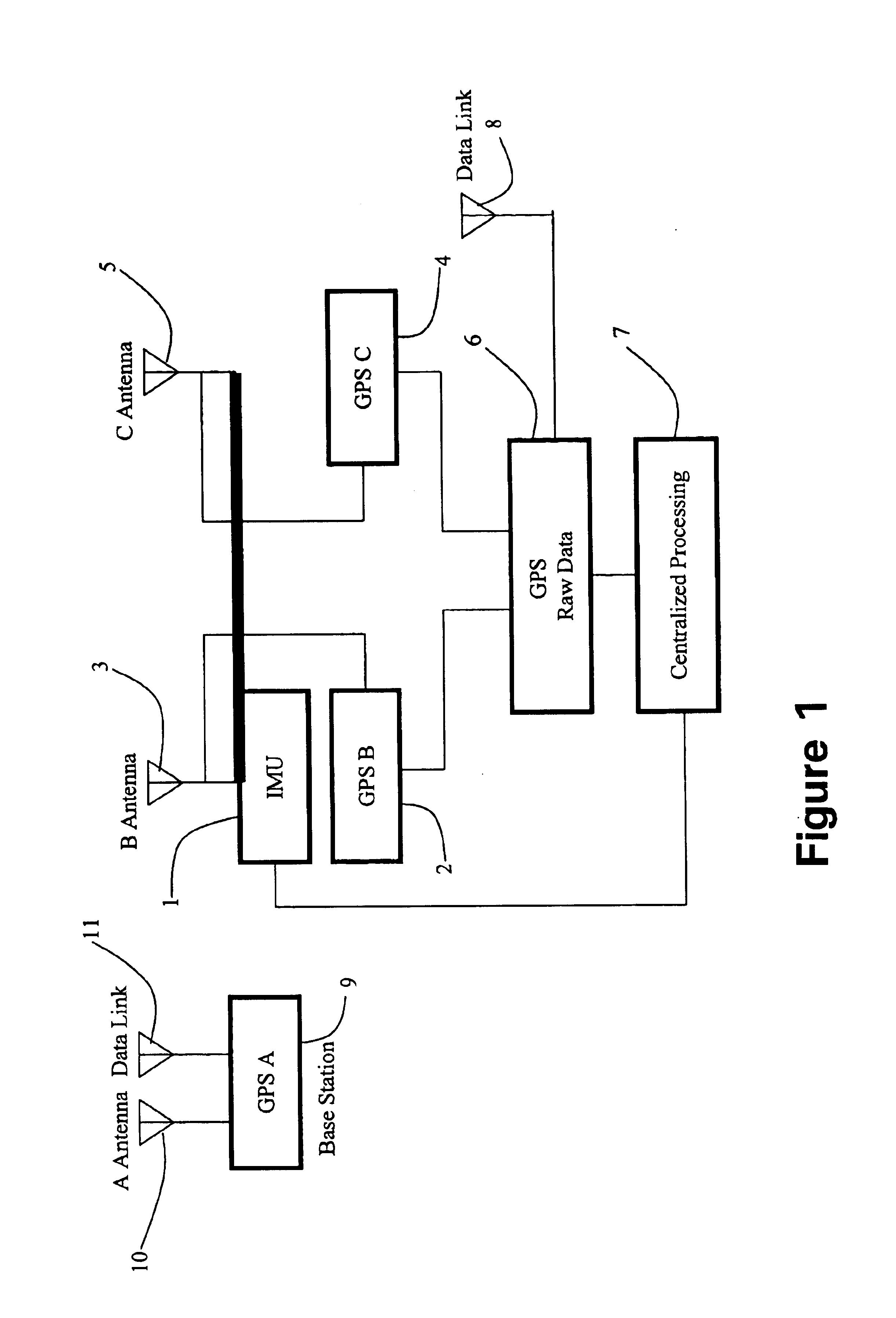
Another objective of the present invention is to provide a dual antenna GPS / IMU integrated method and system thereof, in which dual antenna GPS can provide high accuracy elevation, azimuth, position and velocity.
The present invention can substantially solve the cost problems encountered in avionics system integration by using state-of-the-art inertial sensor, integrated dual antenna global positioning system. The present invention is to balance multiple requirements imposed on the modern avionics systems design and manufacturing: low cost, high accuracy, reliability, small size and weight, low power consumption, ease of operation and maintenance, and ease of modification.

Problems solved by technology

Due to the high cost of high accuracy INS (inertial navigation system) and the errors accumulation, the applications of INS are restricted.
However, an inertial navigation system is expensive and subject to drift over an extended period of time.
This means that the position error increases with time.
This error propagation characteristic is primarily caused by its inertial sensor error sources, such as gyro drift, accelerometer bias, and scale factor errors.

Method used


Image

  • Low cost multisensor high precision positioning and data integrated method and system thereof
  • Low cost multisensor high precision positioning and data integrated method and system thereof
  • Low cost multisensor high precision positioning and data integrated method and system thereof

Examples


Embodiment Construction

Generally, the accuracy of inertial navigation systems (INS) can be improved by employing highly accurate inertial sensors or by compensating with data from an external sensor. The cost of developing and manufacturing inertial sensors increases as the level of accuracy improves. The advances in new inertial sensor technology and electronic technologies have led to the availability of low cost inertial sensors, such as mechanical-electronic-micro-system (MEMS) inertial sensors. Mechanical-electronic-micro-system inertial sensors borrow processes from the semiconductor industry to fabricate tiny sensors and actuators on silicon chips. The precision of these new inertial sensors may be less than what conventional sensors achieve, but they have enormous cost, size, weight, thermal stability and wide dynamic range advantages over conventional inertial sensors.

The present invention employs an integrated global positioning system (GPS) / inertial measurement unit using three GPS carrier phas...


PUM


Abstract

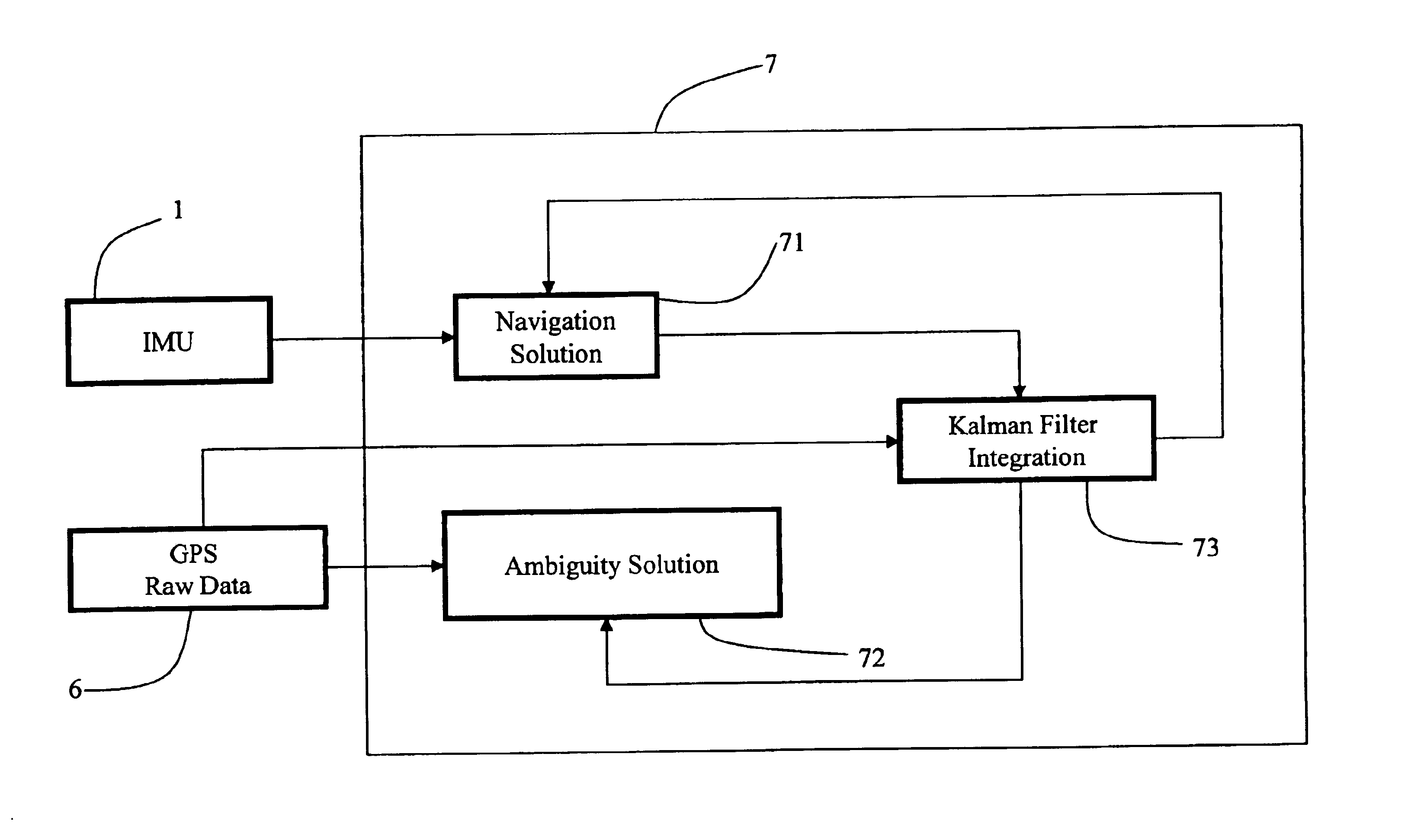
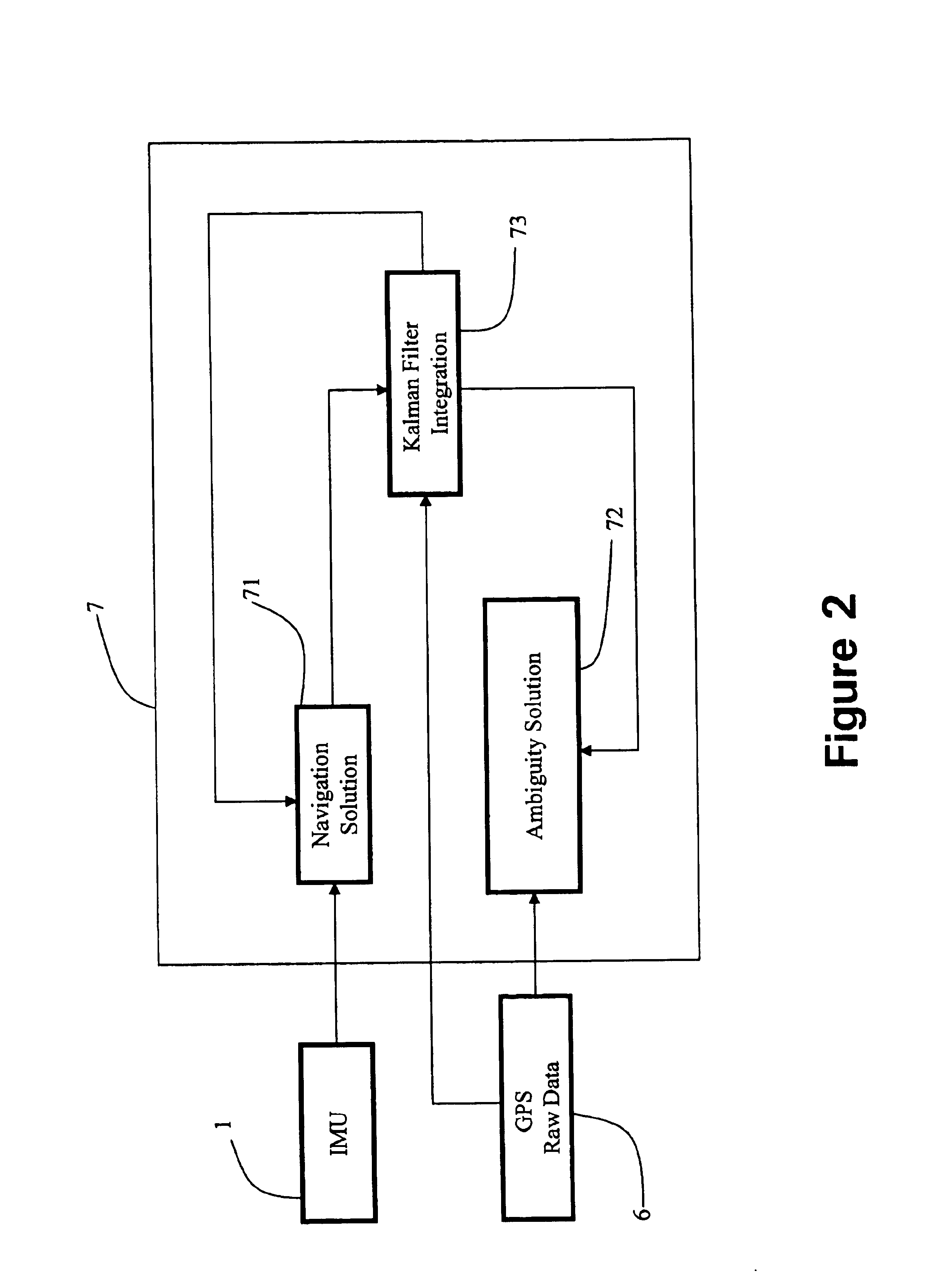
The design of the low cost GPS / IMU positioning and data integrating method, which employs integrated global positioning system / inertial measurement unit enhanced with dual antenna GPS carrier phase measurements to initialize and stabilize the azimuth of the low cost GPS / IMU integrated system, is performed. The utilization of the raw carrier phase measurement for the integration speeds up the ambiguity search.

Description

BACKGROUND OF THE PRESENT INVENTIONTECHNICAL FIELD1. Field of InventionThe present invention relates generally to the design of dual antenna GPS / INS integrated systems, and more particularly to the low cost GPS / IMU positioning and data integrating method, which employs integrated global positioning system / inertial measurement unit enhanced with dual antenna GPS carrier phase measurements to initialize and stabilize the azimuth of the low cost GPS / IMU integrated system. The utilization of the raw carrier phase measurements for the integration speeds up the ambiguity search.2. Description of Related ArtsDue to the high cost of high accuracy INS (inertial navigation system) and the errors accumulation, the applications of INS are restricted. GPS can provide position, velocity, pseudorange, carrier phase and ephemeris without errors accumulation. It has been found that GPS / INS integration is superior to each one working alone.Advancement in the technology of the low cost solid-state ine...

Claims


Application Information

Patent Timeline
Patent Type & Authority Patents(United States)
IPC IPC(8): G01C21/34G01C21/28G01C21/36G01C21/26G01S1/00G01C21/16G01S5/14G01S19/44G01S19/49G01S19/52G01S19/55
CPCG01C21/165G01S19/44G01S19/55G01S19/49G01S19/52G01C21/188
Inventor HU, GUOHUILIN, CHING-FANG
Owner AMERICAN GNC
Learn More