
Navigator

Inactive Publication Date: 2006-05-30
SANYO ELECTRIC CO LTD +1
View PDF19 Cites 9 Cited by
  • Summary
  • Abstract
  • Description
  • Claims
  • Application Information

AI Technical Summary

Benefits of technology

[0010]An object of the present invention is to provide a navigator that receives a minimum of information needed and that thus, by reducing the amount of information received, saves the charge for communication. Another object of the present invention is to provide a navigator that prevents interruption of information by receiving map information and locality information before communication becomes impossible. Still another object of the present invention is to provide a navigator that, by receiving only needed information without increasing the storage capacity, reduces the likeliness of map information being interrupted in an area where communication is impossible.

Problems solved by technology

However, even though information can be acquired through communication in a manner as described above, the navigator has only a small storage capacity, and therefore receiving large-scale, detailed map information and locality information all the time increases the frequency of reception, resulting in a high charge for communication.
Moreover, receiving both map information and locality information increases the amount of information, increasing the frequency of reception and thus the charge for communication.
Thus, the map information of already traveled locations and such map information as is highly unlikely to be used is also kept acquired unnecessarily.
This method, therefore, is too inefficient to be applied to a navigator having a limited storage capacity.
Specifically, when the navigator happens to be traveling an area where communication is impossible, the map information being received is highly likely to be interrupted.

Method used


Image

  • Navigator
  • Navigator
  • Navigator

Examples


first embodiment

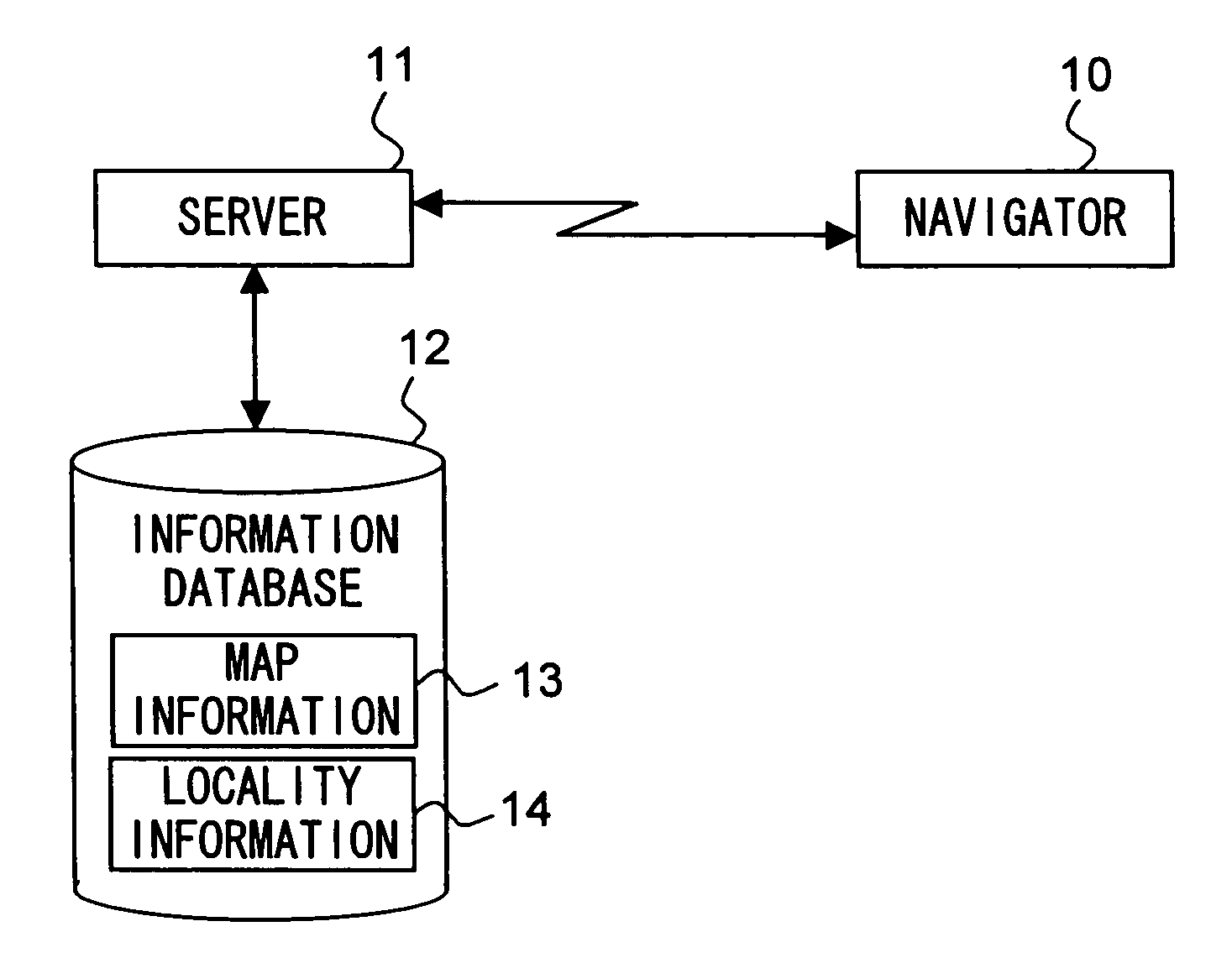
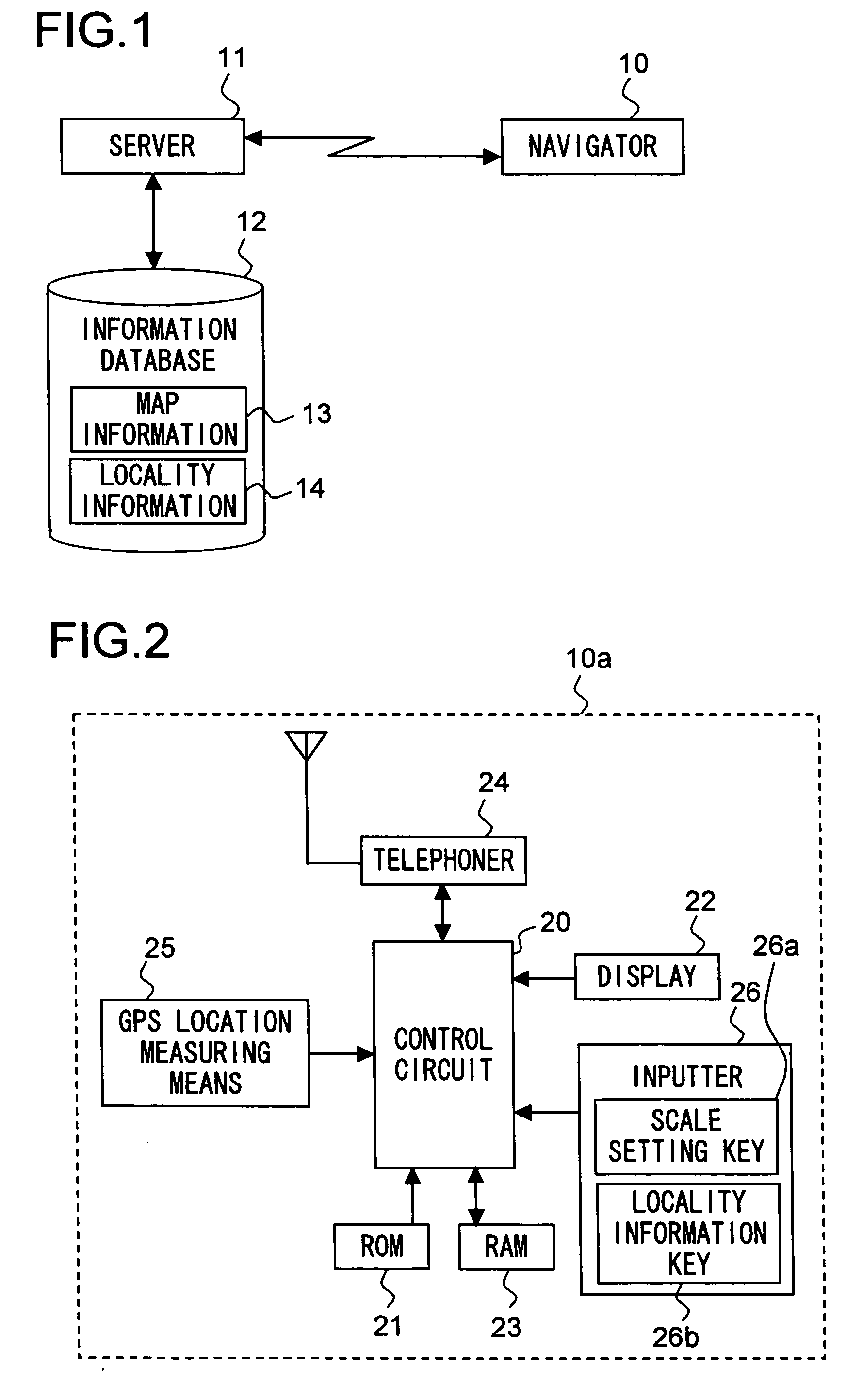
[0055]FIG. 1 is a diagram showing the configuration of a communications system employing a navigator according to the present invention. When the navigator 10 requests map information 13 or locality information 14 from a server 11, the server 11 reads out appropriate map information 13 or locality information 14 from an information database 12 according to the conditions requested by the navigator 10, and then delivers the retrieved information to the navigator 10. Here, the map information 13 is composed of a plurality of sets of map information on different scales, and the locality information 14 is so composed as to correspond to the map information 13 on those different scales.

[0056]The navigator 10 and the server 11 may communicate with each other by any means of communication so long as they can communicate with each other. For example, in a case where information is delivered over the Internet, it is possible to use a telephone network such as a mobile or cellular telephone n...

embodiment 1

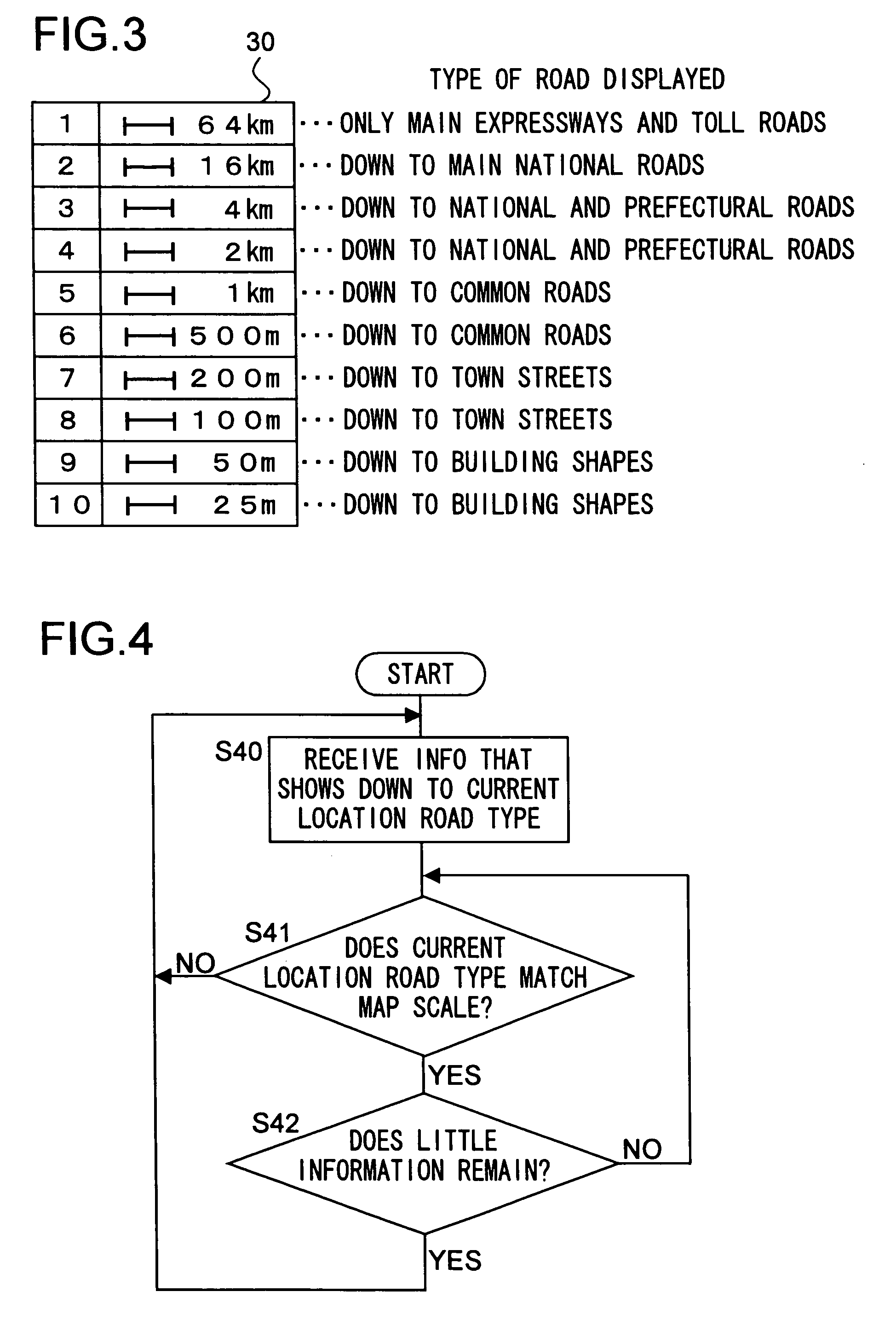
[0069]Example 1 deals with a case where the navigator 10a is used with no destination set. FIG. 4 is a flow chart showing the operation of the navigator 10a. First, in step S40, map information or locality information on such a scale as to show the type of road passing at the current location is received and stored in the RAM 23, and then the map information or locality information is read out from the RAM 23 and displayed on the display 22 with the current location superimposed thereon. Suppose now that the current location is on a town street. Then, the control circuit 20 selects, for example, the scale of 100 m from the scale table 30 shown in FIG. 3, then receives map information or locality information on that scale, and then displays an image 50 as shown in FIG. 5. In the figure, the arrow indicates the current location.

[0070]The flow then proceeds from step S40 to step S41, where whether or not the type of road passing at the current location matches the scale of the map bein...

example 2

[0073]Example 2 deals with a navigator 10a that is just like that of Example 1 but that additionally increases the scale of the displayed map whenever a branch point is approached. FIG. 7 is a flow chart showing the operation of the navigator 10a. First, in step S70, as in step S40 in Example 1, map information or locality information is displayed. Suppose now that the current location is on a national road. The, the control circuit 20 selects, for example, the scale of 2 km from the scale table 30 shown in FIG. 3, then receives map information or locality information on that scale, and then displays an image 80 as shown in FIG. 8.

[0074]The flow then proceeds from step S70 to S71, where whether or not there is a branch point within a predetermined area (for example, within 2 km) ahead of the current location is checked. If, in step S71, there is no branch point within the predetermined area ahead, then the flow proceeds to step 25, where, as in step S41 in Example 1, whether or not ...


PUM


Abstract

A navigator receives, through communication with a server, only such map information or locality information as is considered to be necessary, and stores it by overriding with it already used map information and locality information. Thus, the navigator, despite having a small storage capacity, is free from interruption of display. Receiving minimum needed information helps save the communication charge.

Description

CROSS-REFERENCE TO RELATED APPLICATION[0001]This application is a National Stage entry of International Application No. PCT / JP02 / 01986 filed Mar. 4, 2002.TECHNICAL FIELD[0002]The present invention relates to a navigator that receives map information and locality information through communication.BACKGROUND ART[0003]Known as conventional navigators are apparatuses that are so configured as to acquire the information of the current location by the use of a current location detecting means, such as a GPS (global positioning system) receiver, then read out map information stored in a storage means, such as a CD-ROM, and then display a map around the current location on a displaying means, such as a monitor, and indicate the current location by the use of a guiding means, such as by displaying it or telling it with voice.[0004]Some navigators can receive the latest, detailed map information and locality information through communication achieved by means of FM multiplex broadcast, known ...

Claims


Application Information

Patent Timeline
IPC IPC(8): G01C21/34G01C21/26G01C21/32G08G1/0962
CPCG01C21/32G08G1/0962G01C21/367G01C21/3896G08G1/0969
Inventor KODANI, KIYOSHITANAKA, HIROSHISUGAI, TAKASHIUMEZAWA, ISAOKADONO, HIDENORIABE, YUICHINAKASHIMA, KAZUHIROTAKUNO, SHINJITAGUCHI, TSUTOMU
Owner SANYO ELECTRIC CO LTD
Learn More