Navigation system and navigation equipment

a navigation system and navigation equipment technology, applied in navigation instruments, maps/plans/charts, maps, etc., can solve the problems of user burdened with increased transmission costs, insufficient navigational guidance information provided in dvds or the like, etc., to reduce communication time and reduce communication costs

Inactive Publication Date: 2006-07-04
PIONEER CORP
View PDF9 Cites 36 Cited by
  • Summary
  • Abstract
  • Description
  • Claims
  • Application Information

AI Technical Summary

Benefits of technology

[0022]Route information having a small amount of data and formed of only road information relating to a road constituting the optimal route is transmitted by radio as described above to reduce the time required for communication, thereby providing high-speed navigational guidance and reduced communication costs.

Problems solved by technology

However, the latest information provided in a DVD or the like is insufficient for dynamic navigational guidance.
However, as described above, the distribution of map information over a communication network such as the Internet would require the transmission of a large quantity of map data and road data to the user's navigation equipment.
This has raised problems that a long transmission time is required, there by making it difficult to provide fast response sufficient for dynamic navigational guidance, and the user is burdened with an increase in costs for transmissions.

Method used


Image

  • Navigation system and navigation equipment
  • Navigation system and navigation equipment
  • Navigation system and navigation equipment

Examples


Embodiment Construction

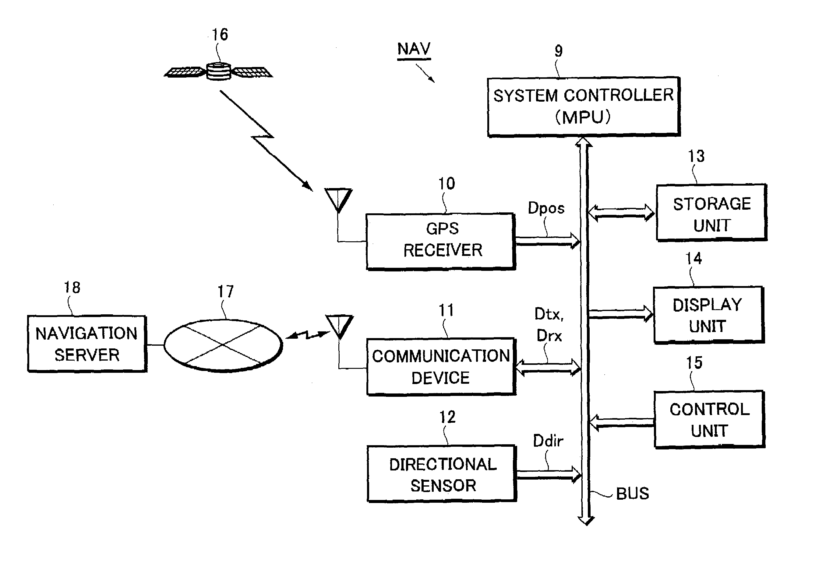
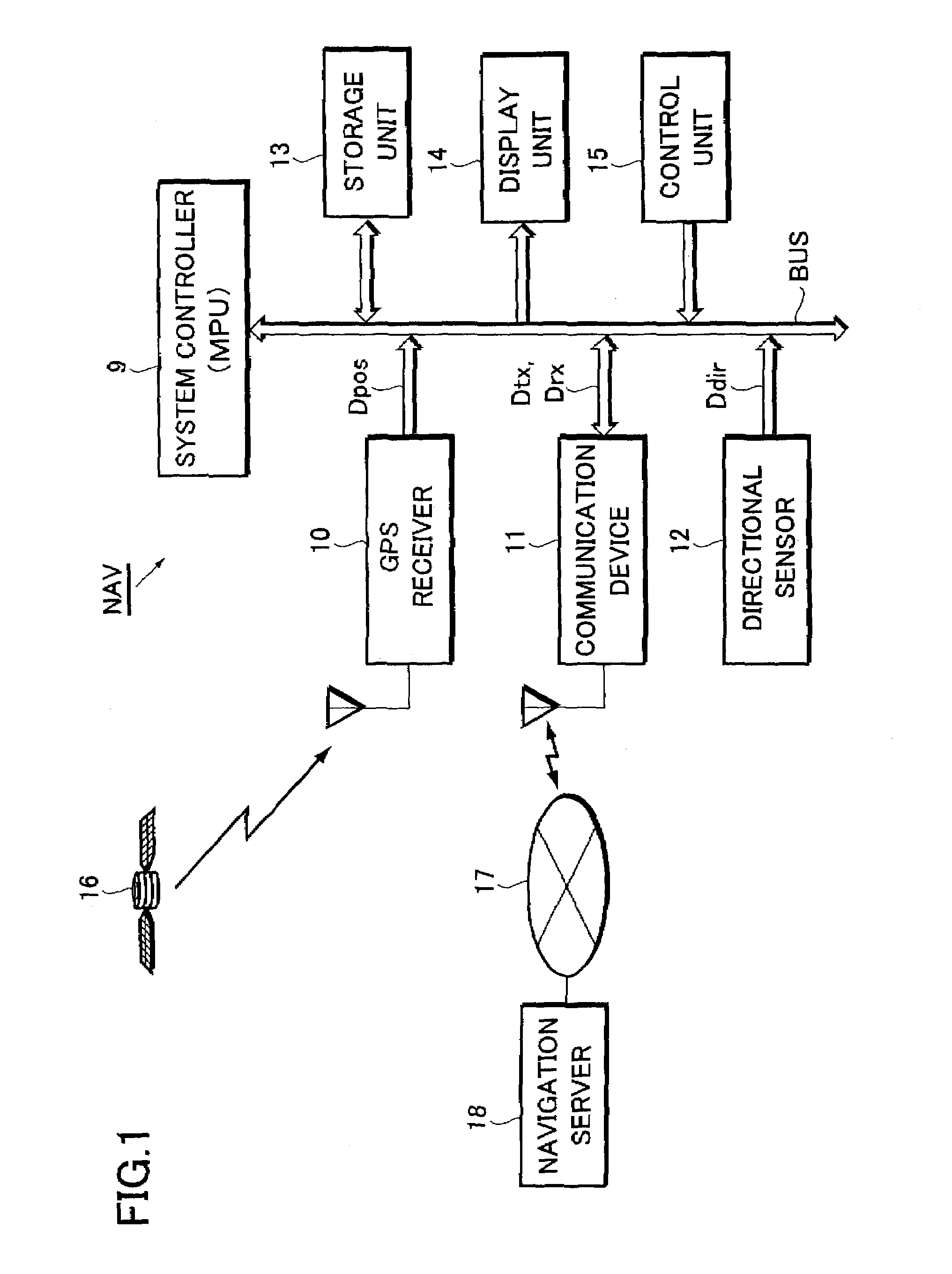
[0032]Now, the present invention will be described below in more detail with reference to the accompanying drawings in accordance with the embodiment. FIG. 1 is a block diagram illustrating the configuration of vehicle navigation equipment and a navigation system according to one preferred embodiment of the present invention.

[0033]For descriptive purposes, it is to be understood that a location currently determined by a GPS receiver 10, discussed later, is referred to as a “self-location” while a current location estimated by map matching is referred to as a “current position.”

[0034]Referring to FIG. 1, a mobile unit or the navigation equipment NAV has a system controller 9 having a microprocessor (MPU) to serve as control means, the GPS receiver 10, a communication device 11, a directional sensor 12, a storage unit 13, a display unit 14, and a control unit 15, all of which are centrally controlled by the system controller 9.

[0035]In other words, the GPS receiver 10, the communicati...


PUM


Abstract

A navigation system and navigation equipment which reduce the time required for radio transmissions to implement fast navigational guidance. The navigation equipment communicates bi-directionally by radio with a navigation server, thereby providing navigational guidance. The navigation equipment transmits position data delivered by a GPS receiver to the navigation server through a communication device and acquires, from the communication device, map data for display indicative of a map of a surrounding area including a self-location provided by the position data sent back from the navigation server. The navigation equipment then performs map matching between road information contained in the acquired map data for display and the position information, thereby determining a current position on the road, thereby displaying a map in the form of an image on a display unit in accordance with the map data for display and displaying the current position determined by the map matching on the map displayed in the form of an image.

Description

BACKGROUND OF THE INVENTION[0001]The present invention relates to a navigation system and navigation equipment which present the location of a mobile unit or the like using map information which is provided over a communication network such as the Internet.[0002]The present application claims priority from Japanese Application No. 2002-126940, the disclosure of which is incorporated herein by reference.[0003]For example, in the field of the navigation technology for presenting the location of a mobile unit or the like, a conventional vehicle navigation equipment configured as shown in FIG. 6 has been used to provide the location of a traveling vehicle to a driver or a passenger in a vehicle.[0004]That is, the conventional navigation equipment includes an information read unit 3 for reading information from a large capacity information storage medium such as a CD (Compact Disc) or a DVD (Digital Versatile Disc) on which stored are map data 1 to be displayed and road data 2 containing...

Claims


Application Information

Patent Timeline
Patent Type & Authority Patents(United States)
IPC IPC(8): G08G1/123G09B29/00G01C21/00G01C21/34G08G1/0968G08G1/137G09B29/10
CPCG01C21/34G08G1/096816G08G1/096811
Inventor HASHIDA, MASAYAMATSUKAWA, TOSHIKINAGANUMA, MAYUMI
Owner PIONEER CORP
Why Eureka
Try Eureka