Traffic data management and simulation system

Active Publication Date: 2006-12-26
CALIPER CORPORATION
View PDF9 Cites 80 Cited by
  • Summary
  • Abstract
  • Description
  • Claims
  • Application Information

AI Technical Summary

Benefits of technology

[0017]The systems and methods of the invention provide, inter alia, systems that are designed to allow for geographical analyses of traffic flowing over a wide scale road network. Accordingly, the systems described herein integrate geographical information systems (GIS) directly with traffic simulation processes to allow a user to analyze traffic patterns and loads at specific geographic locations of regions. Thus it allows the user to import and utilize existing data on travel demand, road network, and survey data from a wide range of sources. Additionally, the systems include multiple traffic simulation models for simulating traffic across different segments of the traffic network. The different models provide varying levels of granularity for modeling vehicle movements over the traffic network. In other words, different parts of the road network can be designated to use a particular type of traffic simulation model. Thus portions of the traffic network that are to be analyzed more closely can use the traffic simulator model with the highest degree of granularity, while traffic patterns acros

Problems solved by technology

Because of the many complex aspects of a traffic system, including driver behavioral considerations, vehicular flow interactions within the network, stochasticity caused by weather effects, traffic accidents, seasonal variation, etc., it has been notoriously difficult to estimate traffic flows over a road network.
Although these traffic simulation tools are helpful, they are not easy to use and require a labor intensive process for the preparation of data input and interpretation and analysis of simulation output.
Moreover, the size of the road networks existing simulators can handle, or the level of details these simulators can provide are often limited.
A further drawback to these existing systems is that these models lack accurate geographical representation of network objects.
As a result of the arbitrarily chosen coordination systems, it is often difficult to accurately geocode the survey data, and reference data from different sources.
Furthermore, the lack of geographically accurate

Method used


Image

  • Traffic data management and simulation system
  • Traffic data management and simulation system
  • Traffic data management and simulation system

Examples


Example

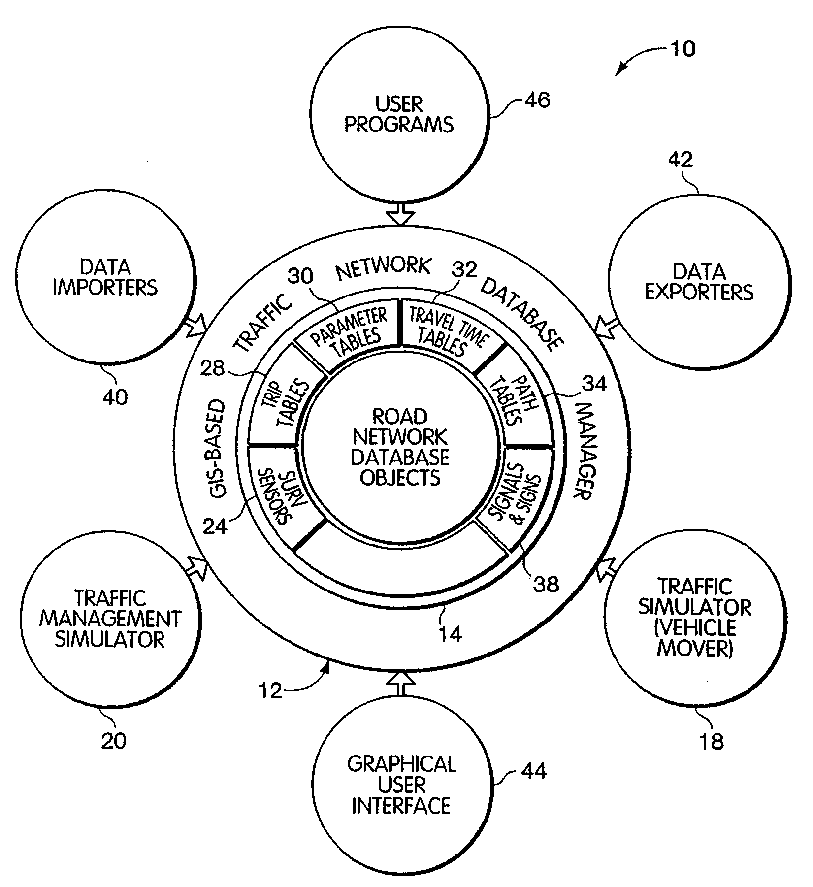
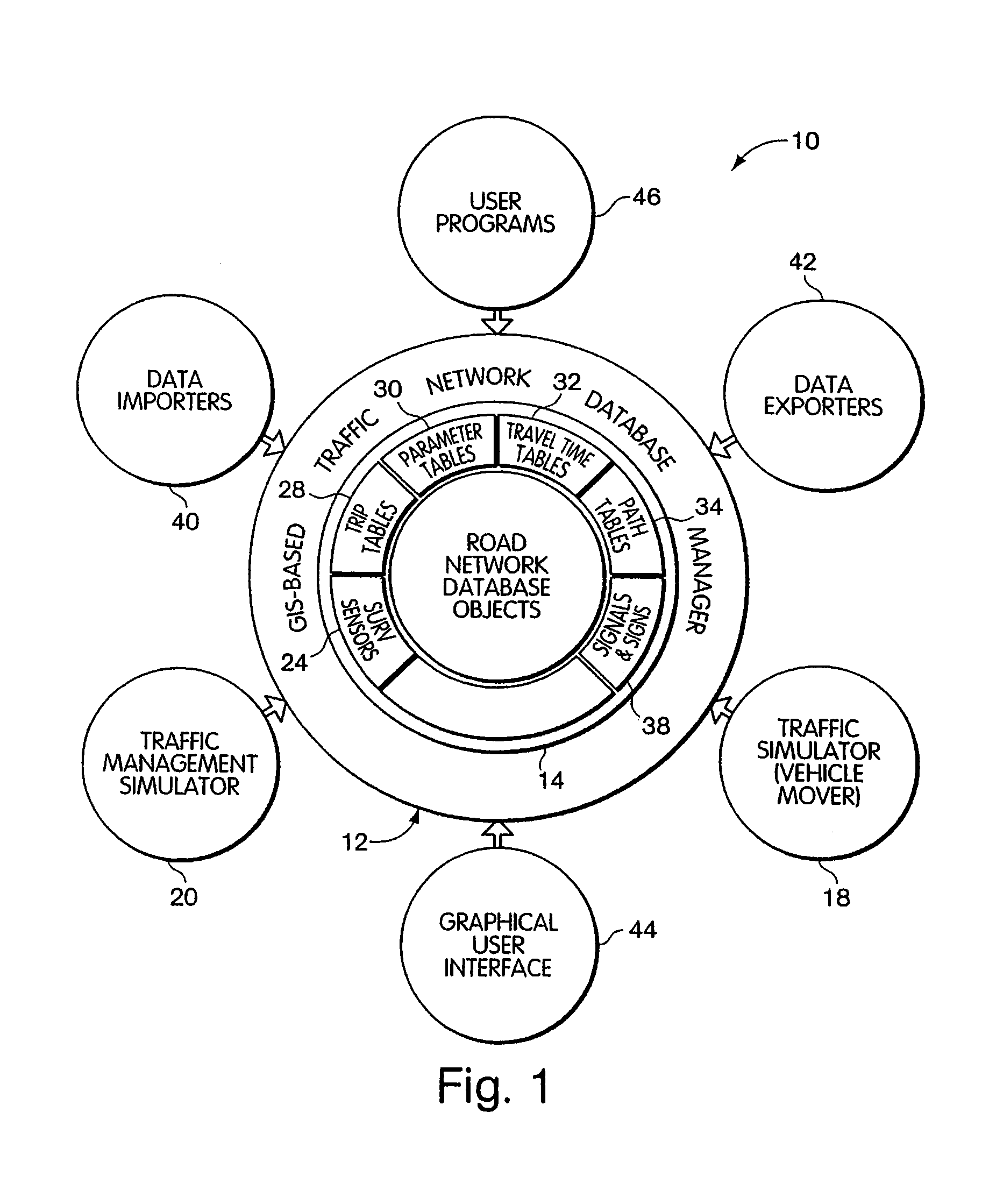
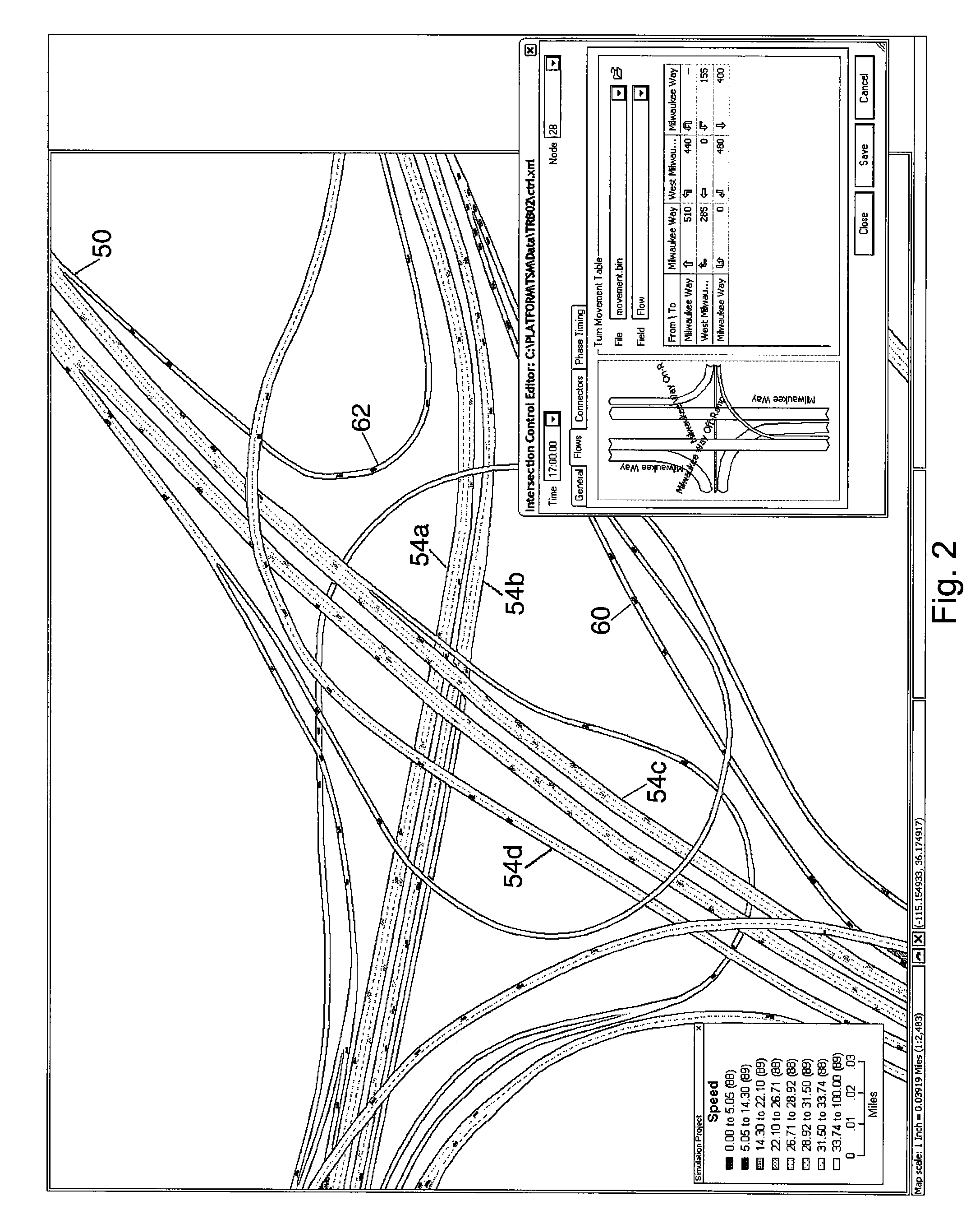
[0026]To provide an overall understanding of the invention, certain illustrative embodiments will now be described, including a traffic simulation system having the ability to simulate large, heterogeneous traffic networks, while at the same time providing detailed output for selected portions of the traffic network. However, it will be understood that the systems and methods are not limited to these particular embodiments and can be adapted and modified for other suitable applications and to provide other types of products and that such other additions and modifications will not depart from the scope hereof.

[0027]The systems and methods of the invention provide, among other things, systems that allow for large scale traffic simulation and analysis over a large road network. Additionally, as will be described herein, the systems and methods may provide for a geographical information system (GIS) that cooperates with real world traffic surveillance and control systems to provide dyna...


PUM


Abstract

Systems and methods for, inter alia, geographically based analyses of traffic being carried over a wide scale traffic network. The systems integrate geographical information systems (GIS) with traffic simulation processes to allow a user to analyze traffic patterns and loads at specific geographic locations of regions. Additionally, these systems allow for traffic analysis over a wide scale traffic network that may encompass the traffic network that exists within an geographic region and can include, as examples, the traffic networks that span across a city, that interconnect cities, that interconnect states and that run across multiple states. To this end, the systems include traffic simulators that can adaptively or controllably select between multiple traffic simulation models for simulating traffic across different segments of the traffic network. The different models provide varying levels of granularity for measurements of geographical location of a vehicle traveling over the traffic network.

Description

CROSS REFERENCE TO RELATED APPLICATIONS[0001]This claims the benefit of U.S. Provisional Patent Application No. 60 / 300,197, filed Jun. 22, 2001, entitled TRAFFIC DATA MANAGEMENT, ANALYSIS, AND SIMULATION and naming Howard Slavin and Qi Yang as inventors, the contents of which are hereby incorporated by reference.FIELD OF THE INVENTION[0002]The system and methods described herein relate to traffic analysis and data management systems and modeling methods, and more specifically, to systems and methods that integrate geographic information systems and traffic simulation.BACKGROUND OF THE INVENTION[0003]Traffic simulation is a useful tool for analyzing traffic flows when designing roads, highways, tunnels, bridges, and other vehicular traffic ways. It can help to answer many “what-if” questions prior to field construction; compare and determine the trade-offs between scenarios such as different network configurations, suitable placements for signs, optimal timing of traffic signals, and...

Claims


Application Information

Patent Timeline
IPC IPC(8): G06G7/48G08G1/01
CPCG06F17/5009G08G1/0112Y10S707/99945Y10S707/99948G08G1/0129G06F30/20
Inventor YANG, QISLAVIN, HOWARDSTEFANSSON, KJARTANRABINOWICZ, ANDRESOLSBERG, SIMONLACLAIR, MARYBRANDON, JONATHAN
Owner CALIPER CORPORATION
Why Eureka
Try Eureka