Digitally watermarked maps and signs and related navigational tools

a digital watermark and map technology, applied in the field of navigation and map orientation, can solve the problems of inability to traverse, struggle to accurately, and difficulty in map navigation, and achieve the effects of improving navigation, enhancing education, and easy road travel

Inactive Publication Date: 2007-07-24
DIGIMARC CORP
View PDF147 Cites 34 Cited by
  • Summary
  • Abstract
  • Description
  • Claims
  • Application Information

AI Technical Summary

Benefits of technology

[0007]Global positioning systems (GPS) have improved navigation by providing accurate location feedback. As will be appreciated by those skilled in the art, military and civilian water, ground, and airborne vehicles often use GPS systems for navigation. GPS is a satellite-based radio navigation system capable of providing continuous position, velocity, and time information. GPS receiver units receive positioning signals from a constellation of satellites deployed in various orbits about earth (e.g., 12-hour orbits). The satellites continuously emit electronic GPS signals (or telemetry) for reception by ground, airborne, or watercraft receiver units. By receiving GPS signals from a plurality of satellites, a properly configured receiver unit can accurately determine its position in three dimensions (e.g., longitude, latitude, and altitude).
[0020]Such watermarking techniques, and many others known to those skilled in the art, may be suitably employed to improve navigation, easy road journeys and enhance education, among other benefits.

Problems solved by technology
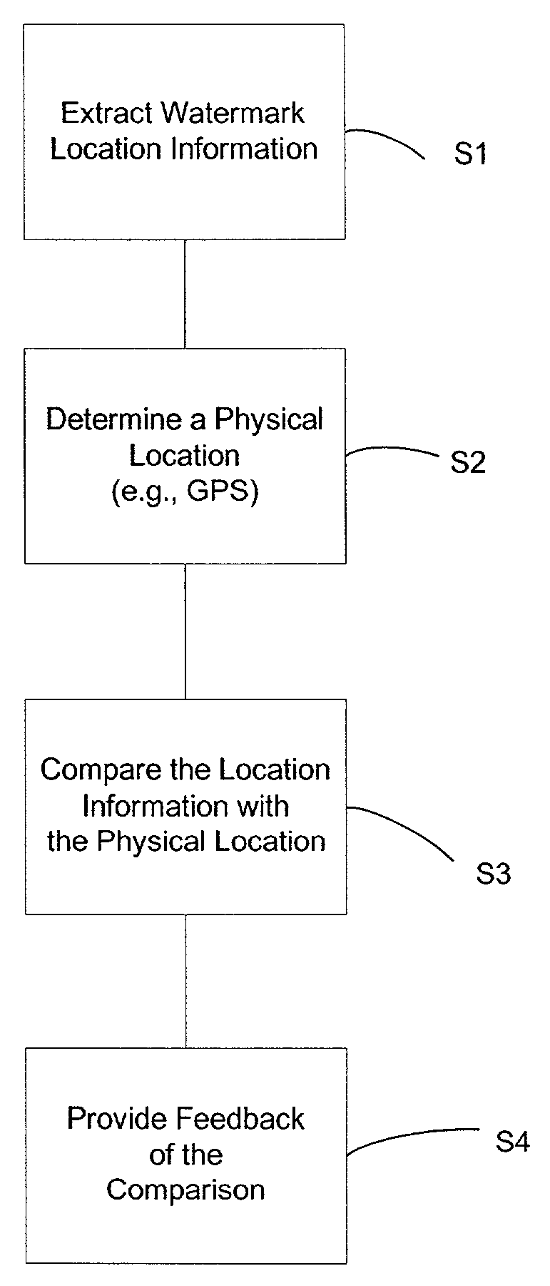
Map navigation becomes even more difficult for those who retreat into the wilderness, some becoming lost, unable to traverse the unfamiliar terrain with a map.
Many young geography students, when presented with a world or area map, struggle to accurately place themselves within a map to determine their relationship to various area or world locations.
One problem that arises in many watermarking applications is that of object or positioning corruption.
If the object is reproduced, skewed, or distorted, in some manner such that the content presented for watermark decoding is not identical to the object as originally watermarked, then the decoding process may be unable to recognize and decode the watermark.

Method used


Image

  • Digitally watermarked maps and signs and related navigational tools
  • Digitally watermarked maps and signs and related navigational tools
  • Digitally watermarked maps and signs and related navigational tools

Examples


Embodiment Construction

Watermark Embedding

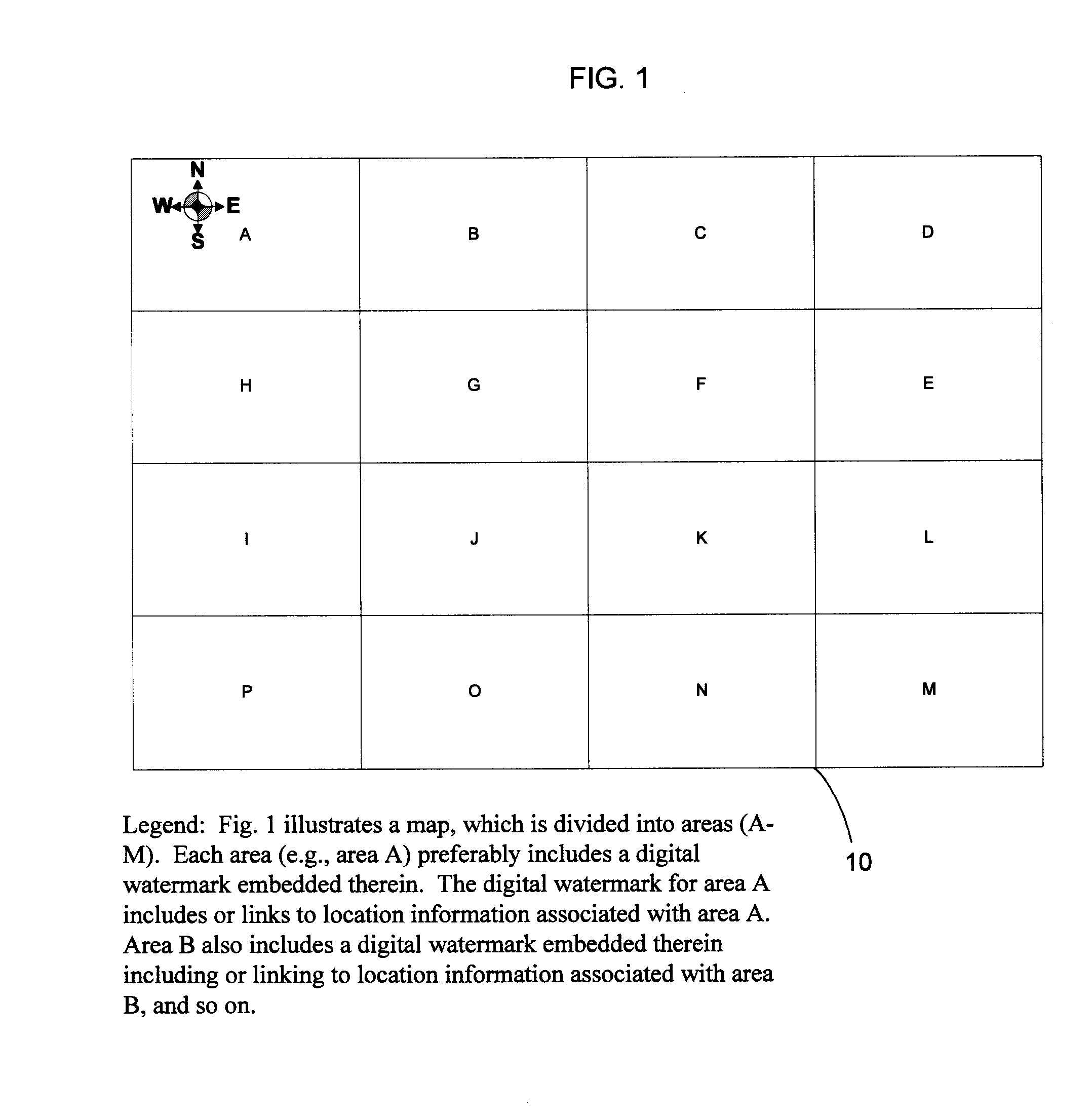
[0026]In accordance with a first embodiment of the present invention, a map 10 includes plural-bit data steganographically encoded therein. (The term map is used broadly herein and includes, for example, navigational tools and documents, road maps, atlases, wilderness maps, area maps, city maps, tourist maps, location guides, walk or run routes, path-layouts, 3-demensional models, vegetation maps, building maps, structure maps, stadium seating and concert hall locations, park maps, amusement or theme park maps, DEM maps, master maps, topographical maps, globes, relief maps, to name just a few. A map may also include a digitized map for display on a monitor, TV, LCD, etc.). Map 10 can be printed or drawn on any suitable surface including paper, fibers, fabric, wood, plastic, metal, metal-alloys, objects, plaster, laminates, etc., etc. A digitized map image may include plural-bit data steganographically encoded therein.

[0027]The encoding of the map can encompass art...


PUM


Abstract

Maps and signs are embedded with plural-bit data in the form of digital watermarks. In one embodiment, the plural-bit data includes location information with respect to a map. A handheld reading device extracts the location information from the map. The reading device then compares the location information with a physical location of the device. Feedback is provided to help a device user to correlate the map location with the physical location. In another embodiment, signs are watermarked to provide navigational and informational aids. The watermarks may include unique identifiers, which allow database lookup of related information.

Description

FIELD OF THE INVENTION[0001]The present invention relates to navigation and map orientation, and is particularly illustrated with reference to maps and signs embedded with digital watermarks.BACKGROUND AND SUMMARY OF THE INVENTION[0002]A map is both a beloved and bewildering companion to those who choose to navigate an unfamiliar city or traverse across country to find a blissful vacation spot. Map navigation becomes even more difficult for those who retreat into the wilderness, some becoming lost, unable to traverse the unfamiliar terrain with a map.[0003]Countless children, stuffed into the backseats of vacation-bound station wagons, sport utility vehicles and Volkswagen bugs, have pleaded to know if “we are there yet.” Befuddled parents search for convincing answers as they unfold yet another map.[0004]In some circles, orienteering and adventure racing rise to the level of competition, drawing crowds of participants and network audiences. Such competitions force participants to n...

Claims


Application Information

Patent Timeline
Patent Type & Authority Patents(United States)
IPC IPC(8): H04L9/00G06F7/00H04K1/00G06F21/00G06T1/00G09B29/10H04L15/34
CPCG06F21/6209G06T1/0042G06T1/0071G09B29/106H04N1/32144G06F2221/0737G06F2221/2113G06T2201/0051G06T2201/0052G06T2201/0061H04N2201/3233Y10S707/99945Y10S707/99948G06F21/16
Inventor BRUNDAGE, TRENT J.LOFGREN, NEIL
Owner DIGIMARC CORP
Why Eureka
Try Eureka