Global navigation satellite system landing systems and methods

a global navigation satellite and landing system technology, applied in the field of aircraft, can solve the problems of unable unable to define a gbas architecture to support approach and landing operations in category ii/iii conditions, and unable to achieve the definition of a gbas architecture to support approach and landing operations in the category ii/iii conditions

Inactive Publication Date: 2008-05-13
THE BOEING CO
View PDF11 Cites 28 Cited by
  • Summary
  • Abstract
  • Description
  • Claims
  • Application Information

AI Technical Summary

Problems solved by technology

At this time if he decides there are inadequate visual cues to safely land the aircraft, he aborts the landing attempt.
However, the currently defined GBAS architecture does not support approach and landing operations in Category II / III (CAT II / III) conditions.
Definition of a GBAS architecture to support approach and landing operations in Category II / III conditions has been difficult.
This is because the current GPS satellite constellation alone does not provide with high availability a sufficiently robust geometry between the satellites and user needed to provide the sufficient accuracy and integrity performance to support this type of operation.
However, pseudolites can interfere with the normal reception of GPS signals.
Also, pseudolites are potentially expensive and, at a minimum, entail increased ground infrastructure costs.
GPS / INS integration is also relatively expensive.
Also, this solution is still ultimately limited by the coverage offered by the GPS satellite constellation.

Method used


Image

  • Global navigation satellite system landing systems and methods
  • Global navigation satellite system landing systems and methods
  • Global navigation satellite system landing systems and methods

Examples


Embodiment Construction

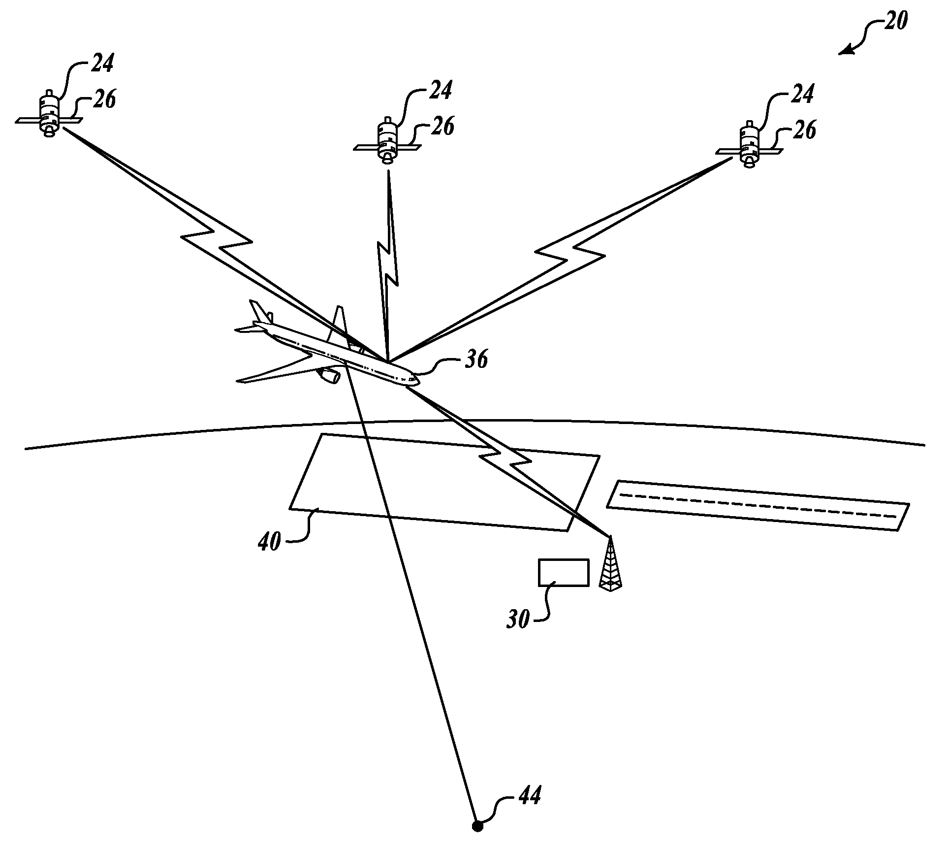
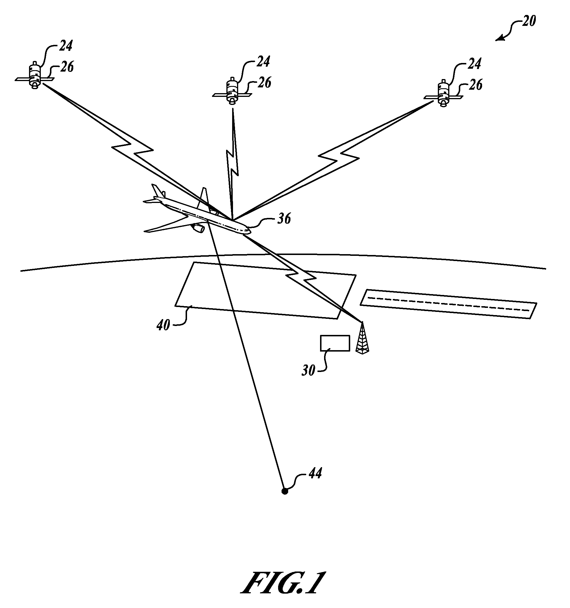
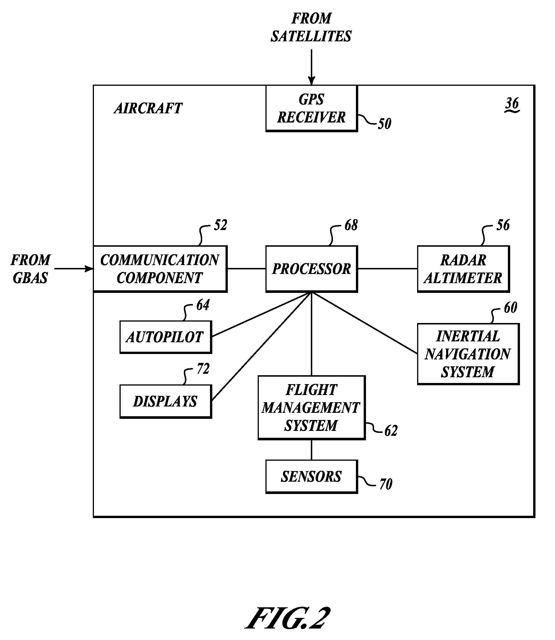
[0019]The present invention provides systems and methods for accurately identifying a location of an aircraft in order to provide accurate information for aiding in a pilot-controlled or an autopilot-controlled CAT II / III instrument landing approach. Referring to FIG. 1, an exemplary system 20 includes a global navigation satellite system (GNSS) 24 and a ground-based augmentation system (GBAS) 30. The GNSS 24 includes a plurality of satellites 26. An aircraft 36, when beginning an instrument landing approach, receives pseudorange information from the GNSS 24 and pseudorange corrections from the GBAS 30. The GBAS 30 also sends detailed terrain data of an area of terrain 40 under the approach that the aircraft 36 is performing. The aircraft 36 determines its position based on the received pseudorange information, the received terrain data information (such as without limitation World Geodetic System (WGS)-84 data) and radar altimeter information. The determined position information is...


PUM


Abstract

A method and system are provided for performing satellite-supported landings in CAT II / III type landing conditions. An exemplary system includes a communication component, a positioning system, a radar altimeter, and a processor. The communication component receives terrain data information related to an instrument landing approach. The positioning system determines position of the aircraft. The radar altimeter generates altitude information of the aircraft. The processor is coupled to the communication component, the positioning system, and the radar altimeter. The processor determines an aircraft altitude based on the determined position of the aircraft, received terrain data information, and the generated altitude information.

Description

FIELD OF THE INVENTION[0001]This invention relates generally to aircraft and, more specifically, to aircraft landing guidance systems.BACKGROUND OF THE INVENTION[0002]The aviation industry is developing new approach and landing systems based on the global navigation satellite system (GNSS). A GNSS Landing System (GLS) integrates satellite and ground-based navigation information to provide position information required for approach and landing guidance. The potential benefits of the GLS include significantly improved take-off and landing capability at airports worldwide, reduced cost, and improved instrument approach service at additional airports and runways. GLS may eventually replace the Instrument Landing System (ILS) which is the current standard for civil precision approach and landing systems.[0003]One of most demanding aviation applications for GNSS is low visibility approach and landing. The most demanding of these precision approach and landing operations in the US are call...

Claims


Application Information

Patent Timeline
Patent Type & Authority Patents(United States)
IPC IPC(8): G06F19/00G01C23/00
CPCG01C23/00G01S19/15G01S19/48
Inventor MURPHY, TIMOTHY A.
Owner THE BOEING CO
Why Eureka
Try Eureka