Navigation method and system for accurately estimating positions of street address numbers

a technology of street address and accurate estimation, applied in the field of navigation method and system, can solve the problems of inaccurate position of intermediate addresses and map data, and achieve the effect of accurately determining the location of street addresses, accurately determining the position of street addresses, and improving the accuracy of location

Active Publication Date: 2008-06-03
ALPINE ELECTRONICS INC
View PDF8 Cites 58 Cited by
  • Summary
  • Abstract
  • Description
  • Claims
  • Application Information

AI Technical Summary

Benefits of technology

[0013]It is, therefore, an object of the present invention to provide a navigation system that improves accuracy in determining the location of a target address.
[0014]It is another object of the present invention to provide a navigation method and apparatus which is able to use building footprint information in combination with street segment data for more accurately defining a position of a destination.
[0015]It is a further object of the present invention to provide a navigation method and apparatus which is able to use latitude / longitude information of POI (point of interest) in the map data in combination with street segment data to more accurately defining a position of a destination.
[0016]It is a further object of the present invention to provide a navigation method and apparatus which is able to use both building footprint information and latitude / longitude information of POI (point of interest) in the map data in combination with street segment data to more accurately defining a position of a destination.
[0022]According to the present invention, the navigation method and system improve accuracy in determining the location of the target address. The navigation method and system of the present invention is able to use building footprint information in combination with street segment data to accurately determining a position of an street address number. Further, the navigation method and system of the present invention is able to use latitude / longitude information of POI (point of interest) in the map data in combination with the street segment data to accurately determining a location of a street address number. Further, the navigation method and system of the present invention is able to use both the building footprint information and the latitude / longitude information of POI (point of interest) in the map data in combination with the street segment data to accurately define a position of a selected destination.

Problems solved by technology

Thus, the map data does not always include an accurate position of street address for each and every address number on the street.
Thus, although the address number and position at each end (1000 and 4000) of the street segment are accurate, positions of intermediate addresses are not always accurate.

Method used


Image

  • Navigation method and system for accurately estimating positions of street address numbers
  • Navigation method and system for accurately estimating positions of street address numbers
  • Navigation method and system for accurately estimating positions of street address numbers

Examples


Embodiment Construction

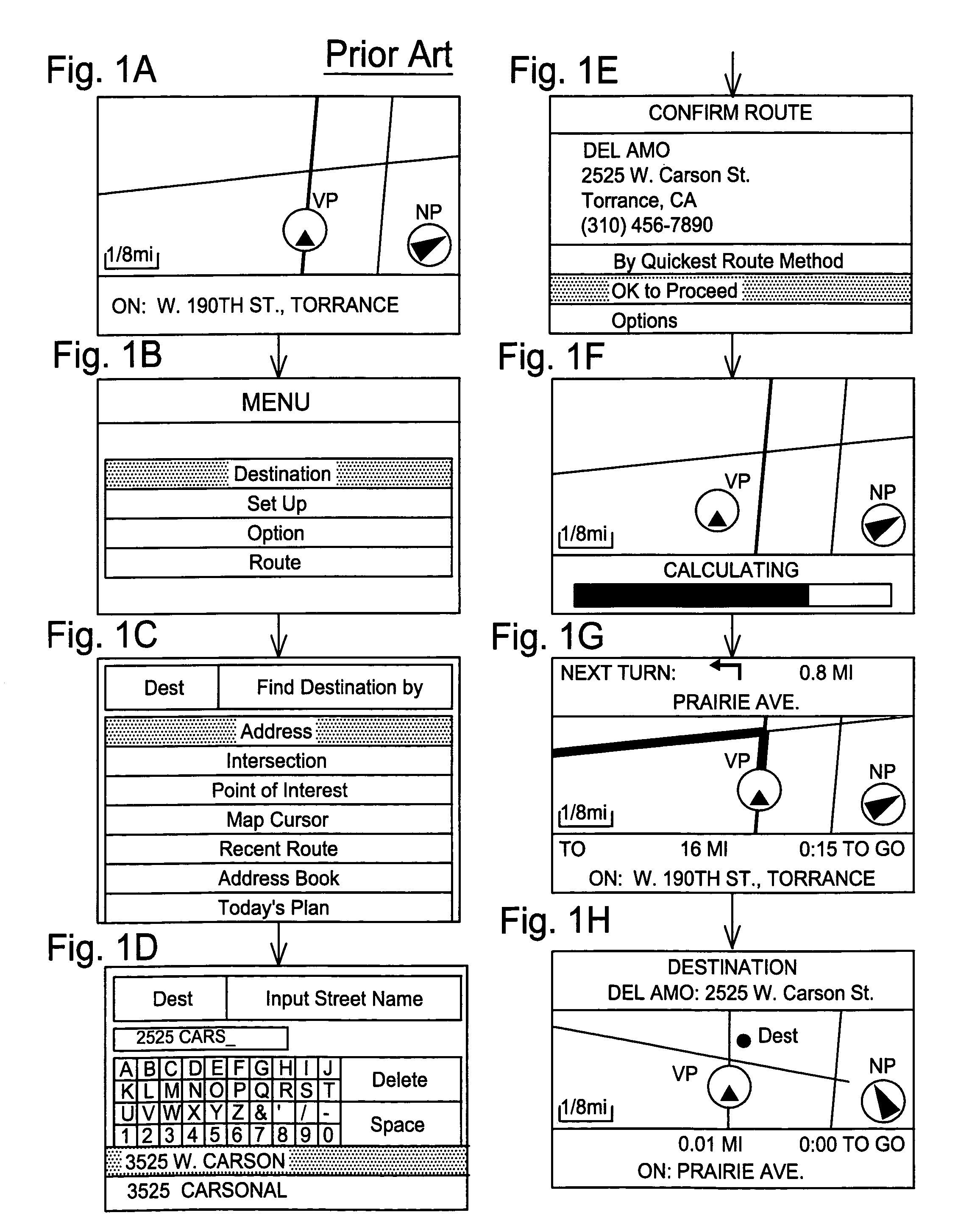
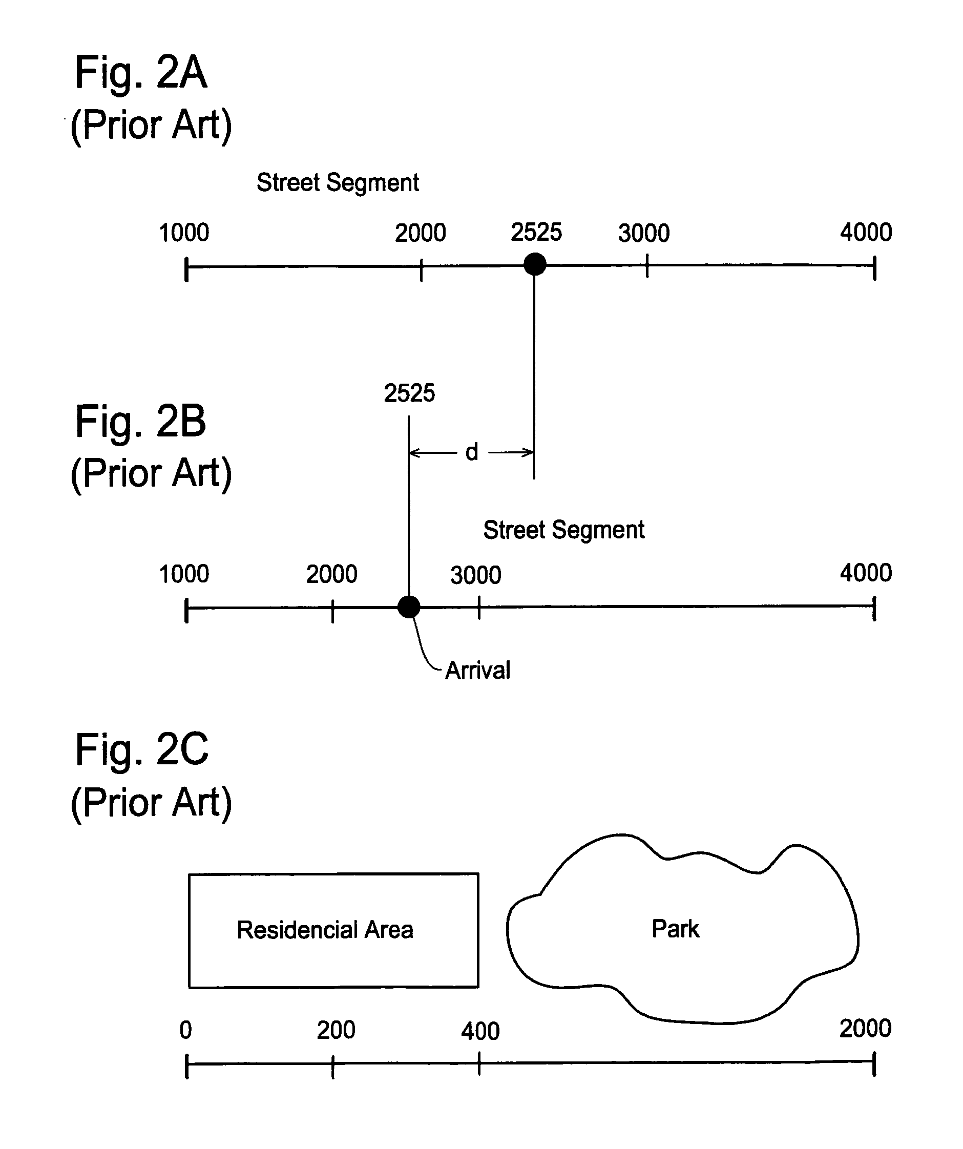
[0034]The present invention will be described in detail with reference to the accompanying drawings. The navigation system of the present invention is designed to accurately determine an actual position of a street address number with use of polygon data of a large facility, such as building footprint information retrieved from the map data. The navigation system of the present invention is also designed to accurately determine an actual position of a street address number with use of latitude / longitude information of POI (point of interest) retrieved from the map data.

[0035]Generally, the map database for a navigation system is available in the market through a map data provider. In addition to basic map data, the recent map database includes geographic polygon data for relatively large structures such as shopping malls, stadiums, universities, etc., and POI position data defined by latitude / longitude information. Further, building footprint information are also beginning to be pro...


PUM


Abstract

A navigation method and system determines a more accurate position of a street address number with use of building footprint information or latitude / longitude information of POI (point of interest), thereby accurately defining a position of a destination. When a user specifies a street address number as his destination, the navigation system retrieves the street segment that should include the location of the specified address number therein. The navigation system also checks the map data as to whether there is any building footprint data or POI position data associated with the street segment. The navigation system selects absolute locations on the street segment based on the building footprint data or the POI position data and determines the location of the specified address number by interpolating between two absolute locations.

Description

FIELD OF THE INVENTION[0001]This invention relates to a navigation method and system, and more particularly, to a navigation method and system that determines a more accurate position of a particular street address number derived from a map database with use of building footprint information or latitude / longitude information of POI (point of interest), thereby accurately defining a position of a destination.BACKGROUND OF THE INVENTION[0002]A navigation system performs travel guidance for enabling a user to easily and quickly reach the selected destination. A typical example is a vehicle navigation system where a vehicle carries a navigation function. Such a navigation system detects the position of the user or user's vehicle, and reads out map data pertaining to an area at the current vehicle position from a data storage medium in the navigation system. The navigation system displays a map image on a monitor screen while superimposing a mark representing the current location of the ...

Claims


Application Information

Patent Timeline
Patent Type & Authority Patents(United States)
IPC IPC(8): G01C21/00
CPCG01C21/3644G01C21/3679
Inventor DE SILVA, ANDREW S.PASCUAL, JOEYYOKOTA, TATSUO
Owner ALPINE ELECTRONICS INC
Why Eureka
Try Eureka