Image display

a technology of image display and display screen, applied in the field of image display, can solve problems such as stress on users, and achieve the effect of high user satisfaction

Inactive Publication Date: 2009-05-26
APPLE INC
View PDF32 Cites 35 Cited by
  • Summary
  • Abstract
  • Description
  • Claims
  • Application Information

AI Technical Summary

Benefits of technology

[0015]The present invention was accomplished in order to solve the above-described problem, and it is an object of the present invention to provide an image display, which is adopted specifically in a navigation system, properly using both displays of real images such as air photo images and map images that are prepared with map data, thereby resulting in a higher satisfaction for a user.

Problems solved by technology

On the other hand, when the reduction ratio is small (resulting in a wide-area display), the situation of the facility sometimes cannot be known in detail, thereby leading to a stress on the user.

Method used


Image

  • Image display
  • Image display
  • Image display

Examples


first embodiment

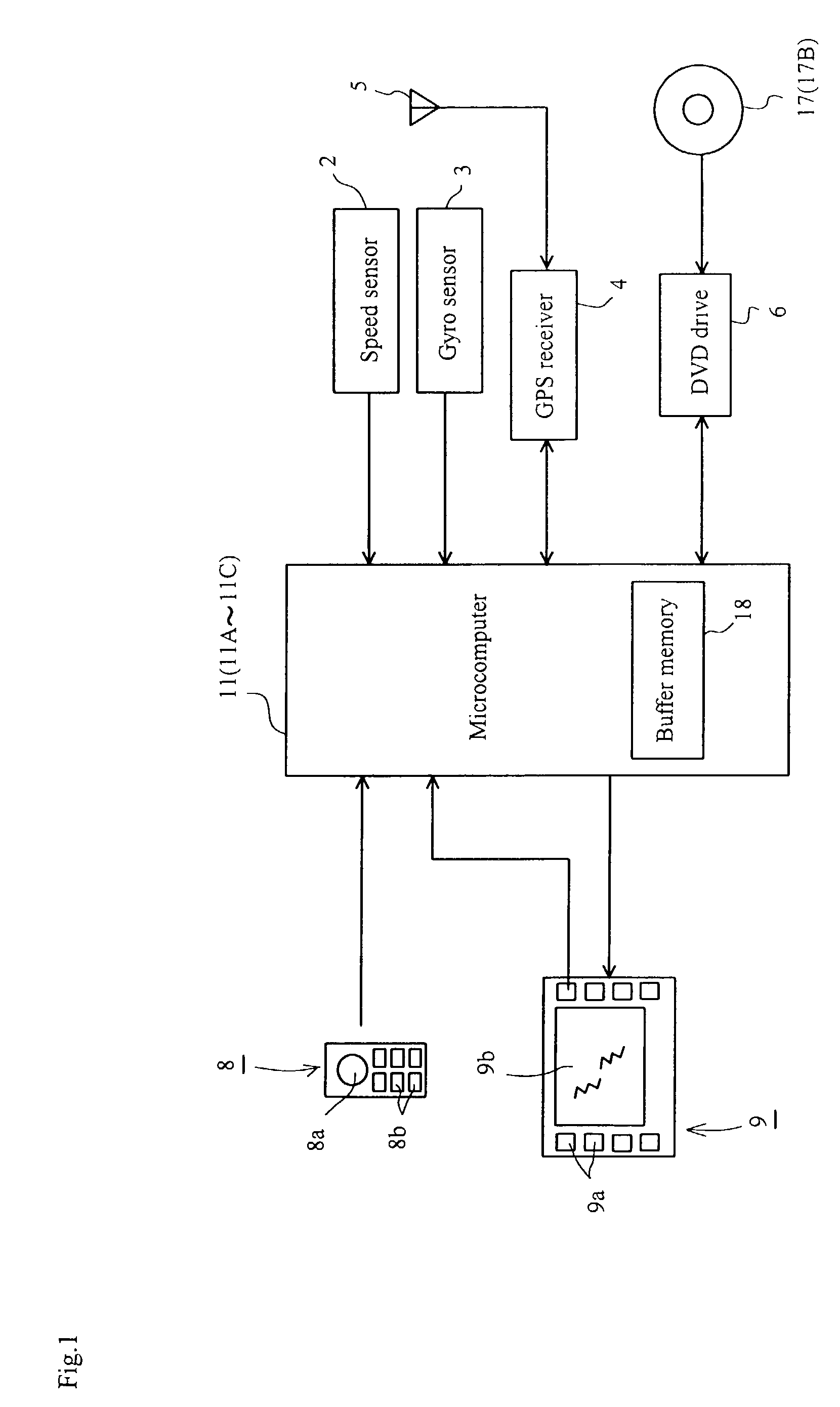
[0144]The preferred embodiments of the image display according to the present invention are described below by reference to the drawings annexed hereto. FIG. 1 is a block diagram schematically showing the principal part of a navigation system in which an image display according to a first embodiment of the present invention is adopted. Here, the same components as those of the navigation system shown in FIG. 34 are similarly marked, and thus are not described below.

[0145]A speed sensor 2 and a gyro sensor 3 are connected to a microcomputer 11, which concludes the position of one's car (vehicle) based on the computed distance traveled and the direction in which the car is heading (self-contained navigation). In addition, a GPS receiver 4 is connected to the microcomputer 11, which concludes the position of one's car based on GPS signals (GPS navigation).

[0146]A DVD drive 6, which can capture electronic map data, photo data and the like from a DVD-ROM 17 (a storage device such as a CD...

second embodiment

[0171]A navigation system in which an image display according to a second an embodiment of the present invention is adopted will now described below. Here, since the construction of the navigation system in which the image display according to the second embodiment is adopted is similar to that of the navigation system shown in FIG. 1 except for the microcomputer 1, a microcomputer is marked differently and the other constituent elements are not described below.

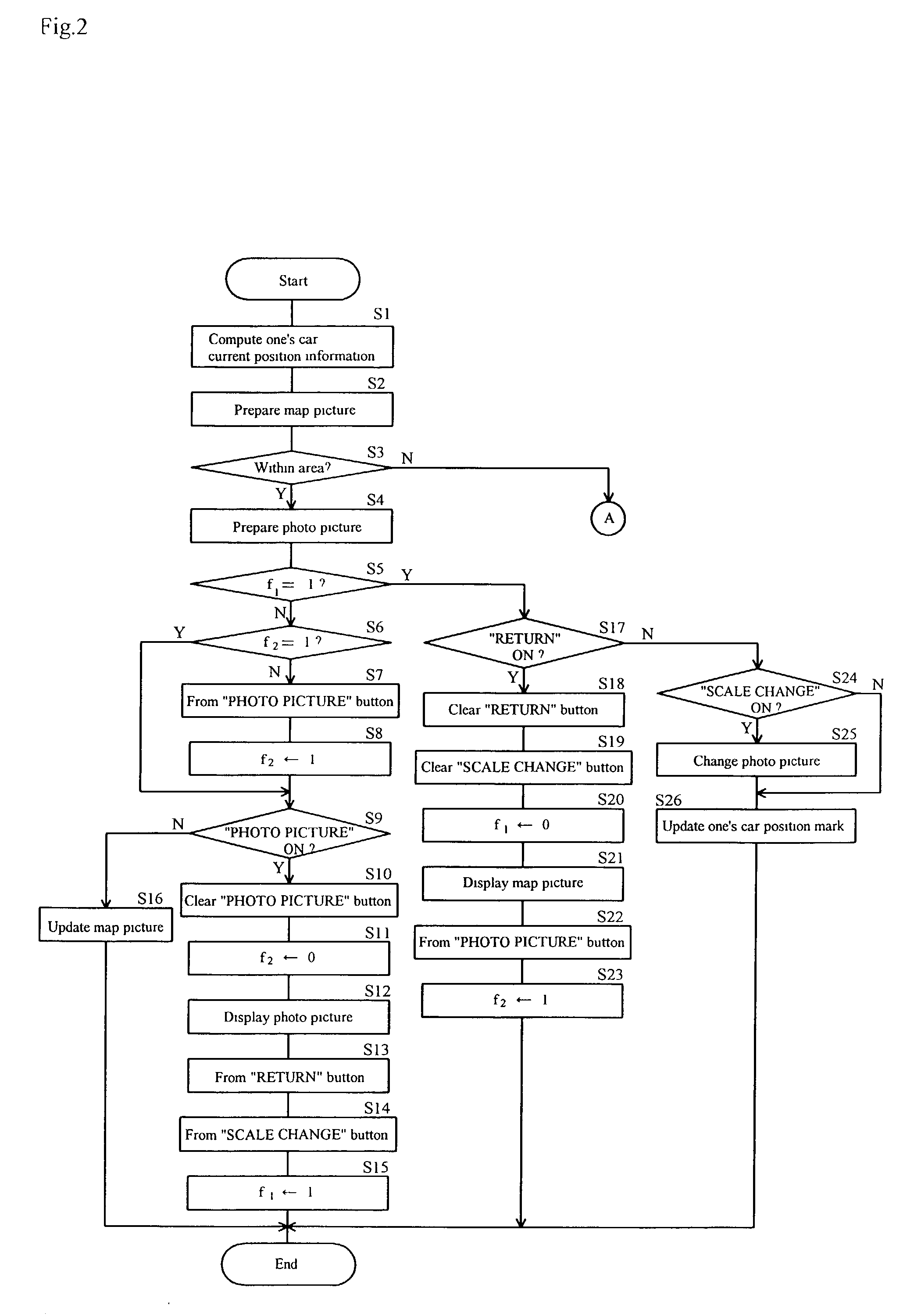
[0172]The processing operation {circle around (2)} which is performed by the microcomputer 11A in the navigation system in which the image display according to the second embodiment is adopted is described below by reference to a flowchart shown in FIG. 7. First, in Steps S41-43, it is judged whether the below-described flags f3-f5 are 1 or not. When the flags f3-f5 each are judged not to be 1, the operation goes to Step S44, wherein it is judged whether or not the selection of a route was completed with entries of a goal and...

third embodiment

[0187]A navigation system in which an image display according to a third embodiment of the present invention is adopted will now be described below. Here, since the construction of the navigation system in which the image display according to the third embodiment is adopted is similar to that of the navigation system shown in FIG. 1 except for the microcomputer 11 and the DVD-ROM 17, a microcomputer and a DVD-ROM are marked differently and the other constituent elements are not described below.

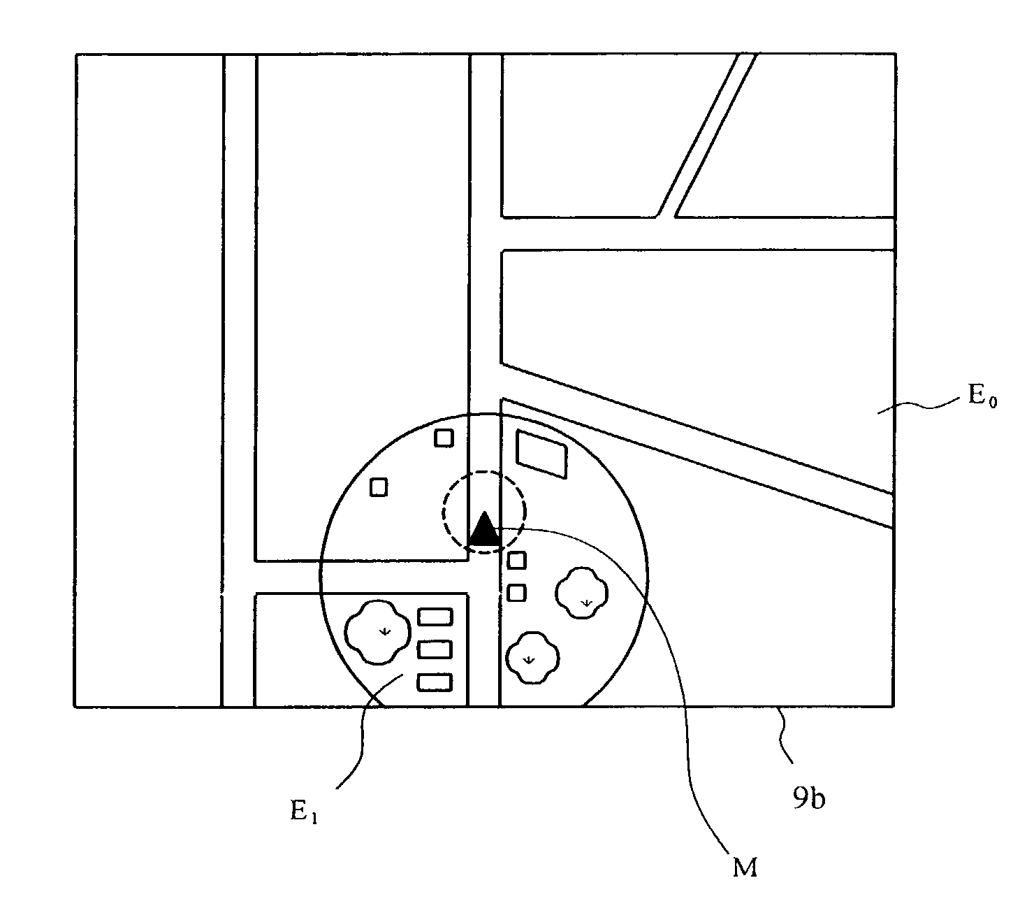
[0188]In the DVD-ROM 17B, electronic map data covering, for instance, an entire country, photo data such as satellite photographs or air photographs showing the surface of the earth, and detailed data (e.g. data regarding admission fees, business days and the like) regarding prescribed spots (e.g. places of amusement and restaurants) are recorded. Here, the recorded areas (such as the major cities) concerning the photo data are limited.

[0189]The processing operation {circle around (3)} which i...


PUM


Abstract

An image display whereby one can extremely easily know the current position of one's own vehicle and also grasp the actual situation around the current position of the vehicle, and with which the user gets highly satisfied. The image display includes a display device to display a photo picture on a prescribed reduced scale which is prepared based on photo data on a first scale that is read from a storage device in which photo data of two or more types in different scales to one area is stored, and a display switching device to conduct display switching according to a user's command to a photo picture on another reduced scale which is prepared based on photo data in a second scale that is different from the first scale.

Description

BACKGROUND OF THE INVENTION[0001]1. Field of the Invention[0002]The present invention relates to an image display and, more particularly, to an image display, which is adopted specifically in a navigation system, using real image data corresponding to images such as satellite photographs or air photographs of the surface of the earth.[0003]2. Description of the Relevant Art[0004]FIG. 34 is a block diagram schematically showing the principal part of a navigation system in which a conventional image display is adopted. A speed sensor 2 for acquiring the distance in which a vehicle travels by computing the vehicle speed, and a gyro sensor 3 for acquiring the direction in which the vehicle is headed are connected to a microcomputer 10, which concludes the position of one's car (vehicle) based on the computed distance in which the vehicle has traveled and the direction in which the vehicle is heading (self-contained navigation).[0005]A GPS receiver 4, which receives GPS signals from sate...

Claims


Application Information

Patent Timeline
Patent Type & Authority Patents(United States)
IPC IPC(8): G08G1/137G08G1/13G01C21/26G08G1/0969G01C21/36
CPCG01C21/3647G01C21/367G01C21/3682G08G1/0969
Inventor KAMIKAWA, NORIYUKIMATSUMOTO, YASUOOHTA, TAKASHIYAMAGUCHI, TAKAOFUJIMOTO, SHOJITAKEUCHI, HIROSHI
Owner APPLE INC
Why Eureka
Try Eureka