Map display device and map display method

a map display and map technology, applied in maps/plans/charts, navigation instruments, instruments, etc., can solve the problems of increasing the size and cost of the device, and achieve the effect of simple calculation, easy display and simple computational process

Inactive Publication Date: 2011-10-18
NAVITIME JAPAN CO LTD
View PDF18 Cites 63 Cited by
  • Summary
  • Abstract
  • Description
  • Claims
  • Application Information

AI Technical Summary

Benefits of technology

[0064]In the invention according to the first through fourth aspects, the map display device is provided with means for creating a plane figure for a bird's-eye view, shift amount storage means, building position determination means, and map data duplication means, wherein the means for creating a plane figure for a bird's-eye view creates a bird's-eye-view plane figure for creating a bird's-eye view from the map data composed of vector data, and the figure data duplication means duplicates and draws a bird's-eye-view plane figure while shifting the plane figures of buildings upward on a screen in sequence from the building positioned farthest away in the bird's-eye view according to the shift amount on the basis of a building position determined by the building position determination means and on the basis of a shift amount stored by the shift amount storage means.
[0065]Accordingly, a bird's-eye view can be displayed merely by subjecting the vector data of the buildings to an affine transformation in sequence from the building positioned farthest in the bird's-eye view to create plane figures (polygons), duplicating and drawing the plane figures a number of times that is in accordance with the height of the building while shifting the plane figures a prescribed shift amount upward on the screen. Since the affine transformation as such is a simple calculation, and the plane figure is simply duplicated thereafter, a building can be drawn as a three-dimensional representation by an extremely simple computational process in comparison to the processing for computing a three-dimensional image of a building. A bird's-eye view can therefore be easily displayed even when the CPU of the map display device has limited processing capability.
[0066]In the invention according to the fifth aspect, the shift amount stored by the shift amount storage means in the invention according to the first aspect has a plurality of values according to the display region of the display means, and the value of the amount of upward shift in the display region is set so as to be smaller than the amount of downward shift in the display screen. Accordingly, buildings at the top (farther away in the bird's-eye view) of the screen can be displayed small, and buildings at the bottom (closer in the bird's-eye view) of the screen can be displayed large to display an appropriate three-dimensional figure.
[0067]In the invention according to the sixth through ninth aspects, the map display device comprises means for creating a plane figure for a bird's-eye view, shift amount storage means, building position determination means, and figure data duplication means; the means for creating a plane figure for a bird's-eye view creates bird's-eye-view plane figures of buildings in sequence from the building positioned farthest away in a bird's-eye view on the basis of a building position determined by the building position determination means, and draws a first layer of plane data; and the figure data duplication means duplicates and draws the first layer of plane data while shifting the first layer of plane data upward on a screen according to the shift amount on the basis of the shift amount stored by the shift amount storage means, and displays the bird's-eye view.
[0068]Accordingly, since the vector data of the buildings are subjected to an affine transformation in sequence from the building positioned farthest in the bird's-eye view to create plane figures (polygons), a first layer of plane data are drawn, and the first-layer layer plane figure is merely duplicated thereafter, a building can be drawn as a three-dimensional representation by an extremely simple computational process in comparison to the processing for computing a three-dimensional image of a building. A bird's-eye view can therefore be easily displayed even when the CPU of the map display device has limited processing capability.
[0069]In the invention according to the tenth aspect, the shift amount stored by the shift amount storage means in the invention according to the sixth aspect has a plurality of values according to the display region of the display means, and the value of the amount of upward shift in the display region is set so as to be smaller than the amount of downward shift in the display screen. Accordingly, buildings at the top (farther away in the bird's-eye view) of the screen can be displayed small, and buildings at the bottom (closer in the birds-eye view) of the screen can be displayed large to display an appropriate three-dimensional figure.

Problems solved by technology

The vehicle-mounted navigation device described above is a standalone navigation device that has map data or a route search function, but such a navigation device must be provided with all the functions necessary for navigation, which increases the size and cost of the device.

Method used


Image

  • Map display device and map display method
  • Map display device and map display method
  • Map display device and map display method

Examples


example 1

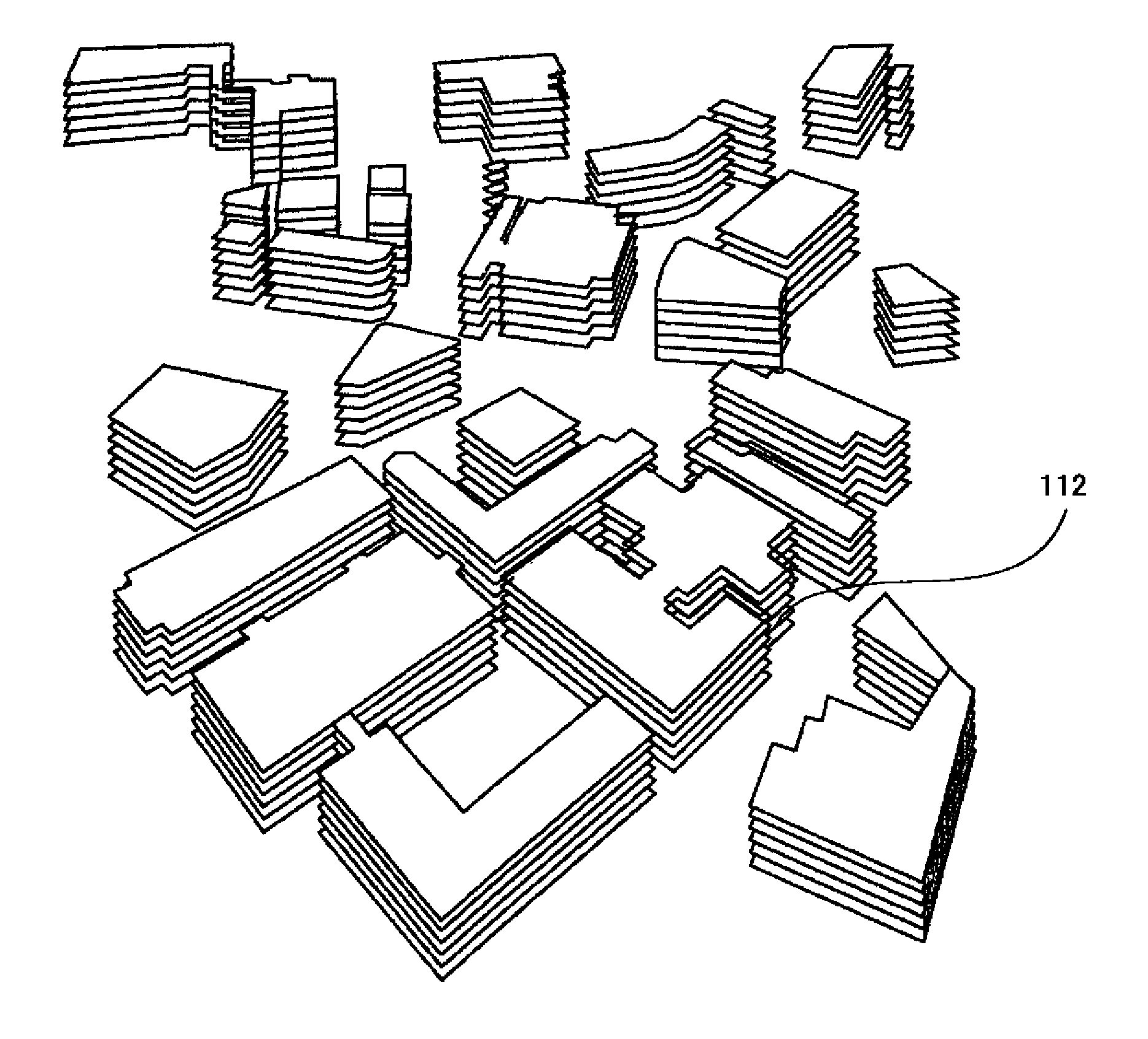
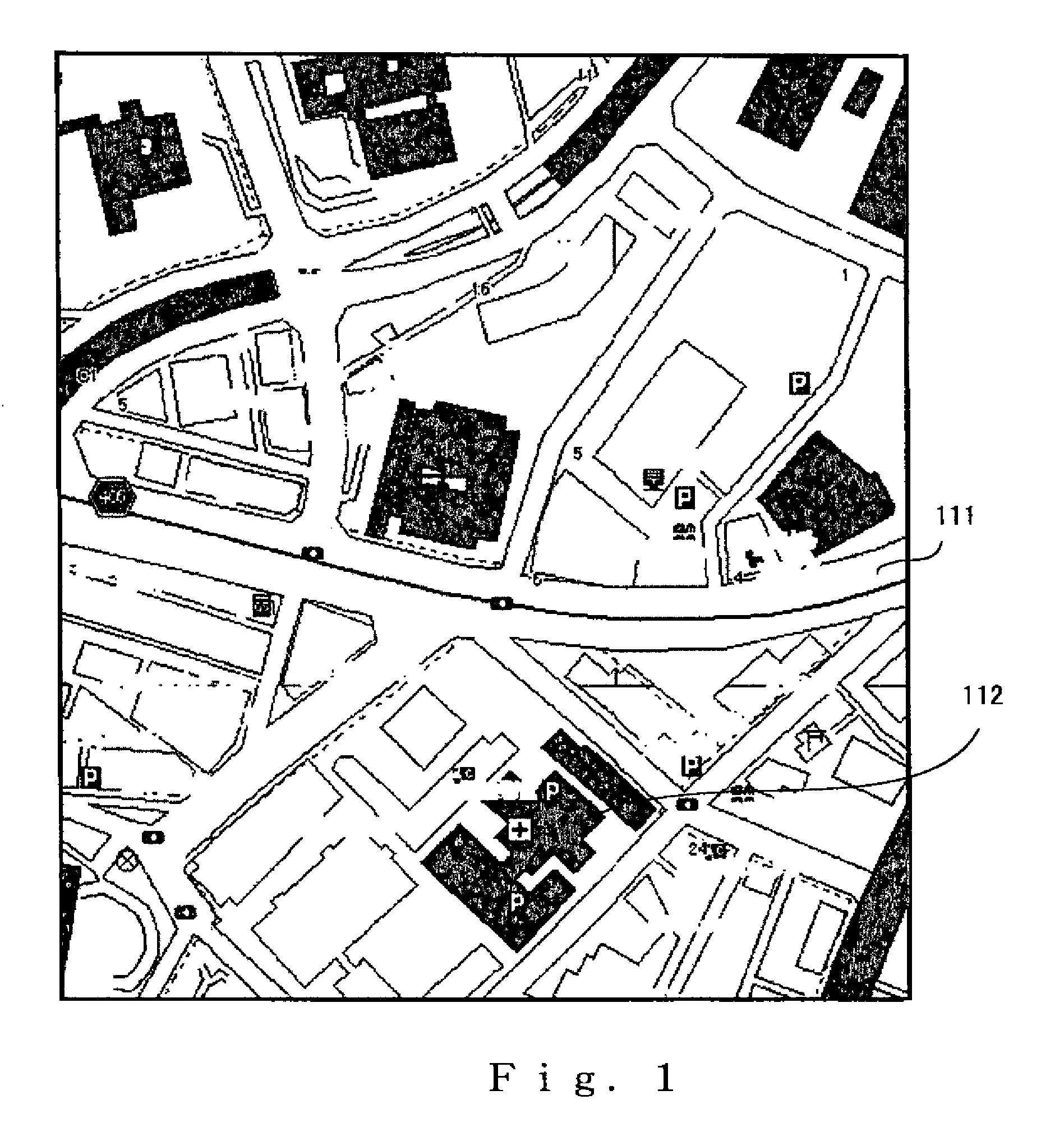
[0123]The map displayed in the display means of the map display device according to Example 1 of the present invention is displayed by presenting a plan view of vector map data that are received from a route search server by a navigation application for performing a route search, as shown in FIG. 1. FIG. 1 is monochrome, but lots or buildings are indicated by polygons and color-coded by a color that is determined by the attributes of the lot or building. Specifically, a road 111 is drawn in the displayed map as shown in FIG. 1, and the outline of the lot or building of the building 112 is drawn in the corresponding position on the map. As previously mentioned, the map data are thus accumulated as a map data DB (database) in the route search server as map data that are separate from the data of the road network used for route searching, and the map data are transmitted according to a request from the navigation terminal device, or are transmitted to the navigation terminal device alo...

example 2

[0146]The display method in Example 1 performed a drawing routine for displaying the buildings at a uniform height, but a display method may also be employed that draws the buildings accurately according to the height or number of floors. Example 2 is a flowchart showing the sequence of routines in this display method. The map display system 10 is configured in the same manner as in Example 1.

[0147]Example 2 is a method for reproducing a building relatively faithfully when the number of floors is included in the building data. FIG. 8 is a flowchart showing the sequence of display routines according to Example 2 of the present invention. In the routine of step S20, the building position determination means 220 extracts buildings at the top of the screen, i.e., buildings that are at distant positions in the bird's-eye view. Then, in the routine of step S21, the means for creating a plane figure for a bird's-eye view 218 affine transforms vector data that indicate the shapes of the bui...

example 3

[0151]For a pedestrian, it may not be necessary to faithfully represent the height of the buildings. The number of floors is unimportant particularly for tall buildings, and only the fact that the building is tall is important, so the map display device is adequate insofar as the building can be depicted as tall. Therefore, the building heights in Example 3 of the present invention are classified into the two height types tall and short, and there are two numbers of times which the bird's-eye-view plane figures (polygons) are duplicated and drawn. The map display system 10 of Example 3 is configured in the same manner as the map display system 10 in Example 1.

[0152]FIG. 10 is a flowchart showing the sequence of display routines according to Example 3 of the present invention. In the routine of step S30, the building position determination means 220 extracts buildings at the top of the screen, i.e., buildings that are at distant positions in the bird's-eye view. Then, in the routine ...


PUM


Abstract

A map display device and a map display method, in which a building in a map is formed as a pseudo three-dimensional figure and arithmetic processing to display the figure as a bird's-eye view is simplified. The map display device 20 for displaying map data, formed from vector data, on a display means has a plane figure-for-bird's-eye-view creation means 218, a shift amount storage means 219, a building position determination means 220, and a figure data copying means 221. The plane-figure-for-bird's-eye-view creation means 218 creates, from the map data formed from vector data, a plane figure for creating a bird's-eye view. The figure data copying means 221 copies and draws the plane figure to display a bird's-eye view. This is performed based on the positions of buildings determined by the building determination means 220 and on the shift amounts stored in the shift amount storage means 219, and in this process, the plane figures are shifted upward on a display screen according to the shift amounts, and the copying and drawing are made one by one from a building positioned on the far side in the bird's-eye view.

Description

TECHNICAL FIELD[0001]The present invention relates to a map display device and a map display method used in a navigation system or the like, and particularly relates to a map display device and a map display method in which buildings on a map are rendered as three-dimensional shapes similar to the buildings, and arithmetic processing for displaying a bird's-eye view is simplified.BACKGROUND ART[0002]Car-mounted navigation devices have been provided in the past for guiding the driver of an automobile along the optimum route from a departure point to a destination point. A conventional navigation device has a CD-ROM, IC card, or other map data storage device in which map data are recorded; a display device; and a gyroscope, a GPS (Global Positioning System), a speed sensor, and other vehicle movement detection devices and the like for detecting the current position and the current bearing of the vehicle. Map data that include the current position of the vehicle are read from the map d...

Claims


Application Information

Patent Timeline
Patent Type & Authority Patents(United States)
IPC IPC(8): G06T15/00G06T17/05
CPCG01C21/3638G09B29/10
Inventor KIKUCHI, SHINSAKAMOTO, HIROSHI
Owner NAVITIME JAPAN CO LTD
Why Eureka
Try Eureka