GPS pathfinder cell phone and method

a pathfinder and cell phone technology, applied in the field of gps pathfinder cell phone and method, can solve the problems of not being equipped with a path to follow or an area, not being able to associate a written description or code with a specific way point in the unit, and being far too complicated for the common user without prior instructions, so as to achieve the effect of optimizing the effectiveness of the uni

Active Publication Date: 2012-04-10
SPHINX IND INC
View PDF33 Cites 17 Cited by
  • Summary
  • Abstract
  • Description
  • Claims
  • Application Information

AI Technical Summary

Benefits of technology

[0022]The present invention is a device and system for use in the various stages of operations before and after a disaster. The device incorporates a cell phone provided with GPS which can operate on either CDMA, GSM, TDMA and / or IDENT (push to talk) networks. Maps of areas to be searched are uploaded into the device and the areas covered during the search are retained in the device's memory. A unique feature enables the searcher to quickly indicate a specific need or service at a particular location during the search. Areas that have been searched during a day are downloaded to a base unit and areas to be searched the following day are uploaded to the portable units at the beginning of the next day—all via wireless technology. The software employed on the cell phones is designed to permit the cell phone to automatically or manually download the information stored as data to a laptop “server” or other device which functions as a “server” when the cell phone is within Bluetooth® communication range of the server computer. Likewise, customization of the forms on the cell phone can also be made via Bluetooth® communication from a server and / or a laptop “server”. Thus the cell phones are “talking” or communicating directly to the laptop “servers” without the use of cell towers or the Internet, which totally disconnected environment is the setting or situation confronting responders in a major disaster. Maps of the areas to be searched are uploaded into the cell phone or device and the areas to be covered during the search are retained in the cell phone's or device's memory. A unique feature of the present invention enables a searcher to quickly indicate a specific need or service at a particular location during the search. Areas that have been searched during the day are downloaded to a base unit and areas to be searched the following day or days are uploaded to the cell phone or portable device at the beginning of the next day. All of this is accomplished employing wireless technology. Push to talk radios on units also would enable the searchers to audibly communicate with each other. This software also permits the information on the cell phone with GPS to be down loaded to “servers” when the cell phone with GPS is within Bluetooth® communication range. This system relies upon common software designs which can incorporate elements of Lennox, Windows, Java, and other technologies programmed into this application to allow the cell phones to optimize their effectiveness.
[0027]It is yet a further objective of the instant invention to provide a cell phone equipped with GPS and having GPS functions with Bluetooth® which can indicate the locations of other similar devices without input from the operators of the other devices. Real time tracking is thus achieved as well.

Problems solved by technology

While this unit can download a given day's track to a base unit, it does not have Bluetooth® technology and therefore must be hard wired to the base unit to store its track.
Further, the use of the unit is far too complicated for the common user without prior instructions.
In addition the user cannot associate a written description or code with a specific way point in the unit.
While these units can download a path traversed by a user, they are not equipped to be uploaded with a path to follow or an area to search.
Further, they cannot associate a specific written condition or code with a way point.
While these units can download a path traversed by a user, they are not equipped to be uploaded with a specific path to follow or an area to search.
In addition they cannot associate a written description or code with a specific way point.
Given the number of the units being used after an incident, hard wiring for uploads and downloads is not practical and is far too time consuming.

Method used


Image

  • GPS pathfinder cell phone and method
  • GPS pathfinder cell phone and method
  • GPS pathfinder cell phone and method

Examples


Embodiment Construction

[0042]While the present invention is susceptible of embodiment in various forms, there is shown in the drawings and will hereinafter be described a presently preferred, albeit not limiting, embodiment with the understanding that the present disclosure is to be considered an exemplification of the present invention and is not intended to limit the invention to the specific embodiments illustrated.

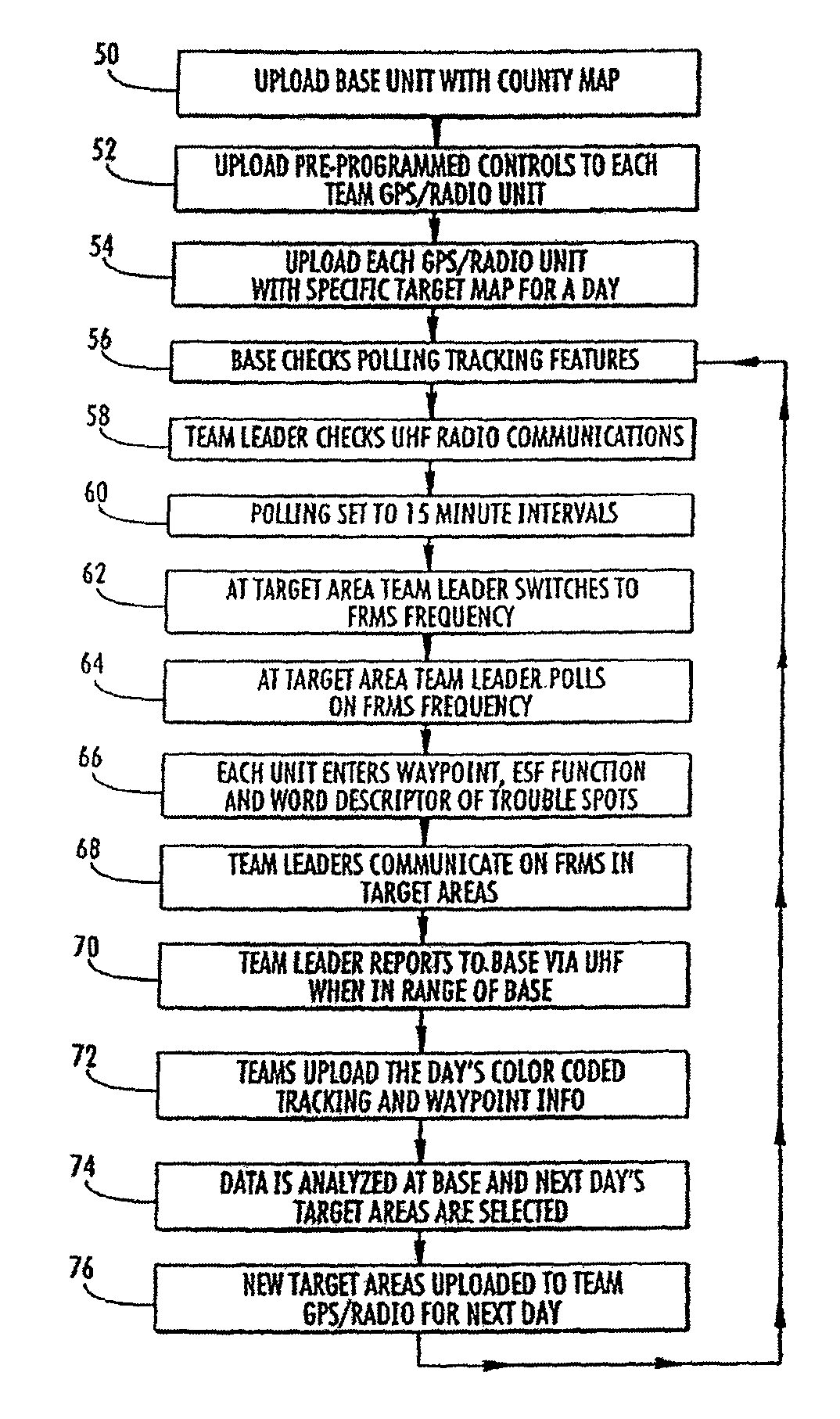
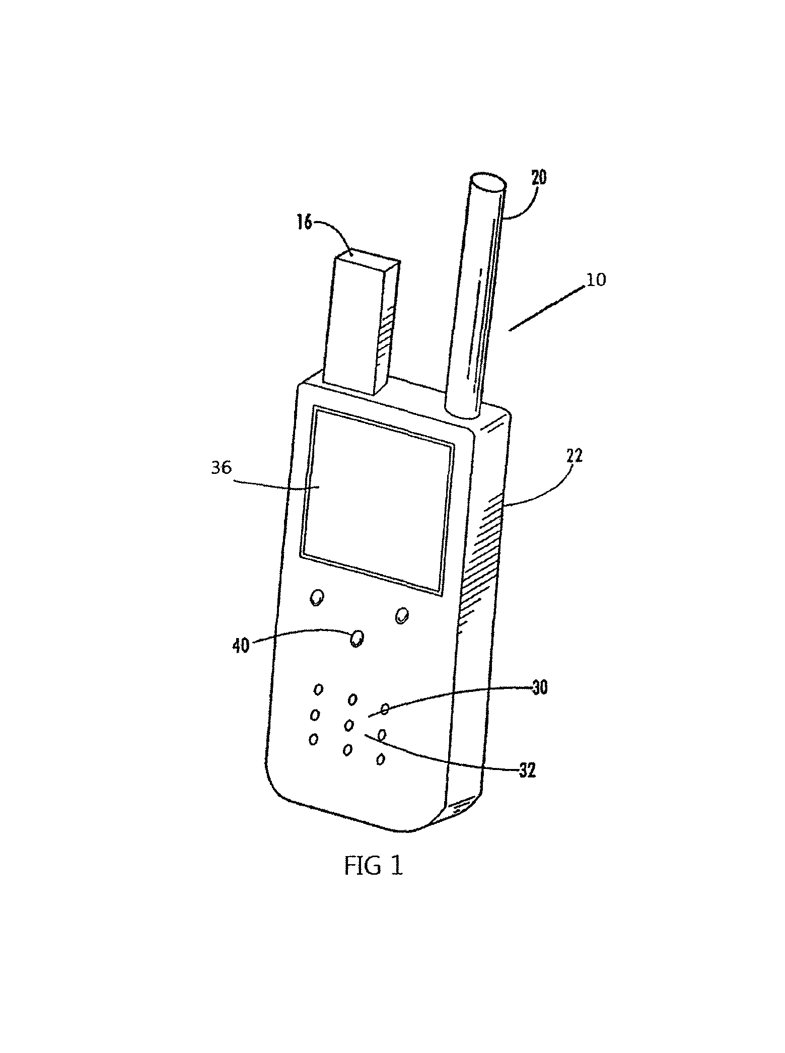
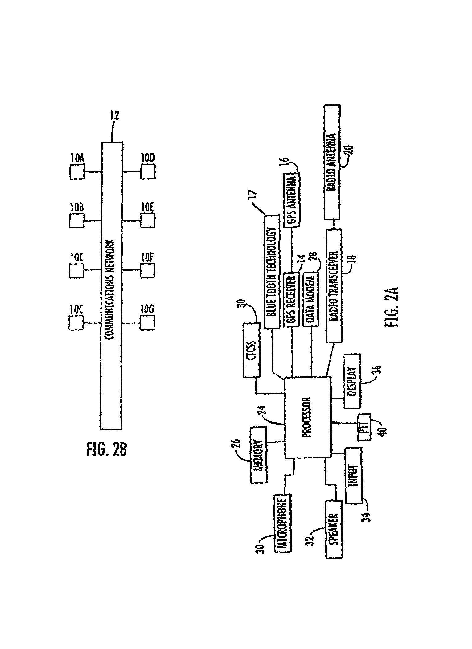
[0043]A portable GPS receiver is combined with a radio transceiver into one unit 10 in a preferred embodiment of the present invention as illustrated in FIG. 2A. A plurality of other similar GPS / radio units 10A-10G communicate with each other utilizing a communications network 12, as illustrated in FIG. 2B. The GPS / radio units 10A-10G determine their various locations utilizing GPS and can then transmit these locations to the other units over a wireless network. In this manner the locations of all the units can be determined and monitored by any one of the units. The preferred embodiment of ...


PUM


Abstract

A device and system for use in emergency management operations before and after a disaster. The device incorporates a GPS and a radio with very simplified, pre-programmed instructions which are uploaded automatically in the device's memory via wireless technology prior to the unit's first use at a disaster site. Maps of areas to be searched are uploaded into the device and the areas covered during the search are retained in the devices' memory. A unique feature enables the searcher to quickly indicate a specific need or service at a particular location during the search, which information automatically is geocoded and time / date stamped once the user saves the information inputted. Via wireless technology areas that have been searched during an operational period are downloaded to a base unit and areas to be searched the following operational period are uploaded to the portable units at the beginning of the day. Radios on the units can enable the searchers to audibly communicate with each other without cell towers. The system can be employed by cleanup teams, insurance adjusters, and any number of post incident response teams both focused on short and long term recovery operations. The entire system is designed to be self contained to operate when normal cell and Internet systems are damaged or destroyed. The system can quickly organize, sort, and edit the data collected by field users for daily and future analysis and documentation or any and all disaster operations.

Description

RELATED APPLICATIONS[0001]This application is a continuation-in-part of application Ser. No. 11 / 696,532, filed Apr. 4, 2007 now abandoned, entitled, “GPS PATHFINDER METHOD AND DEVICE”, the entirety of which is incorporated herein by reference.FIELD OF THE INVENTION[0002]The present invention relates to a system for a variety of operations before and after a disaster. The system is designed to be used by a wide variety of responders to methodically search for victims in areas affected by disasters, collect rapid human needs and property damage assessments, and identify and deliver unmet needs to the vulnerable populations. Field operations are precisely documented by geocoding and time / date stamps as well as are retained within the system for future analysis.BACKGROUND OF THE INVENTION[0003]The present invention relates to a disaster response and recovery system which incorporates a methodical approach to a variety of disaster operations. The system is designed so that individuals un...

Claims


Application Information

Patent Timeline
Patent Type & Authority Patents(United States)
IPC IPC(8): G01S19/03G08B1/08G01S19/17G01S19/02H04M1/72418H04M1/72457
CPCG01S19/42G06Q40/08G08B21/0269G08B27/001H04M1/72536H04M1/72572H04M2250/10H04W4/02H04W64/00H04W4/024H04M1/72418H04M1/72457H04W4/029
Inventor LEWIS, SCOTT
Owner SPHINX IND INC
Why Eureka
Try Eureka