
GPS equipped devices that utilize geographical navigation bundles

a technology of geographical navigation and navigation bundles, applied in the field of navigation devices, can solve the problem that the device cannot display dynamically changed route information, and achieve the effect of avoiding the problem of affecting the display of geographical navigation bundles

Active Publication Date: 2013-02-12
AIRBNB
View PDF17 Cites 17 Cited by
  • Summary
  • Abstract
  • Description
  • Claims
  • Application Information

AI Technical Summary

Benefits of technology

[0011]The present invention discloses a GPS device capable of independent navigation operation that includes a data store for mapping data, a predictive algorithm, and a communication mechanism, where the predictive algorithm automatically determines when to update the navigation data in the data store. The navigation data within the data store can be grouped into one or more different geographical regions. As the GPS device moves among different regions, the navigation data contained within the data store can be dynamically updated to contain data appropriate for the current geographical region within which the GPS device is located. The predictive algorithm can ensure that suitable data is loaded within the data store prior to a time in which the data is actually needed by the GPS device.
[0013]It should be noted that the predictive algorithm can be particularly useful for handling dynamic route changes. For example, the predictive algorithm can automatically acquire navigation information for an unexpected area, after a user of the GPS device has made a wrong turn while driving or taken an unexpected departure from a planned travel path for any reason. Conventional GPS devices and algorithms often rely upon a predetermined route and do not automatically adapt to changes to this predetermined route. While conventional GPS devices often do adapt to route changes, the difficulty in the current state of the art is that unless the GPS user anticipated changes of a magnitude that could necessitate additional detailed data bundles, dynamically changed route information could not be displayed on the device because the data would not be available. The inventive GPS device detailed herein overcomes these problems and provides an extremely flexible, intuitive, and detailed navigation system by delivering the predicted mapping bundles to the device when or before they are needed, relieving the device user from ever having to download any data to the device manually.

Problems solved by technology

Conventional GPS devices and algorithms often rely upon a predetermined route and do not automatically adapt to changes to this predetermined route.
While conventional GPS devices often do adapt to route changes, the difficulty in the current state of the art is that unless the GPS user anticipated changes of a magnitude that could necessitate additional detailed data bundles, dynamically changed route information could not be displayed on the device because the data would not be available.

Method used


Image

  • GPS equipped devices that utilize geographical navigation bundles
  • GPS equipped devices that utilize geographical navigation bundles
  • GPS equipped devices that utilize geographical navigation bundles

Examples


Embodiment Construction

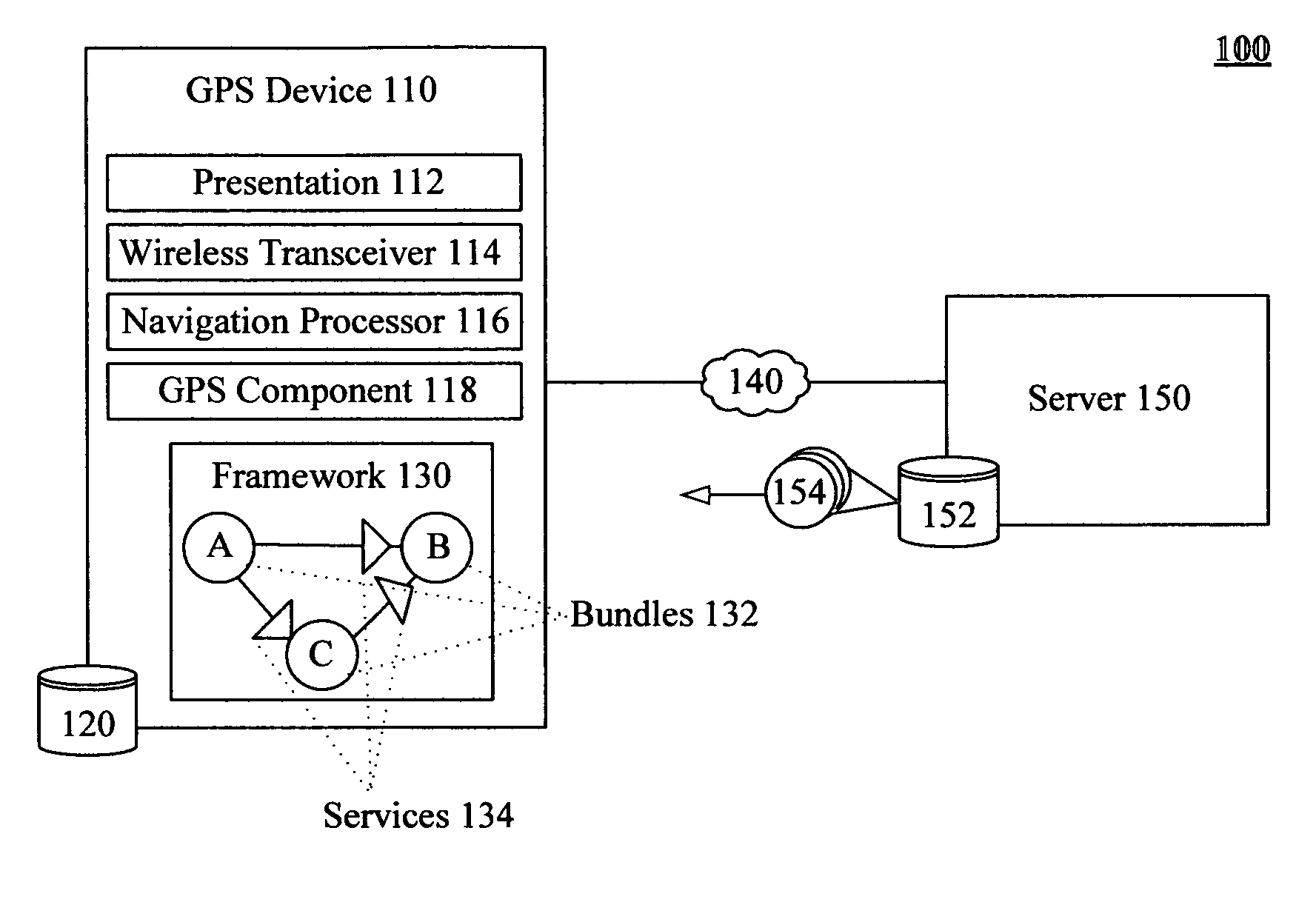
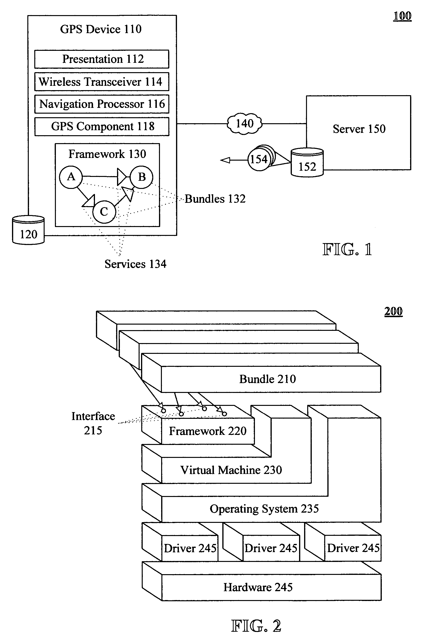
[0027]FIG. 1 is a schematic diagram of a system 100 including a GPS equipped device having a predictive algorithm which loads bundles that include geographical region specific navigation data in accordance with an embodiment of the inventive arrangements disclosed herein. System 100 can include a bundle server 150 that is communicatively linked to one or more Global Positioning System (GPS) equipped devices 110 over network 140. The system 150 can access data store 152, which includes a plurality of geographical navigation bundles 154. The server 150 can continuously update the bundles 154 to ensure that each bundle 154 contains accurate information.

[0028]A geographical navigation bundle 154 corresponds to a defined geographical region and includes a navigation data set for that geographical region. The navigation data set can include relatively static information, such as street level mappings, terrain and elevation information, and points of interest within the region. The navigat...


PUM


Abstract

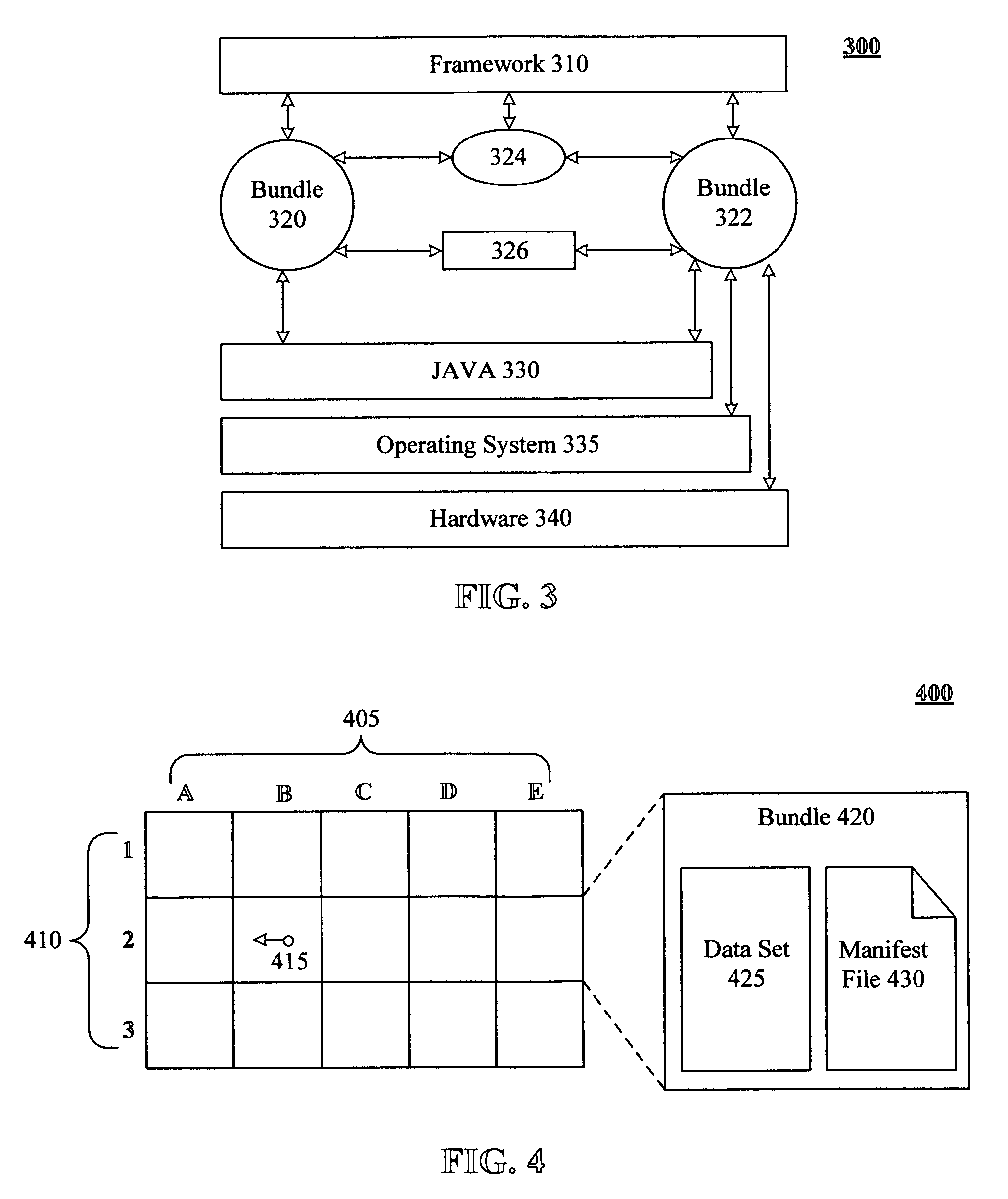
A method for providing and utilizing navigation data can include identifying a grid that includes a plurality of geographical regions. Each geographical region can have an associated navigation data set which includes street level mapping data. Linking references for each geographical region can be defined. Geographical navigation bundles can be identified that conform to an OSGi compliant framework. Each bundle can correspond to one of the geographical regions and can include a navigation data set and a manifest file. The manifest file can include a version, date, and the linking references. A GPS equipped device can dynamically install and activate the geographical navigation bundles. The GPS equipped device can perform at least one navigation process based upon the navigation data set. The GPS device can predict when new navigation data is needed and can automatically acquire suitable geographical navigation bundles in response to these predictions.

Description

BACKGROUND[0001]1. Field of the Invention[0002]The present invention relates to the field of navigation devices and, more particularly, to predictive acquisition and utilization of geographical navigation bundles.[0003]2. Description of the Related Art[0004]Global Positioning Systems (GPS) are increasingly being utilized within a variety of devices for navigation purposes. Many of these devices are portable devices designed for personal or vehicle navigation. When used for navigation, the GPS equipped devices must contain mapping data of local terrain and / or roadway information. Providing this information at a low enough granularity to aid with navigation (such as a granularity that includes street level maps) can require substantial quantities of data. Storing this data upon the GPS device requires that the device be equipped with a large data storage space. A data storage space can be a scarce resource of a portable device. Increasing the size of the storage space of a portable de...

Claims


Application Information

Patent Timeline
Patent Type & Authority Patents(United States)
IPC IPC(8): G06F3/00G06F9/445G08G1/123G01C21/00
CPCG01C21/26
Inventor REICH, DAVID E.
Owner AIRBNB
Learn More