Method and stereo vision system for managing the unloading of an agricultural material from a vehicle

a technology of stereo vision and agricultural material, applied in the direction of vehicle position/course/altitude control, distance measurement, position/direction control, etc., can solve the problems of one or more gps receivers misestimating their position, prior art systems are susceptible to misalignment of proper spacing, etc., to facilitate the transfer of agricultural material

Active Publication Date: 2014-02-11
DEERE & CO
View PDF30 Cites 45 Cited by
  • Summary
  • Abstract
  • Description
  • Claims
  • Application Information

AI Technical Summary

Benefits of technology

[0004]The system and method facilitates the transfer of agricultural material from a transferring vehicle (e.g., harvesting vehicle) to a receiving vehicle. The system and method comprises a receiving vehicle, which has a propelled portion for propelling the receiving vehicle and a storage portion for storing agricultural material. A stereo imaging device faces towards the storage portion of the vehicle. The imaging device can collect image data. A container identification module identifies a container perimeter of the storage portion in the collected image data. The storage portion has an opening, inward from the container perimeter, for receipt of the agricultural material. A spout identification module is adapted to identify a spout of the harvesting vehicle in the collected image data. An alignment module is adapted to determine the relative position of the spout and the container perimeter and to generate command data to the propelled portion to steer the storage portion in cooperative alignment such that the spout is aligned within a central zone of the container perimeter. A steering controller is associated with a steering system of the propelled portion for steering the receiving vehicle in accordance with the cooperative alignment.

Problems solved by technology

However, such prior art systems are susceptible to misalignment of the proper spacing because of errors or discontinuities in the estimated position of the GPS receivers.
For example, one or more of the GPS receivers may misestimate its position because of electromagnetic interference, multipath propagation of the received satellite signals, intermittent reception of the satellite signals or low received signal strength of the satellite signals, among other things.

Method used


Image

  • Method and stereo vision system for managing the unloading of an agricultural material from a vehicle
  • Method and stereo vision system for managing the unloading of an agricultural material from a vehicle
  • Method and stereo vision system for managing the unloading of an agricultural material from a vehicle

Examples


Embodiment Construction

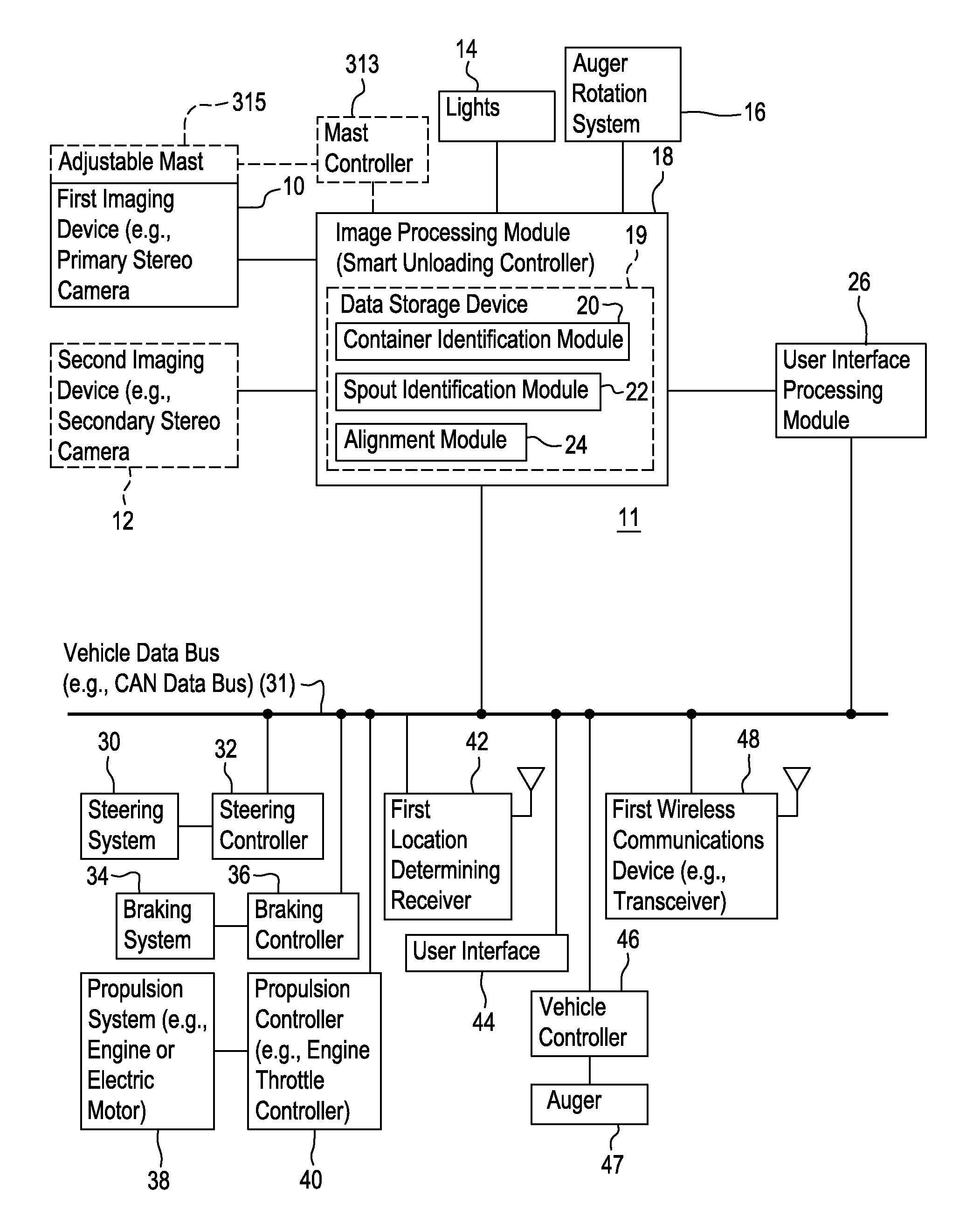
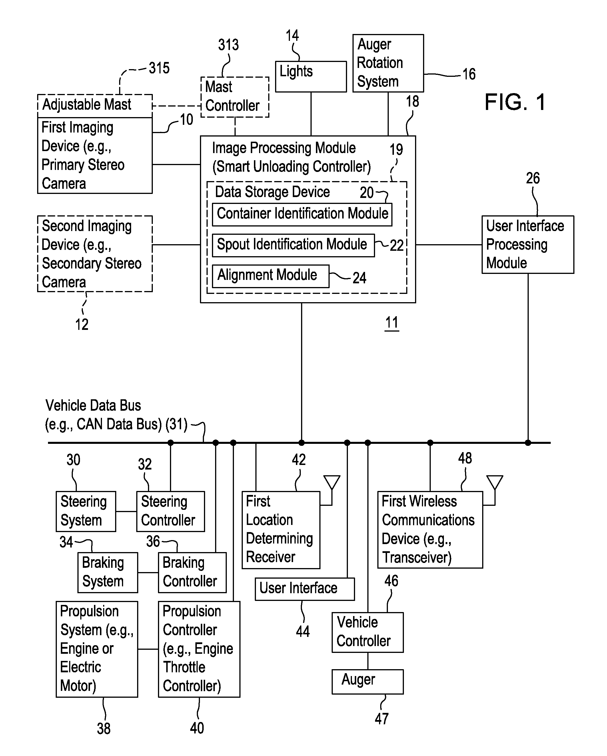
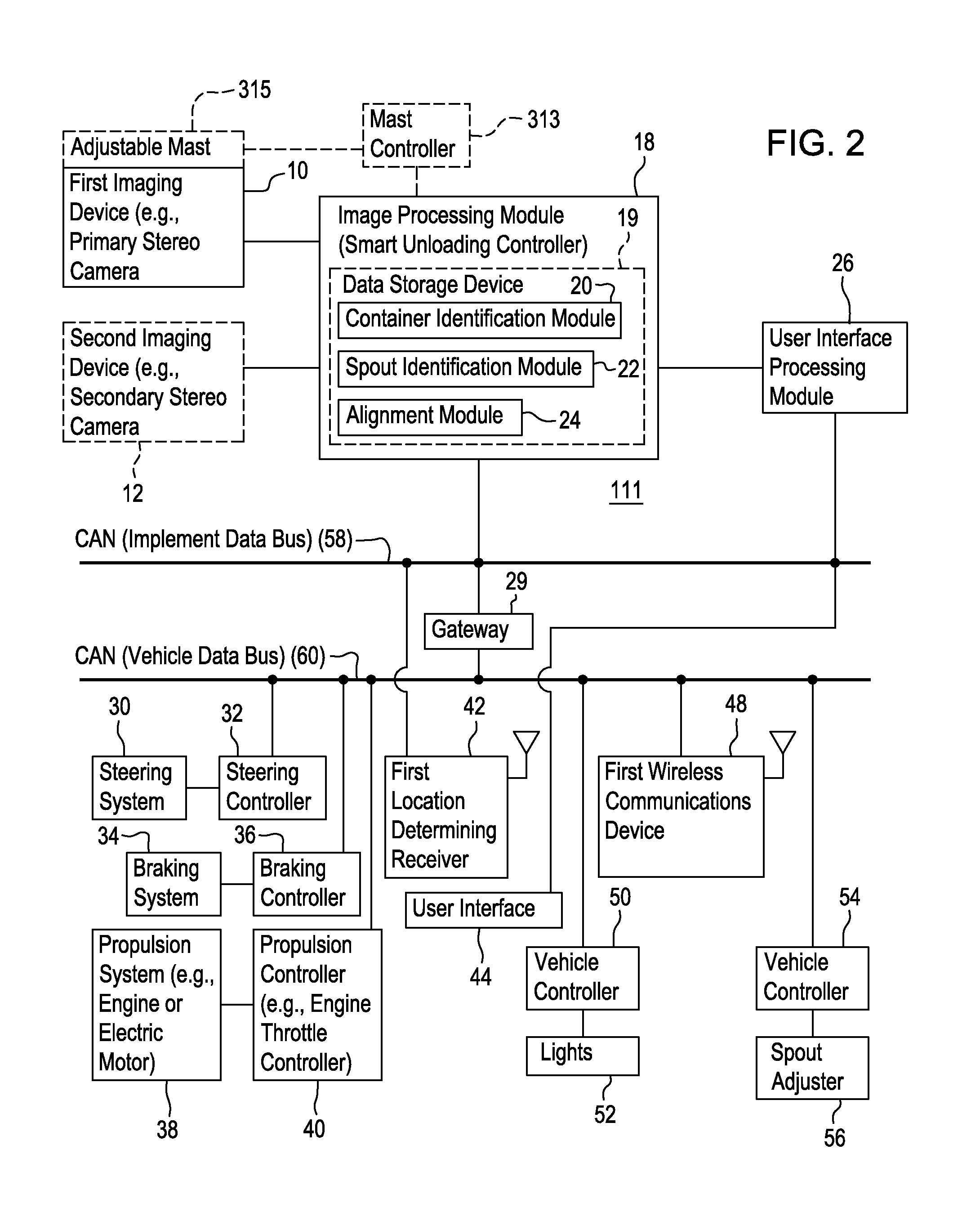
[0014]In accordance with one embodiment, FIG. 1 shows a system 11 for a transferring vehicle for managing the unloading of agricultural material from the transferring vehicle (e.g., combine) to a receiving vehicle (e.g., grain cart or wagon). In one embodiment, the system 11 comprises a first imaging device 10 and second imaging device 12 coupled to an image processing module 18. The first imaging device 10 may comprise a primary stereo camera, while the second imaging device 12 may comprise a secondary stereo camera. In one configuration, the second imaging device 12 or secondary stereo camera is optional and provides redundancy to the first imaging device 10 in case of failure, malfunction or unavailability of image data from the first imaging device 10. In another configuration, the first imaging device 10 or the second imaging device 12 is mounted on a mast, a telescopic mast, a manually telescopic mast, a retractable mount, a rotatable mount (e.g., with remote control of the ro...


PUM


Abstract

A stereo imaging device on a propelled portion of the receiving vehicle collects image data. A container identification module identifies a container perimeter of a storage portion in the collected image data. A spout identification module is adapted to identify a spout of the harvesting vehicle in the collected image data. An alignment module is adapted to determine the relative position of the spout and the container perimeter and to generate command data to the propelled portion to steer the storage portion in cooperative alignment such that the spout is aligned within a central zone or target zone of the container perimeter. A steering controller is associated with a steering system of the propelled portion for steering the receiving vehicle in accordance with the cooperative alignment.

Description

RELATED APPLICATION[0001]This application claims the benefit of the filing date of and priority to U.S. Provisional Application Ser. No. 61 / 597,325, filed Feb. 10, 2012, which is incorporated herein by reference in its entirety.FIELD OF THE INVENTION[0002]This invention relates to a method and stereo vision system for managing the unloading of agricultural material from a vehicle.BACKGROUND[0003]Certain prior art systems may attempt to use global positioning system (GPS) receivers to maintain proper spacing between two vehicles during the unloading or transferring of an agricultural material between the vehicles. However, such prior art systems are susceptible to misalignment of the proper spacing because of errors or discontinuities in the estimated position of the GPS receivers. For example, one or more of the GPS receivers may misestimate its position because of electromagnetic interference, multipath propagation of the received satellite signals, intermittent reception of the sa...

Claims


Application Information

Patent Timeline
Patent Type & Authority Patents(United States)
IPC IPC(8): A01B69/00
CPCA01B69/008B62D12/02A01D43/086A01D43/087G05D1/0251G05D2201/0201A01B69/001
Inventor BONEFAS, ZACHARY, T
Owner DEERE & CO
Why Eureka
Try Eureka