Submarine topography construction method based on multi-source water depth data integration

a construction method and water depth data technology, applied in the field of submarine mapping, computer graphics, submarine sciences, can solve the problems of high accuracy, difficult to integrate multi-source data, and the accuracy of data is far from that of multi-beam sounding, so as to improve the quality of historical data

Active Publication Date: 2016-06-07
SECOND INST OF OCEANOGRAPHY MNR
View PDF9 Cites 0 Cited by
  • Summary
  • Abstract
  • Description
  • Claims
  • Application Information

AI Technical Summary

Benefits of technology

[0082]The present invention realizes conversion, evaluation, correction, integration and splicing of multi-source water depth data and gives detailed technical flow and method, and can effectively utilize the multi-source data during a marine mapping process, thus achieving the construction and electronic mapping of the submarine topography, overcoming the difficult utilization of the traditional historical water depth data, improving the quality of the historical data and the comprehensive utilization rate of multi-source data, and having very important practical application values in marine mapping, computer graphics and submarine scientific studies.

Problems solved by technology

However, the accuracy of the data is far cry from that of the multi-beam sounding.
How to have an opportunity to integrate multi-source data is a more difficult problem in preparing the submarine topography map.
The single-beam sounding data has higher accuracy; however, due to the limit of the investigation cost, the mapping lines are generally rarer, which are difficult to prepare a high accuracy technology map, and particularly difficult to prepare a three-dimensional submarine topography map having a sense of reality.
However, it is very difficult to splice a map when mapping counter spacing differs largely from paper map counter spacing.
Secondly, it is more difficult to construct a counter tree to achieve topology coloring or charting a three-dimensional submarine topography map.
The accuracy of the water depth data measured through satellite altimetry and global topography library is poorer.
Particularly, there are large differences between the data in the sea region shallower than 200 m water depth while being contrasted with that of the data measured through multi-beam sounding, and even a situation of frequently intersections between the counters and islands occurs.
Upon the analysis on the basis of retrieved public data, there is no mature technical method for solving the effective splicing problem of multi-source data in charting a submarine topography map; and particularly, no art is available for the seamless splicing and integration of multi-source data from multi-beam sounding, satellite altimetry, single-beam sounding, historical topography map, and the like.

Method used


Image

  • Submarine topography construction method based on multi-source water depth data integration
  • Submarine topography construction method based on multi-source water depth data integration
  • Submarine topography construction method based on multi-source water depth data integration

Examples


embodiment 1

[0088]A submarine topography construction method based on multi-source water depth data integration is established according to the steps as follows:

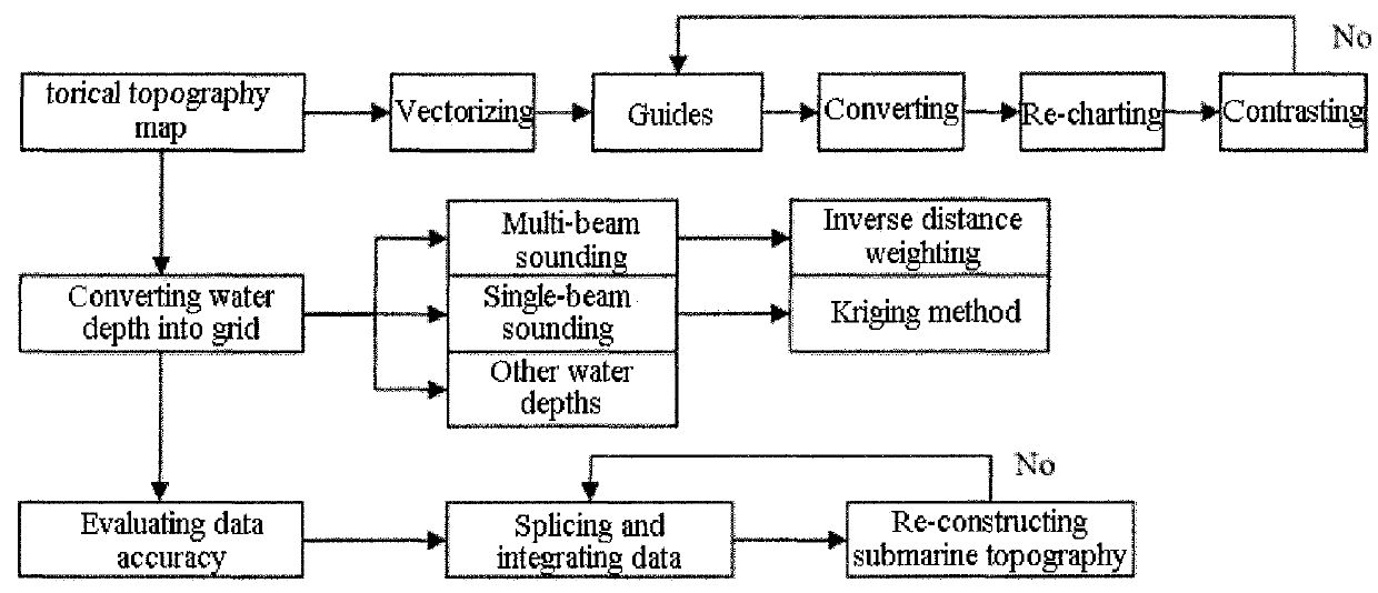
[0089]A complete working flowchart is as shown in FIG. 1.

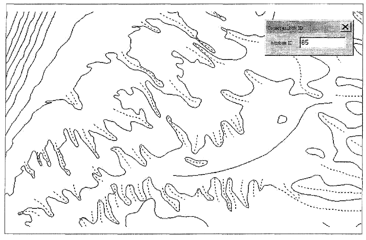
[0090](1) Vectorizing an original submarine topography map. If the original submarine topography map is a paper topography map, a high accuracy scanner needs to be used to convert the paper topography map into an electronic topography map. Then evaluating the accuracy of the scanned topography map according to relevant parameters (frame range, coordinate system and projective mode) of the original map, wherein re-scanning is required in case of deformation. Performing electronic vectorization on the topography map the accuracy of which meets the requirement, and reserving the depth attribute of each counter, wherein the vectorized electronic topography map needs to be perfectly matched with the original map, and the vectorized electronic topography map forms an electronic topograp...


PUM


Abstract

The invention discloses a submarine topography construction method based on multi-source water depth data integration, which achieves reasonable splicing of various data such as multi-beam sounding, single-beam sounding, historical topography map and global topography and submarine topography construction. The invention comprises the following steps of: converting a historical submarine topography map into grid data, converting water depths of other sources into grids, using an overlapping and contrasting method to evaluate the accuracy of the water depths of different sources; using a multi-map-layer method to carry out integration, cutting and splicing on multi-source water depth data, constructing an error distribution model to reasonably revise and integrate various-source water depth data; and constructing multi-source water depth submarine topography and grid. The submarine topography construction method has the advantages that in marine mapping and charting process, the multi-source data can be effectively used, the historical water depth data accuracy and the comprehensive utilization efficiency are promoted, and the submarine topography construction method has important practical application values in marine mapping, submarine topography charting and submarine scientific studies.

Description

[0001]This is a U.S. national stage application of PCT Application No. PCT / CN2014 / 072136 under 35 U.S.C. 371, filed Feb. 17, 2014 in Chinese, claiming the priority benefit of Chinese Application No. 201310282885.4, filed Jul. 8, 2013, which is hereby incorporated by reference.TECHNICAL FIELD[0002]The present invention relates to the technical fields of marine mapping, computer graphics, submarine sciences and the like.BACKGROUND ART[0003]A mapping data blank region frequently exists while mapping due to the regional and phased attributes of multi-beam sounding. For the beauty of the prepared maps, it needs to supplement submarine topography data from other sources, such as historical topography map (including paper medium and electronic topography map), global topography library data, satellite altimetry data and single-beam sounding, and the like. However, the accuracy of the data is far cry from that of the multi-beam sounding. How to have an opportunity to integrate multi-source ...

Claims


Application Information

Patent Timeline
Patent Type & Authority Patents(United States)
IPC IPC(8): G06T17/05G06T7/00G06T11/60G06T19/20G06T19/00G06T5/00G01S15/89G01S15/02
CPCG06T17/05G01S15/025G01S15/89G06T5/008G06T7/0032G06T11/60G06T19/00G06T19/20G01S15/86Y02A90/30
Inventor WU, ZIYINLI, SHOUJUNSHANG, JIHONGLI, JIABIAOLUO, XIAOWENJIN, XIAOBINGZHAO, DINENGZHOU, JIEQIONG
Owner SECOND INST OF OCEANOGRAPHY MNR
Why Eureka
Try Eureka