Method and system for classifying a terrain type in an area

a technology of terrain type and method, applied in the field of method for classifying terrain type in an area, can solve the problem of limited computational power and achieve the effect of improving the accuracy of image analysis

Active Publication Date: 2016-06-14
MAXAR INT SWEDEN AB
View PDF5 Cites 11 Cited by
  • Summary
  • Abstract
  • Description
  • Claims
  • Application Information

AI Technical Summary

Benefits of technology

[0012]One object of the present disclosure is to provide an improved way of classifying terrain types. Another object of the present disclosure is to provide an alternative way of classifying terrain types.
[0014]By doing this only limited computational power is required since no stereo matching is needed. It is further not required that the images match each other well in their appearance, for example concerning the time of the year on which they were taken, which results in the effect that more images can be used and therefore a more reliable result for the terrain type can be achieved. Since the terrain type index is calculated for each of the plurality of the images, a “wrong” terrain type index in one or a few of the pluralities of the pictures will likely not affect the final classification too much. Problems with shadows are, for example, reduced. This is due to the fact that images in the plurality of the images usually are taken at different times of day and / or different times of the year so that the shadows are at different areas on different images. The shadows in each respective image do not heavily contribute when determining the effective terrain type index. Also other reasons for wrong classification are reduced. Boats, ships, or other moving water-based objects which usually would be classified as small islands will not do so with the present method.
[0018]In one example of the method the aerial images are images taken from at least one satellite. This allows for easily classifying large areas. Especially if the images are provided from several satellites, a larger amount of images will be available. This will increase the accuracy and / or the reliability of the determined at least one effective terrain type and thus of the classification of the area with the terrain type.
[0019]In one example the method further comprises a step of calibrating said plurality of aerial images of an area for at least one wavelength band and preferably for all wavelength bands which are used for calculating the at least one terrain type index. This improves the accuracy of the calculated terrain type indices and thus the determined at least one effective terrain type index even further.
[0020]In one example of the method the step of determining the at least one effective terrain index for each part of the area comprises using a voting mechanism and / or a statistical method. This is especially useful for removing wrong classifications due to shadows, moving objects, or the like. Further, voting and / or statistical methods are computationally easy to calculate.
[0023]In one example the method further comprises a step of obtaining at least one shadow mask. This allows for removing unreliable results from the method and thus provides a method where wrong classifications of the terrain type are even further reduced.

Problems solved by technology

By doing this only limited computational power is required since no stereo matching is needed.

Method used


Image

  • Method and system for classifying a terrain type in an area
  • Method and system for classifying a terrain type in an area
  • Method and system for classifying a terrain type in an area

Examples


Embodiment Construction

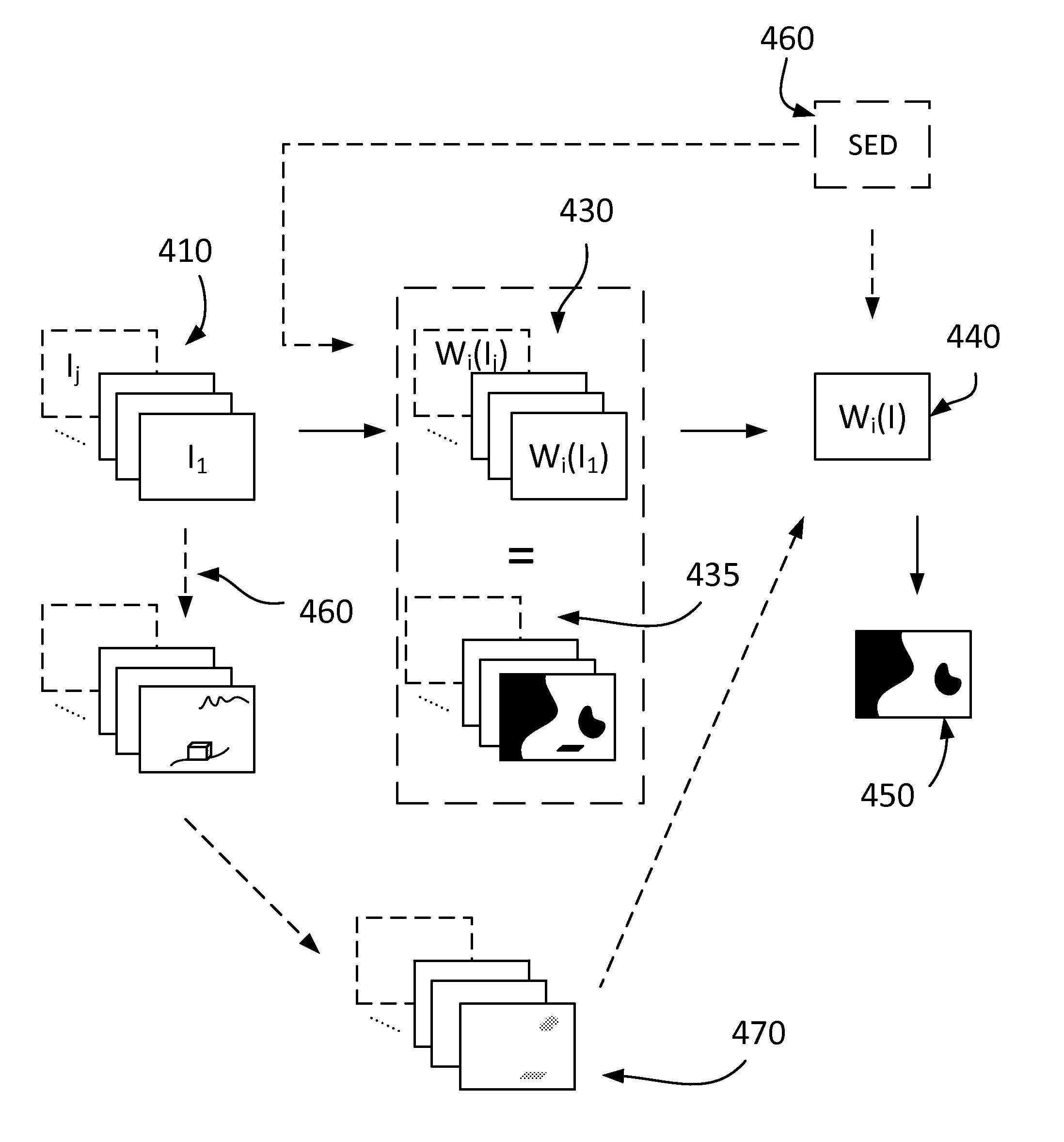
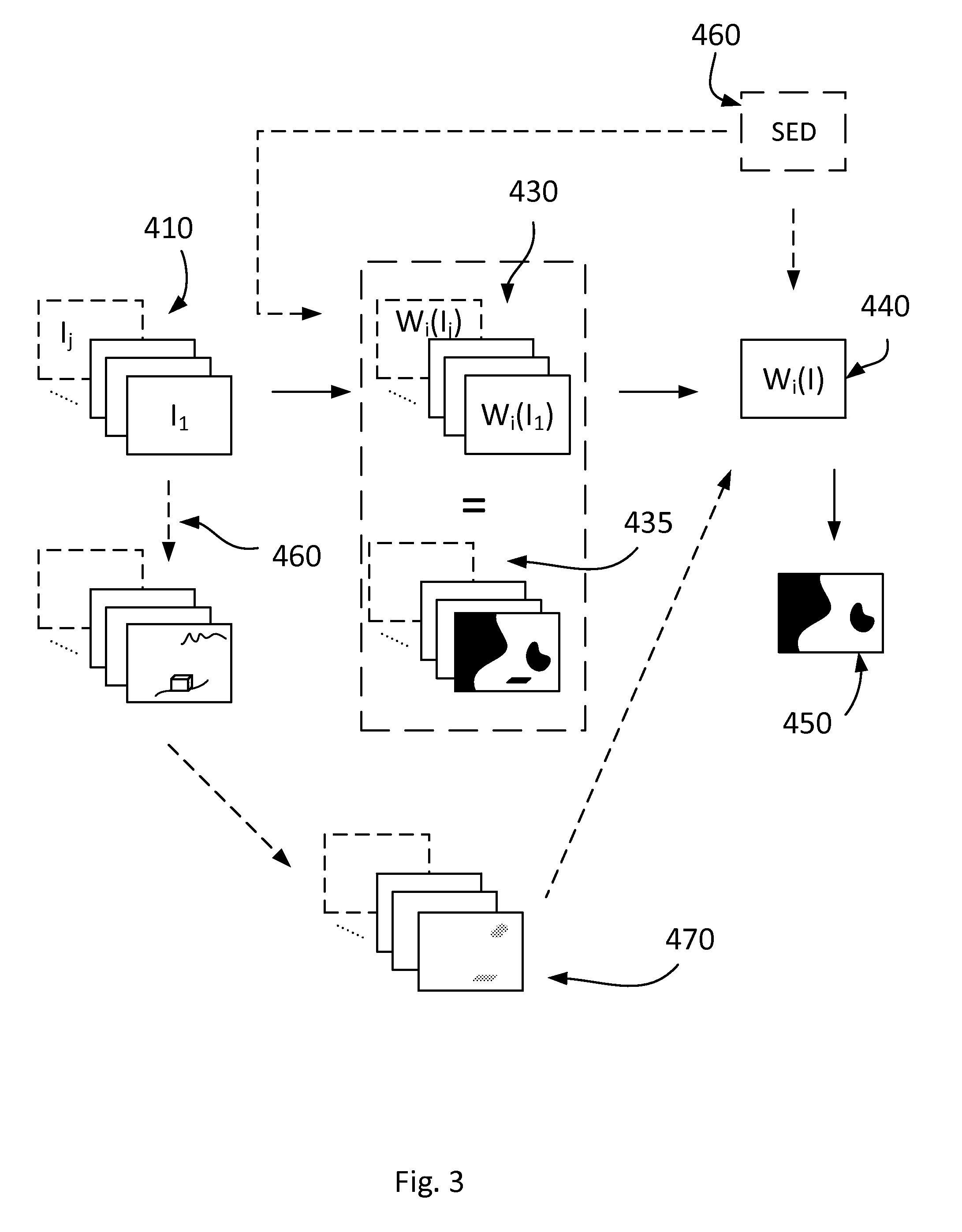
[0040]In the following, the description will only focus on water as a terrain type and a water index as a terrain type index. It should, however, be understood that the application of the teaching of this disclosure is not limited to water but applicable to any other terrain type. Examples of other terrain types are rock, forest, agricultural area, constructions, and infrastructure. Terrain type indices can be defined for these other terrain types in a similar way as the water index defined in the background art. The reflectance can be chosen from wavelength band(s) suitable for specifically pointing out the terrain type. Also terrain type indices defined with more than two reflectances or by completely different formulae can be used within the scope of this disclosure.

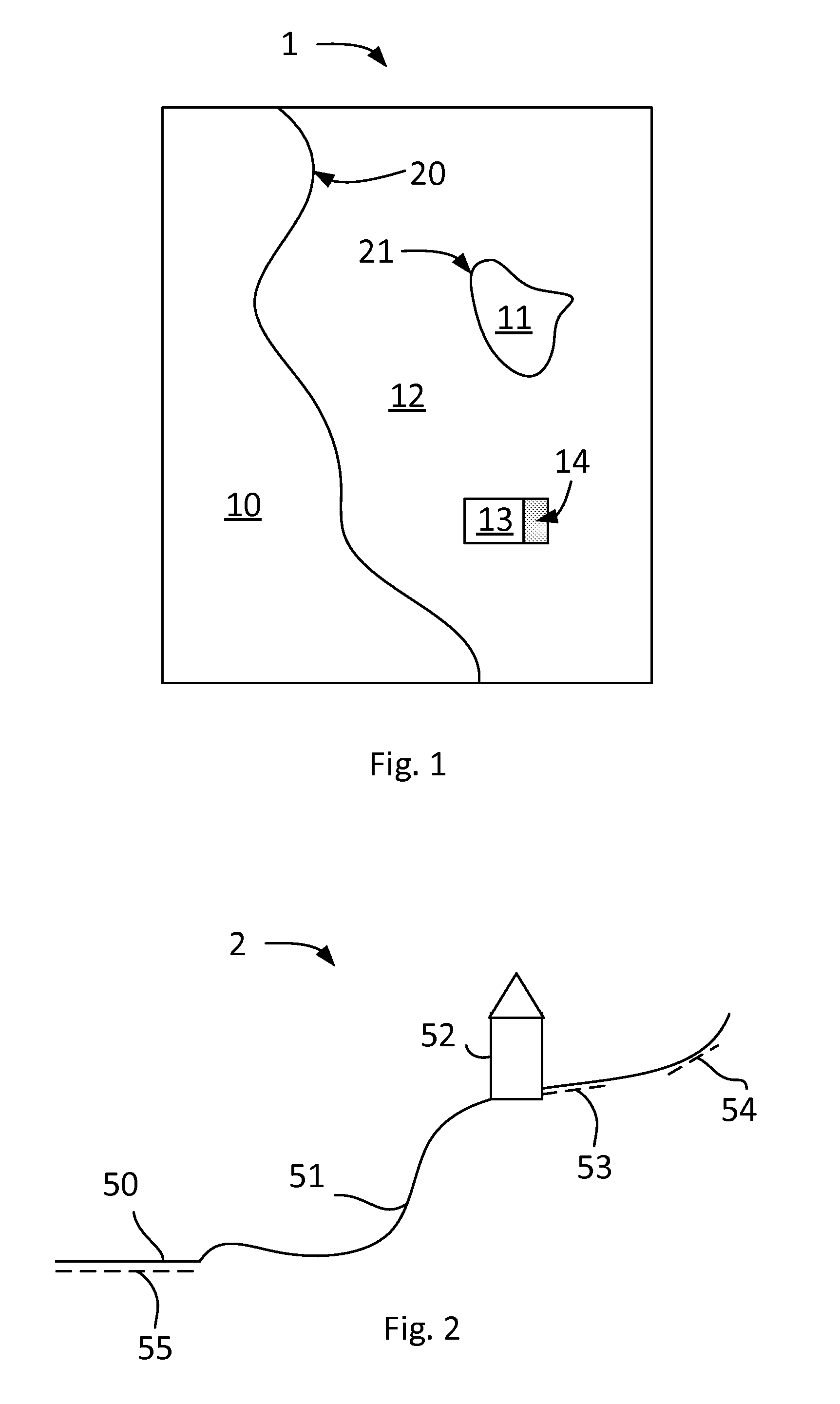
[0041]FIG. 1 shows a sketch of an image 1 with a scene as can be seen when the image is an aerial image. The aerial image can, for example, originate from an airplane, a helicopter, a balloon, an unmanned aerial vehic...


PUM


Abstract

A method for classifying a terrain type in an area is provided, which method comprises the steps of: obtaining a plurality of overlapping aerial images of the area; calculating at least one terrain type index for each part of each of the aerial images which lies in the area, where the at least one terrain type index represents the terrain type; determining at least one terrain type index for each part of the area based on the calculated at least one terrain type index for each part of each of the aerial images; and classifying the parts of the area for which at least one pre-determined conditions is met as containing the terrain type, wherein at least one of the at least one predetermined condition relates to a value of the determined at least one terrain type index. An associated system and computer program product are also provided.

Description

BACKGROUND[0001]1. Related Field[0002]The present disclosure relates to a method for classifying a terrain type in an area. It also relates to a system for classifying a terrain type in an area, to a computer program and a computer program product.[0003]2. Related Art[0004]Satellites used for providing pictures of the Earth's surface can often generate multi-spectral images, i.e. the images generated by these satellites can comprise information in different wavelength areas, for example from ultraviolet (UV) to infrared (IR). As an example, the satellites WorldView-2 and WorldView-3 operated by the company DigitalGlobe provide images from eight different spectral bands named coastal blue (400-450 nm), blue (450-510 nm), green (510-580 nm), yellow (585-625 nm), red (630-690 nm), red-edge (705-745 nm), near IR (NIR) 1 (770-895 nm), and NIR2 (860-1040 nm).[0005]The images can be analysed for identifying, for example, water, other terrain types, cities, etc. For identifying water, a wat...

Claims


Application Information

Patent Timeline
Patent Type & Authority Patents(United States)
IPC IPC(8): G06K9/00G06T7/00G06T17/05G06V20/13
CPCG06K9/0063G06T7/0053G06T17/05G06T2207/10036G06T2207/30181G06T7/507G06V20/13
Inventor HAGLUND, LEIFISAKSSON, FOLKECARLBOM, PERNYGREN, OLABORG, JOHANRINGQVIST, SANNANORDMARK, ANTON
Owner MAXAR INT SWEDEN AB
Why Eureka
Try Eureka