Device, system and method for geological-time refinement

a geological time and refinement technology, applied in the field of stratified terrain modeling, can solve the problems of inaccurate data rendering and incorrect fitting of observed sampling points, and achieve the effects of preventing “bubbles”, accurately modeling, and simplifying computational complexity

Active Publication Date: 2017-06-27
ASPEN PARADIGM HLDG LLC
View PDF117 Cites 4 Cited by
  • Summary
  • Abstract
  • Description
  • Claims
  • Application Information

AI Technical Summary

Benefits of technology

[0009]In the geological space as observed today, the geometry of the horizons may be intrinsically defined as level-sets of the geological-time function. Therefore, improving the geometry of the horizons in a depositional model of the subsurface may be equivalent to improving or refining the geological-time function. To solve such a model refinement problem, a new approach is proposed, referred to as “Geological-Time Refinement” (GTR). Contrary to classical 3D interpolation methods which typically generate bubbles in the presence of strong lateral variations of layer thickness, the GTR technique models a “refined” geological-time function and associated horizons correctly. As an input, the GTR technique uses a set of given sampling points located on a given series of reference horizons and an initial strictly monotonic 3D geological time function whose level sets approximate the reference horizons. As an output, the GTR technique generates a new refined (e.g. strictly monotonic) approximation of the 3D geological-time function whose level-sets corresponding to the reference horizons better fit the sampling points without forming bubbles.
[0016]According to some embodiments of the invention, this two-stage approach may overcome the aforementioned deficiencies of the prior art, by providing a separate 1D interpolation stage that allows discontinuities of the gradient of the geological time function across reshaped reference horizons to be taken into account, for example within a fault block. By allowing discontinuities of the gradient of the geological time function (e.g. not C1) while preserving continuity of the geological-time function (e.g. C0), the refined model may maintain a strictly monotonic geological time function within each fault block, thereby preventing “bubbles” from forming in the models. This type of refinement presents an important advantage to accurately model such gradient discontinuities that occur in geology, for example, at a passive margin (e.g. a transition between oceanic and continental lithosphere as shown in FIG. 1). In addition, by dividing a 3D interpolation into two separate 1D and 2D interpolation stages, embodiments of the invention may significantly simplify the computational complexity of the 3D interpolation, thereby reducing the computation effort and / or time to improve the function of the computer performing the interpolation.

Problems solved by technology

Current interpolation techniques for generating depositional models typically use extensive simplifications that often violate for example principles of superposition and minimal energy deformations, thereby rendering inaccurate data.
Unfortunately such severe smoothing causes the observed sampling points to be incorrectly fitted.

Method used


Image

  • Device, system and method for geological-time refinement
  • Device, system and method for geological-time refinement
  • Device, system and method for geological-time refinement

Examples


Embodiment Construction

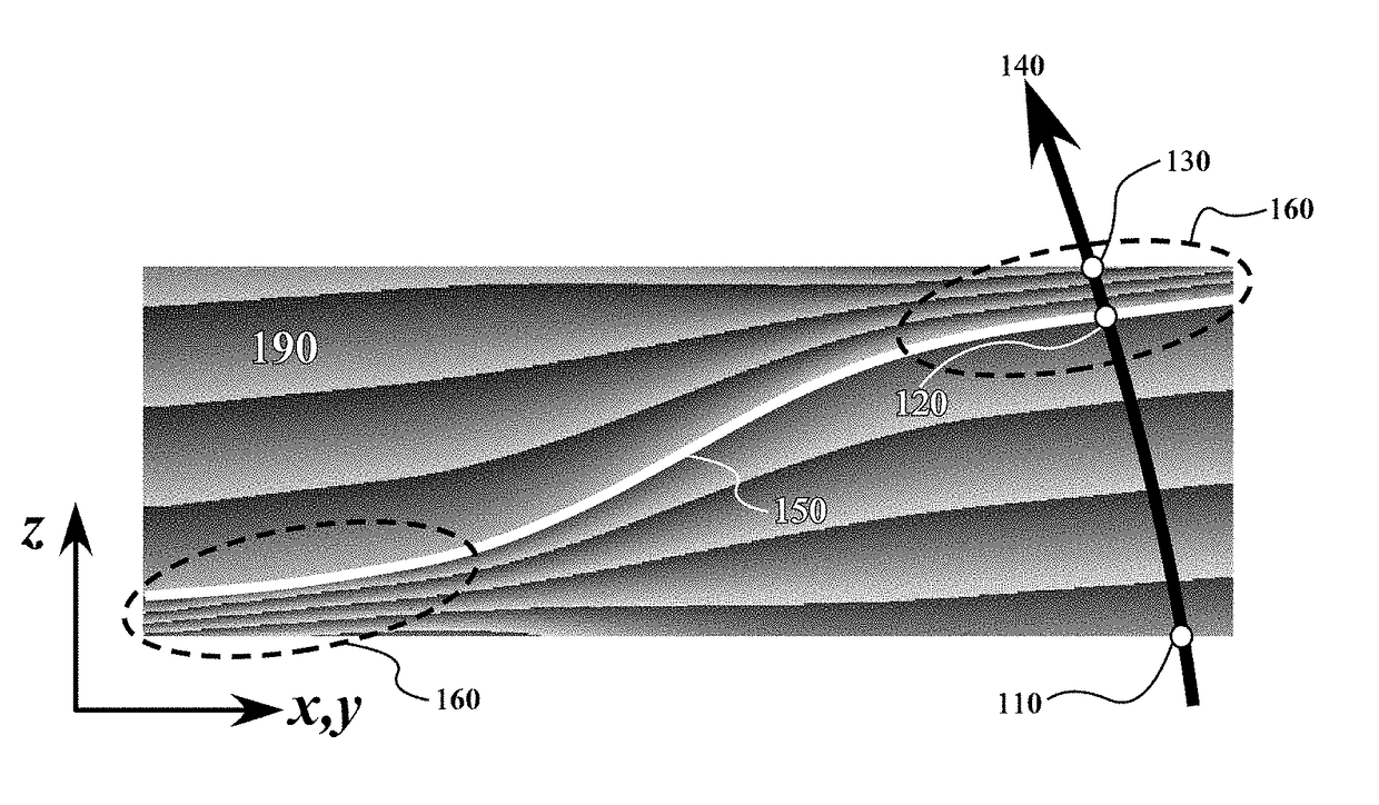
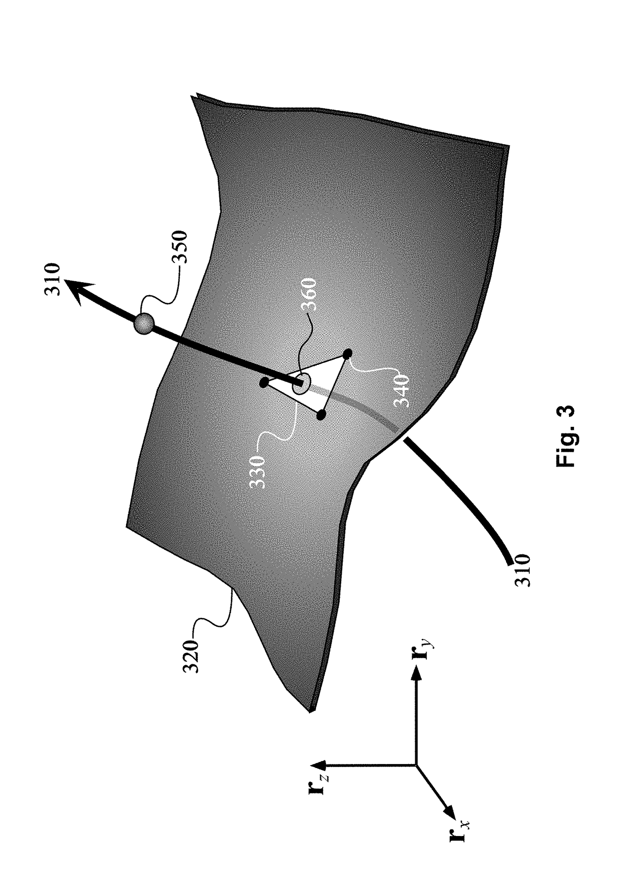
[0008]According to an embodiment of the invention, a device, system and method is provided for refining a geological-time (and / or geological horizons), for example, of geological structures composed of geological strata bounded by geological horizons ordered according their geological time of deposition (e.g. the GeoChron model).

[0009]In the geological space as observed today, the geometry of the horizons may be intrinsically defined as level-sets of the geological-time function. Therefore, improving the geometry of the horizons in a depositional model of the subsurface may be equivalent to improving or refining the geological-time function. To solve such a model refinement problem, a new approach is proposed, referred to as “Geological-Time Refinement” (GTR). Contrary to classical 3D interpolation methods which typically generate bubbles in the presence of strong lateral variations of layer thickness, the GTR technique models a “refined” geological-time function and associated hori...


PUM


Abstract

A device, system and method for performing a 3D interpolation in a 2D interpolation stage and a 1D interpolation stage to generate a refined geological-time. A 3D model may be obtained of a subsurface region defined by an initial geological-time in the past when particles in the subsurface region are determined to have been originally deposited. The stages of the 3D interpolation may include a 2D interpolation along one or more initial 2D reference horizon surfaces to generate one or more reshaped 2D reference horizon surfaces, and a 1D interpolation based on the initial geological-time along one or more 1D interpolation lines to generate a refined geological-time, wherein each 1D interpolation line is approximately orthogonal to the initial 2D reference horizon surfaces. The 3D model may be displayed according to the refined geological-time.

Description

FIELD OF THE INVENTION[0001]Embodiments of the invention relate generally to modeling stratified terrains in the subsurface of the Earth, and more particularly to modeling terrains based on the geological time in the past when the subsurface terrains were originally deposited in the Earth.BACKGROUND OF THE INVENTION[0002]Tectonic activity through time transforms an initially uniform stratified terrain composed of a continuous stack of substantially level surfaces into an uneven terrain that may be eroded, affected by shifts in sedimentary deposition patterns, folded, and / or fractured by faults forming discontinuities across the originally continuous horizons. To model the original past time of deposition, referred to as “geological time”, from data collected from the current present-day subsurface structures (e.g., to “reverse time”), a depositional model (e.g. referred to as a “GeoChron” model) may simulate a reversal of such erosion and tectonic activity.[0003]“Geological horizons...

Claims


Application Information

Patent Timeline
Patent Type & Authority Patents(United States)
IPC IPC(8): G01V1/36G01V1/24G01V1/34G01V99/00
CPCG01V1/36G01V1/24G01V1/345G01V99/005G01V2210/57G01V2210/661G01V2210/74G01V1/282
Inventor MALLET, JEAN-LAURENTTERTOIS, ANNE-LAURE
Owner ASPEN PARADIGM HLDG LLC
Why Eureka
Try Eureka