
Systems and methods for determining a position of a vehicle based on information collected by communications equipment along a known route

Active Publication Date: 2017-08-15
ROCKWELL COLLINS INC
View PDF7 Cites 8 Cited by
  • Summary
  • Abstract
  • Description
  • Claims
  • Application Information

AI Technical Summary

Benefits of technology

The patent text discusses the issue of failures in existing methods of identifying the position of a vehicle along a known route, such as a rail track. These failures can due to factors such as flooding and corrosion of track wayside loops, poor visibility, and deliberate tampering with systems. It proposes a solution of using multiple overlays to reduce the impact of any single failure. This can include advanced signaling, facilitating routing adjustment, and providing passenger information. The text also mentions the use of other modern technologies that can be adapted to trains or vehicles, such as GPS and wireless transceivers, to provide redundant position locating capability and enhance safety, especially when other communication systems fail. The technical effects of the patent text include reducing reliance on dedicated position locating systems and providing a more accurate and reliable means of identifying the position of vehicles along known routes.

Problems solved by technology

These AVL systems also may not be particularly adaptable to trains based on an amount of time that a train may spend out of an environment in which GPS localization is available.
Typically, because trains and other constrained-path vehicles are limited in their freedom of movement, advanced technology systems for resolving positions of the trains and / or other constrained-path vehicles may be considered wasteful, i.e., not cost effective based on the need for extensive supporting computer overhead.
Existing methods of positively identify positions of a vehicle along a known route, for example, a rail track, are subject to failure.
Examples of situations that cause failures include flooding and corrosion of track wayside loops, failures to acquire GPS locks along routes with poor visibility to overhead satellite constellations, deliberate tampering with systems (including axle counters) and other like difficulties.
Explicitly installing equipment for each of these purposes, however, regardless of the effectiveness of the equipment, would likely be deemed prohibitively expensive.

Method used


Image

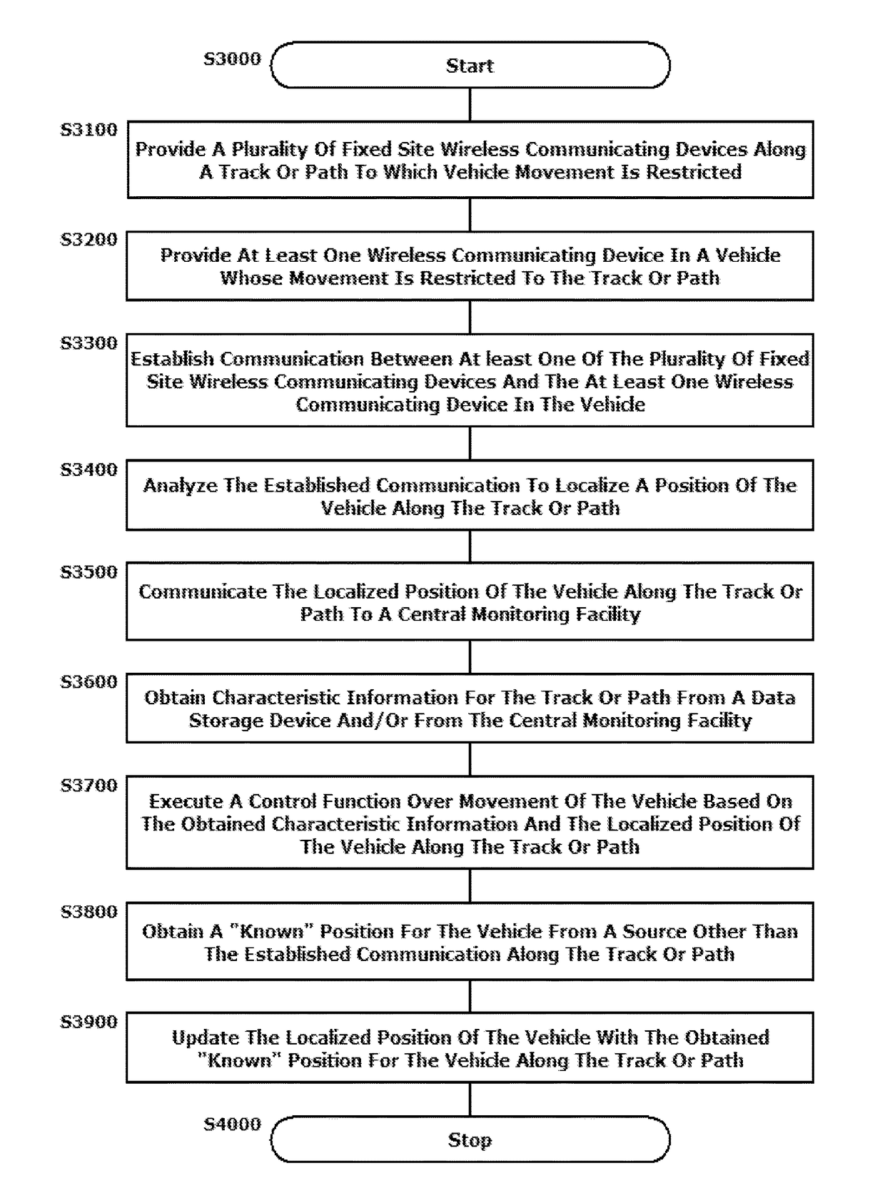
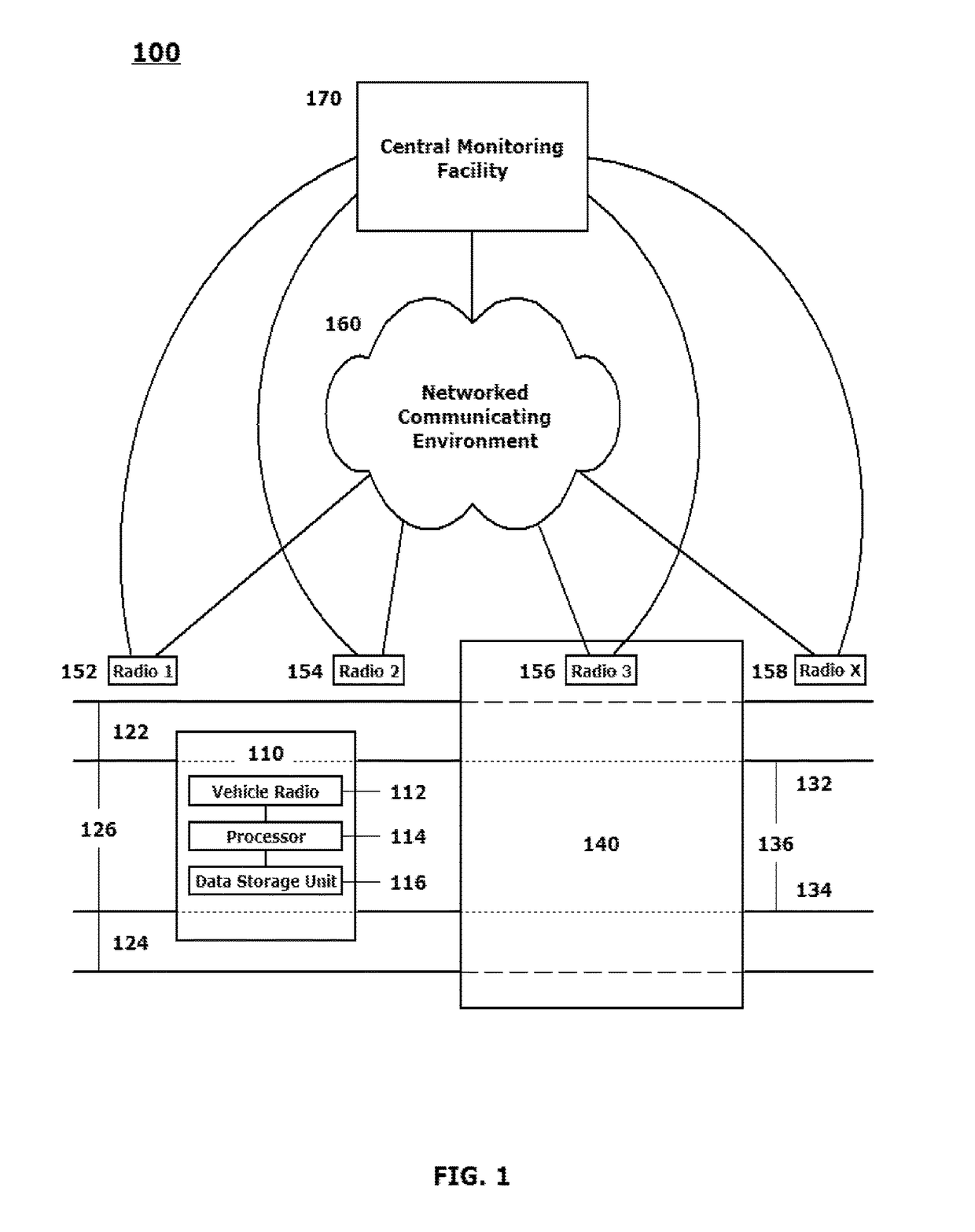
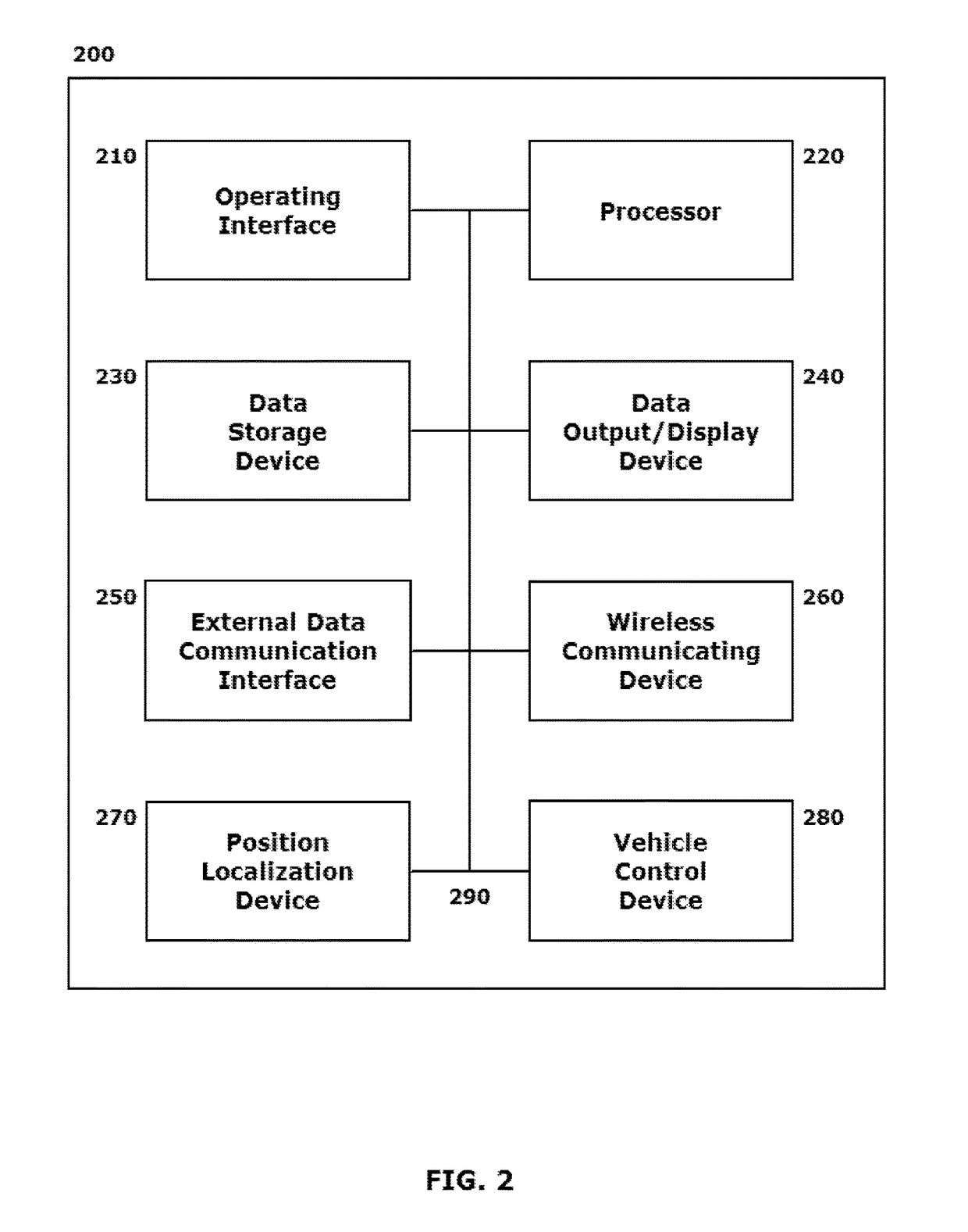
  • Systems and methods for determining a position of a vehicle based on information collected by communications equipment along a known route
  • Systems and methods for determining a position of a vehicle based on information collected by communications equipment along a known route
  • Systems and methods for determining a position of a vehicle based on information collected by communications equipment along a known route

Examples


Embodiment Construction

[0002]This disclosure relates to systems and methods for determining a position of a vehicle traversing a constrained path via environmental information from, and collected by, communications equipment installed both at fixed points along a known route and onboard the traveling constrained path vehicle and communications established between the fixed and moving components of the system.

[0003]2. Related Art

[0004]Various techniques exist for localizing positions of moving vehicles and other moving objects / bodies. Among these techniques are the increasing uses of handheld, or vehicle mounted position keeping devices, and / or implementation of automatic vehicle locators (AVLs). An AVL system, for example, generally includes Global Positioning System (GPS) locators mounted on, for example, the tops of individual vehicles, including busses and trains. The individual locator components provide inputs to a local communication network, such as a cellular, Wi-Fi or other like network that prov...


PUM


Abstract

A system and method are provided for determining a position of a vehicle traversing a constrained path via cooperating communications equipment installed at fixed points along a known route and onboard the vehicle. The disclosed schemes leverage certain commonly-installed communications nodes to provide positioning information for participating vehicles when those vehicles are specifically limited in their movement to a particular path, including a train track. Signal analysis between cooperating nodes provides localization information, including timing information, that is sufficient, given the physical constraints of the participating vehicles to a particular track, lane or the like, to quickly resolve a positional localization for the vehicles. Common wireless transceiver connectivity is used to support a backup position locating system that has an appropriate fidelity to provide a required modicum of safety without stopping movement of all vehicles in a vicinity of a particular location with which other communications may have broken down.

Description

BACKGROUND[0001]1. Field of the Disclosed Embodiments[0002]This disclosure relates to systems and methods for determining a position of a vehicle traversing a constrained path via environmental information from, and collected by, communications equipment installed both at fixed points along a known route and onboard the traveling constrained path vehicle and communications established between the fixed and moving components of the system.[0003]2. Related Art[0004]Various techniques exist for localizing positions of moving vehicles and other moving objects / bodies. Among these techniques are the increasing uses of handheld, or vehicle mounted position keeping devices, and / or implementation of automatic vehicle locators (AVLs). An AVL system, for example, generally includes Global Positioning System (GPS) locators mounted on, for example, the tops of individual vehicles, including busses and trains. The individual locator components provide inputs to a local communication network, such...

Claims


Application Information

Patent Timeline
IPC IPC(8): G08G1/00G01C21/00G08G1/127G01C21/34
CPCG08G1/127G01C21/34B61L3/125B61L25/025B61L27/04G01C21/28B61L2205/04B61L27/20
Inventor LAI, TOM
Owner ROCKWELL COLLINS INC
Learn More