Identifying risky transactions

Active Publication Date: 2017-12-12
EMC IP HLDG CO LLC
View PDF5 Cites 9 Cited by
  • Summary
  • Abstract
  • Description
  • Claims
  • Application Information

AI Technical Summary

Benefits of technology

The patent is about a method and system for identifying risky transactions by creating geographical areas with unique identifiers and mapping the location of a user device to a specific area. The system receives a transaction with location data and compares it to previous transactions in that area to determine if it is risky. The result is an authentication result with a risk score based on the likelihood of the transaction being risky. This technique can be used to protect against fraud and improve security in various applications.

Problems solved by technology

Significant variation of one or more attribute values from those in the customer's history may signify that the banking transaction has a high risk.
In this case, owing to the different IP address and the unusual time that the transaction was submitted, the risk engine would assign a larger risk score to a transaction resulting from the new transaction request.
Unfortunately, there are deficiencies with the above-described conventional risk-based authentication systems.
Because of the nature of data gathering from cell towers and GPS units in mobile devices, it is possible that a risk-based authentication system could perceive a small change in location as a large change and therefore deem it risky.
The translation of GPS coordinates into a geolocation at such a resolution is frequently very sensitive to noise and other external factors.
Similar problems also exist in non-GPS methods of collecting geolocation such as cell tower triangulation.
Such hypersensitivity to noise and other external factors presents a problem for conventional risk-based authentication systems.
Because the conventional risk-based authentication systems described above rely on previous behavior of attributes such as geolocation, a noisy history of geolocation may lead to inaccurate risk scores being assigned to transactions.
In other words, when the process of obtaining geolocation is excessively noisy and therefore unrepeatable, conventional risk-based authentication systems may create a large number of false positives, undermining the ability to identify the riskiest transactions.
Additionally, it should be understood that some conventional risk-based authentication systems can also assign a high risk to transactions from a certain international region.
For example, the systems may assign a high risk to all transactions from a country in the region due to social, economic and / or geopolitical reasons in the country.
However, this imprecise approach can lead to all transactions emanating from the country being treated in a similar manner regardless of the veracity of the transaction.
This approach can deprive customers in the country the opportunity to perform a transaction due to circumstances outside of their control.

Method used


Image

  • Identifying risky transactions
  • Identifying risky transactions
  • Identifying risky transactions

Examples


Embodiment Construction

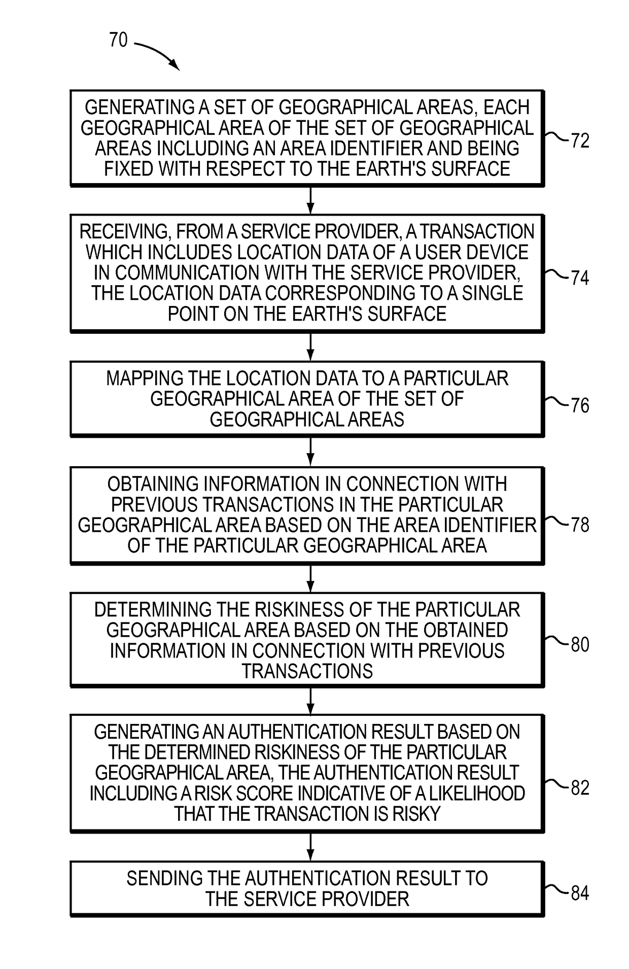
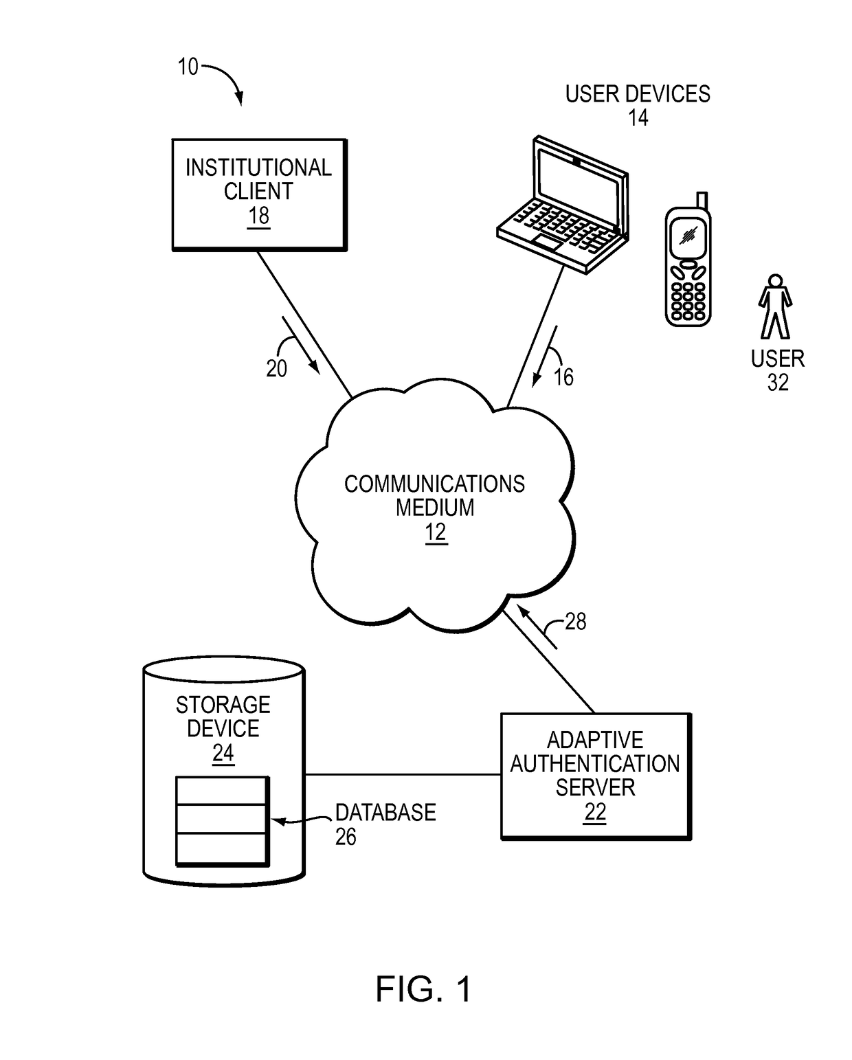
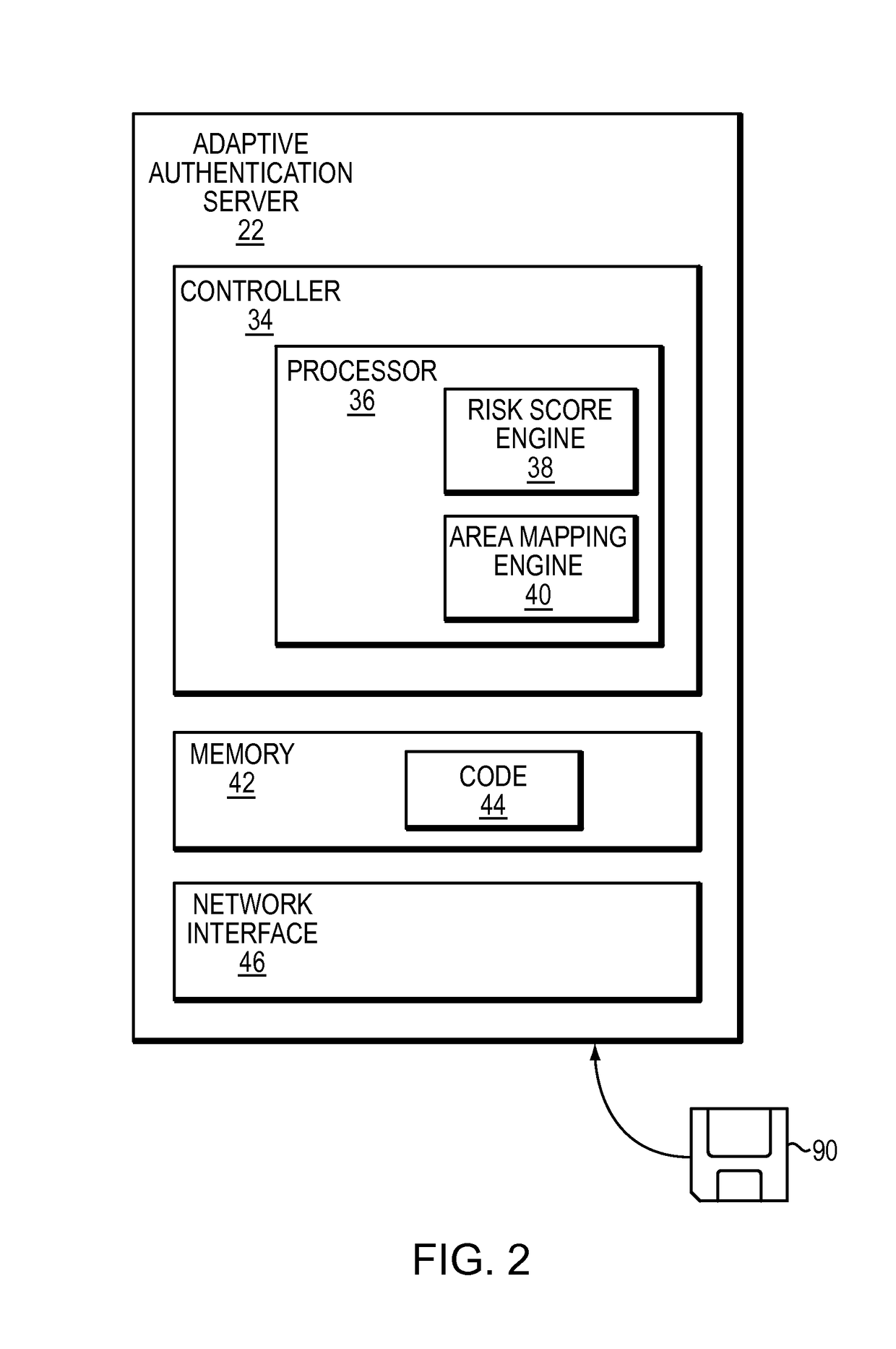
[0020]The technique described below identifies risky transactions by mapping raw user location data to a particular cell in a fixed grid. Along these lines, when a user initiates a transaction with a service provider over a mobile device, the service provider collects raw location data such as a latitude and longitude for the user and transmits the location data to an adaptive authentication server. The adaptive authentication server then accesses a fixed set of geographical areas overlaid on a map of the Earth. For example, the geographic areas can correspond to square cells whose corners are defined by selected latitudes and longitudes. The adaptive authentication server finds a particular geographical area which contains the latitude and longitude for the user. The adaptive authentication server then obtains information in connection with previous transactions in the particular geographical area using the identifier of the particular geographical area to obtain the information. B...


PUM


Abstract

A technique identifies risky transactions by mapping raw user location data to a particular cell in a fixed grid. Along these lines, when a user initiates a transaction with a service provider over a mobile device, the service provider collects raw location data such as a latitude and longitude for the user and transmits the location data to an adaptive authentication server. The adaptive authentication server then accesses a fixed set of geographical areas overlaid on a map of the Earth. The adaptive authentication server finds a particular geographical area which contains the latitude and longitude for the user. The adaptive authentication server also obtains information in connection with previous transactions in the particular geographical area using the identifier of the particular geographical area to obtain the information. Based on this information, the adaptive authentication server determines the riskiness of the particular geographical area. Based on the riskiness, the adaptive authentication server assigns a risk score to the transaction.

Description

RELATED APPLICATION[0001]This application is a continuation-in-part application claiming priority to co-pending U.S. patent application Ser. No. 13 / 340,829, filed Dec. 30, 2011, reference no. EMC-11-516, entitled “METHOD OF DEFINING THE USER'S GEOGRAPHIC AREAS FOR RISK ASSESSMENT PURPOSES IN MOBILE CHANNELS”, the entirety of which patent application is hereby incorporated by reference herein.TECHNICAL FIELD[0002]The present invention relates to identifying risky transactions.BACKGROUND OF THE INVENTION[0003]Some service providers use conventional risk-based authentication systems to assess risks of processing customer transactions. For example, an online bank may employ a risk engine of such a risk-based authentication system to assign risk scores to banking transactions where higher risk scores indicate higher risk.[0004]In generating a risk score, the risk engine takes, as input values, various transaction attributes (e.g., time of receipt, IP address). For each customer of the on...

Claims


Application Information

Patent Timeline
IPC IPC(8): G06Q40/08G06Q20/00G06Q20/38
CPCG06Q20/382G06Q20/3224G06Q20/4016
Inventor MAGI, TRIINUEFRAIM, HARELBIGER LEVIN, AYELET
Owner EMC IP HLDG CO LLC
Why Eureka
Try Eureka